Landing on Long Island

Last updated

Landing on Long Island
Part of World War II, Pacific War
Date26 December 1943
Location 5°21′S147°7′E / 5.350°S 147.117°E / -5.350; 147.117
Result Unopposed
Belligerents
Flag of the United States (1912-1959).svg  United States
Flag of Australia (converted).svg  Australia
Flag of Japan.svg  Japan
Commanders and leaders
Flag of the United States (1912-1959).svg Leonard Kaplan
Strength
220
Casualties and losses
none

The Landing on Long Island in the Territory of New Guinea was part of the Huon Peninsula campaign, a series of operations that made up Operation Cartwheel, General Douglas MacArthur's campaign to encircle the major Japanese base at Rabaul. Located at the northern end of the Vitiaz Strait, Long Island was an important staging point for Japanese barges moving between Rabaul and Wewak until 26 December 1943, when a force of 220 Australian and American soldiers landed on the island. It was not occupied by the Japanese at the time, and there was no fighting. At the time, it represented the furthest Allied advance into Japanese-held territory. It was developed into a radar station.

Contents

Background

Geography

Long Island lies at the northern end of the Vitiaz Strait. It is roughly circular in shape, and about 14 miles (23 km) in diameter, [1] with an area of about 160 square miles (410 km2). [2] There are two prominent peaks, the 4,278-foot (1,304 m) Mount Reamur in the north, and the 3,727-foot (1,136 m) Cerisy Peak in the south. Most of the interior is taken up by Lake Wisdom, which is 500 feet (150 m) above sea level. Inside the lake is an active volcanic cone. Offshore there is a 2-to-3.5-knot (3.7 to 6.5 km/h; 2.3 to 4.0 mph) north westerly current. There were two settlements, Bok in the south east and Malala in the north east. The population of the island was about 250, all native. The island had once supported a larger population, but it had been wiped out by a volcanic eruption. [1] The 1660 Plinian eruption was the third largest volcanic eruption recorded in the last 2,000 years. It was more powerful than the 1883 eruption of Krakatoa, and buried Long Island under 30 metres (98 ft) of volcanic ash. [3]

Strategy

Map of Huon Peninsula operations, 1943-44. Long Island is at the top of the map. The Envelopment of the Huon Peninsula 1943-44.jpg
Map of Huon Peninsula operations, 1943–44. Long Island is at the top of the map.

Fighting in the South West Pacific Area in late 1943 and early 1944 was dominated by General Douglas MacArthur's Operation Cartwheel, a series of operations directed at isolating and neutralising Rabaul, the main base of the Imperial Japanese forces. [4] The Huon Peninsula campaign started well, with victories in the landing at Lae and landing at Nadzab but faltered in the face of inclement weather, unfavourable terrain, and tenacious and aggressive Japanese opposition, both on land and in the air. The initiative passed to Lieutenant General Hatazō Adachi's Japanese XVIII Army which launched a series of counter-attacks in the Battle of Finschhafen. [5]

The Allied air, ground and naval forces set out to cut the Japanese supply line, which was by barges moving along the coast between Madang and Fortification Point. [6] Long Island was an important staging point for Japanese barges moving between Rabaul and Madang. In Allied hands, it could be a useful site for a radar station and observation post, [7] and could provide radar coverage for the upcoming landing at Saidor. [8] On 22 December 1943, the commander of Alamo Force, Lieutenant General Walter Krueger, issued his Field Order No. 8, directing the 2nd Engineer Special Brigade to seize Long Island. [9] The operation was codenamed "Sanatogen", [2] and was undertaken concurrently to landings around Cape Gloucester, on New Britain. [10]

Preliminaries

A party of coastwatchers consisting of three Australians from the Allied Intelligence Bureau (AIB) and four natives, were landed on Long Island by a PT boat on 6 October 1943. Their role was to watch for and report on aircraft coming from Madang. At the time of their arrival, there were at least two Japanese parties on the island, but in November they reported that the Japanese had left. [11] The mission commander, Major Leonard Kaplan, [12] flew to Finschhafen on 22 December with two amphibian scouts. At 18:00 the following day they boarded a PT boat that took them to Long Island. They landed on the island at 23:45, guided by lights set up by the AIB. Reassured that there were no Japanese on the island, Kaplan re-embarked and returned to Finschhafen, leaving the two amphibian scouts behind to reconnoitre the island, and to set up lights to guide landing craft during the landing. [13]

Meanwhile, on 22 December the participating elements of the 2nd Engineer Special Brigade set out from Oro Bay for Finschhafen, from whence the assault would be staged. A detachment of 3 officers and 32 men from the Boat Battalion of the 592nd Engineer Boat and Shore Regiment (EBSR) manned three LCVPs and five LCMs. One LCVP acted as a navigation boat; the remaining two, with one officer and eight other ranks, would remain on Long Island with the garrison. The assault troops were 150 men from Company D, Shore Battalion, 592nd EBSR. [13]

At Finschhafen they met up with the Australians of No. 338 Radar Station RAAF, who would man the radar installation on Long Island. [14] This unit had flown in from Jacksons and Wards Airfields around Port Moresby in 11 transport aircraft. [8] It was commanded by Pilot Officer Alan Lum. To help establish the radar station, they were accompanied by some technical experts from No. 41 Wing RAAF. All told, there were 35 RAAF personnel, bringing the assault force to a total of 220 men. [13] A planned rehearsal on 24 December was scrubbed due to an air raid alert. Krueger supervised the drafting of the final landing plan. A final briefing was given at 08:30 on 25 December, and all boats were loaded and equipment stowed by 12:00. The men then sat down to their Christmas dinner of roast turkey. The equipment included two 37 mm guns, four 60 mm mortars, four bazookas, a 5,000-US-gallon (19,000 L; 4,200 imp gal) canvas water tank, a TD9 bulldozer, two jeeps, a jeep trailer with a water tank, and two .50-caliber machine guns. [15]

Landing

The LCMs and LCVPs set out on the 105-mile (169 km) voyage from Finschhafen at 14:15, [12] [16] and made its way along the coast in broad daylight without being engaged by Japanese aircraft or vessels. Three PT boats, carrying the 90 men of Company D who would make up the first wave, set out from Finschhafen at 18:00. Being faster, they overtook the landing craft during the night. They arrived off Malala at 23:45, a quarter of an hour late; but this was of no consequence as there was no preliminary air or naval bombardment owing to there being no Japanese present. The men transferred from the PT boats to six rubber boats. This was not easily accomplished; since there had been no rehearsal, they were unaccustomed to the craft. Guided by the lights the amphibian scouts had set up ashore, the rubber boats set out at 00:20. [16] The surf conditions were rough, and two boats capsized; [17] but neither men nor equipment were lost. [12] The entire first wave was safely ashore by 02:00 on 26 December. [16]

The second wave, the landing craft, arrived off the island at 05:20, eighty minutes late. The beach grade was found to be steep, resulting in a 4-to-6-foot (1.2 to 1.8 m) surf. The force waited until daylight before two LCMs unsuccessfully attempted to beach. They broached, soaking the radar equipment in salt water. A search was then made for a more suitable beach, and one was found south of Cape Reamur. Some 100 measurement tons (110 m3) of equipment were unloaded by 13:00, and the navigation boat LCVP and five LCMs set sail for Finschhafen. The radar equipment was moved inland and covered by tarpaulins. [16] The following night rains caused Lake Wisdom to overflow and the equipment was subjected to a torrent of fresh water. [18]

Outcome

On 27 December 1943 the radar equipment was moved to a 150-foot (46 m) hilltop on the east coast. Two 1,700-pound (770 kg) generators were towed on sleds. [16] The radar station personnel had considerable difficulty keeping the equipment operational in the hot, wet and humid climate, and there were numerous failures. The wet season had begun by the end of December, and the equipment was affected. Two replacement power supplies and a replacement transmitter and receiver for the radar unit arrived on 27 January 1944. By April 1944, the Allies had advanced along the coast to Madang, and the main Japanese air threat was coming from Wewak. No. 338 Radar Station was therefore ordered to move to Matafuna Point on the west coast. This took a week to accomplish. [19] A flying fox was used to bring the equipment back down to sea level. The station was operational again at 19:00 on 11 April 1944. [19] It finally ceased operation on 28 January 1945. [8]

The garrison was for a time the most advanced Allied position in the theatre, and Brigadier General William F. Heavey, the commander of the 2nd Engineer Special Brigade, of which the 592nd EBSR was part, was surprised when its capture was officially announced in December 1943. Rumours were rife among the garrison that the Japanese might attempt to recapture the island and eliminate the radar station. No attempt was made; the Japanese accepted the loss of their staging point. The engineers built defences, camp sites and facilities for the radar station. An airstrip for light Piper Cub aircraft 1,500 feet (460 m) long and 50 feet (15 m) wide was built in five days. Resupply came from Finschhafen in LCMs and the occasional PT boat. On 17 February 1944, the 592nd EBSR Group departed Long Island in an LCVP and seven LCMs of the Boat Battalion. Krueger praised the 592nd EBSR Group, who "by a display of aggressiveness and superior seamanship, accomplished its mission in the face of unusual odds." [20]

Notes

  1. 1 2 Allied Geographical Section 1943, pp. 127–129.
  2. 1 2 Casey 1959, pp. 181–182.
  3. "Long Island volcano". Volcano Discovery. Retrieved 6 December 2017.
  4. Dexter 1961, p. 8.
  5. Coates 1999, pp. 148–177.
  6. "II Corps Report on Operations: October 1943 – March 1944, Australian War Memorial: AWM52 1/4/8" (PDF). pp. 59–60. Retrieved 21 November 2015.
  7. Dexter 1961, p. 731.
  8. 1 2 3 RAAF Historical Section 1995, pp. 67–69.
  9. Krueger 1953, p. 29.
  10. Rottman 2002, p. 190.
  11. Ball 1982, pp. 458–459.
  12. 1 2 3 United States Army 1946, p. 65.
  13. 1 2 3 Casey 1959, p. 182.
  14. Simmonds & Smith 2007, p. 34.
  15. Casey 1959, pp. 182–183.
  16. 1 2 3 4 5 Casey 1959, p. 183.
  17. Heavey 1988, p. 110.
  18. Simmonds & Smith 2007, p. 35.
  19. 1 2 Simmonds & Smith 2007, p. 36.
  20. Casey 1959, pp. 184–185.

Related Research Articles

<span class="mw-page-title-main">Battle of the Bismarck Sea</span> 1943 Allied attack on a Japanese convoy

The Battle of the Bismarck Sea took place in the South West Pacific Area (SWPA) during World War II when aircraft of the U.S. Fifth Air Force and the Royal Australian Air Force (RAAF) attacked a Japanese convoy carrying troops to Lae, New Guinea. Most of the Japanese task force was destroyed, and Japanese troop losses were heavy.

<span class="mw-page-title-main">Battle of Rabaul (1942)</span> WWII battle in the Pacific Theater

The Battle of Rabaul, also known by the Japanese as Operation R, an instigating action of the New Guinea campaign, was fought on the island of New Britain in the Australian Territory of New Guinea, from 23 January into February 1942. It was a strategically significant defeat of Allied forces by Japan in the Pacific campaign of World War II, with the Japanese invasion force quickly overwhelming the small Australian garrison, the majority of which was either killed or captured. Hostilities on the neighbouring island of New Ireland are usually considered to be part of the same battle. Rabaul was significant because of its proximity to the Japanese territory of the Caroline Islands, site of a major Imperial Japanese Navy base on Truk.

<span class="mw-page-title-main">Operation Chronicle</span> Allied landings in Woodlark and Kiriwina during World War II

Operation Chronicle was the Allied invasion of Woodlark and Kiriwina Islands, in the South West Pacific, during World War II. The operation was a subordinate action that formed part of the wider Operation Cartwheel, the advance towards Rabaul. An early planning name for this operation was Operation Coronet. Preliminary actions commenced on 23–24 June 1943 when small reconnaissance parties were landed on both islands. The main operation was executed without opposition on 30 June 1943. Around 16,800 personnel took part, divided into two forces. The United States Army provided the majority of ground troops, which were supported by a United States Marine Corps defense battalion as well as U.S. and Australian aircraft and naval vessels.

<span class="mw-page-title-main">New Guinea campaign</span> WWII campaigns by Japan to conquer New Guinea, and by Allies to retake it

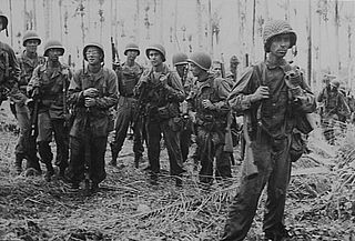
The New Guinea campaign of the Pacific War lasted from January 1942 until the end of the war in August 1945. During the initial phase in early 1942, the Empire of Japan invaded the Territory of New Guinea on 23 January and Territory of Papua on 21 July and overran western New Guinea beginning on 29 March. During the second phase, lasting from late 1942 until the Japanese surrender, the Allies—consisting primarily of Australian forces—cleared the Japanese first from Papua, then New Guinea, and finally from the Dutch colony.

<span class="mw-page-title-main">New Britain campaign</span> World War II campaign between Allied and Imperial Japanese forces

The New Britain campaign was a World War II campaign fought between Allied and Imperial Japanese forces. The campaign was initiated by the Allies in late 1943 as part of a major offensive which aimed to neutralise the important Japanese base at Rabaul, the capital of New Britain, and was conducted in two phases between December 1943 and the end of the war in August 1945.

<span class="mw-page-title-main">Battle of Cape Gloucester</span> WWII battle in the Pacific Theater

The Battle of Cape Gloucester was fought in the Pacific theater of World War II between Japanese and Allied forces on the island of New Britain, Territory of New Guinea, between 26 December 1943 and 16 January 1944. Codenamed Operation Backhander, the US landing formed part of the wider Operation Cartwheel, the main Allied strategy in the South West Pacific Area and Pacific Ocean Areas during 1943–1944. It was the second landing the US 1st Marine Division had conducted during the war thus far, after Guadalcanal. The objective of the operation was to capture the two Japanese airfields near Cape Gloucester that were defended by elements of the Japanese 17th Division.

<span class="mw-page-title-main">Battle of Arawe</span> 1943–44 WWII battle in the Pacific Theater

The Battle of Arawe was fought between Allied and Japanese forces during the New Britain campaign of World War II. The battle formed part of the Allied Operation Cartwheel and had the objective of serving as a diversion before a larger landing at Cape Gloucester in late December 1943. The Japanese military was expecting an Allied offensive in western New Britain and was reinforcing the region at the time of the Allied landing in the Arawe area on 15 December 1943. The Allies secured Arawe after about a month of intermittent fighting with the outnumbered Japanese force.

<span class="mw-page-title-main">Huon Peninsula campaign</span> Part of the New Guinea Campaign of the Pacific Theater (World War II)

The Huon Peninsula campaign was a series of battles fought in north-eastern Papua New Guinea in 1943–1944 during the Second World War. The campaign formed the initial part of an offensive that the Allies launched in the Pacific in late 1943 and resulted in the Japanese being pushed north from Lae to Sio on the northern coast of New Guinea over the course of a four-month period. For the Australians, a significant advantage was gained through the technological edge that Allied industry had achieved over the Japanese by this phase of the war, while the Japanese were hampered by a lack of supplies and reinforcements due to Allied interdiction efforts at sea and in the air.

<span class="mw-page-title-main">Admiralty Islands campaign</span> Series of WWII battles

The Admiralty Islands campaign was a series of battles in the New Guinea campaign of World War II in which the United States Army's 1st Cavalry Division took the Japanese-held Admiralty Islands.

I-177 was an Imperial Japanese Navy Kaidai-type cruiser submarine of the KD7 subclass commissioned in 1942. She served during World War II, patrolling off Australia, taking part in the New Guinea campaign, operating in the North Pacific, and participating in the Palau campaign before she was sunk by the destroyer escort USS Samuel S. Miles (DE-183) in 1944, with no survivors.

<span class="mw-page-title-main">Landing at Saidor</span> Allied amphibious landing of World War II

The landing at Saidor, codenamed Operation Michaelmas, was an Allied amphibious landing at Saidor, Papua New Guinea on 2 January 1944 as part of Operation Dexterity during World War II. In Allied hands, Saidor was a stepping stone towards Madang, the ultimate objective of General Douglas MacArthur's Huon Peninsula campaign. The capture of the airstrip at Saidor also allowed construction of an airbase to assist Allied air forces to conduct operations against Japanese bases at Wewak and Hollandia. But MacArthur's immediate objective was to cut off the 6,000 Imperial Japanese troops retreating from Sio in the face of the Australian advance from Finschhafen.

This is the order of battle of Allied and Japanese forces during the Admiralty Islands campaign of 1944.

<span class="mw-page-title-main">Engineer Special Brigade</span> Former amphibious engineer forces of the United States Army from 1942 to 1955

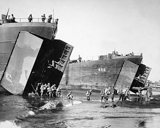
The Engineer Special Brigades were brigade-sized amphibious forces of the United States Army developed during World War II and active from 1942 to 1955. Initially designated engineer amphibian brigades, they were redesignated engineer special brigades in 1943. The 1st, 5th, and 6th Engineer Special Brigades were assigned to the European Theater of Operations. The 1st Engineer Special Brigade participated in the landings in Sicily and Italy before joining the 5th and 6th Engineer Special Brigades for the invasion of Normandy.

<span class="mw-page-title-main">Battle of Sio</span> 1943–44 New Guinea campaign phase in WWII

The Battle of Sio, fought between December 1943 and March 1944, was the break-out and pursuit phase of General Douglas MacArthur's Huon Peninsula campaign, part of the New Guinea campaign of World War II.

<span class="mw-page-title-main">Landing at Lae</span> Amphibious landing of World War II

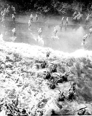
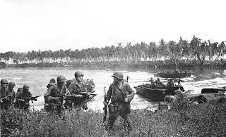
The Landing at Lae was an amphibious landing to the east of Lae and then the subsequent advance on the town during the Salamaua–Lae campaign of World War II. Part of Operation Postern, which was undertaken to capture the Japanese base at Lae, the landing was undertaken between 4 and 6 September 1943 by Australian troops from the 9th Division, supported by US naval forces from the VII Amphibious Force. The first major amphibious operation undertaken by the Australian Army since the failed Gallipoli Campaign, the Australians invested a significant amount of effort into planning the operation.

<span class="mw-page-title-main">Battle of Goodenough Island</span> Pacific battle of World War II

The Battle of Goodenough Island, also known as Operation Drake, was a battle of the Pacific campaign of World War II. The Allies landed on Goodenough Island, Papua, and clashed with a Japanese Kaigun Rikusentai. The Japanese troops had been stranded on the island during the Battle of Milne Bay in late August 1942. "Drake Force", consisting of the Australian 2/12th Battalion and attachments, landed on the southern tip of Goodenough Island at Mud Bay and Taleba Bay on 22 October, tasked with denying the Japanese use of the island prior to the Buna campaign. Following a short but intense fight, the Japanese forces withdrew to Fergusson Island on 27 October. After the battle, Goodenough Island was developed into a major Allied base for operations later in the war.

<span class="mw-page-title-main">Landing at Jacquinot Bay</span> Operation of Pacific War of World War II

The Landing at Jacquinot Bay was an Allied amphibious operation undertaken on 4 November 1944 during the New Britain Campaign of World War II. The landing was conducted as part of a change in responsibility for Allied operations on New Britain. The Australian 5th Division, under Major General Alan Ramsay, took over from the US 40th Infantry Division, which was needed for operations in the Philippines. The purpose of the operation was to establish a logistics base at Jacquinot Bay on the south coast of New Britain to support the 5th Division's planned operations near the major Japanese garrison at Rabaul.

<span class="mw-page-title-main">Landing at Scarlet Beach</span> 1943 landing in New Guinea

The Landing at Scarlet Beach took place in New Guinea during the Huon Peninsula campaign of the Second World War, involving forces from Australia, the United States and Japan. Allied forces landed at Scarlet Beach, north of Siki Cove and south of the Song River, to the east of Katika and about 10 kilometres (6.2 mi) north of Finschhafen. The capture of Finschhafen allowed the construction of air base and naval facilities to assist Allied air and naval forces to conduct operations against Japanese bases in New Guinea and New Britain.

<span class="mw-page-title-main">Battle of Finschhafen</span> 1943 battle in the Huon Peninsula campaign of WWII

The Battle of Finschhafen was part of the Huon Peninsula campaign in New Guinea during World War II and was fought between Australian and Japanese forces. The fighting took place between 22 September and 24 October 1943 following the landing at Scarlet Beach, which was followed by a two-pronged advance on Finschhafen as the Australian 20th Infantry Brigade advanced on the town from the north, while the 22nd Infantry Battalion drove from the south, having advanced from the landing beaches east of Lae. After the capture of Finschhafen, the Japanese forces in the area withdrew towards Sattelberg where they sought to hold the Australians before launching a counteroffensive, which subsequently threatened the landing beach. This attack was repelled by Australian and American forces, with heavy casualties being inflicted on the Japanese. In the aftermath, the Australians went on the offensive, capturing Sattelberg, and then advancing towards the Wareo plateau.

<span class="mw-page-title-main">2nd Engineer Brigade (United States)</span> Military unit

The 2nd Engineer Brigade was a military engineering brigade of the United States Army, that was subordinate to United States Army Alaska and had its headquarters at Fort Richardson, Alaska, prior to deactivation in 2015.

References