Laurel Canyon, Los Angeles

Last updated

Laurel Canyon, Los Angeles
Location map San Fernando Valley.png
Red pog.svg
Laurel Canyon, Los Angeles
Location within Los Angeles and San Fernando Valley
U.S. - Los Angeles Metropolitan Area location map.svg
Red pog.svg
Laurel Canyon, Los Angeles
Laurel Canyon, Los Angeles (the Los Angeles metropolitan area)
Coordinates: 34°07′02″N118°22′31″W / 34.11722°N 118.37528°W / 34.11722; -118.37528
Country Flag of the United States.svg  United States of America
State Flag of California.svg  California
County Flag of Los Angeles County, California.svg Los Angeles
City Flag of Los Angeles, California.svg Los Angeles
Named for California bay laurel
Elevation
[1]
264 m (866 ft)
Time zone UTC-8 (PST)
  Summer (DST) UTC-7 (PDT)

Laurel Canyon is a mountainous neighborhood in the Hollywood Hills region of the Santa Monica Mountains, within the Hollywood Hills West district of Los Angeles, California. The main thoroughfare of Laurel Canyon Boulevard connects the neighborhood with the more urbanized parts of Los Angeles to the north and south, between Ventura Boulevard and Hollywood Boulevard.

Contents

Originally inhabited by the Tongva people, by the early 20th century real estate developers situated a vacation site along the slope of neighboring Lookout Mountain; this formed the nucleus of what would become the Laurel Canyon neighborhood. It later developed into a celebrity enclave: the remote, rugged nature of the land and its proximity to many of the movie studios in nearby Hollywood made it an ideal location for many movie stars to site their homes, especially during the Golden Age of Hollywood. Raymond Chandler's private detective Philip Marlowe in The Long Good-bye lives in Laurel Canyon, Yucca Avenue in the early 1950s.

By the 1960s, the neighborhood had become a local center for counterculture, and many prominent folk and rock musicians moved into the area, making it a nexus for musical collaboration. By the late 1970s, criminal activity in the neighborhood, including distribution of drugs, was controlled by the Wonderland Gang (named for a Laurel Canyon thoroughfare), and the neighborhood became associated with the Wonderland murders, a grisly quadruple homicide in 1981.

Geography

Laurel Canyon is focused on its central thoroughfare, Laurel Canyon Boulevard. Unlike other nearby canyon neighborhoods, Laurel Canyon has houses lining one side of the main street most of the way up to Mulholland Drive. There are many side roads that branch off the main canyon, but most are not through streets, reinforcing the self-contained nature of the neighborhood. Some of the main side streets are Mount Olympus, Kirkwood, Wonderland Avenue, Willow Glen, and Lookout Mountain Avenue. The zip code for a portion of the neighborhood is 90046. [2]

Laurel Canyon Boulevard is an important North–South route between: West Hollywood, Hollywood, and Central Los Angeles; and Studio City and the eastern San Fernando Valley. The canyon's division between the two regions is defined by Mulholland Drive.

The Laurel Canyon neighborhood is generally bounded by West Hollywood to the west and south, Hollywood to the east, and Studio City to the north. [3]

Fauna

Laurel Canyon is known for its natural wildlife and is home to at least one adult male mountain lion. [4]

History

Tongva indigenous peoples

The Laurel Canyon area was inhabited by the Tongva people, a regional tribe of the indigenous peoples of California, for thousands of years.[ citation needed ] A spring-fed stream flowed year-round providing water.

The reliable water supply attracted colonial Spanish ranchers who started grazing sheep on the hillsides in the late 18th and early 19th centuries. After the Mexican–American War and the advent of U.S. statehood for California in 1850, the area was settled by Americans interested in water rights.

Lookout Mountain

Until the 20th century, passage up the canyon was made on foot or by mule. In 1907, an 82-mile dirt road (132 km), later named Laurel Canyon Boulevard, was built. It ran up the canyon, dividing at what is now Lookout Mountain Road; the left road went up to the summit of Lookout Mountain, and the right branch of the road went to the top of the Santa Monica Mountains and then down to the San Fernando Valley.

In 1908, the Lookout Mountain Park and Water Co. was formed to purchase 280 acres (110 ha) on Lookout Mountain, just west of Laurel Canyon, subdivided and marketed as mountain vacation properties. On August 14, 1908, the Los Angeles Times announced that the company would build Lookout Mountain Inn at the summit of Lookout Mountain and Sunset Plaza roads, and Lookout Mountain Park, Bungalow Land at Laurel Canyon Boulevard and Lookout Mountain Avenue and Wonderland Park. [5] Two years later, the company widened the winding dirt road to the top of Lookout Mountain where they built the Lookout Mountain Inn. [6] [7]

In 1910, [8] Charles Mann, a real estate developer, and Richard Shoemaker, an electrical engineer, [9] [10] built a "trackless trolley" (trolley bus) line, starting passenger service on September 11 as the first commercial trolley bus operation in the United States. [8] [11] It ran up Laurel Canyon Road from the Pacific Electric Laurel Canyon Shuttle stop at Sunset Boulevard to the Tavern at the top of Lookout Mountain Road, a road house serving visitors.

Trolley buses passing each other on Laurel Canyon Drive. The bus on the right is coasting downhill with its trolley poles down. Cyclopedia of applied electricity - a general reference work on direct-current generators and motors, storage batteries, electrochemistry, welding, electric wiring, meters, electric lighting, electric (14780081682).jpg
Trolley buses passing each other on Laurel Canyon Drive. The bus on the right is coasting downhill with its trolley poles down.

Each of the two 16-passenger cars had two trolley poles, one to a positive overhead wire and one to a ground overhead wire, and were able to sway to either side of the street, only using power uphill. Each trolley was actually an Oldsmobile bus whose gasoline engine was replaced with a 15-horsepower electric motor. [8] Their original bodies were rebuilt in 1912, [9] their open sides being enclosed. [8] Sometime in 1915, they were replaced by Stanley steam buses and the overhead wires were taken down. [9] [8] Until 1918, the shuttle service traveled up and down Laurel Canyon to meet the half hour schedule to Los Angeles. It was insufficiently patronized and discontinued when demand failed to support it after Pacific Electric stopped service to Laurel Canyon Boulevard from Gardner Junction (at Gardner Street and Sunset Boulevard, 1451 N Gardner St, West Hollywood, CA 90046) [18] [19] in 1924. [20] [21] [22]

On October 26, 1918, a fire, fanned by strong Santa Ana winds, burned about 200 acres and totally destroyed Lookout Mountain Inn at the summit of Lookout Mountain Avenue and Sunset Plaza Drive. [23] [24] [21] [22] [25] [26] [27] [22] [28] Another major fire occurred in July 1959, destroying some 38 homes. [29]

As the roads were improved, access was possible by automobile. [30] [31] [32] [33] [34] [35]

As of 2007 a vacant lot, the corner of Lookout Mountain Avenue and Laurel Canyon Blvd (2401 Laurel Canyon Blvd) [36] is where the famous 1915 "Log Cabin" mansion stood, with its 80-foot living room, floor to ceiling fireplace, bowling alley (there was no indoor swimming pool as previously stated) [37] It was once occupied by silent film star Tom Mix [38] but spent years on the rental market. In 1968 it was rented by Frank Zappa. [39] Zappa moved out after four months. The house burned to the ground on Halloween 1981. Directly across the street, at 2400 Laurel Canyon Blvd., is site of the home, long-gone, that magician Harry Houdini may have rented around 1919. It was originally the Walker estate. [40] [41]

Counterculture of the 1960s and 1970s

Laurel Canyon became a nexus of counterculture activity and attitudes in the mid-late 1960s and early 1970s, becoming famous as home to many of L.A.'s rock musicians, such as Cass Elliot of the Mamas & the Papas; Joni Mitchell; Frank Zappa; Jim Morrison of The Doors; Carole King; The Byrds; Gram Parsons; Buffalo Springfield; Canned Heat; John Mayall; members of the band The Eagles; the band Love; Neil Young; Brian Wilson of The Beach Boys as well as James Taylor, Jackson Browne, J. D. Souther, Judee Sill, Linda Ronstadt and Stone Poneys, Ned Doheny, Bonnie Raitt, Harry Nilsson; [42] and Micky Dolenz and Peter Tork of The Monkees. Cass Elliot's home was considered one of Laurel Canyon's party houses with all-night, drug-fueled sleepovers, attended by musicians and movie stars of the era. [43]

John Phillips, also of the Mamas & the Papas, took inspiration from his home in Laurel Canyon for the song "Twelve Thirty (Young Girls Are Coming to the Canyon)", released in 1967. The following year, blues artist John Mayall recorded and released the album Blues from Laurel Canyon , based on his experiences during a vacation that he spent there.

The area and its denizens served as inspiration for Joni Mitchell's third album Ladies of the Canyon , released in 1970. Her house was immortalized in the Crosby, Stills, and Nash song "Our House" (1970), written by her then-lover Graham Nash. The group is reputed to have met and first sung together in Mitchell's living room. [44] [ page needed ]

Rock photographer Henry Diltz was also a resident and used the scenic Canyon backdrop for many of his historic photos of rock musicians. Several of his photos became representations of the West Coast music scene during the 1960s and 1970s; other of his photos became album sleeve covers, such the one used for as CSN's debut album Crosby, Stills & Nash (photographed in nearby West Hollywood).

Later years

Musician Josh Tillman has said that his output under the moniker Father John Misty was partly inspired by a move to Laurel Canyon. The song "I Went to the Store One Day" from his 2015 album I Love You, Honeybear , recounts the story of how Tillman met his wife, Emma, in the parking lot of the Laurel Canyon Country Store. [45] [46]

Wonderland murders

On July 1, 1981, three members and one associate of the Wonderland Gang, so-called because they were based at 8763 Wonderland Avenue, died in the Wonderland murders (also known as the "Four on the Floor murders" or the "Laurel Canyon murders"). Salón stated "The massacre took place just down the street from what was then the home of Jerry Brown, who was California’s governor at the time. The 8763 Wonderland Avenue address itself is said to have been inhabited at one time by Paul Revere & the Raiders." [47]

See also

Related Research Articles

<span class="mw-page-title-main">San Fernando Valley</span> Valley in California, US

The San Fernando Valley, known locally as the Valley, is an urbanized valley in Los Angeles County, California. Situated to the north of the Los Angeles Basin, it contains a large portion of the city of Los Angeles, as well as several unincorporated areas; and the incorporated cities of Burbank, Calabasas, Glendale, Hidden Hills, and San Fernando. The valley is well known for its film studios such as Warner Bros. Studios and Walt Disney Studios. In addition, it is home to the Universal Studios Hollywood theme park.

<span class="mw-page-title-main">Mulholland Drive</span> Street and road in Southern California

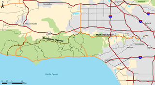
Mulholland Drive is a street and road in the eastern Santa Monica Mountains of Southern California. It is named after pioneering Los Angeles civil engineer William Mulholland. The western rural portion in Los Angeles and Ventura Counties is named Mulholland Highway. The road is featured in a significant number of films, songs, and novels. David Lynch, who wrote and directed a film named after Mulholland Drive, has said that one can feel "the history of Hollywood" on it. Jack Nicholson has lived on Mulholland Drive for many years, and still did so as of 2009.

<span class="mw-page-title-main">Studio City, Los Angeles</span> Neighborhood of Los Angeles in California, United States

Studio City is a neighborhood in the city of Los Angeles, California, in the southeast San Fernando Valley, just west of the Cahuenga Pass. It is named after the studio lot that was established in the area by film producer Mack Sennett in 1927, now known as Radford Studio Center.

<span class="mw-page-title-main">North Hollywood, Los Angeles</span> Neighborhood in Los Angeles, California, United States of America

North Hollywood is a Los Angeles, California neighborhood, located in the San Fernando Valley. The neighborhood contains the NoHo Arts District, the El Portal Theatre, several art galleries, and the Academy of TV Arts and Sciences. The North Hollywood Metro Rail station is the northern terminus of the B Line subway on the Los Angeles Metro.

<span class="mw-page-title-main">Hollywood Freeway</span> Freeway in California

The Hollywood Freeway is one of the principal freeways of Los Angeles, California and one of the busiest in the United States. It is the principal route through the Cahuenga Pass, the primary shortcut between the Los Angeles Basin and the San Fernando Valley. It is considered one of the most important freeways in the history of Los Angeles and instrumental in the development of the San Fernando Valley. It is the second oldest freeway in Los Angeles. From its southern end at the Four Level Interchange to its intersection with the Ventura Freeway in the southeastern San Fernando Valley, it is signed as part of U.S. Route 101. It is then signed as State Route 170 north to its terminus at the Golden State Freeway.

<span class="mw-page-title-main">Ventura Boulevard</span> Thoroughfare in San Fernando Valley

Ventura Boulevard is one of the primary east–west thoroughfares in the San Fernando Valley region of the City of Los Angeles, California. Ventura Boulevard is one of the oldest routes in the San Fernando Valley as it is along the commemorative route El Camino Real. It was also U.S. Route 101 (US 101) before the freeway was built, and it was also previously signed as U.S. Route 101 Business.

<span class="mw-page-title-main">Hollywood Boulevard</span> Street in Hollywood, Los Angeles, California, United States

Hollywood Boulevard is a major east–west street in Los Angeles, California. It runs through the Hollywood, East Hollywood, Little Armenia, Thai Town, and Los Feliz districts. Its western terminus is at Sunset Plaza Drive in the Hollywood Hills and its eastern terminus is at Sunset Boulevard in Los Feliz. Hollywood Boulevard is famous for running through the tourist areas in central Hollywood, including attractions such as the Hollywood Walk of Fame and the Ovation Hollywood shopping and entertainment complex.

<span class="mw-page-title-main">Hollywood Hills</span> Neighborhood in Los Angeles, California, United States

Hollywood Hills is a residential neighborhood in the central region of Los Angeles, California. It borders Studio City, Universal City and Burbank on the north, Griffith Park on the north and east, Los Feliz on the southeast, Hollywood on the south and Hollywood Hills West on the west. It includes Forest Lawn Memorial Park, Mount Sinai Memorial Park Cemetery, the Hollywood Reservoir, the Hollywood Sign, the Hollywood Bowl and the John Anson Ford Theater.

<span class="mw-page-title-main">Arroyo Seco (Los Angeles County)</span> Seasonal watercourse and human settlement in US

The Arroyo Seco, meaning "dry stream" in Spanish, is a 24.9-mile-long (40.1 km) seasonal river, canyon, watershed, and cultural area in Los Angeles County, California. The area was explored by Gaspar de Portolà who named the stream Arroyo Seco as this canyon had the least water of any he had seen. During this exploration he met the Chief Hahamog-na (Hahamonga) of the Tongva Indians.

<span class="mw-page-title-main">Ballona Creek</span> Urbanized river in Los Angeles, California, United States.

Ballona Creek is an 8.5-mile (13.7 km) channelized stream in southwestern Los Angeles County, California, United States, that was once a "year-round river lined with sycamores and willows". The urban watercourse begins in the Mid-City neighborhood of Los Angeles, flows through Culver City and Del Rey, and passes the Ballona Wetlands Ecological Preserve, the sailboat harbor Marina del Rey, and the small beachside community of Playa del Rey before draining into Santa Monica Bay. The Ballona Creek drainage basin carries water from the Santa Monica Mountains on the north, from the Baldwin Hills to the south, and as far as the Harbor Freeway (I-110) to the east.

Nichols Canyon is a residential area in the Hollywood Hills in Los Angeles, California, bounded by Hollywood Boulevard on the south and Mulholland Drive on the north, lying between Laurel Canyon and Runyon Canyon. It was also known as Miller Canyon.

<span class="mw-page-title-main">Laurel Canyon Boulevard</span>

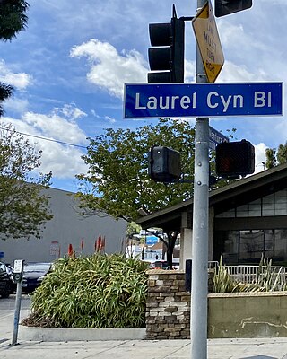
Laurel Canyon Boulevard is a major street in the city of Los Angeles. It starts off at Polk Street in Sylmar in the northern San Fernando Valley near the junction of the San Diego and the Golden State (I-5)) freeways. Laurel Canyon Boulevard bypasses the city of San Fernando to the west, running parallel to I-5 in the vicinity of Pacoima and Arleta. The portion through Sun Valley passes through rock quarries and a great deal of open space.

<span class="mw-page-title-main">Henry Diltz</span> American folk musician and photographer

Henry Stanford Diltz is an American folk musician and photographer who has been active since the 1960s.

Victory Boulevard is a major east–west arterial road that runs for 25 miles (40 km) traversing the entire length of the San Fernando Valley in Los Angeles County, California.

<span class="mw-page-title-main">Los Angeles's 2nd City Council district</span> American legislative district

Los Angeles's 2nd City Council district is one of the fifteen districts in the Los Angeles City Council. It is currently represented by Democrat Paul Krekorian since 2009, after he won the special election to finish Wendy Greuel's term.

<span class="mw-page-title-main">Hollywood Hills West, Los Angeles</span>

Hollywood Hills West is a neighborhood within Central Los Angeles, California.

<span class="mw-page-title-main">Lookout Mountain Air Force Station</span> USAF movie studio and documentary unit, 1948-1967

Lookout Mountain Air Force Station (LMAFS) is a Formerly Used Defense Site which today is a private residence of actor Jared Leto in the Laurel Canyon neighborhood of Los Angeles, California. The USAF military installation produced motion pictures and still photographs for the United States Department of Defense and the Atomic Energy Commission (AEC) from 1947 to 1969.

<span class="mw-page-title-main">Coldwater Canyon Avenue</span> Street in Los Angeles County, California, US

Coldwater Canyon Avenue is a street, primarily within the City of Los Angeles, in Los Angeles County, California. It runs 10.3 miles (16.6 km) from North Beverly Drive at Coldwater Canyon Park in Beverly Hills, north up Coldwater Canyon, including a short stretch shared with Mulholland Drive, ending at a crossroad intersection with Roscoe Boulevard in Sun Valley, where the Coldwater Canyon Avenue changes into Sheldon Street.

Wonderland Avenue Elementary School is a public elementary school in the Laurel Canyon neighborhood of Los Angeles, California. Ranked one of the best elementary schools in California, Wonderland is known for its gifted magnet program and high number of prominent parents in the entertainment industry.

<span class="mw-page-title-main">Laurel Spring</span> Water source in California

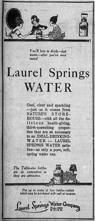
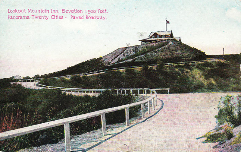
Laurel Spring, also known as Lookout Mountain Spring, is a natural spring in Laurel Canyon, Los Angeles County, California, United States, in the Hollywood Hills section of the Santa Monica Mountains. A resort property was developed at the site in the early 20th century and it was later a private residence. As of 2024, conservationists are hoping to purchase the 2.4-acre (0.97 ha) property surrounding the spring to create a protected area under the Santa Monica Mountains Recreation and Conservation Authority (MRCA).

References

  1. "Worldwide Elevation Finder". elevation.maplogs.com. Archived from the original on March 31, 2023. Retrieved January 2, 2022.
  2. "ZIP Code™ Lookup – USPS". tools.usps.com. Archived from the original on June 20, 2017. Retrieved August 15, 2015.
  3. http://planning.lacity.org/StaffRpt/InitialRpts/CPC-2017-2864.PDF Archived October 1, 2019, at the Wayback Machine [ bare URL PDF ]
  4. "Wildlife camera catches uncollared mountain lion roaming the Hollywood Hills". Los Angeles Times . October 31, 2017. Archived from the original on January 16, 2022. Retrieved January 16, 2022.
  5. Harnisch, Larry (October 6, 2014). "Mary Mallory / Hollywood Heights: Lookout Mountain Inn Promotes Real Estate". ladailymirror.com. Archived from the original on July 18, 2018. Retrieved July 18, 2018.
  6. https://cdnc.ucr.edu/cgi-bin/cdnc?a=d&d=LAH19100306.2.133.57 Archived December 9, 2017, at the Wayback Machine Los Angeles Herald, Volume 37, Number 156, March 6, 1910 "Mrs. F. J. Talamantes, accompanied by her daughters, Mrs. M. D. O'Farrell and Miss Fay Talamantes, left yesterday for a two weeks' stay at Bungalow Inn, in Laurel canyon"
  7. 1 2 3 4 5 Sebree, Mac; Ward, Paul (1973). Transit's Stepchild: The Trolley Coach. Los Angeles: Interurbans. pp. 10, 12–13. LCCN   73084356.
  8. 1 2 3 Bruce, Ashley (2017). Lombard-Gerin and Inventing the Trolleybus. Bildeston, Suffolk, UK: Trolleybooks. pp. 111–112. ISBN   978-0-904235-25-8.
  9. "Water and Power Associates". waterandpower.org. Archived from the original on July 18, 2018. Retrieved July 18, 2018.
  10. Murray, Alan (2000). World Trolleybus Encyclopaedia. Yateley, Hampshire, UK: Trolleybooks. p. 79. ISBN   0-904235-18-1.
  11. "Photo" (JPG). jpg2.lapl.org. Archived from the original on January 2, 2016. Retrieved December 8, 2017.
  12. "Index of/00018". jpg4.lapl.org. Archived from the original on December 8, 2017. Retrieved July 18, 2018.
  13. de:Datei:Trackless Trolley 00018878.jpg
  14. "Photo" (JPG). dkse.net. Archived from the original on March 31, 2023. Retrieved February 12, 2021.
  15. "Photo" (JPG). dkse.net. Archived from the original on March 27, 2019. Retrieved March 27, 2019.
  16. "Photo" (JPG). dkse.net. Archived from the original on March 27, 2019. Retrieved March 27, 2019.
  17. "Google Maps". Google Maps. Archived from the original on March 31, 2023. Retrieved December 9, 2017.
  18. "Map" (PDF). pacificelectric.org. Archived (PDF) from the original on May 8, 2018. Retrieved December 9, 2017.
  19. "Pacific Electric Hollywood Line". Electric Railway Historical Association of Southern California. Archived from the original on September 24, 2023. Retrieved March 3, 2024. Built 1894 by Cahuenga Valley Railroad Company as a narrow gauge steam line. Obtained by Pasadena & Pacific in 1896 and electrified about 1900. It was standard gauged by LAP in 1909 and became PE [Pacific Electric] property in 1911. PE operated it until March 10, 1924, when it was abandoned.
  20. 1 2 "SkyscraperPage Forum – View Single Post – noirish Los Angeles". forum.skyscraperpage.com. Archived from the original on July 18, 2018. Retrieved July 18, 2018.
  21. 1 2 3 "CityDig: Looking Back at the Lookout Mountain Inn Los Angeles Magazine". October 23, 2013. Archived from the original on December 21, 2017. Retrieved July 18, 2018.
  22. "Laurel Canyon Suite: Gods, Myths, and Fires". April 19, 2017. Archived from the original on July 18, 2018. Retrieved July 18, 2018.
  23. "SkyscraperPage Forum – View Single Post – noirish Los Angeles". forum.skyscraperpage.com. Archived from the original on July 18, 2018. Retrieved July 18, 2018.
  24. "8626 Skyline Drive – John Bertram in Laurel Canyon". October 8, 2014. Archived from the original on July 18, 2018. Retrieved July 18, 2018.
  25. "Laurel Canyon". Pinterest. Archived from the original on March 31, 2023. Retrieved July 18, 2018.
  26. "Hollywood Historic Photos". hollywoodhistoricphotos.com. Archived from the original on July 18, 2018. Retrieved July 18, 2018.
  27. "Laurel Canyon's Flammable History – Canyon News". August 27, 2010. Archived from the original on December 9, 2017. Retrieved July 18, 2018.
  28. Cecilia Rasmussen (May 11, 2007). "Looking back: Some of L.A.'s worst blazes". Los Angeles Times . Archived from the original on February 3, 2020. "Detail". martinturnbull.com. Archived from the original on December 8, 2017. Retrieved December 8, 2017.
  29. "Detail". martinturnbull.com. Archived from the original on December 8, 2017. Retrieved December 8, 2017.
  30. "Laurel Canyon". October 12, 2016. Archived from the original on March 10, 2024. Retrieved July 18, 2018.
  31. "Laurel Canyon Association: 20th Century Canyon History". Archived from the original on June 12, 2004. Retrieved July 18, 2018.
  32. "Dave McGowan on the Hippie Era and Stranger than Fiction Laurel Canyon Rock Scene – FarOutRadio.com". faroutradio.com. Archived from the original on July 18, 2018. Retrieved July 18, 2018.
  33. "8917 Appian Way – Spanish Home in Sunset Strip West". January 21, 2015. Archived from the original on July 18, 2018. Retrieved July 18, 2018.
  34. "Laurel Canyon Neighborhood Posts – Brian Ades Legacies of L.A." Brian Ades Legacies of L.A. Archived from the original on July 18, 2018. Retrieved July 18, 2018.
  35. Brown, August (August 2, 2007). "Where the rockers let their hair down". Archived from the original on May 2, 2019. Retrieved July 18, 2018 via Los Angeles Times.
  36. "Canyon News – What's that at Laurel Canyon and Lookout Mountain?". Archived from the original on November 17, 2011. Retrieved May 3, 2016.
  37. "Canyon News – Laurel Canyon House Zappa Used to Live in". Archived from the original on August 26, 2013. Retrieved May 3, 2016.
  38. "The Rock and Roll Treehouse". jackboulware.com. Archived from the original on July 18, 2018. Retrieved July 18, 2018.
  39. "Inside the Laurel Canyon Houdini Estate". wildabouthoudini.com. Archived from the original on July 18, 2018. Retrieved July 18, 2018.
  40. "Laurel Canyon Part 4". January 4, 2010. Archived from the original on July 18, 2018. Retrieved July 18, 2018.
  41. Stevens, Jenny (February 17, 2020). "'I Was a Bad Influence on the Beatles': James Taylor on Lennon, Love and Recovery". via Pocket. The Guardian. Archived from the original on March 31, 2023. Retrieved April 12, 2020.
  42. Fiegel, Eddi (September 28, 2005). Dream A Little Dream Of Me. Chicsago Review Press.
  43. Sheila Weller, Girls Like Us: Carole King, Joni Mitchell, Carly SimonAnd the Journey of a Generation, Atria Books, 2008, ISBN   0743491475.
  44. Weiner, Jonah (February 19, 2015). "The Gospel of Father John Misty". Rolling Stone. Archived from the original on March 3, 2018. Retrieved July 18, 2018.
  45. Fennessey, Sean (February 6, 2015). "The Third Revelation of Father John Misty". Grantland. Archived from the original on November 19, 2020. Retrieved July 18, 2018.
  46. Lemons, Stephen (June 9, 2000). "Return to Wonderland". Salón. Archived from the original on September 7, 2015. Retrieved August 26, 2015.

Further reading