Lava Hot Springs, Idaho

Last updated
Lava Hot Springs, Idaho
Lava Hot Springs, Idaho.jpg
Lava Hot Springs, October 2004
Bannock County Idaho Incorporated and Unincorporated areas Lava Hot Springs Highlighted 1645820.svg
Location of Lava Hot Springs in Bannock County, Idaho.
Coordinates: 42°37′10″N112°0′51″W / 42.61944°N 112.01417°W / 42.61944; -112.01417 Coordinates: 42°37′10″N112°0′51″W / 42.61944°N 112.01417°W / 42.61944; -112.01417
Country United States
State Idaho
County Bannock
Area
[1]
  Total0.72 sq mi (1.86 km2)
  Land0.69 sq mi (1.79 km2)
  Water0.03 sq mi (0.07 km2)
Elevation
5,020 ft (1,530 m)
Population
 (2010) [2]
  Total407
  Estimate 
(2019) [3]
432
  Density623.38/sq mi (240.79/km2)
Time zone UTC-7 (Mountain (MST))
  Summer (DST) UTC-6 (MDT)
ZIP code
83246
Area code(s) 208, 986
FIPS code 16-45820
GNIS feature ID0396772

Lava Hot Springs is a city along the Portneuf River in eastern Bannock County, Idaho, United States. It is part of the Pocatello, Idaho metropolitan area. The population was 407 at the 2010 census, down from 521 in 2000. Located in the mountainous valley of the Portneuf River on the old route of the Oregon Trail and California Trail, the city has become a popular resort location, noted for its numerous hot springs amenable to bathing and a turbulent inner tube run through part of the town.

Contents

Geography

Lava Hot Springs is located at 42°37′10″N112°0′51″W / 42.61944°N 112.01417°W / 42.61944; -112.01417 (42.619482, -112.014283), [4] at an elevation of 5,020 feet (1,530 m) above sea level.

According to the United States Census Bureau, the city has a total area of 0.71 square miles (1.84 km2), of which, 0.68 square miles (1.76 km2) is land and 0.03 square miles (0.08 km2) is water. [5]

Demographics

Historical population
CensusPop.
1920 662
1930 544−17.8%
1940 64718.9%
1950 591−8.7%
1960 5930.3%
1970 516−13.0%
1980 467−9.5%
1990 420−10.1%
2000 52124.0%
2010 407−21.9%
2019 (est.)432 [3] 6.1%
U.S. Decennial Census [6]

2010 census

At the 2010 census there were 407 people in 209 households, including 104 families, in the city. The population density was 598.5 inhabitants per square mile (231.1/km2). There were 317 housing units at an average density of 466.2 per square mile (180.0/km2). The racial makeup of the city was 97.5% White, 0.2% African American, 0.2% Native American, 1.2% from other races, and 0.7% from two or more races. Hispanic or Latino of any race were 4.2%. [2]

Of the 209 households 16.3% had children under the age of 18 living with them, 40.2% were married couples living together, 8.1% had a female householder with no husband present, 1.4% had a male householder with no wife present, and 50.2% were non-families. 44.5% of households were one person and 20.6% were one person aged 65 or older. The average household size was 1.95 and the average family size was 2.74.

The median age was 50.9 years. 16.7% of residents were under the age of 18; 6.2% were between the ages of 18 and 24; 19.2% were from 25 to 44; 31.4% were from 45 to 64; and 26.5% were 65 or older. The gender makeup of the city was 48.2% male and 51.8% female.

2000 census

At the 2000 census there were 521 people in 232 households, including 125 families, in the city. The population density was 730.7 inhabitants per square mile (282.1/km2). There were 309 housing units at an average density of 433.4 per square mile (167.3/km2). The racial makeup of the city was 96.93% White, 1.15% Native American, 0.19% Asian, 1.34% from other races, and 0.38% from two or more races. Hispanic or Latino of any race were 2.30%. [7]

Of the 232 households 24.1% had children under the age of 18 living with them, 41.8% were married couples living together, 7.8% had a female householder with no husband present, and 45.7% were non-families. 39.7% of households were one person and 19.0% were one person aged 65 or older. The average household size was 2.23 and the average family size was 3.06.

The age distribution was 27.4% under the age of 18, 5.2% from 18 to 24, 26.7% from 25 to 44, 21.9% from 45 to 64, and 18.8% 65 or older. The median age was 40 years. For every 100 females, there were 98.9 males. For every 100 females age 18 and over, there were 97.9 males.

The median household income was $23,472 and the median family income was $38,750. Males had a median income of $38,125 versus $20,313 for females. The per capita income for the city was $16,242. About 16.7% of families and 25.1% of the population were below the poverty line, including 33.6% of those under age 18 and 10.5% of those age 65 or over.

Transportation

West along Main Street in Lava Hot Springs, July 2003 Down Main Street - panoramio.jpg
West along Main Street in Lava Hot Springs, July 2003

The primary road through the city is U.S. Route 30 (US 30), which passes just north of the majority of the community. On the northeast corner of the city is the western end of Old Highway 30, which is a former routing of US 30 that runs parallel to and just south of the Union Pacific Railroad (UP) tracks (formerly Oregon Short Line) [8] around the north end of the Fish Creek Range. The current routing of US 30 via Fish Creek Summit reduced the distance between Lava Hot Springs and Soda Springs by about 11 miles (18 km), but bypassed the city of Bancroft. Notwithstanding, the rerouting still created a more direct route between Lava Hot Springs and Bancroft (via Central Road), reducing driving distance between the cities by about 5.5 miles (8.9 km). [9]

Notable people

See also

Related Research Articles

<span class="mw-page-title-main">Minidoka County, Idaho</span> County in Idaho, United States

Minidoka County is a county located in the U.S. state of Idaho. As of the 2020 census, the population was 21,613. The county seat and largest city is Rupert.

<span class="mw-page-title-main">Bannock County, Idaho</span> County in Idaho, United States

Bannock County is a county in the southeastern part of Idaho. As of the 2020 Census, the population was 87,018, making it the sixth-most populous county in Idaho. The county seat and largest city is Pocatello. The county was established in 1893 and named after the local Bannock tribe. It is one of the counties with territories included in the Fort Hall Indian Reservation of the federally recognized Shoshone-Bannock Tribes.

<span class="mw-page-title-main">Oakhaven, Arkansas</span> Town in Arkansas, United States

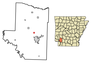
Oakhaven is a town in Hempstead County, Arkansas, United States. The population was 63 at the 2010 census. It is part of the Hope Micropolitan Statistical Area.

<span class="mw-page-title-main">Ferndale, Florida</span> Census-designated place in Florida

Ferndale is a census-designated place (CDP) in Lake County, Florida, United States. The population was 472 at the 2010 census, up from 233 at the 2000 census. It is part of the Orlando–Kissimmee Metropolitan Statistical Area.

<span class="mw-page-title-main">Lake Kathryn, Florida</span> Census-designated place in Florida

Lake Kathryn is a census-designated place (CDP) in Lake County, Florida, United States. The population was 920 at the 2010 census. The area is also known as Lake Kathryn Heights. It is part of the Orlando–Kissimmee Metropolitan Statistical Area.

<span class="mw-page-title-main">Eagle, Idaho</span> City in Idaho, United States

Eagle is a city in Ada County, Idaho, 10 miles northwest of Boise. The population was 30,346 at the time of the 2020 census.

<span class="mw-page-title-main">McCammon, Idaho</span> City in Idaho, United States

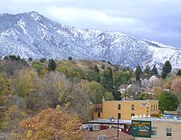
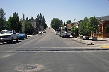
McCammon is a city in Bannock County, Idaho, United States. It is part of the Pocatello, Idaho Metropolitan Statistical Area'. The population was 809 at the 2010 census.

<span class="mw-page-title-main">Carey, Idaho</span> City in Idaho, United States

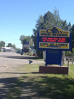
Carey is a city in Blaine County, Idaho, United States. The population was 604 at the 2010 census. Carey is primarily an agricultural city and is the location of the Blaine County Fairgrounds. Nearby recreational destinations include the Craters of the Moon National Monument, Carey Lake, Silver Creek and the Little Wood River. Further west is the Big Wood River Valley, leading to the Sun Valley resort. In recent years, the city of Carey has experienced significant growth.

<span class="mw-page-title-main">Arco, Idaho</span> City in Idaho, United States

Arco is a city in Butte County, Idaho, United States. The population was 879 as of the 2020 United States census, down from 995 at the 2010 census. Arco is the county seat and largest city in Butte County.

<span class="mw-page-title-main">Grace, Idaho</span> City in Idaho, United States

Grace is a city in Caribou County, Idaho, United States. The population was 915 at the 2010 census.

<span class="mw-page-title-main">Soda Springs, Idaho</span> City in Idaho, United States

Soda Springs is a city in Caribou County, Idaho, United States. Its population was 3,058 at the time of the 2010 census. The city has been the county seat of Caribou County since the county was organized in 1919. In the 1860s, Soda Springs served as the seat of Oneida County.

<span class="mw-page-title-main">Hagerman, Idaho</span> City in Idaho, United States

Hagerman is a city in Gooding County, Idaho, United States. The population was 872 at the 2010 census, up from 656 in 2000. The area is noted for its fossil beds and the Thousand Springs of the Eastern Snake Plain Aquifer. Hagerman is home to a national fish hatchery, a university research station, and extensive aquaculture, assisted by an abundance of geothermal water for temperature regulation.

<span class="mw-page-title-main">Riggins, Idaho</span> City in Idaho, United States

Riggins is a city in the western United States in Idaho County, Idaho. Nestled deep in a canyon at the confluence of the Salmon and Little Salmon rivers in west central Idaho, it is approximately 150 highway miles (240 km) north of Boise, and 120 highway miles (190 km) south-southeast of Lewiston. The elevation is 1,821 feet (555 m) above sea level, and its population was 419 at the 2010 census.

<span class="mw-page-title-main">Shoshone, Idaho</span> City in Idaho, United States

Shoshone is the county seat and largest city of Lincoln County, Idaho, United States. The population was 1,461 at the 2010 census. In contrast to the Shoshone Native American tribe for which it is named, the city's name is correctly pronounced "Show-shown", with a silent "e".

<span class="mw-page-title-main">Cambridge, Idaho</span> City in Idaho, United States

Cambridge is a city in Washington County, Idaho, United States. The population was 328 at the 2010 census, down from 360 in 2000. It is the second largest city in the county, behind the significantly larger Weiser, the county seat.

<span class="mw-page-title-main">Conway, Iowa</span> City in Iowa, United States

Conway is a city in Taylor County, Iowa, United States. The population was 17 at the 2020 census.

<span class="mw-page-title-main">Fruitland, Maryland</span> City in Maryland, United States

Fruitland is a city in Wicomico County, Maryland, United States. The population was 4,866 at the 2010 census. It is included in the Salisbury, Maryland-Delaware Metropolitan Statistical Area.

<span class="mw-page-title-main">Beclabito, New Mexico</span> Census-designated place in San Juan County, New Mexico, United States

Beclabito is a census-designated place (CDP) in San Juan County, New Mexico, United States. The population was 317 at the 2010 census. It is part of the Farmington Metropolitan Statistical Area.

<span class="mw-page-title-main">Knollwood, Texas</span> City in Texas, United States

Knollwood is a city in Grayson County, Texas, United States. The population was 432 at the 2010 census. It is part of the Sherman–Denison metropolitan statistical area.

Effie is an unorganized territory in Itasca County, Minnesota, United States. The population was 203 at the 2010 census.

References

  1. "2019 U.S. Gazetteer Files". United States Census Bureau. Retrieved July 9, 2020.
  2. 1 2 "U.S. Census website". United States Census Bureau . Retrieved 2012-12-18.
  3. 1 2 "Population and Housing Unit Estimates". United States Census Bureau. May 24, 2020. Retrieved May 27, 2020.
  4. "US Gazetteer files: 2010, 2000, and 1990". United States Census Bureau. 2011-02-12. Retrieved 2011-04-23.
  5. "US Gazetteer files 2010". United States Census Bureau. Archived from the original on 2012-07-02. Retrieved 2012-12-18.
  6. "Census of Population and Housing". Census.gov. Retrieved June 4, 2015.
  7. "U.S. Census website". United States Census Bureau . Retrieved 2008-01-31.
  8. Bancroft (Map). 1:62,500. United States Geological Survey. 1949. Retrieved September 21, 2022.
  9. Google (September 21, 2022). "Old Hwy 30, Bancroft, ID 83217" (Map). Google Maps . Google. Retrieved September 21, 2022.