
Worlds End State Park is a 780-acre (316 ha) Pennsylvania state park in Sullivan County, Pennsylvania. The park, nearly surrounded by Loyalsock State Forest, is in the Loyalsock Creek valley on Pennsylvania Route 154 in Forks and Shrewsbury Townships southeast of the borough of Forksville. The name Worlds End has been used since at least 1872, but its origins are uncertain. Although it was founded as Worlds End State Forest Park by Governor Gifford Pinchot in 1932, the park was officially known as Whirls End State Forest Park from 1936 to 1943.

Larrys Creek is a 22.9-mile-long (36.9 km) tributary of the West Branch Susquehanna River in Lycoming County in the U.S. state of Pennsylvania. A part of the Chesapeake Bay drainage basin, its watershed drains 89.1 square miles (231 km2) in six townships and a borough. The creek flows south from the dissected Allegheny Plateau to the Ridge-and-valley Appalachians through sandstone, limestone, and shale from the Devonian, Mississippian, and Pennsylvanian periods.
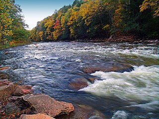
Pine Creek is a tributary of the West Branch Susquehanna River in Potter, Tioga, Lycoming, and Clinton counties in Pennsylvania. The creek is 87.2 miles (140.3 km) long. Within Tioga County, 23.25 miles (37.42 km) of Pine Creek are designated as a Pennsylvania Scenic River.

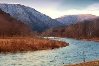
Loyalsock Creek is a 64-mile-long (103 km) tributary of the West Branch Susquehanna River located chiefly in Sullivan and Lycoming counties in Pennsylvania in the United States. As the crow flies, Lycoming County is about 130 miles (209 km) northwest of Philadelphia and 165 miles (266 km) east-northeast of Pittsburgh.

White Deer Hole Creek is a 20.5-mile (33.0 km) tributary of the West Branch Susquehanna River in Clinton, Lycoming and Union counties in the U.S. state of Pennsylvania. A part of the Chesapeake Bay drainage basin, the White Deer Hole Creek watershed drains parts of ten townships. The creek flows east in a valley of the Ridge-and-valley Appalachians, through sandstone, limestone, and shale from the Ordovician, Silurian, and Devonian periods.

Tioga State Forest is a Pennsylvania State Forest in District #16, in the Allegheny Plateau region within Tioga County, Pennsylvania.
Loyalsock State Forest is a Pennsylvania state forest in Pennsylvania Bureau of Forestry District #20. The forest spans across the northern tier's "Endless Mountains" and is a total of 114,552 acres (46,358 ha). The Loyalsock is a “working forest” and is managed for pure water, recreation, plant and animal habitats, sustainable timber, and natural gas.

Little Pine State Park is a Pennsylvania state park on 2,158 acres (873 ha) in Cummings Township, Lycoming County, Pennsylvania in the United States. Little Pine State park is along 4.2 miles (6.8 km) of Little Pine Creek, a tributary of Pine Creek, in the midst of the Tiadaghton State Forest. A dam on the creek has created a lake covering 94 acres (38 ha) for fishing, boating, and swimming. The park is on Pennsylvania Route 4001, 4 miles (6.4 km) northeast of the unincorporated village of Waterville or 8 miles (13 km) southwest of the village of English Center. The nearest borough is Jersey Shore, Pennsylvania, about 15 miles (24 km) south at the mouth of Pine Creek on the West Branch Susquehanna River.

Upper Pine Bottom State Park is a 5-acre (2.0 ha) Pennsylvania state park in Lycoming County, Pennsylvania in the United States. The park is in Cummings Township on Pennsylvania Route 44 and is surrounded by the Tiadaghton State Forest. It is on Upper Pine Bottom Run, which gave the park its name and is a tributary of Pine Creek. Upper Pine Bottom State Park is in the Pine Creek Gorge, where the streams have cut through five major rock formations from the Devonian and Carboniferous periods.
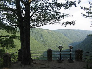
Colton Point State Park is a 368-acre (149 ha) Pennsylvania state park in Tioga County, Pennsylvania, in the United States. It is on the west side of the Pine Creek Gorge, also known as the Grand Canyon of Pennsylvania, which is 800 feet (240 m) deep and nearly 4,000 feet (1,200 m) across at this location. The park extends from the creek in the bottom of the gorge up to the rim and across part of the plateau to the west. Colton Point State Park is known for its views of the Pine Creek Gorge, and offers opportunities for picnicking, hiking, fishing and hunting, whitewater boating, and camping. Colton Point is surrounded by Tioga State Forest and its sister park, Leonard Harrison State Park, on the east rim. The park is on a state forest road in Shippen Township 5 miles (8 km) south of U.S. Route 6.

Leonard Harrison State Park is a 585-acre (237 ha) Pennsylvania state park in Tioga County, Pennsylvania, in the United States. It is on the east rim of the Pine Creek Gorge, also known as the Grand Canyon of Pennsylvania, which is 800 feet (240 m) deep and nearly 4,000 feet (1,200 m) across here. It also serves as headquarters for the adjoining Colton Point State Park, its sister park on the west rim of the gorge. Leonard Harrison State Park is known for its views of the Pine Creek Gorge, and offers hiking, fishing and hunting, whitewater boating, and camping. The park is in Shippen and Delmar Townships, 10 miles (16 km) west of Wellsboro at the western terminus of Pennsylvania Route 660.

Lyman Run State Park is a 595-acre (241 ha) Pennsylvania state park in Ulysses and West Branch Townships in Potter County, Pennsylvania in the United States. Lyman Run Lake is a 45-acre (18 ha) man-made lake within the park, surrounded by a northern hardwood forest of mainly maple and cherry trees. Lyman Run State Park is 7 miles (11 km) west of Galeton and 15 miles (24 km) east of Coudersport, and is nearly completely surrounded by the Susquehannock State Forest.
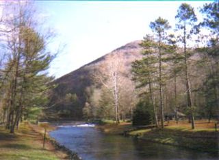
Ole Bull State Park is a 132-acre (53 ha) Pennsylvania state park in Stewardson Township, Potter County, Pennsylvania in the United States. The park is located on Pennsylvania Route 144, 26 miles (42 km) north of Renovo and 18 miles (29 km) south of Galeton. Ole Bull State Park is in the Kettle Creek Valley, and is surrounded by Susquehannock State Forest. The woods surrounding the park are called the Black Forest because of its once dense tree cover.

Hyner Run State Park is a 180-acre (73 ha) Pennsylvania state park in Chapman Township, Clinton County, Pennsylvania in the United States. The park is 6 miles (9.7 km) east of Renovo and 3 miles (5 km) north of Hyner on Pennsylvania Route 120. Hyner Run State Park is surrounded by Sproul State Forest.

The Pennsylvania Lumber Museum is near Galeton, Potter County, Pennsylvania in the United States. It documents the history and technology of the lumber industry that was a vital part of the economic development and ecological destruction of Pennsylvania.

Plunketts Creek is an approximately 6.2-mile-long (10 km) tributary of Loyalsock Creek in Lycoming and Sullivan counties in the U.S. state of Pennsylvania. Two unincorporated villages and a hamlet are on the creek, and its watershed drains 23.6 square miles (61 km2) in parts of five townships. The creek is a part of the Chesapeake Bay drainage basin via Loyalsock Creek and the West Branch Susquehanna and Susquehanna Rivers.

The Pine Creek Rail Trail is the only rail trail in the Appalachian Mountains of north-central Pennsylvania.
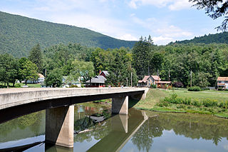
Cedar Run is an unincorporated community in Brown Township, Lycoming County, Pennsylvania, United States. Cedar Run, a stream with the same name as the community, enters Pine Creek at Cedar Run, in the Pine Creek Gorge. The stream is one of a half-dozen tributaries entering from the western side of Pine Creek, along with nearby Slate Run. The Pine Creek Rail Trail passes through Cedar Run. The village is linked to Pennsylvania Route 414 by a spur road crossing a bridge over Pine Creek.

Pine Creek Gorge, sometimes called The Grand Canyon of Pennsylvania, is a 47-mile (76 km) gorge carved into the Allegheny Plateau by Pine Creek in north-central Pennsylvania.

Slate Run is an unincorporated community in Brown Township, Lycoming County, in the U.S. state of Pennsylvania. It lies between Blackwell and Waterville along Pennsylvania Route 414. Slate Run, a stream with the same name as the community, enters Pine Creek at Slate Run, in the Pine Creek Gorge. The Pine Creek Rail Trail passes through the village.


