Blossburg, Pennsylvania

Last updated
Blossburg, Pennsylvania
Blossburg Castle.jpg
Blossburg's "castle"
Tioga County Pennsylvania Incorporated and Unincorporated areas Blossburg Highlighted.svg
Location of Blossburg in Tioga County, Pennsylvania.
USA Pennsylvania location map.svg
Red pog.svg
Blossburg
Location within the U.S. state of Pennsylvania
Usa edcp location map.svg
Red pog.svg
Blossburg
Blossburg (the United States)
Coordinates: 41°40′43″N77°03′48″W / 41.67861°N 77.06333°W / 41.67861; -77.06333
Country United States
State Pennsylvania
County Tioga
Settled1802
Incorporated (borough)1871
Area
[1]
  Total4.65 sq mi (12.03 km2)
  Land4.65 sq mi (12.03 km2)
  Water0.00 sq mi (0.00 km2)
Elevation
1,342 ft (409 m)
Population
 (2020) [2]
  Total1,533
  Density329.96/sq mi (127.39/km2)
Time zone Eastern (EST)
  Summer (DST)EDT
ZIP code
16912
Area code 570
FIPS code 42-07160
Website Blossburg Community Website

Blossburg is a borough in Tioga County, Pennsylvania, United States. The population was 1,536 at the 2020 census. [3]

Contents

History

In 1792, a party of immigrants who were building the Williamson Road from Williamsport, in Lycoming County, to Painted Post in New York, under the leadership of Robert and Benjamin Patterson, discovered coal within the present town limits of Blossburg. When the group reached the Tioga River, they established a supply camp at its banks.

In 1801, Aaron Bloss moved to Tioga County. In 1802, he settled at the area known as "Peter’s Camp". He is considered the first settler of Blossburg. Sometime between 1818 and 1820, Bloss made the first attempt to found a town, changing the name of Peter's Camp to Blossburg. Blossburg was finally recognized and incorporated a borough in August 1871.

Shortly after 1810, David Clemens made the first effort to mine and market coal from this area. Clemens opened a mine on Bear Run between 1812 and 1815, serving only the Painted Post area. Around the same time, a lower vein was opened on Bear Run by Aaron Bloss. This vein is known as the Bloss Vein; it also was used to satisfy local demands.

The first efforts to market and ship coal out of this area were on a small scale, due to the poor road conditions and the poor navigability of the Tioga River. In 1817, a coalition of Bloss and the other miners asked the legislature for funds to improve these routes. In the meantime, Blossburg coal was being shipped to Painted Post, Elmira, and Corning in western New York.

More important than the local runs, Blossburg coal was being shipped to the state capital at Albany. The legislature passed bills to support the construction of railroads and improve canal navigation in order to support the transport of coal. Blossburg coal was also shipped to Philadelphia, where it attracted the notice of enterprising businessmen.

In 1826, Judge John H. Knapp erected an iron ore smelting works within the borough limits of Blossburg. Knapp also opened coal mines on Coal Run and ore mines on "Barney Hill".

In July 1840, the railroadwas constructed through Covington from Corning, and was opened for locomotives to Blossburg in September. This railroad allowed the mines to be tapped and for their coal to be easily distributed through the Twin Tiers.

For more than 150 years, coal has played a vital role in the development of Blossburg. Today many of the existing mines are dormant. But Ward Manufacturing is a descendant of the Blossburg coal mining industry and is the largest business operating in the Blossburg area.

On June 23, 1967, Mohawk Airlines Flight 40 crashed outside of Blossburg with the loss of all 34 passengers and crew. Flight 40 was a regularly scheduled passenger flight between Elmira, New York and Washington, DC. The aircraft was a BAC 1-11-204AF.

Geography

Blossburg is located at 41°40′39″N77°3′56″W / 41.67750°N 77.06556°W / 41.67750; -77.06556 (41.677615, -77.065519). [4] According to the U.S. Census Bureau, the borough has a total area of 4.8 square miles (12 km2), all land.

Demographics

Historical population
CensusPop.Note
1880 2,146
1890 2,56819.7%
1900 2,423−5.6%
1910 2,303−5.0%
1920 2,033−11.7%
1930 1,696−16.6%
1940 1,95515.3%
1950 1,954−0.1%
1960 1,9560.1%
1970 1,753−10.4%
1980 1,7570.2%
1990 1,571−10.6%
2000 1,480−5.8%
2010 1,5383.9%
2020 1,533−0.3%
Sources: [5] [6] [7] [2]

As of the census [6] of 2000, there were 1,480 people, 647 households, and 390 families residing in the borough. The population density was 311.8 inhabitants per square mile (120.4/km2). There were 694 housing units at an average density of 146.2 per square mile (56.4/km2). The racial makeup of the borough was 99.05% White, 0.27% African American, 0.14% Native American, 0.07% Asian, 0.14% from other races, and 0.34% from two or more races. Hispanic or Latino of any race were 0.54% of the population.

There were 647 households, out of which 26.7% had children under the age of 18 living with them, 46.5% were married couples living together, 9.7% had a female householder with no husband present, and 39.6% were non-families. 35.4% of all households were made up of individuals, and 21.9% had someone living alone who was 65 years of age or older. The average household size was 2.23 and the average family size was 2.88.

In the borough the population was spread out, with 24.7% under the age of 18, 6.5% from 18 to 24, 23.9% from 25 to 44, 23.2% from 45 to 64, and 21.8% who were 65 years of age or older. The median age was 41 years. For every 100 females there were 92.5 males. For every 100 females age 18 and over, there were 85.5 males.

The median income for a household in the borough was $29,449, and the median income for a family was $41,563. Males had a median income of $27,625 versus $21,133 for females. The per capita income for the borough was $17,375. About 7.0% of families and 12.8% of the population were below the poverty line, including 14.7% of those under age 18 and 9.6% of those age 65 or over.

Notable people

Related Research Articles

<span class="mw-page-title-main">Tioga County, Pennsylvania</span> County in Pennsylvania, United States

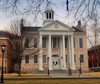
Tioga County is a county in the Commonwealth of Pennsylvania. As of the 2020 census, the population was 41,045. Its county seat is Wellsboro. The county was created on March 26, 1804, from part of Lycoming County and later organized in 1812. It is named for the Tioga River. Tioga County is in the sparsely populated Pennsylvania Wilds region.

<span class="mw-page-title-main">South Renovo, Pennsylvania</span> Borough in Pennsylvania, United States

South Renovo is a borough in Clinton County, Pennsylvania, United States, located on the West Branch Susquehanna River, directly across from Renovo. The population was 439 at the 2010 census, down from 557 in 2000.

<span class="mw-page-title-main">Bloss Township, Pennsylvania</span> Township in Pennsylvania, United States

Bloss Township is a township in Tioga County, Pennsylvania, United States. The population was 344 at the 2020 census.

<span class="mw-page-title-main">Charleston Township, Tioga County, Pennsylvania</span> Township in Pennsylvania, United States

Charleston Township is a township in Tioga County, Pennsylvania, United States. The population was 3,562 at the 2020 census. Hills Creek State Park, one of 120 Pennsylvania state parks, is in Charleston Township.

<span class="mw-page-title-main">Delmar Township, Tioga County, Pennsylvania</span> Township in Pennsylvania, United States

Delmar Township is a township in Tioga County, Pennsylvania, United States. The population was 2,796 at the 2020 census.

<span class="mw-page-title-main">Duncan Township, Tioga County, Pennsylvania</span> Township in Pennsylvania, United States

Duncan Township is a township in Tioga County, Pennsylvania, United States. The population was 188 at the 2020 census.

<span class="mw-page-title-main">Hamilton Township, Tioga County, Pennsylvania</span> Township in Pennsylvania, United States

Hamilton Township is a township in Tioga County, Pennsylvania, United States. The population was 534 at the 2020 census.

<span class="mw-page-title-main">Knoxville, Pennsylvania</span> Borough in Pennsylvania, United States

Knoxville is a borough in northwestern Tioga County, Pennsylvania, United States. The population was 682 at the time of the 2020 census.

<span class="mw-page-title-main">Lawrenceville, Pennsylvania</span> Borough in Pennsylvania, United States

Lawrenceville is a borough in Tioga County, Pennsylvania. The population was 690 at the 2020 census.

<span class="mw-page-title-main">Liberty, Tioga County, Pennsylvania</span> Borough in Pennsylvania, United States

Liberty is a small borough in Tioga County, Pennsylvania, United States. The population was 232 at the time of the 2020 census.

<span class="mw-page-title-main">Liberty Township, Tioga County, Pennsylvania</span> Township in Pennsylvania, United States

Liberty Township is a township in Tioga County, Pennsylvania, United States. The population was 1,037 at the 2020 census.

<span class="mw-page-title-main">Mansfield, Pennsylvania</span> Borough in Pennsylvania, United States

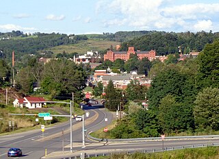
Mansfield is a borough located in east-central Tioga County, Pennsylvania, United States, in the Tioga River valley. It is situated at the intersection of U.S. Route 6 and U.S. Business Route 15, about 36 miles (58 km) southwest of Elmira, New York.

<span class="mw-page-title-main">Morris Township, Tioga County, Pennsylvania</span> Township in Pennsylvania, United States

Morris Township is a township in Tioga County, Pennsylvania, United States. The population was 562 at the 2020 census.

<span class="mw-page-title-main">Richmond Township, Tioga County, Pennsylvania</span> Township in Pennsylvania, United States

Richmond Township is a township in Tioga County, Pennsylvania, United States. The population was 2,164 at the 2020 census.

<span class="mw-page-title-main">Roseville, Pennsylvania</span> Borough in Pennsylvania, United States

Roseville is a borough in Tioga County, Pennsylvania, United States. The population was 177 at the 2020 census.

<span class="mw-page-title-main">Rutland Township, Pennsylvania</span> Township in Pennsylvania, United States

Rutland Township is a township in Tioga County, Pennsylvania, United States. The population was 776 at the 2020 census.

<span class="mw-page-title-main">Tioga, Pennsylvania</span> Borough in Pennsylvania, United States

Tioga is a borough in Tioga County, Pennsylvania, United States. The population was 611 at the 2010 census. It is located north of Tioga and Hammond Lakes along the Tioga River.

<span class="mw-page-title-main">Tioga Township, Tioga County, Pennsylvania</span> Township in Pennsylvania, United States

Tioga Township is a township in Tioga County, Pennsylvania, United States. The population was 941 at the 2020 census.

<span class="mw-page-title-main">Wellsboro, Pennsylvania</span> Borough in Pennsylvania, United States

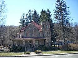
Wellsboro is a borough in Tioga County, Pennsylvania. The borough was founded by Benjamin Wistar Morris. It is located 52 miles (84 km) northwest of Williamsport. The population was 3,472 at the 2020 census.

<span class="mw-page-title-main">Southern Tioga School District</span> School district in Pennsylvania

Southern Tioga School District is a small, rural public school system located in northern Central Pennsylvania covering parts of Tioga County and Lycoming County. It encompasses 485 square miles (1,260 km2). According to 2010 federal census data, it serves a resident population of 15,551 making it a third class school district. The district operates schools in Mansfield, Liberty, and Blossburg. It serves residents in: Covington Township, Rutland Township, Richmond Township, Liberty Township, Bloss Township, Sullivan Township, Ward Township, Morris Township, and Hamilton Township, as well as Roseville Borough and Putnam. In Lycoming County, Southern Tioga School District serves both: Jackson Township and Cogan House Township.

References

  1. "ArcGIS REST Services Directory". United States Census Bureau. Retrieved October 12, 2022.
  2. 1 2 "Census Population API". United States Census Bureau. Retrieved Oct 12, 2022.
  3. Bureau, US Census. "City and Town Population Totals: 2020-2021". Census.gov. US Census Bureau. Retrieved 16 July 2022.
  4. "US Gazetteer files: 2010, 2000, and 1990". United States Census Bureau. 2011-02-12. Retrieved 2011-04-23.
  5. "Census of Population and Housing". U.S. Census Bureau. Retrieved 11 December 2013.
  6. 1 2 "U.S. Census website". United States Census Bureau . Retrieved 2008-01-31.
  7. "Incorporated Places and Minor Civil Divisions Datasets: Subcounty Resident Population Estimates: April 1, 2010 to July 1, 2012". Population Estimates. U.S. Census Bureau. Archived from the original on 11 June 2013. Retrieved 11 December 2013.
  8. Reunion of the Society of the Army of the Cumberland (1914). Reunion of the Society of the Army of the Cumberland: Forty-first Reunion. Chattanooga, TN: MacGowan–Cooke Printing Company. p. 115 via Google Books.
  9. Jones, David A. (December 14, 2008). "William Bauchop Wilson First U.S. Secretary of Labor". Blossburg.org. Blossburg, PA: Town of Blossburg. Retrieved June 22, 2022.