Putnam Township, Pennsylvania

Last updated

Putnam Township,
Pennsylvania
Township
Putnam Township Old Route 15.jpg
Looking south on Old Route 15 in Putnam Township
Map of Tioga County Pennsylvania Highlighting Putnam Township.PNG
Map of Tioga County Highlighting Putnam Township
Map of Pennsylvania highlighting Tioga County.svg
Map of Pennsylvania highlighting Tioga County
Country United States
State Pennsylvania
County Tioga
Settled1801
Incorporated1892
Area
[1]
  Total0.60 sq mi (1.55 km2)
  Land0.60 sq mi (1.55 km2)
  Water0.00 sq mi (0.00 km2)
Population
 (2020) [2]
  Total401 Decrease2.svg
  Estimate 
(2021) [2]
399
  Density692.82/sq mi (267.50/km2)
Time zone Eastern Time Zone (North America)
  Summer (DST)EDT
FIPS code 42-117-62960
Historical population
CensusPop.Note
2000 428
2010 425−0.7%
2020 401−5.6%
2021 (est.)399 [2] −0.5%
U.S. Decennial Census [3]

Putnam Township is a township in Tioga County, Pennsylvania, United States. The population was 401 at the 2020 census. [2] Putnam Township is the village of Covington. Covington was formerly a borough that chose to become a township in 1892. It was settled in 1801.

Contents

Geography

According to the United States Census Bureau, the township has a total area of 0.6 square mile (1.6 km2), all land.

Putnam Township is surrounded by Covington Township.

Demographics

As of the census [4] of 2000, there were 428 people, 174 households, and 116 families residing in the township. The population density was 681.9 inhabitants per square mile (263.3/km2). There were 188 housing units at an average density of 299.5 per square mile (115.6/km2). The racial makeup of the township was 99.53% White, 0.23% Native American, and 0.23% from two or more races. Hispanic or Latino of any race were 0.47% of the population.

There were 174 households, out of which 31.6% had children under the age of 18 living with them, 54.6% were married couples living together, 9.8% had a female householder with no husband present, and 32.8% were non-families. 28.2% of all households were made up of individuals, and 10.3% had someone living alone who was 65 years of age or older. The average household size was 2.46 and the average family size was 3.02.

In the township the population was spread out, with 25.7% under the age of 18, 7.9% from 18 to 24, 30.8% from 25 to 44, 20.6% from 45 to 64, and 15.0% who were 65 years of age or older. The median age was 36 years. For every 100 females, there were 88.5 males. For every 100 females age 18 and over, there were 92.7 males.

The median income for a household in the township was $26,800, and the median income for a family was $32,083. Males had a median income of $24,038 versus $20,278 for females. The per capita income for the township was $14,349. About 3.4% of families and 8.4% of the population were below the poverty line, including 6.2% of those under age 18 and 3.4% of those age 65 or over.

Community

Related Research Articles

<span class="mw-page-title-main">East Brooklyn, Connecticut</span> Census-designated place in Connecticut, United States

East Brooklyn is a census-designated place (CDP) located within the town of Brooklyn in Windham County, Connecticut. It is the portion of the Danielson urban cluster within the town of Brooklyn. The population was 2,205 at the 2020 census. US 6 runs through the town and severs the town.

<span class="mw-page-title-main">Kinderhook Township, Michigan</span> Civil township in Michigan, United States

Kinderhook Township is a civil township of Branch County in the U.S. state of Michigan. As of the 2020 census, the township population was 1,427.

<span class="mw-page-title-main">Grim Township, Michigan</span> Civil township in Michigan, United States

Grim Township is a civil township of Gladwin County in the U.S. state of Michigan. The population was 136 at the 2010 census.

Wabanica Township is a township in Lake of the Woods County, Minnesota, United States. The population was 291 at the 2000 census.

<span class="mw-page-title-main">Unionville, Missouri</span> City in Missouri, United States

Unionville is a city in Putnam County, Missouri, United States. The population was 1,735 at the 2020 census. It is the county seat of Putnam County.

<span class="mw-page-title-main">Cloverdale, Ohio</span> Village in Ohio, United States

Cloverdale is a village in Perry Township, Putnam County, Ohio, United States. The population was 170 at the 2020 census.

<span class="mw-page-title-main">Broad Top Township, Pennsylvania</span> Township in Pennsylvania, United States

Broad Top Township is a township in Bedford County, Pennsylvania, United States. The population was 1,441 at the 2020 census.

<span class="mw-page-title-main">Howard Township, Centre County, Pennsylvania</span> Township in Pennsylvania, United States

Howard Township is a township in Centre County, Pennsylvania, United States. It is part of the State College, Pennsylvania Metropolitan Statistical Area. The population was 878 at the 2020 census. Part of Bald Eagle State Park is in Howard Township.

<span class="mw-page-title-main">Covington Township, Clearfield County, Pennsylvania</span> Township in Pennsylvania, United States

Covington Township is a township in Clearfield County, Pennsylvania, United States. Its population was 497 at the 2020 census.

<span class="mw-page-title-main">Bald Eagle Township, Pennsylvania</span> Township in Pennsylvania, United States

Bald Eagle Township is a township in Clinton County, Pennsylvania, United States. The population was 2,039 at the 2020 census.

<span class="mw-page-title-main">Hector Township, Potter County, Pennsylvania</span> Township in Pennsylvania, United States

Hector Township is a township in Potter County, Pennsylvania, United States. The population was 343 at the 2020 census.

<span class="mw-page-title-main">Bloss Township, Pennsylvania</span> Township in Pennsylvania, United States

Bloss Township is a township in Tioga County, Pennsylvania, United States. The population was 344 at the 2020 census.

<span class="mw-page-title-main">Charleston Township, Tioga County, Pennsylvania</span> Township in Pennsylvania, United States

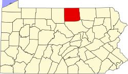
Charleston Township is a township in Tioga County, Pennsylvania, United States. The population was 3,562 at the 2020 census. Hills Creek State Park, one of 120 Pennsylvania state parks, is in Charleston Township.

<span class="mw-page-title-main">Covington Township, Tioga County, Pennsylvania</span> Township in Pennsylvania, United States

Covington Township is a township in Tioga County, Pennsylvania, United States. The population was 1,031 at the 2020 census.

<span class="mw-page-title-main">Gaines Township, Tioga County, Pennsylvania</span> Township in Pennsylvania, United States

Gaines Township is a township in Tioga County, Pennsylvania, United States. The population was 609 at the 2020 census.

<span class="mw-page-title-main">Hamilton Township, Tioga County, Pennsylvania</span> Township in Pennsylvania, United States

Hamilton Township is a township in Tioga County, Pennsylvania, United States. The population was 534 at the 2020 census.

<span class="mw-page-title-main">Richmond Township, Tioga County, Pennsylvania</span> Township in Pennsylvania, United States

Richmond Township is a township in Tioga County, Pennsylvania, United States. The population was 2,164 at the 2020 census.

<span class="mw-page-title-main">Sullivan Township, Pennsylvania</span> Township in Pennsylvania, United States

Sullivan Township is a township in Tioga County, Pennsylvania, United States. The population was 1,470 at the 2020 census.

<span class="mw-page-title-main">Ward Township, Pennsylvania</span> Township in Pennsylvania, United States

Ward Township is a township in Tioga County, Pennsylvania, United States. The population was 223 at the 2020 census. It is the only township in Tioga County that is not in Pennsylvania's 5th congressional district, instead being located in the 10th.

<span class="mw-page-title-main">Weston, Dunn County, Wisconsin</span> Town in Wisconsin, United States

Weston is a town in Dunn County, Wisconsin, United States. The population was 630 at the 2000 census. The unincorporated communities of Comfort and Weston are located in the town. The unincorporated community of Hatchville is also located partially in the town.

References

  1. "2016 U.S. Gazetteer Files". United States Census Bureau. Retrieved August 14, 2017.
  2. 1 2 3 4 Bureau, US Census. "City and Town Population Totals: 2020-2021". Census.gov. US Census Bureau. Retrieved July 16, 2022.
  3. "Census of Population and Housing". Census.gov. Retrieved June 4, 2016.
  4. "U.S. Census website". United States Census Bureau . Retrieved January 31, 2008.

41°47′48″N77°04′18″W / 41.79667°N 77.07167°W / 41.79667; -77.07167