Lega people

Last updated
Lega people
Siedlungsgebiet der Lega.png
Location of the Lega people in the Democratic Republic of the Congo
Total population
250,000
Regions with significant populations
Languages
Lega language

The Lega people (or Warega) are a Bantu ethnic group of the Democratic Republic of the Congo. In 1998 their population was about 250,000. [1]

Contents

Location

By the 1970s Lega people were mostly living in the middle and upper Elila valley and the upper Ulindi River valley. [2] These rivers both rise in the east of South Kivu and flow in a northwesterly direction through Maniema, joining the Lualaba downstream from Kindu. [3] The upper Ulindi valley has a richly diverse fauna, including many monkey species, chimpanzees, leopards, buffaloes, elephants and antelopes. [4] The valley is administratively divided into the Mwenga and Shabunda territories of South Kivu Province and the Pangi Territory of Maniema Province. [2]

The territory is covered by deep rain forest; in the east, rugged mountains rise to 6,000 feet (1,800 m) or more. The climate is hot and humid year round. Average temperature is 75 °F (24 °C) to 80 °F (27 °C). Annual rainfall is 60 inches (1,500 mm) to 80 inches (2,000 mm). The mountains hold areas of moist woodlands as well as montane forest and grasslands. To the north and west ,the forest is denser and deeper. The south of the region is covered with a patchwork of forest savannah and woodland. The entire forest has long been inhabited by humans, who cleared land for cultivation, and then let it return to the wild. In some places, the forest has not grown back but has been replaced by grassland. The forest has abundant wildlife, plus many plants and trees that provide food and are used for other purposes. [5]

Social structure

This necklace may have been part of the jewelry belonging to the Bwami religious and social organization. It is made of elephant ivory WLA ima Lega People ivory necklace.jpg
This necklace may have been part of the jewelry belonging to the Bwami religious and social organization. It is made of elephant ivory

The Lega people traditionally live in small village groups, with no central authority. [6] Within a community, a chief inherits his position on a patrilineal basis, and his close relatives have highest rank. [1] Counterbalancing this hereditary structure, the Bwami society also regulates social and political life. This society has seven levels for men and four for women and is open to all. An initiate advances through the ranks through a complex system of instruction, payment and initiation, achieving increasing status. A member of the highest level is recognized as a Kindi, a social leader with great moral authority. [6]

The Lega people are polytheistic. Their gods include Kalaga, the promiser; Kenkunga, the reassembler; Ombe, the hidden; Kaginga, the incarnation of evil. Kaginga assists sorcerers, but Bwami membership can protect an individual against the evil doings of witches. [1]

History

The Lega people originated in what is today Uganda and started to migrate from there to their present location in the 16th century. They were fierce warriors, conquering the people whose territory they entered and imposing many of their customs. [1] By the mid-1800s the Lega were surrounded by Arab / Swahili slave posts. Although none of these posts was within the Lega territory, they were constantly threatened by slave raids. For most of the period of the Congo Free State (1885–1908), the Lega territory was within the area that Tippu Tip and his successors had reserved. For a period two Arab agents of the Free State, Munie Chabodu and Munie Mtoro ruled the Lega and collected tribute in the form of rubber and ivory. They established towns at Micici on the Elila, Shabunda on the Ulindi, and Mulungu in the mountains. [7]

During the 1890s, the Free State fought a series of campaigns in which they drove away from the Arab slavers, and established government posts near Micici and Shabunda. The territory was not fully occupied until the 1900s. Under the Belgian Congo (1908–1960) the Lega were organized into chiefdoms, sectors, and territories, changes that were neither resisted nor welcomed by the Lega. Catholic missionaries arrived in the 1910s and the first Protestant mission was founded in 1922 in Shabunda. [8] Mining began in eastern Legaland in 1923, with further mines opened in the 1930s, employing many young Lega. Often they took a job only for a short period to earn enough money for some purpose such as Bwami initiation or marriage. [9]

In 1933 the Belgian authorities banned Bwami, and they prohibited the society again in 1948. [10] TBwami continued underground and was officially recognized again in 1958, but by then much of the tradition of art production had been lost. The Congo became independent in 1960. The regime of Mobutu Sese Seko (1965-1997) was harsh and corrupt, and Mobutu was eventually ousted in the First Congo War (1996-1997). This was soon followed by the Second Congo War (1998-2003) in which rebels attempted to throw out his successor, Laurent-Désiré Kabila. The Lega territory was the scene of many violent conflicts during this period.

Economy

Crowd at Shabundu, May 2007, after the visit of the Japanese ambassador Shabundu crowd May 2007.jpg
Crowd at Shabundu, May 2007, after the visit of the Japanese ambassador

The Lega traditionally lived by hunting and gathering, exploiting the rich resources of the forest. [9] When possible, they roast their food. The women are in charge of cooking. If it is not raining, they will cook outside on a hearth formed from slow-burning logs that support a pot over the fire. In poor weather they cook in kitchens within the long houses. The men eat as a group in the men's house, and the women eat with the young children in or outside the kitchen. [11]

The Lega villagers were forced by the colonial administration to produce manioc, bananas, and rice to feed the miners, causing considerable disruption to their lifestyle. [9] In more recent years, the Lega have taken to panning for gold in the rivers and working in the iron ore mines of the region. [1]

Art

Bwami masks and figures are symbols of the owner's rank within the Bwami society. [6] The objects represent moral or social values, and are used during initiation rites. [12] The Bwami works of art are often associated with proverbs, and these proverbs in conjunction with dance, poetry and song give wisdom to members of the society. Beauty, knowledge and power are intertwined. [10]

Some artwork can only be seen, handled or owned by the highest grades of the society. The objects are typically small and simple in form, and have a striking patina that derives from being handled or worn on the body. Ivory objects usually have russet or yellow patinas. [12] The masks are fairly standardized, although the most important masks with special ritual use or symbolic meaning may have distinctive design. A typical mask will have a concave heart-shaped face. The forehead protrudes slightly, the nose is narrow, eyes are slits and the mouth is slightly open. Every time a mask is used it is rubbed with white clay, over time acquiring a white patina. [6]

The Lega carve anthropomorphic figures out of wood and ivory.  Some of these figures are full-figure representations, while others are just heads or busts.  These distinctions of form are not meaningful to the Lega.  The Lega categorize and ascribe significance to each carved figure in a way that cannot be discerned by an outsider.  If an anthropomorphic figure is removed from the Lega community without properly inquiring about and recording the name and meaning of the work, there is no way to know later how the Lega might have categorized the figure. [13] :116

Related Research Articles

<span class="mw-page-title-main">South Kivu</span> Province of the Democratic Republic of the Congo

South Kivu is one of 26 provinces of the Democratic Republic of the Congo (DRC). Its capital is Bukavu.

<span class="mw-page-title-main">Ulindi River</span> River in Democratic Republic of the Congo

The Ulindi River is a tributary of the Lualaba River in the Democratic Republic of the Congo (DRC). There is a proposal to build a hydroelectric power plant on the river to power a gold mining project.

<span class="mw-page-title-main">Culture of the Democratic Republic of the Congo</span>

The culture of the Democratic Republic of the Congo is extremely varied, reflecting the great diversity and different customs which exist in the country. Congolese culture combines the influence of tradition to the region, but also combines influences from abroad which arrived during the era of colonization and continue to have a strong influence, without destroying the individuality of many tribal customs.

<span class="mw-page-title-main">Masisi Territory</span> Territory in North Kivu, DR Congo

Masisi Territory is a territory which is located within the North Kivu Province of the Democratic Republic of the Congo. Its political headquarters are located in the town of Masisi.

<span class="mw-page-title-main">Walikale Territory</span> Territory of the Democratic Republic of the Congo

Walikale Territory is a territory located within the Congolese province of North Kivu, in the eastern regions of the Democratic Republic of the Congo. The headquarters are in the town of Walikale. The locality is situated between Bukavu and Lubutu on DR Congo National Road No. 3 in the valley of the river Lowa, 135 km to the west of Goma.

<span class="mw-page-title-main">Shabunda Territory</span> Place in South Kivu, DR Congo

Shabunda is a town and a territory of South Kivu in the Democratic Republic of the Congo. Shabunda is the largest territory in the province, covering more than 25,000 square kilometres.

<span class="mw-page-title-main">Walungu Territory</span> Territory in South Kivu, DR Congo

WalunguTerritory is a territory located within the South Kivu Province in the eastern part of the Democratic Republic of the Congo (DRC). Situated approximately 40 km from Bukavu, the capital of South Kivu Province, it shares borders with Kabare Territory to the north, Mwenga Territory to the south, Uvira Territory and the Ruzizi River, as well as the Republics of Rwanda and Burundi to the east, and Shabunda Territory and part of Kabare Territory to the west. According to the 2018 national census, the region has a population of 716,671, with 672,436 residing in the Ngweshe Chiefdom and 44,235 in the Kaziba Chiefdom. Spanning an area of 1,800 km2, Walungu Territory has a population density of 398 inhabitants per square kilometer.

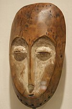
Daniel P. Biebuyck was a Belgian scholar of Central African art.

<span class="mw-page-title-main">Districts of the Democratic Republic of the Congo</span>

The provinces of the Democratic Republic of the Congo were divided into 26 districts. Those in turn were divided into territories or communes.

The Elila River is a tributary of the Lualaba River in the Democratic Republic of the Congo. It rises in Mwenga Territory of Sud-Kivu Province and flows west through Shabunda Territory and then Pangi Territory in Maniema Province, entering the Lualaba just downstream of Kindu.

Pangi Territory is an administrative area in Maniema Province of the Democratic Republic of the Congo. The headquarters is the town of Pangi.

Kalehe Territory is a territory in South Kivu, Democratic Republic of the Congo. Its administrative centre is the town of Kalehe on the western shore of Lake Kivu. Other important towns include Buguli, Bunyakiri, Kalangala, Kalungu, Minova, and Nyamasasa.

<span class="mw-page-title-main">Districts of the Belgian Congo</span>

The Districts of the Belgian Congo were the primary administrative divisions when Belgium annexed the Congo Free State in 1908, each administered by a district commissioner. In 1914 they were distributed among four large provinces, with some boundary changes. In 1933 the provinces were restructured into six, again with boundary changes. The number of districts fluctuated between 12 and 26 through splits and consolidations, first rising, then falling, then rising again.

Kayuyu is a settlement in Maniema province, Democratic Republic of the Congo.

<span class="mw-page-title-main">Kasika (village)</span> Village in Democratic Republic of the Congo

Kasika is a village located in the Luindi Chiefdom within the Mwenga Territory of the South Kivu Province, situated in the eastern region of the Democratic Republic of the Congo (DRC). Geographically positioned at 965 meters above sea level, Kasika strategically lies near Kihovu and Kahulile, approximately 108 kilometers from Bukavu, near the Rwandan border. The region is more than clusters of mud huts built around a Catholic parish on a hill overlooking a valley. It was the headquarters of the customary chief of the Nyindu ethnic community, whose house and office sat on a hill opposite the parish, a series of large, red-brick structures with cracked ceramic shingles as roofing, laced with vines.

Kaniola Groupement, also known as Kanyola, is one of the 16 groupements (groupings) that constitute the Ngweshe Chiefdom of the Shi people. Kaniola Groupement is located at an elevation of 1800 meters and is situated 64 km from Bukavu city. It shares borders with the Kahuzi-Biéga National Park and the Nindja Chiefdom to the northeast, while being bordered by the Izege groupement and Walungu groupement to the east. It is also bordered by the Burhale groupement and Mulamba groupement in the west.

<span class="mw-page-title-main">Mutambala</span> Sector in the DRC

Mutambala is a sector that constitutes one of the four sectors in the Fizi Territory of the South Kivu Province in the eastern part of the Democratic Republic of the Congo. Mutambala is situated near Lake Tanganyika, in the west by the Lulenge sector, in the north by the Tangani'a sector, and in the south by the Ngandja sector. It has a surface area of 777 km 2. The sector consists of five groupings (groupements), including the Basimukindja groupings, the Batombwe groupings, and the Babwari groupings.

<span class="mw-page-title-main">Nyindu people</span> Congolese ethnic group

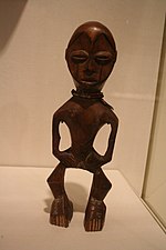
The Nyindu people, are an ethnic group predominantly found along the Ulindi River in the north, west, and south, as well as the Kilungutwe River, located in the Mwenga Territory in the southern part of South Kivu Province in the eastern region of the Democratic Republic of the Congo (DRC). The Nyindu people belong to the Bantu ethnic group and linguistic family, which is among the most populous and diverse ethnic groups in the South Kivu Province. They are known for their traditional agricultural practices, which include cultivating crops such as maize, cassava, and beans. They also engage in animal husbandry, particularly with cattle. The Nyindu are organized into clans, and each clan has a chief who serves as a leader and arbitrator.

The Kilungutwe River is a watercourse located in the Mwenga Territory of the South Kivu Province, situated in the eastern part of the Democratic Republic of the Congo (DRC). With an elevation of 882 meters, it functions as a tributary to the Ulindi River. Following the confluence with the Ulindi River approximately 30 km northwest, the Ulindi River proceeds on its course, eventually joining the Congo River. The Kilungutwe River was historically known as the gateway to the jungle from the highlands to the northeast.

The Luindi Chiefdom, also known as Lwindi Chiefdom, is a chiefdom located in the Mwenga Territory of the South Kivu Province in the eastern region of the Democratic Republic of the Congo (DRC). It is situated in the mountainous area of the Itombwe Massif, which is known for its rich biodiversity and unique wildlife.

References

  1. 1 2 3 4 5 Lega Information.
  2. 1 2 Biebuyck 1973, p. 3.
  3. Blaes 2008.
  4. Biebuyck 1973, p. 5.
  5. Biebuyck 1973, p. 15.
  6. 1 2 3 4 Lega Bwami masks.
  7. Biebuyck 1973, pp. 12–13.
  8. Biebuyck 1973, p. 13.
  9. 1 2 3 Biebuyck 1973, p. 14.
  10. 1 2 Major Exhibition.
  11. Elisofon 1967.
  12. 1 2 Grootaers 2003.
  13. Cameron, Elisabeth Lynn (2001). Art of the Lega. Los Angeles. Fowler Museum of Cultural History University of California. Los Angeles: UCLA Fowler Museum of Cultural History. ISBN   0-930741-87-0. OCLC   47718038.

Sources

Commons-logo.svg Media related to Lega people at Wikimedia Commons