List of airports in the Lower Mainland

Last updated

Canada British Columbia relief location map.jpg
Red pog.svg
Lower Mainland
Location in British Columbia
15 Metro Vancouver Regional District British Columbia.svg
Red pog.svg
CYVR
Red pog.svg
CZBB
Red pog.svg
CAK3
Red pog.svg
CBQ2
Red pog.svg
CYNJ
Red pog.svg
CYPK
Red pog.svg
CSK8
Red pog.svg
CAJ8
Red pog.svg
CYHC
Red pog.svg
CAM9
Red pog.svg
CAS4
Red pog.svg
CBC7
Red pog.svg
CTK8
Red pog.svg
CNW9
Red pog.svg
CAK7
Red pog.svg
CFR6
Red pog.svg
CBD2
Red pog.svg
CSE7
Red pog.svg
CBK4
Red pog.svg
CVS3
Locations in Vancouver

The following active airports serve the Lower Mainland region of British Columbia, Canada, including Greater Vancouver and the Fraser Valley: [1] [2]

Contents

Land airports

Scheduled commercial airline service

Vancouver International Airport Vancouver International (3572469058).jpg
Vancouver International Airport
Abbotsford International Airport YXX rwy 0725.jpg
Abbotsford International Airport
Vancouver Harbour Flight Centre Vancouver Harbour Water Airport (CXH - CYHC) overview.jpg
Vancouver Harbour Flight Centre
Control tower at Boundary Bay Airport CZBB Control Tower.JPG
Control tower at Boundary Bay Airport
Airport name ICAO/TC LID/IATA LocationCoordinates
Abbotsford International Airport CYXX/YXX Abbotsford 49°01′31″N122°21′36″W / 49.02528°N 122.36000°W / 49.02528; -122.36000 (Abbotsford International Airport)
Vancouver International Airport CYVR/YVR Richmond 49°11′41″N123°11′02″W / 49.19472°N 123.18389°W / 49.19472; -123.18389 (Vancouver International Airport)

Other

Airport name ICAO/TC LID/IATA LocationCoordinates
Boundary Bay Airport CZBB/YDT Delta 49°04′26″N123°00′27″W / 49.07389°N 123.00750°W / 49.07389; -123.00750 (Boundary Bay Airport)
Chilliwack Airport CYCW/YCW Chilliwack 49°09′10″N121°56′20″W / 49.15278°N 121.93889°W / 49.15278; -121.93889 (Chilliwack Airport)
Delta/Delta Heritage Air Park CAK3 Delta 49°04′25″N122°56′28″W / 49.07361°N 122.94111°W / 49.07361; -122.94111 (Delta/Delta Heritage Air Park)
Fort Langley Airport CBQ2 Fort Langley 49°10′03″N122°33′16″W / 49.16750°N 122.55444°W / 49.16750; -122.55444 (Fort Langley Airport)
Hope Aerodrome CYHE/YHE Hope 49°22′06″N121°29′53″W / 49.36833°N 121.49806°W / 49.36833; -121.49806 (Hope Airport)
Langley Regional Airport CYNJ/YLY Langley 49°06′04″N122°37′50″W / 49.10111°N 122.63056°W / 49.10111; -122.63056 (Langley Regional Airport)
Pitt Meadows Airport CYPK Pitt Meadows 49°12′58″N122°42′36″W / 49.21611°N 122.71000°W / 49.21611; -122.71000 (Pitt Meadows Regional Airport)
Squamish Airport CYSE/YSE Squamish 49°46′54″N123°09′43″W / 49.78167°N 123.16194°W / 49.78167; -123.16194 (Squamish Airport)
Surrey/King George Airpark CSK8 Surrey 49°05′42″N122°49′10″W / 49.09500°N 122.81944°W / 49.09500; -122.81944 (Surrey/King George Airpark)

Former

Airport name ICAO/TC LID/IATA LocationCoordinates
CFB Chilliwack Chilliwack 49°06′11″N121°57′46″W / 49.10306°N 121.96278°W / 49.10306; -121.96278 (CFB Chilliwack (abondened))
Canadian Forces Station Ladner Delta 49°04′26″N123°00′27″W / 49.07389°N 123.00750°W / 49.07389; -123.00750 (Canadian Forces Station Ladner (abandoned))
Minoru Park Richmond 49°09′56″N123°08′43″W / 49.16556°N 123.14528°W / 49.16556; -123.14528 (Minoru Park (abandoned))
Tipella Airport CBB7 Tipella 49°44′35″N122°09′47″W / 49.74306°N 122.16306°W / 49.74306; -122.16306 (Tipella Airport (abandoned))

Water aerodromes

Scheduled commercial airline service

Airport name ICAO/TC LID/IATA LocationCoordinates
Pitt Meadows Water Aerodrome CAJ8 Pitt Meadows 49°12′32.68″N122°42′31.10″W / 49.2090778°N 122.7086389°W / 49.2090778; -122.7086389 (Pitt Meadows Water Aerodrome)
Vancouver Harbour Flight Centre CYHC/CXH Coal Harbour 49°17′40″N123°06′41″W / 49.29444°N 123.11139°W / 49.29444; -123.11139 (Vancouver Harbour Water Airport)
Vancouver International Water Airport CAM9 Richmond 49°11′00″N123°10′00″W / 49.18333°N 123.16667°W / 49.18333; -123.16667 (Vancouver International Water Airport)

Other

Airport name ICAO/TC LID/IATA LocationCoordinates
Fort Langley Water Aerodrome CAS4 Fort Langley 49°10′00″N122°32′00″W / 49.16667°N 122.53333°W / 49.16667; -122.53333 (Fort Langley Water Aerodrome)
Harrison Hot Springs Water Aerodrome CAE7 Harrison Hot Springs 49°18′00″N121°46′00″W / 49.30000°N 121.76667°W / 49.30000; -121.76667 (Harrison Hot Springs Water Aerodrome)

Former

Airport name ICAO/TC LID/IATA LocationCoordinates
Mission Water Aerodrome CAY7 Mission 49°08′00″N122°18′00″W / 49.13333°N 122.30000°W / 49.13333; -122.30000 (Mission Water Aerodrome (abandoned))

Heliports

Scheduled commercial airline service

Airport name ICAO/TC LID/IATA LocationCoordinates
Vancouver/Harbour (Public) Heliport CBC7 Downtown Vancouver 49°17′13″N123°06′22″W / 49.28694°N 123.10611°W / 49.28694; -123.10611 (Vancouver/Harbour (Public) Heliport)

Other

Airport name ICAO/TC LID/IATA LocationCoordinates
Abbotsford (Regional Hospital & Cancer Centre) Heliport CAB5 Abbotsford 49°02′10″N122°18′51″W / 49.03611°N 122.31417°W / 49.03611; -122.31417 (Abbotsford (Regional Hospital & Cancer Centre) Heliport)
Abbotsford (Sumas Mountain) Heliport CSM7 Abbotsford 49°06′18″N122°11′51″W / 49.10500°N 122.19750°W / 49.10500; -122.19750 (Abbotsford (Sumas Mountain) Heliport)
Abbotsford (Teck) Heliport CTK8 Abbotsford 49°07′37″N122°23′41″W / 49.12694°N 122.39472°W / 49.12694; -122.39472 (Abbotsford (Teck) Heliport)
New Westminster (Royal Columbian Hospital) Heliport CNW9 New Westminster 49°13′36″N122°53′32″W / 49.22667°N 122.89222°W / 49.22667; -122.89222 (New Westminster (Royal Columbian Hospital) Heliport)
Vancouver (Children & Women's Health Centre) HeliportCAK7 Vancouver 49°14′38″N123°07′39″W / 49.24389°N 123.12750°W / 49.24389; -123.12750 (Vancouver Children & Women's Health Centre Heliport)
Vancouver/Coquitlam Fire and Rescue Heliport CFR6 Vancouver 49°17′30″N122°47′32″W / 49.29167°N 122.79222°W / 49.29167; -122.79222 (Vancouver/Coquitlam Fire and Rescue Heliport)
Vancouver/Delta (North) Heliport CBD2 Delta 49°07′12″N123°02′45″W / 49.12000°N 123.04583°W / 49.12000; -123.04583 (Vancouver/Delta (North) Heliport)
Vancouver/Delta (SEI) Heliport CSE7 Delta 49°07′45″N123°01′06″W / 49.12917°N 123.01833°W / 49.12917; -123.01833 (Vancouver/Delta (SEI) Heliport)
Vancouver (General Hospital) Heliport CBK4 Vancouver 49°15′42″N123°07′20″W / 49.26167°N 123.12222°W / 49.26167; -123.12222 (Vancouver (General Hospital) Heliport)
Vancouver (Surrey Memorial Hospital) Heliport CVS3 Surrey 49°10′33″N122°50′38″W / 49.17583°N 122.84389°W / 49.17583; -122.84389 (Vancouver (Surrey Memorial Hospital) Heliport)

See also

Map all coordinates using: OpenStreetMap

Related Research Articles

Canada's National Airport System (NAS) was defined in the National Airports Policy published in 1994. It was intended to include all airports with an annual traffic of 200,000 passengers or more, as well as airports serving the national, provincial and territorial capitals.

<span class="mw-page-title-main">Campbell River Airport</span> Airport in Campbell River, British Columbia

Campbell River Airport is located 4.5 nautical miles south of the city of Campbell River, British Columbia, Canada.

<span class="mw-page-title-main">Pitt Meadows Regional Airport</span> Airport in Pitt Meadows, British Columbia

Pitt Meadows Regional Airport is a Canadian general aviation airport located in the southwest corner of Pitt Meadows, British Columbia. In 2022, the airport had 127,284 aircraft movements, making it the 3rd busiest airport in British Columbia and the 9th busiest airport in Canada.

Courtenay Airport is located 2.5 nautical miles west of Courtenay, British Columbia, Canada.

Delta/Delta Heritage Air Park is located 4.5 nautical miles east of Delta, British Columbia, Canada.

Hope Aerodrome is located 2.6 nautical miles west of Hope Townsite within the municipal District of Hope, British Columbia, Canada.

Surrey/King George Airpark was located 1.7 nautical miles southwest of Surrey, British Columbia, Canada.

<span class="mw-page-title-main">Vancouver Harbour Flight Centre</span> Airport in Coal Harbour, Burrard Inlet

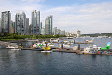
Vancouver Harbour Flight Centre, Vancouver Harbour Water Aerodrome or Vancouver Coal Harbour Seaplane Base, is a registered aerodrome located at Coal Harbour in Vancouver, British Columbia, Canada. The flight centre is within walking distance of the HeliJet heliport and Waterfront Station, a public transit hub in Downtown Vancouver.

Vancouver International Water Airport is located adjacent to Vancouver International Airport in Richmond, British Columbia, Canada.

Quamichan Lake Water Aerodrome is located on Quamichan Lake, 2.9 nautical miles north northeast of Duncan, British Columbia, Canada.

References

  1. Canada Flight Supplement. Effective 0901 Z 16 July 2020 to 0901Z 10 September 2020.
  2. Nav Canada 's Water Aerodrome Supplement. Effective 0901 Z 26 March 2020 to 0901Z 22 April 2021.