List of bridges in Ukraine

Last updated

This is a list of bridges and viaducts in Ukraine, including those for pedestrians and vehicular traffic.

Contents

Historical and architectural interest bridges

NameUkrainianDistinctionLengthTypeCarries
Crosses
OpenedLocationOblastRef.
KamPod Nowoplaniwsky mist IMG 1803 68-104-0160.JPG 1 Novoplanovsky Bridge  [ uk ]Новопланівський містMonument No. 68-104-0160149 m (489 ft) Beam bridge
Steel
Road bridge
Smotrych
1872 Kamianets-Podilskyi
48°40′39.7″N26°34′38.8″E / 48.677694°N 26.577444°E / 48.677694; 26.577444 (Novoplanovsky Bridge)
Khmelnytskyi [S 1]
[1]
Zaliznichni kam'iani mosti (Vorokhta) 5.jpg 2 Vorokhta Viaduct  [ uk ]
closed
Віадук у ВорохтіMonument No. 26-110-0004130 m (430 ft) Masonry
12 arches
Railway bridge
Prut
1895 Vorokhta
48°16′52.9″N24°33′52.3″E / 48.281361°N 24.564528°E / 48.281361; 24.564528 (Vorokhta Viaduct)
Ivano-Frankivsk Oblast [S 2]
Iron bridge of Galych.jpg 3 Old iron bridge (Halych) Старий міст через ДністерMonument No. 26-212-0016312 m (1,024 ft) Truss bridge
Steel
Road bridge
Dniester
1912 Halych
49°07′37.9″N24°43′45.0″E / 49.127194°N 24.729167°E / 49.127194; 24.729167 (Old iron bridge (Halych))
Ivano-Frankivsk Oblast [2]

Major road and railway bridges

This table presents the structures with spans greater than 200 meters (non-exhaustive list).

NameUkrainianSpanLengthTypeCarries
Crosses
OpenedLocationOblastRef.
Podol'sko-Voskresenskii most, oktiabr' 2019.jpg 1 Podilskyi Bridge
under construction
Подільський міст344 m (1,129 ft)4,432 m (14,541 ft) Arch
2 levels steel tied-arch
6 lanes road bridge
Kyiv Metro Line 4.svg Podilsko-Vyhurivska line
Dnieper
Kyiv
50°28′22.6″N30°32′05.2″E / 50.472944°N 30.534778°E / 50.472944; 30.534778 (Podilskyi Bridge)
Kyiv [S 3]
Pivnichnyi Bridge in Kyiv.jpg 2 Pivnichnyi Bridge Північний міст300 m (980 ft)816 m (2,677 ft) Cable-stayed
Composite steel/concrete deck, concrete pylon
84+300+5x63
Moskovs'kiy Avenue
Dnieper
1976 Kyiv
50°29′27.6″N30°32′11.4″E / 50.491000°N 30.536500°E / 50.491000; 30.536500 (Pivnichnyi Bridge)
Kyiv [S 4]
Pivdennii mist u Kiievi, z Livogo berega.JPG 3 Pivdennyi Bridge Південний міст271 m (889 ft)1,256 m (4,121 ft) Cable-stayed
Composite steel/concrete deck, concrete pylon
90+271+63
1993 Kyiv
50°23′41.6″N30°35′29.1″E / 50.394889°N 30.591417°E / 50.394889; 30.591417 (Pivdennyi Bridge)
Kyiv [S 5]
Zaporizhia (20209985781)2.jpg 4 New Zaporizhzhia Dniper Bridge Новий міст через Дніпро та Старий Дніпро260 m (850 ft)660 m (2,170 ft) Cable-stayed
Steel box girder deck, concrete pylons
Twin bridges
6 lanes road bridge
Dnieper
2022 Zaporizhzhia
47°50′33.3″N35°05′08.1″E / 47.842583°N 35.085583°E / 47.842583; 35.085583 (New Zaporizhzhia Dniper Bridge)
Zaporizhzhia [Note 1]
[S 6]
Mosti Preobrazhens'kogo-2.jpg 5 Zaporizhzhia Bridge Міст у Запоріжжі234 m (768 ft)389 m (1,276 ft) Arch
2 levels concrete deck arch
Zaporizhzhia - Nikopol railway line
T0806
Dnieper
1952 Zaporizhzhia
47°49′14.0″N35°04′29.9″E / 47.820556°N 35.074972°E / 47.820556; 35.074972 (Zaporizhzhia Bridge)
Zaporizhzhia [S 7]
[3]
[4]
Krymskii most 13 sentiabria 2019 goda (1).jpg 6 Crimean Rail Bridge Міст через Керченську протоку227 m (745 ft)18,100 m (59,400 ft) Arch
Steel tied-arch
2019 Kerch - Taman
45°18′30.8″N36°30′20.6″E / 45.308556°N 36.505722°E / 45.308556; 36.505722 (Crimean Rail Bridge)
Autonomous Republic of Crimea
Flag of Russia.svg  Russia
[S 8]
Arki Krymskogo mosta 21 dekabria 2019 goda.jpg 7 Crimean Road Bridge Міст через Керченську протоку227 m (745 ft)16,900 m (55,400 ft) Arch
Steel tied-arch
2018 Kerch - Taman
45°18′31.6″N36°30′22.5″E / 45.308778°N 36.506250°E / 45.308778; 36.506250 (Crimean Road Bridge)
Autonomous Republic of Crimea
Flag of Russia.svg  Russia
[S 9]
Arkovii mist v Zaporizhzhi.JPG 8 Zaporizhzhia Arch Bridge Арковий міст у Запоріжжі196 m (643 ft)320 m (1,050 ft) Arch
Steel deck arch
Tahans'ka Street
Dnieper
1974 Zaporizhzhia
47°51′42.4″N35°03′43.5″E / 47.861778°N 35.062083°E / 47.861778; 35.062083 (Zaporizhzhia Arch Bridge)
Zaporizhzhia [S 10]
[5]
[4]
9 Running Dear Bridge Мост Бегущая Лань174 m (571 ft)379 m (1,243 ft) Box girder
Steel
V-shaped legs
1973 Kamianets-Podilskyi
48°39′34.9″N26°34′41.6″E / 48.659694°N 26.578222°E / 48.659694; 26.578222 (Running Dear Bridge)
Khmelnytskyi [S 11]
Ribal's'kii vantovii mist.jpg 10 Rybalskyi Cable-stayed Bridge  [ uk ]
closed
Рибальський вантовий міст144 m (472 ft)474 m (1,555 ft) Cable-stayed
Concrete deck and pylons
66+144+66
1964 Kyiv
50°28′24.8″N30°31′24.1″E / 50.473556°N 30.523361°E / 50.473556; 30.523361 (Rybalskyi Cable-stayed Bridge)
Kyiv [S 12]
Bridges in Zaporizhia 8861.jpg 11 Preobrazhenskyi Bridge  [ uk ]Мости Преображенського140 m (460 ft)(x3)560 m (1,840 ft) Arch
2 levels concrete deck arch
Zaporizhzhia - Nikopol railway line
T0806
Dnieper
1952 Zaporizhzhia
47°50′43.6″N35°05′01.5″E / 47.845444°N 35.083750°E / 47.845444; 35.083750 (Preobrazhenskyi Bridge)
Zaporizhzhia [S 13]
[4]
Nicholas Chain Bridge LOC 03819.jpg 12 Nicholas Chain Bridge
demolished in 1920
Миколаївський ланцюговий міст134 m (440 ft)(x4)781 m (2,562 ft) Suspension
Chain bridge, 5 masonry pylons
69+4x134+69
1855 Kyiv
50°26′32.3″N30°33′52.7″E / 50.442306°N 30.564639°E / 50.442306; 30.564639 (Nicholas Chain Bridge)
Kyiv [S 14]
Zaporizhia (19580830863).jpg 13 New Zaporizhzhia Dniper Bridge (west bridge) Новий міст через Дніпро та Старий Дніпро128 m (420 ft)340 m (1,120 ft) Box girder
Steel
106+128+106
6 lanes road bridge
Dnieper
2022 Zaporizhzhia
47°49′09.6″N35°04′36.9″E / 47.819333°N 35.076917°E / 47.819333; 35.076917 (New Zaporizhzhia Dniper Bridge (west bridge))
Zaporizhzhia [Note 1]
[S 15]
Nicholas Chain Bridge in Kiev 2010 01.JPG 14 Kyiv Metro Bridge Міст Метро117 m (384 ft)(x2)684 m (2,244 ft) Arch
Concrete deck arch
1965 Kyiv
50°26′33.6″N30°33′51.2″E / 50.442667°N 30.564222°E / 50.442667; 30.564222 (Kyiv Metro Bridge)
Kyiv [S 16]
View to the Gulf of Odessa.jpg 15 Odesa Seaport Overpass 115 m (377 ft)516 m (1,693 ft) Cable-stayed
Steel deck and pylon

1998 Odesa
46°29′29.2″N30°44′21.1″E / 46.491444°N 30.739194°E / 46.491444; 30.739194 (Odesa Seaport Overpass)
Odesa [S 17]
Petrovskii zheleznodorozhnyi most Kiev.jpg 16 Petrovski Bridge Петрівський міст110 m (360 ft)(x2)1,430 m (4,690 ft) Truss bridge
Steel
1917 Kyiv
50°29′01.5″N30°32′31.7″E / 50.483750°N 30.542139°E / 50.483750; 30.542139 (Petrovski Bridge)
Kyiv [S 18]
Darnits'ki mosti, v t. ch. "mist Kirpi" - panoramio.jpg 17 Darnytskyi Railroad Bridge Дарницький міст110 m (360 ft)(x3)1,067 m (3,501 ft) Arch
Steel through arch
Railway bridge
Dnieper
1951 Kyiv
50°25′02.6″N30°35′25.5″E / 50.417389°N 30.590417°E / 50.417389; 30.590417 (Darnytskyi Railroad Bridge)
Kyiv [S 19]
2019-07-22 Darnytsia Bridge, Kyiv.jpg 18 New Darnytskyi Bridge Новий Дарницький міст110 m (360 ft)(x3)1,066 m (3,497 ft) Arch
Steel tied-arch
Railroad bridge
Dnieper
2011 Kyiv
50°25′01.1″N30°35′26.1″E / 50.416972°N 30.590583°E / 50.416972; 30.590583 (Petrovski Bridge)
Kyiv [S 20]
[6]
Merefo-Khersons'kii mist z visoti.jpg 19 Merefa-Kherson bridge Мерефо-Херсонський міст109 m (358 ft)(x2)1,627 m (5,338 ft) Arch
Concrete through arch
Merefa-Kherson railway line
Dnieper
1932
1951
Dnipro
48°28′02.6″N35°04′58.0″E / 48.467389°N 35.082778°E / 48.467389; 35.082778 (Merefa-Kherson bridge)
Dnipropetrovsk [S 21]
Kaydacky-bridge Dnipropetrovsk from GOROD.DP.UA.jpg 20 Kaidatsky Bridge Кайдацький міст105 m (344 ft)(x2)1,732 m (5,682 ft) Box girder
Prestressed concrete
73+2x10⁵+73
1982 Dnipro
48°29′46.9″N34°57′52.3″E / 48.496361°N 34.964528°E / 48.496361; 34.964528 (Kaidatsky Bridge)
Dnipropetrovsk [S 22]
[7]
View of Kherson and Antonovskiy bridge, 2006.jpg 21 Antonivka Road Bridge Антонівський міст105 m (344 ft)(x2)1,366 m (4,482 ft) Box girder
Prestressed concrete
70+2x10⁵+70
1985 Kherson
46°40′11.3″N32°43′12.9″E / 46.669806°N 32.720250°E / 46.669806; 32.720250 (Antonivka Road Bridge)
Kherson [S 23]
[7]
Rusanovskii most Kiev iz knigi 1913 goda.jpg 22 Rusanivsky Bridge (1906)  [ uk ]
demolished in 1943
Русанівський міст (1906)101 m (331 ft)203 m (666 ft) Arch
Steel tied-arch
1906 Kyiv
50°26′51.7″N30°35′04.9″E / 50.447694°N 30.584694°E / 50.447694; 30.584694 (Rusanivsky Bridge (1906))
Kyiv
Most Evhenii Bosh Kiev 1930s.jpg 23 Yevgenii Bosch Bridge  [ uk ]
demolished in 1941
Міст імені Євгенії Бош Suspension 1925 Kyiv
50°26′32.0″N30°33′52.3″E / 50.442222°N 30.564528°E / 50.442222; 30.564528 (Yevgenii Bosch Bridge)
Kyiv

See also

Map all coordinates using: OpenStreetMap

Notes and references

  1. 1 2 The length given only takes into account the main bridge, central span(s) and shore span(s), approach viaducts are not counted.
  1. "Новопланівський міст, Кам'янець-Подільський" [Novoplanivsky bridge, Kamianets-Podilskyi]. ua.igotoworld.com (in Ukrainian).
  2. "ДОПОМОЖІТЬ ВРЯТУВАТИ СТАРИЙ ГАЛИЦЬКИЙ МІСТ!" [Help save the old Halitic Bridge!] (in Ukrainian). Archived from the original on 3 March 2016.
  3. Wai-Fah Chen, Lian Duan Arch bridges, p.882
  4. 1 2 3 "МОСТЫ ЗАПОРОЖЬЯ" [Zaporizhzhia Bridges] (in Russian). Archived from the original on 8 December 2015.
  5. Wai-Fah Chen, Lian Duan Arch bridges, p.886
  6. "Аварій і особливо небезпечний, або Дарницький міст: Режим очікування" [Accident and particularly dangerous, or Darnytskyi bridge: Standby mode]. ibud.ua (in Ukrainian).
  7. 1 2 Wai-Fah Chen, Lian Duan Concrete girder bridges, p.871

Further reading

Related Research Articles

<span class="mw-page-title-main">Orthotropic deck</span> Welded steel segmented construction technique for bridge decks

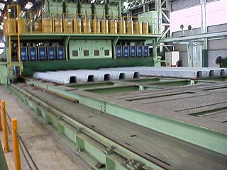
An orthotropic bridge or orthotropic deck is typically one whose fabricated deck consists of a structural steel deck plate stiffened either longitudinally with ribs or transversely, or in both directions. This allows the fabricated deck both to directly bear vehicular loads and to contribute to the bridge structure's overall load-bearing behaviour. The orthotropic deck may be integral with or supported on a grid of deck framing members, such as transverse floor beams and longitudinal girders. All these various choices for the stiffening elements, e.g., ribs, floor beams and main girders, can be interchanged, resulting in a great variety of orthotropic panels.

<span class="mw-page-title-main">Bridges in Kyiv</span>

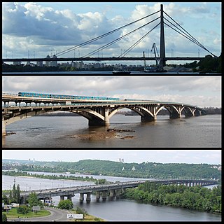
Kyiv, historically situated on the right bank of the Dnieper River, now covers both banks of the river whose width, as it flows through the city, reaches several hundred metres. Additionally, several tributaries join the Dnieper inside or just north or south of the historic city. Currently there are eight bridges spanning across the river and a few dozen bridges across the canals and Dnieper tributaries.

<span class="mw-page-title-main">Jiujiang Yangtze River Bridge</span> Bridge in Jiangxi / Huangmei County, Hubei

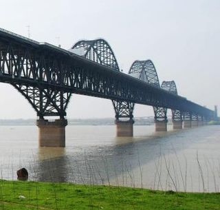
The Jiujiang Yangtze River Bridge is a combined road-rail bridge over the Yangtze River near the city of Jiujiang, Jiangxi Province in eastern China. It links Xunyang District of Jiujiang, south of the river, with Xiaochi Town in Huangmei County, Hubei Province, to the north. The central section of the bridge uses a combined arch and truss structure and the bridge is one of the longest continuous truss bridges in the world, with a longest span of 216 meters (709 ft) and a total truss length of 1,314 meters (4,311 ft) =3x162+180+216+180+2x126. The double deck bridge carries four vehicular lanes and two sidewalks on the top deck and two railway tracks on the bottom deck.

<span class="mw-page-title-main">Podilskyi Bridge</span> Bridge in Kyiv, Ukraine

The Podilskyi Bridge, also known as Podilsko-Voskresenskyi Bridge, is a combined road-rail bridge over the Dnipro River under construction in Kyiv, Ukraine. It is a focal point of construction of the Podilsko-Vyhurivska Line of the Kyiv Metro. A part of the bridge was opened with restrictions on 1 December 2023.

<span class="mw-page-title-main">Maguo River Bridge</span> Bridge in Kunming, Yunnan

The Maguo River Bridge is a beam bridge in Fumin County, Kunming, Yunnan, China. The bridge is part of the Jiaozishan highway. It has a main span of 190 metres (620 ft) and sits 180 metres (590 ft) above the Maguo River below.

<span class="mw-page-title-main">Merefa-Kherson bridge</span> Bridge

The Merefa-Kherson bridge is a 1,600 m (5,249.3 ft) single track railway bridge crossing the Dnieper in Dnipro and part of the railway line between cities of Merefa and Kherson.

<span class="mw-page-title-main">Zaporizhzhia Arch Bridge</span> Bridge in Zaporizhzhia, Ukraine

Zaporizhzhia Arch Bridge is the longest arch bridge in Ukraine. The bridge connects the west bank area of Zaporizhzhia with the north side of Khortytsia Island by spanning the smaller eastern branch of the River Dnieper.

<span class="mw-page-title-main">New Zaporizhzhia Dniper Bridge</span> Bridge in Zaporizhzhia, Ukraine

The New Zaporizhzhia Dniper Bridge is an under-construction controlled-access highway bridge in Zaporizhzhia, Ukraine. Construction of the bridge began in August 2004 with the first span of the bridge opened for public vehicular use in January 2022 after several years of delays. The bridge was opened in a public ceremony on January 22, 2022, by President Volodymyr Zelensky. When completed, the bridge will stand at a height of 151 meters, making it the tallest in Ukraine and the eighth tallest in Europe.