The history of Grenada in the Caribbean, part of the Lesser Antilles group of islands, covers a period from the earliest human settlements to the establishment of the contemporary nationstate of Grenada.

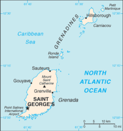
Grenada is an island country located between the Caribbean Sea and Atlantic Ocean, north of Trinidad and Tobago. It is located at 12°07′N61°40′W. There are no large inland bodies of water on the island, which consists entirely of the state of Grenada. The coastline is 121 km long. The island has 15 constituencies and speaks English and Grenadian Creole. It is volcanic in origin and its topography is mountainous.

Saint Lucia is an island country of the West Indies in the eastern Caribbean. The island was previously called Iouanalao and later Hewanorra, names given by the native Arawaks and Caribs (respectively), two Amerindian peoples. Part of the Windward Islands of the Lesser Antilles, it is located north/northeast of the island of Saint Vincent, northwest of Barbados and south of Martinique. It covers a land area of 617 km2 with an estimated population of over 180,000 people as of 2022. The nation's capital and largest city is Castries.

Saint Lucia was inhabited by the Arawak and Kalinago Caribs before European contact in the early 16th century. It was colonized by the British and French in the 17th century and was the subject of several possession changes until 1814, when it was ceded to the British by France for the final time. In 1958, St. Lucia joined the short-lived semi-autonomous West Indies Federation. Saint Lucia was an associated state of the United Kingdom from 1967 to 1979 and then gained full independence on February 22, 1979.

St. George's is the capital of Grenada. The town is surrounded by a hillside of an old volcano crater and is located on a horseshoe-shaped harbour.
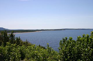
Bras d'Or Lake is an irregular estuary in the centre of Cape Breton Island in Nova Scotia, Canada. It has a connection to the open sea, and is tidal. It also has inflows of fresh water from rivers, making the brackish water a very productive natural habitat. It was designated the Bras d'Or Lake Biosphere Reserve by UNESCO in 2011.
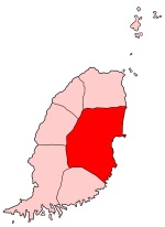
Saint Andrew's is the largest parish in Grenada. The main town is Grenville, which is also Grenada's second largest town after St George's. Grenville is also known as La Baye.
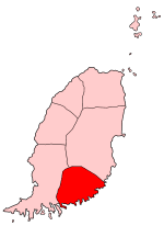
Saint David's Parish is the fourth largest of the parishes of Grenada in the island's southeast. The parish's main town is St. David's, located between La Tante and Westerhall. Because St David's is so small, the parish is sometimes referred to as "The Virgin Parish".
Upper La Tante is a town in Saint David Parish, Grenada. It is located towards the southern end of the island.

Grenada is an island country in the West Indies in the Caribbean Sea at the southern end of the Grenadines island chain. Grenada consists of the island of Grenada itself, two smaller islands, Carriacou and Petite Martinique, and several small islands which lie to the north of the main island and are a part of the Grenadines. It is located northwest of Trinidad and Tobago, northeast of Venezuela and southwest of Saint Vincent and the Grenadines. Its size is 348.5 square kilometres (134.6 sq mi), and it had an estimated population of 124,523 in July 2021. Its capital is St. George's. Grenada is also known as the "Island of Spice" due to its production of nutmeg and mace crops.

The following is an alphabetical list of topics related to the nation of Grenada.

Grand Etang Lake is a crater lake in an extinct volcano which hasn't erupted in 12,000 years. It is located on the island of Grenada, in Saint Andrew Parish. The Grand Etang Lake is 530 m (1,740 ft) above sea level and it is one of the two crater lakes on the island. The lake is approximately 20 ft (6.1 m) deep and 36 acres (15 ha) in area and is also rumored to be home to a mermaid living in the depths that lure men to their watery grave.
Morne is an Old-French word for a small mountain. It may refer to:
Julien Fédon, also called Julien Fedon, Foedonn, Feydn, and Fidon, was the leader of the Fédon Rebellion, a revolt against British rule led primarily by free mixed-race French-speakers that took place in Grenada between 2 March 1795 and 19 June 1796.

The communal section is the smallest administrative division in Haiti. The 144 communes are further divided into 571 communal sections.
Tante is the French, Dutch (Nederland), Indonesia, German, Danish, and Yiddish word for aunt

The West Indian Incumbered Estates Acts were Acts of the Parliament of the United Kingdom of 1854, 1858, 1862, 1864, 1872, and 1886 that allowed creditors and other interested parties to apply for the sale of estates (plantations) in the British colonies in the West Indies despite legal encumbrances that would normally prevent such a sale. The legislation was modelled on the acts that created the Irish Encumbered Estates' Court after the Great Famine of the 1840s that allowed indebted and moribund estates to be sold.

The Holy Land, Syria, Idumea, Arabia, Egypt, and Nubia is a travelogue of 19th-century Palestine and the magnum opus of Scottish painter David Roberts. It contains 250 lithographs by Louis Haghe of Roberts's watercolor sketches. It was first published by subscription between 1842 and 1849, in two separate publications: The Holy Land, Syria, Idumea and Arabia and Egypt and Nubia. William Brockedon and George Croly wrote much of the text, Croly writing the historical, and Brockedon the descriptive portions.