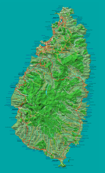
This is a list of cities, towns, and other inhabited places in the 10 districts of the island country of Saint Lucia. There are 150 inhabited places in Saint Lucia. The significant cities and the district where they are located are listed below. [1]
This is a list of cities, towns, and other inhabited places in the 10 districts of the island country of Saint Lucia. There are 150 inhabited places in Saint Lucia. The significant cities and the district where they are located are listed below. [1]
The following are the significant cities in Saint Lucia: [2]

Saint Lucia is an island country in the West Indies in the eastern Caribbean Sea on the boundary with the Atlantic Ocean. The island was previously called Iyonola, the name given to the island by the native Arawaks, and later Hewanorra, the name given by the native Caribs, two separate Amerindian peoples. Part of the Windward Islands of the Lesser Antilles, it is located north/northeast of the island of Saint Vincent, northwest of Barbados and south of Martinique. It covers a land area of 617 km2 and reported a population of 165,595 in the 2010 census. St. Lucia's largest city is Castries, its current capital, and its second largest is Soufrière, the first French colonial capital on the island.

Castries is the capital and largest city of Saint Lucia, an island country in the Caribbean. The urban area had the population of approximately 20,000, while the eponymous district had a population of 70,000 on 22 May 2013. The city stretches over an area of 80 km2 (31 sq mi).

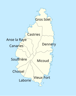
Vieux Fort is one of 10 districts of the Caribbean island country of Saint Lucia. Vieux Fort is also the name of the main town in the district. It is the home of the second-largest town in Saint Lucia and is the home of Saint Lucia's international airport, Hewanorra International Airport.

Dennery District is one of 10 districts of the Caribbean island nation of Saint Lucia. The seat of Dennery District is the Dennery Village. The main economic activities are fishing, and the cultivation of lima beans, bananas, and other tropical fruit. The population of the quarter was estimated at 12,876 in 2002 and fell to 12,767 in 2010.
Anse la Raye District is one of 10 districts of the island nation of St. Lucia in the Caribbean Sea. The name Anse la Raye is French for cover/bay of the rays, since there are a large number of skate fish or rays in the bay. In 2005/2010, the population of the district was 6,382/6,060 people, and they are mainly fishers and agricultural workers. The main town in the area takes the same name as the district and is located down the western coast from Castries, the capital of the country.
The island nation of Saint Lucia is divided into 10 districts. The name Quarters or Quartiers originally came from the French period in Saint Lucia. The 2001 and 2010 Census of Saint Lucia refers to the first level administrative divisions as districts. The FIPS and ISO standards regularly called these divisions quarters or quartiers in French. The former district of Dauphin Quarter was merged into Gros Islet District and the former district of Praslin Quarter was merged into Micoud District.
Choiseul District is one of the 10 districts of the Caribbean island nation of Saint Lucia. Located on the southwestern side of the island, the district is home to 6,130 people, according to the 2019 census. The seat of Choiseul District is the town of Choiseul.
Micoud District is one of 10 districts of the Caribbean island nation of Saint Lucia The seat of this district is the town of Micoud inside this district. According to the 2002 census, the population of the district was 16,143 people. The final 2010 Census recorded a population of 16,284 in Micoud District. A former quarter, Praslin Quarter, was merged into Micoud Quarter. It was not enumerated separately in the 2010 Census. The 2001 Census shows Praslin as part of Micoud District.

Praslin Quarter was a former quarter on the island nation of Saint Lucia. Since at least 2001, it has been a second-order subdivision of the Micoud District. The 2001 and 2010 Census show Praslin as part of the Micoud District. The population of Praslin is 341.

Castries District is one of 10 districts of the Caribbean island nation of Saint Lucia. According to the 2012 census, the population of the district was 80,573, having shown a slow but steady increase over the past ten years. The capital of Saint Lucia, the city of Castries, is located in this district. During the Saint Lucia Jazz Festival, the city of Castries plays host to several stages.

The House of Assembly is the lower house of the Parliament of Saint Lucia, elected by popular vote. The upper house is the Senate. It has 17 or 18 members: 17 members elected for a five-year term in single-seat constituencies, and a speaker elected by the 17 members, who may be one of their number or a person chosen from outside the House. To be elected to the house, a person must be at least 21 years old.

Saint Lucia, an island nation in the Caribbean islands, has a relatively large and lucrative tourism industry. Due to the relatively small land area of the country, most of the governmental promotion is performed by the state-operated Saint Lucia Tourism Authority, led by Executive Chairperson Agnes.

Canaries is a populated place located on the West Coast of Saint Lucia in the Canaries Quarter. It is a small fishing village and it is nestled along the West Coast road, between the towns of Anse La Raye and Soufriere, and there are scenic views from both the Northern and Southern approaches.
Trois Pitons is a second-order administrative division and populated place in the Castries District of the island nation of Saint Lucia. it is located at the northern end of the island towards its heart, near Four Roads Junction, Dubrassay, and Ti Rocher.
Sarot is a town in the Sarot second-order division of the Castries District of the island nation of Saint Lucia. The Sarot division has a population of 690. Sarot is located towards the heart of the island, between Vanard and Durandeau and close to Morne Ciseaux and La Treille.
Vieux Fort is a town located near the southernmost point of Saint Lucia, a Caribbean island nation. It is named after a fort that used to watch out towards Saint Vincent towards the south. The population of the town was 4,574 in 2010, while the surrounding district of Vieux Fort has a total population of about 15,132 in 2010.
The COVID-19 pandemic in Saint Lucia is part of the ongoing global viral pandemic of coronavirus disease 2019 (COVID-19), which was confirmed to have reached Saint Lucia on 13 March 2020. As of 8 May 2022, there are a total of 23,778 confirmed cases, of which 22,621 have recovered and 368 deaths have occurred.

This bibliography of Saint Lucia is a list of English-language nonfiction books which have been described by reliable sources as in some way directly relating to the subject of Saint Lucia, its history, geography, people, culture, etc.
