This is a list of road/highway and rail crossings of the Raritan River from the mouth at Raritan Bay upstream. It also includes crossings of its two branches: the North Branch Raritan River and the South Branch Raritan River.
This is a list of road/highway and rail crossings of the Raritan River from the mouth at Raritan Bay upstream. It also includes crossings of its two branches: the North Branch Raritan River and the South Branch Raritan River.

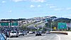
Route 31 is a state highway in New Jersey, United States. It runs 48.93 mi (78.75 km) from U.S. Route 1 Business /US 206 in Trenton, Mercer County, north to an intersection with US 46 in Buttzville in White Township, Warren County. Along the way, Route 31 heads through the communities of Flemington, Clinton, and Washington. Most of the highway is state-maintained; however, the section within the city limits of Trenton is maintained by the city. Much of Route 31 is a two-lane highway that passes through farmland, woodland, and mountainous areas. Two portions of the route—from Trenton to Pennington and from Ringoes to Clinton—consist of more development.

Raritan River is a major river of New Jersey. Its watershed drains much of the mountainous area of the central part of the state, emptying into the Raritan Bay on the Atlantic Ocean.

The South Branch Raritan River is a 50-mile-long (80 km) tributary of the Raritan River in New Jersey.

The North Branch Raritan River is a tributary of the Raritan River in central New Jersey.

The Millstone River is a 38.6-mile-long (62.1 km) tributary of the Raritan River in central New Jersey in the United States.
County Route 567 is a county highway in the U.S. state of New Jersey. The highway extends 10.02 miles (16.13 km) from Amwell Road in Hillsborough Township to Union Avenue in Raritan Borough.

Schooley's or, officially, Schooleys Mountain is a mountain ridge in northern New Jersey that stretches from Lake Hopatcong in the north to Hampton in the south. It is centrally located within the southern Highlands, positioned almost equidistantly from the Kittatinny Valley in the west and the Piedmont plateau in the east. Schooley's Mountain is also one of the largest ridges in a group of geologically similar and parallel mountains, which include Allamuchy Mountain, Pohatcong Mountain, Scotts Mountain, and Jenny Jump Mountain.

The Raritan Bay Drawbridge, also known as River-Draw, Raritan Bay Swing Bridge, and Raritan River Railroad Bridge, is a railroad swing bridge crossing the Raritan River 0.5 miles (0.8 km) from where it empties into the Raritan Bay in Middlesex County, New Jersey, United States. It connects Perth Amboy to the north and South Amboy to the south.

County Route 523 is a county highway in the U.S. state of New Jersey. The highway extends 29.55 miles (47.56 km) from Route 29 in Stockton to U.S. Route 202 (US 202) in Bedminster Township.

County Route 512 is a county highway in the U.S. state of New Jersey. The highway extends 32.96 miles (53.04 km) from High Bridge Road in Califon to Springfield Avenue / Route 24 in Summit.
County Route 509 is a county highway in the U.S. state of New Jersey. The highway exists in two segments– one 0.95-mile (1.53 km) unsigned segment exists in northern Middlesex County while the signed mainline extends 25.78 miles (41.49 km) from North Avenue in Westfield to Straight Street in Paterson.

Holland Brook is a tributary of the South Branch Raritan River in Hunterdon and Somerset Counties, New Jersey in the United States.

Ten Mile Run is a tributary of the Millstone River, draining an area in southern South Brunswick and southern Franklin Park, New Jersey in the United States.

Readingsburg, also known as Stone Mill, is an unincorporated community located along the South Branch Raritan River within Clinton Township in Hunterdon County, New Jersey.

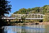
Rockefellows Mills is an unincorporated community located within Raritan Township in Hunterdon County, New Jersey, United States. The settlement is located along the South Branch Raritan River near Three Bridges. The river is spanned in the area by the historic Rockafellows Mill Bridge built in 1900 and part of the Raritan–Readington South Branch Historic District. Most of the area within the Raritan Township side of the river is forested however on the north side of the river in Readington Township, some farmland dots the area.

The Main Street Bridge, once known as the West Main Street Bridge, is a historic pony Pratt truss bridge crossing the South Branch Raritan River in Clinton of Hunterdon County, New Jersey. It was designed by Francis C. Lowthorp and built in 1870 by William Cowin of Lambertville. The bridge was added to the National Register of Historic Places on September 28, 1995 as part of the Clinton Historic District. It is one of the few early examples of iron Pratt truss bridges remaining in the United States. It was documented by the Historic American Engineering Record in 1991.
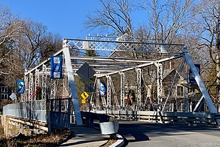
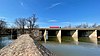
The Main Street Bridge, historically known as the Califon Bridge, is a Pratt thru truss bridge that carries Main Street over the South Branch Raritan River in Califon, Hunterdon County, New Jersey. The bridge was added to the National Register of Historic Places on October 14, 1976 as part of the Califon Historic District.
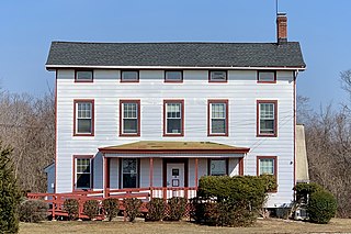
The Raritan–Readington South Branch Historic District is a 556-acre (225 ha) historic district along River Road from New Jersey Route 31 to U.S. Route 202 near Flemington in Hunterdon County, New Jersey. It is primarily on the western side of the South Branch Raritan River in Raritan Township. It extends onto the eastern side of the river in Readington Township. County Route 523 and County Route 612 pass through the district to the north. The district encompasses the small settlements of Holcomb Mills, Flemington Junction, and Rockefellows Mills. It was added to the National Register of Historic Places on January 26, 1990, for its significance in architecture, politics, transportation, and exploration/settlement. The district includes 36 contributing buildings, four contributing structures, and three contributing sites. It also includes the John Reading Farmstead, previously listed on the NRHP individually.

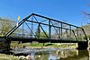
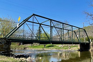
The Rockafellows Mill Bridge is a one-lane Pratt thru truss bridge that carries Rockafellows Mill Road over the South Branch Raritan River in Rockefellows Mills, Hunterdon County, New Jersey. The bridge was added to the National Register of Historic Places on January 26, 1990, as part of the Raritan–Readington South Branch Historic District.
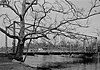
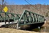
The Hoffman's Crossing Road Bridge is a Pratt thru truss bridge that carries Hoffman's Crossing Road across the South Branch Raritan River in the Hoffmans section of Lebanon Township in Hunterdon County, New Jersey. It was built in 1898 by Tippett and Wood of Phillipsburg. The bridge is 103 feet (31 m) long and 16.2 feet (4.9 m) wide. It was added to the New Jersey Register of Historic Places on February 11, 1999.