Related Research Articles
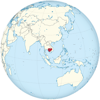
Cambodia is a country in mainland Southeast Asia, border Thailand, Laos, Vietnam, the Gulf of Thailand and covers a total area of 181,035 km2 (69,898 sq mi). The country is situated in its entirety inside the tropical Indomalayan realm and the Indochina Time zone (ICT).

The Mekong or Mekong River is a trans-boundary river in East Asia and Southeast Asia. It is the world's twelfth longest river and the sixth longest in Asia. Its estimated length is 4,909 km (3,050 mi), and it drains an area of 795,000 km2 (307,000 sq mi), discharging 475 km3 (114 cu mi) of water annually. From the Tibetan Plateau the river runs through China, Myanmar, Laos, Thailand, Cambodia, and Vietnam. The extreme seasonal variations in flow and the presence of rapids and waterfalls in the Mekong make navigation difficult. Even so, the river is a major trade route between western China and Southeast Asia.
The Global 200 is the list of ecoregions identified by WWF, the global conservation organization, as priorities for conservation. According to WWF, an ecoregion is defined as a "relatively large unit of land or water containing a characteristic set of natural communities that share a large majority of their species dynamics, and environmental conditions". So, for example, based on their levels of endemism, Madagascar gets multiple listings, ancient Lake Baikal gets one, and the North American Great Lakes get none.

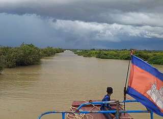
Tonlé Sap is a seasonally inundated freshwater lake, Tonlé Sap Lake, and an attached river, the 120 km (75 mi) long Tonlé Sap River, that connects the lake to the Mekong River. They form the central part of a complex hydrological system, in the 12,876 km2 (4,971 sq mi) Cambodian floodplain covered with a mosaic of natural and agricultural habitats that the Mekong replenishes with water and sediments annually. The central plain formation is the result of millions of years of Mekong alluvial deposition and discharge. From a geological perspective, the Tonlé Sap Lake and Tonlé Sap River are a current freeze-frame representation of the slowly but continuously shifting lower Mekong basin. Annual fluctuation of the Mekong's water volume, supplemented by the Asian monsoon regime, causes a unique flow reversal of the Tonlé Sap River. The largest freshwater lake in Southeast Asia, it contains an exceptional large variety of interconnected eco-regions with a high degree of biodiversity and is therefore a biodiversity hotspot. It was designated a UNESCO biosphere reserve in 1997.

Freshwater swamp forests, or flooded forests, are forests which are inundated with freshwater, either permanently or seasonally. They normally occur along the lower reaches of rivers and around freshwater lakes. Freshwater swamp forests are found in a range of climate zones, from boreal through temperate and subtropical to tropical.

The Greater Mekong Subregion, (GMS) or just Greater Mekong, is a trans-national region of the Mekong River basin in Southeast Asia. The region is home to more than 300 million people. It came into being with the launch of a development program in 1992 by the Asian Development Bank that brought together the six Asian countries of Cambodia, China, Laos, Myanmar (Burma), Thailand, and Vietnam.

The Southeastern Indochina dry evergreen forests are a tropical dry broadleaf forest ecoregion of Indochina.
Natural resources are materials that occur in a natural form within environments. These can be classified as either biotic or abiotic on the basis of their origin. The landmass and the territorial waters of Cambodia contain a rather moderate amount, array and variety of resources. Apart from water, abiotic resources, such as minerals are generally rare. Still, advanced geo-scientific technologies have produced remarkable results and re-assessments in recent years, such as the localization of offshore oil and gas depots in the Gulf of Thailand. Cambodia, on the other hand possesses a relatively wide range of biotic resources, in particular timber, forest products, rare plants and a fauna of great diversity.
The Central Indochina dry forests are a large tropical and subtropical dry broadleaf forests ecoregion in Southeast Asia.
This page describes energy and electricity production, consumption and import in Laos.
Brachygobius mekongensis is a species of goby from the subfamily Gobionellinae which is found in the Mekong basin in southern Vietnam, Thailand, Cambodia and Laos where it lives in slow flowing waters and swamps among tangled roots and vegetation. This species is infrequently recorded in the aquarium trade and is potentially threatened by degradation of its habitat by drainage, water diversion and the building of dams and bridges.
Parachela siamensis is a small species of freshwater ray-finned fish in the carp and minnow family Cyprinidae.
Paralaubuca typus is a species of freshwater ray-finned fish from the carp and minnow family Cyprinidae from south-east Asia. It is found in Thailand in the basins of the Chao Phraya, Tapi, Mekong and Mae Klong and in the Mekong on Laos and Cambodia, as well as Vietnam where it is also found in the La Ngà River. It is one of the most abundant fish species in the lower Mekong.
Senegalia thailandica is a species of climbing or sprawling shrub in the family Fabaceae.
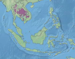
The Tonle Sap freshwater swamp forests ecoregion covers the seasonally flooded forests surrounding Tonlé Sap, the largest lake in Cambodia, and the floodplains of its connections to the Mekong River. Over 35% of the ecoregion experiences flooding during the wet season.

The Tonle Sap-Mekong peat swamp forests ecoregion covers a patchwork of areas permanently inundated with fresh water along the Tonle Sap River and Mekong River floodplains in Cambodia and Vietnam. The terrain is mostly flat, with extensive agricultural fields, reed beds, and degraded shrub forest. Less than 10% of the region is in its original state, and less than 1% is protected. Habitat in the region is distinguished from the Tonle Sap freshwater swamp forests ecoregion that runs through the middle, as that ecoregion is only seasonally flooded.
References
- Wikramanayake, Eric; Eric Dinerstein; Colby J. Loucks; et al. (2002). Terrestrial Ecoregions of the Indo-Pacific: a Conservation Assessment. Washington, DC: Island Press
| History |  | ||||
|---|---|---|---|---|---|
| Geography | |||||
| Politics | |||||
| Economy | |||||
| Society |
| ||||