The following is a list of ecoregions in Myanmar (also known as Burma). [1] [2]
Myanmar is in the Indomalayan realm. ecoregions are listed by biome. [3]
Myanmar's seas are in the Western Indo-Pacific marine realm. [5] Myanmar's two marine ecoregions are:

Myanmar is the northwesternmost country of mainland Southeast Asia located on the Indochinese peninsula. With an area of 261,228 sq mi, it is the second largest country in Southeast Asia and the largest on mainland Southeast Asia. The kite-shaped country stretches from 10'N to 20'N for 1,275 miles (2,050 km) with a long tail running along the western coast of the Malay Peninsula.
The Global 200 is the list of ecoregions identified by the World Wide Fund for Nature (WWF), the global conservation organization, as priorities for conservation. According to WWF, an ecoregion is defined as a "relatively large unit of land or water containing a characteristic set of natural communities that share a large majority of their species dynamics, and environmental conditions". For example, based on their levels of endemism, Madagascar gets multiple listings, ancient Lake Baikal gets one, and the North American Great Lakes get none.

Dendrocalamus is a tropical Asian genus of giant clumping bamboos in the grass family. It is found in the Indian subcontinent, China, and Southeast Asia.

The Hengduan Mountains are a group of mountain ranges in southwest China that connect the southeast portions of the Tibetan Plateau with the Yunnan–Guizhou Plateau. The Hengduan Mountains are primarily large north-south mountain ranges that effectively separate lowlands in northern Myanmar from the lowlands of the Sichuan Basin. These ranges are characterized by significant vertical relief originating from the Indian subcontinent's collision with the Eurasian Plate, and further carved out by the major rivers draining the eastern Tibetan Plateau. These rivers, the Yangtze, Mekong, and Salween, are recognized today as the Three Parallel Rivers UNESCO World Heritage Site.

Indo-Burma is a biodiversity hotspot designated by Conservation International.

The Eastern Himalayan broadleaf forests is a temperate broadleaf forest ecoregion found in the middle elevations of the eastern Himalayas, including parts of Nepal, India, Bhutan, Myanmar and China. These forests have an outstanding richness of wildlife.

The Eastern Himalayan alpine shrub and meadows is a montane grasslands and shrublands ecoregion of Bhutan, China, India, Myanmar, and Nepal, which lies between the tree line and snow line in the eastern portion of the Himalaya Range.

The Northern Triangle temperate forests is a temperate broadleaf and mixed forest ecoregion of thick forest covering the mountains of northern Myanmar.
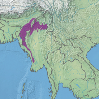
The Mizoram–Manipur–Kachin rain forests is a subtropical moist broadleaf forest ecoregion which occupies the lower hillsides of the mountainous border region joining India, Bangladesh, and Burma (Myanmar) and China's Yunnan Province. The ecoregion covers an area of 135,600 square kilometres (52,400 sq mi). Located where the biotas of the Indian Subcontinent and Indochina meet, and in the transition between subtropical and tropical regions of Asia, the Mizoram–Manipur–Kachin rain forests are home to great biodiversity. The WWF rates the ecoregion as "Globally Outstanding" in biological distinctiveness.

The Nujiang Lancang Gorge alpine conifer and mixed forests are a temperate coniferous forests ecoregion in Southwest China and northeastern Myanmar. The forests cover mountains and valleys in the western Hengduan Mountains and because of the extreme topography and relative remoteness, remain one of the best preserved habitats in China.

The Irrawaddy moist deciduous forests is a tropical moist broadleaf forest ecoregion in central Myanmar. The ecoregion occupies the central basin of the Irrawaddy River and the lower basin of the Salween River. The ecoregion is characterized by forests of tall trees which drop their leaves in the dry season. Most of the ecoregion's forests have been converted to agriculture.

The Myanmar coastal rain forests is a tropical moist broadleaf forest ecoregion in Myanmar. The ecoregion occupies Myanmar's coastal lowlands along the Bay of Bengal and Andaman Sea.

The Luang Prabang montane rain forests ecoregion covers elevations over 800 meters in the Luang Prabang mountains that straddle the border between northern Thailand and north-central Laos, and the highlands that stretch eastward across north-central Laos. While much of the forest cover has been degraded, there are still large areas of relatively untouched forest.
The Northern Thailand–Laos moist deciduous forests ecoregion follows the upper course of the Nan River in northern Thailand and the Mekong River in Laos. This area has the highest proportion of tree cover in Thailand, with many forests dominated by Teak. The river valleys have been under pressure from human use: agriculture, teak plantations, and hunting have reduce plant and animal presence.

The Northern Triangle subtropical forests ecoregion covers remote, mountainous terrain in the far north of Myanmar. Due to the regions isolation it is relatively untouched and unexplored by humans. Over 95% of the ecoregion is covered with closed evergreen forest, and importantly for conservation, these forests exist in large contiguous blocks. As of the late 1990s, 140 mammal species were known to be in the region, and new species, such the Leaf muntjac discovered in 1997, are still being found.
List of ecoregions in Asia | |
|---|---|
| Sovereign states |
|
| States with limited recognition | |
| Dependencies and other territories | |