
This is a list of the 50 highest mountains in Wales. The Welsh mountains are ranked highest first.
This is a list of the 50 highest mountains in Wales. The Welsh mountains are ranked highest first.
| Rank | Name (Welsh name) | Image | Height [1] | Mountain range (Welsh name) | National Park (Welsh name) |
|---|---|---|---|---|---|
| 1 | Snowdon (Yr Wyddfa) |  | 1,085 m (3,560 ft) [2] | Snowdon Massif (Mynyddoedd Yr Wyddfa) | Snowdonia (Eryri) |
| 2 | Garnedd Ugain |  | 1,065 m (3,494 ft) | Snowdon Massif (Mynyddoedd Yr Wyddfa) | Snowdonia (Eryri) |
| 3 | Carnedd Llewelyn |  | 1,064 m (3,491 ft) [2] | Carneddau | Snowdonia (Eryri) |
| 4 | Carnedd Dafydd |  | 1,044 m (3,425 ft) | Carneddau | Snowdonia (Eryri) |
| 5 | Glyder Fawr |  | 999 m (3,278 ft) [2] | Glyderau | Snowdonia (Eryri) |
| 6 | Glyder Fach |  | 994 m (3,261 ft) | Glyderau | Snowdonia (Eryri) |
| 7 | Pen yr Ole Wen |  | 978 m (3,209 ft) | Carneddau | Snowdonia (Eryri) |
| 8 | Foel Grach |  | 976 m (3,202 ft) | Carneddau | Snowdonia (Eryri) |
| 9 | Yr Elen |  | 962 m (3,156 ft) | Carneddau | Snowdonia (Eryri) |
| 10 | Y Garn |  | 947 m (3,107 ft) [2] | Glyderau | Snowdonia (Eryri) |
| 11 | Foel Fras |  | 942 m (3,091 ft) | Carneddau | Snowdonia (Eryri) |
| 12 | Carnedd Gwenllian |  | 926 m (3,038 ft) | Carneddau | Snowdonia (Eryri) |
| 13 | Elidir Fawr |  | 924 m (3,031 ft) [2] | Glyderau | Snowdonia (Eryri) |
| 14 | Crib Goch |  | 923 m (3,028 ft) | Snowdon Massif (Mynyddoedd Yr Wyddfa) | Snowdonia (Eryri) |
| 15 | Tryfan |  | 915 m (3,002 ft) [2] | Glyderau | Snowdonia (Eryri) |
| 16 | Aran Fawddwy |  | 905 m (2,969 ft) [2] | Aran | Snowdonia (Eryri) |
| 17 | Y Lliwedd |  | 898 m (2,946 ft) [2] | Snowdon Massif (Mynyddoedd Yr Wyddfa) | Snowdonia (Eryri) |
| 18 | Y Lliwedd East Peak |  | 893 m (2,930 ft) | Snowdon Massif (Mynyddoedd Yr Wyddfa) | Snowdonia (Eryri) |
| 19 | Cadair Idris |  | 893 m (2,930 ft) [2] | Cadair Idris | Snowdonia (Eryri) |
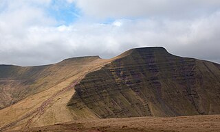
| 20 | Pen y Fan | 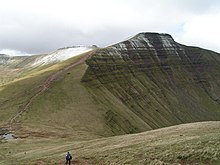 | 886 m (2,907 ft) [2] | Brecon Beacons (Bannau Brycheiniog) | Brecon Beacons (Bannau Brycheiniog) |
| 21 | Aran Benllyn |  | 885 m (2,904 ft) | Aran | Snowdonia (Eryri) |
| 22 | Corn Du |  | 873 m (2,864 ft) | Brecon Beacons (Bannau Brycheiniog) | Brecon Beacons (Bannau Brycheiniog) |
| 23 | Erw y Ddafad-ddu |  | 872 m (2,861 ft) | Aran | Snowdonia (Eryri) |
| 24 | Moel Siabod |  | 872 m (2,861 ft) | Moelwynion | Snowdonia (Eryri) |
| 25 | Mynydd Moel |  | 863 m (2,831 ft) | Cadair Idris | Snowdonia (Eryri) |
| 26 | Arenig Fawr |  | 854m (2,802 ft) | Arenig | Snowdonia (Eryri) |
| 27 | Llwytmor |  | 849m (2,785 ft) | Carneddau | Snowdonia (Eryri) |
| 28 | Pen yr Helgi Du |  | 833m (2,733 ft) | Carneddau | Snowdonia (Eryri) |
| 29 | Foel-goch |  | 831m (2,726 ft) | Glyderau | Snowdonia (Eryri) |
| 30 | Arenig Fawr(south peak) |  | 830m (2723 ft) | Arenig | Snowdonia (Eryri) |
| 31 | Cadair Berwyn |  | 830m (2723 ft) | Berwyn | none |
| 32 | Cadair Berwyn(north peak) |  | 827m (2713 ft) | Berwyn | none |
| 33 | Moel Sych |  | 827m (2713 ft) | Berwyn | none |
| 34 | Carnedd y Filiast |  | 821m (2694 ft) | Glyderau | Snowdonia (Eryri) |
| 35 | Lliwedd Bach |  | 818m (2684 ft) | Snowdon Massif (Mynyddoedd Yr Wyddfa) | Snowdonia (Eryri) |
| 36 | Mynydd Perfedd |  | 812m (2664 ft) | Glyderau | Snowdonia (Eryri) |
| 37 | Cyfrwy |  | 811m (2661 ft) | Cadair Idris | Snowdonia (Eryri) |
| 38 | Waun Fach |  | 811m (2661 ft) | Black Mountains | Brecon Beacons (Bannau Brycheiniog) |
| 39 | Bera Bach |  | 807m (2648 ft) | Carneddau | Snowdonia (Eryri) |
| 40 | Y Foel Goch |  | 805m (2641 ft) | Glyderau | Snowdonia (Eryri) |
| 41 | Fan Brycheiniog |  | 802m (2631 ft) | Brecon Beacons (Bannau Brycheiniog) | Brecon Beacons (Bannau Brycheiniog) |
| 42 | Pen y Gadair Fawr |  | 800m (2625 ft) | Black Mountains | Brecon Beacons (Bannau Brycheiniog) |
| 43 | Pen Llithrig y Wrach |  | 799m (2621 ft) | Carneddau | Snowdonia (Eryri) |
| 44 | Foel Meirch |  | 795m (2608 ft) | Carneddau | Snowdonia (Eryri) |
| 45 | Cribyn |  | 795m (2608 ft) | Brecon Beacons (Bannau Brycheiniog) | Brecon Beacons (Bannau Brycheiniog) |
| 46 | Bera Mawr |  | 794m (2605 ft) | Carneddau | Snowdonia (Eryri) |
| 47 | Craig Cwm Amarch |  | 791m (2595 ft) | Cadair Idris | Snowdonia (Eryri) |
| 48 | Cadair Bronwen |  | 785m (2575 ft) | Berwyn | none |
| 49 | Moel Hebog |  | 783m (2569 ft) | Hebog | Snowdonia (Eryri) |
| 50 | Glasgwm |  | 780m (2559 ft) | Aran | Snowdonia (Eryri) |

Snowdonia, or Eryri, is a mountainous region and national park in North Wales. It contains all 15 mountains in Wales over 3000 feet high, including the country's highest, Snowdon, which is 1,085 metres (3,560 ft) tall. These peaks are all part of the Snowdon, Glyderau, and Carneddau ranges in the north of the region. The shorter Moelwynion and Moel Hebog ranges lie immediately to the south.

Gwynedd is a county in the north-west of Wales. It borders Anglesey across the Menai Strait to the north, Conwy, Denbighshire, and Powys to the east, Ceredigion over the Dyfi estuary to the south, and the Irish Sea to the west. The city of Bangor is the largest settlement, and the administrative centre is Caernarfon. The preserved county of Gwynedd, which is used for ceremonial purposes, includes the Isle of Anglesey.
The Brecon Beacons are a mountain range in Wales. The range includes South Wales's highest mountain, Pen y Fan, its twin summit Corn Du, and Craig Gwaun Taf, which are the three highest peaks in the range. The Brecon Beacons have given their name to the larger Brecon Beacons National Park, and the range itself is therefore sometimes known as the Central Beacons to differentiate the two.

Mount Kosciuszko is mainland Australia's tallest mountain, at 2,228 metres (7,310 ft) above sea level. It is located on the Main Range of the Snowy Mountains in Kosciuszko National Park, part of the Australian Alps National Parks and Reserves, in New South Wales, Australia, and is located west of Crackenback and close to Jindabyne, near the border with Victoria. Mount Kosciuszko is ranked 35th by topographic isolation.

Snowdon, or Yr Wyddfa, is a mountain in the Snowdonia region of North Wales. It has an elevation of 1,085 metres (3,560 ft) above sea level, which makes it both the highest mountain in Wales and the highest in the British Isles south of the Scottish Highlands. Snowdon is designated a national nature reserve for its rare flora and fauna, and is located within Snowdonia National Park.

Mount Whitney is the highest mountain in the contiguous United States and the Sierra Nevada, with an elevation of 14,505 feet (4,421 m). It is in East–Central California, on the boundary between California's Inyo and Tulare counties, and 84.6 miles (136.2 km) west-northwest of North America's lowest point, Badwater Basin in Death Valley National Park, at 282 ft (86 m) below sea level. The mountain's west slope is in Sequoia National Park and the summit is the southern terminus of the John Muir Trail, which runs 211.9 mi (341.0 km) from Happy Isles in Yosemite Valley. The eastern slopes are in Inyo National Forest in Inyo County. Mount Whitney is ranked 18th by topographic isolation.

Mount Columbia is a mountain located in the Winston Churchill Range of the Rocky Mountains. It is the highest point in Alberta, Canada, and is second only to Mount Robson for height and topographical prominence in the Canadian Rockies. It is located on the border between Alberta and British Columbia on the northern edge of the Columbia Icefield. Its highest point, however, lies within Jasper National Park in Alberta.

The Australian Alps are a mountain range in southeast Australia. The range comprises an interim Australian bioregion, and is the highest mountain range in Australia. The range straddles the borders of eastern Victoria, southeastern New South Wales, and the Australian Capital Territory. It contains Australia's only peaks exceeding 2,000 m (6,600 ft) in elevation, and is the only bioregion on the Australian mainland in which deep snow falls annually. The range comprises an area of 1,232,981 ha.
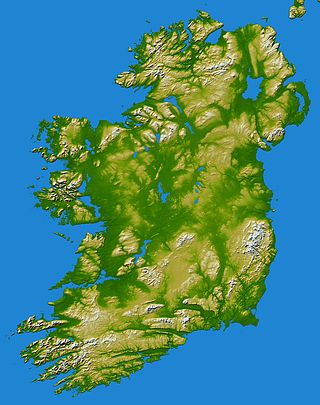
In these lists of mountains in Ireland, those within Northern Ireland, or on the Republic of Ireland – United Kingdom border, are marked with an asterisk, while the rest are within the Republic of Ireland. Where mountains are ranked by height, the definition of the topographical prominence used to classify the mountain, is noted. In British definitions, a height of 600 metres (1,969 ft) is required for a mountain, whereas in Ireland, a lower threshold of 500 metres (1,640 ft) is sometimes advocated.

Pen y Fan is the highest peak in South Wales, situated in Brecon Beacons National Park. At 886 metres (2,907 ft) above sea-level, it is also the highest British peak south of Cadair Idris in Snowdonia. It is the highest point of the historic county of Brecknockshire. The twin summits of Pen y Fan and Corn Du at 873 metres (2,864 ft) were formerly referred to as Cadair Arthur or 'Arthur's Seat'.

Aran Fawddwy is a mountain in southern Snowdonia, Wales, United Kingdom. It is the highest point of the historic county of Merionethshire. It is the highest peak in the Aran mountain range, the only peak in Wales outside North Snowdonia above 900m, and higher than anywhere in the United Kingdom outside Northern Snowdonia, the Scottish Highlands and the Lake District. The nearest small settlements to the mountain are Dinas Mawddwy to the south, Llanymawddwy to the southeast, Llanuwchllyn on the shores of Bala Lake to the north, and Rhydymain to the west. The nearest settlements with around 2,000 people are Bala and Dolgellau. On the eastern slopes of Aran Fawddwy is the small lake named Creiglyn Dyfi, the source of the River Dyfi. Its sister peak is Aran Benllyn at 885 metres (2,904 ft). There is also a middle peak: Erw y Ddafad-ddu.
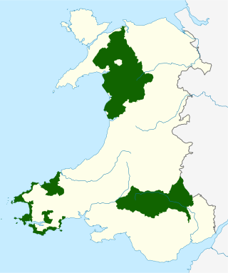
The national parks of Wales are managed areas of outstanding landscape in Wales, United Kingdom where some forms of development are restricted to preserve the landscape and natural environment. Together, they cover 20% of the land surface of Wales and have a resident population of over 80,000 people. Each National Park Authority is a free-standing body within the local government framework.
Sugarloaf Mountain is the fifth-highest named point and the most prominent point in the U.S. state of Florida. At 312 feet above sea level it is also the highest point on the geographic Florida Peninsula. The hill is in Lake County, near the town of Clermont.

England comprises most of the central and southern two-thirds of the island of Great Britain, in addition to a number of small islands of which the largest is the Isle of Wight. England is bordered to the north by Scotland and to the west by Wales. It is closer to continental Europe than any other part of mainland Britain, divided from France only by a 33 km (21 mi) sea gap, the English Channel. The 50 km (31 mi) Channel Tunnel, near Folkestone, directly links England to mainland Europe. The English/French border is halfway along the tunnel.

The mountains and hills of the British Isles are categorised into various lists based on different combinations of elevation, prominence, and other criteria such as isolation. These lists are used for peak bagging, whereby hillwalkers attempt to reach all the summits on a given list, the oldest being the 282 Munros in Scotland, created in 1891.
Chiricahua Peak is a 9,773 feet (2,979 m) peak located in the Chiricahua Mountains of southeastern Arizona, located about 35 miles (56 km) north of the United States–Mexico border. It is the highest summit in the Chiricahua Mountains and the highest point in Cochise County.
Commonwealth Mountain is a mountain on Ellesmere Island, Nunavut, Canada. It lies in western Quttinirpaaq National Park, which is the most northerly extent of Canada, and is the second most northerly park on Earth after Northeast Greenland National Park.
| Tourism organisations and projects |
| ||||
|---|---|---|---|---|---|
| Lists of attractions |
| ||||
| Publications and tours | |||||
| Other related articles | |||||