Related Research Articles

A hillfort is a type of earthwork used as a fortified refuge or defended settlement, located to exploit a rise in elevation for defensive advantage. They are typically European and of the Bronze Age or Iron Age. Some were used in the post-Roman period. The fortification usually follows the contours of a hill and consists of one or more lines of earthworks, with stockades or defensive walls, and external ditches. Hillforts developed in the Late Bronze and Early Iron Age, roughly the start of the first millennium BC, and were used in many Celtic areas of central and western Europe until the Roman conquest.
This is a list of the extreme points of Ireland – the points that are farthest north, south, east or west in Ireland. It includes the Republic of Ireland and Northern Ireland.
Holborn Head is a headland on the north-facing Atlantic coast of Caithness, in the Highland area of Scotland. The point of Holborn Head is at 58°37′23″N03°32′06″W. It has a lighthouse at its south end and the remains of an old fort at its tip.

The Grianan of Aileach, sometimes anglicised as Greenan Ely or Greenan Fort, is a hillfort atop the 244 metres (801 ft) high Greenan Mountain at Inishowen in County Donegal, Ireland. The main structure is a stone ringfort, thought to have been built by the Northern Uí Néill, in the sixth or seventh century CE; although there is evidence that the site had been in use before the fort was built. It has been identified as the seat of the Kingdom of Ailech and one of the royal sites of Gaelic Ireland. The wall is about 4.5 metres (15 ft) thick and 5 metres (16 ft) high. Inside it has three terraces, which are linked by steps, and two long passages within it. Originally, there would have been buildings inside the ringfort. Just outside it are the remains of a well and a tumulus.
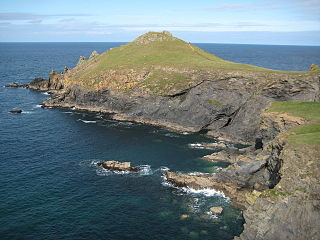
The Rumps is a twin-headland promontory at the north-east corner of Pentire Head in north Cornwall, United Kingdom.
Voley Castle is an Iron Age hill fort situated close to Parracombe in north Devon, England. The fort is situated on a promontory on the eastern side of Heale Down, approximately 230 metres (750 ft) above sea level. It is close to another Iron Age hill fort at Beacon Castle. Voley Castle is a slight univallate hillfort, a rare type of hill fort found mainly in Devon, and is unusual for its type because it has an outer earthwork.
Croft Ambrey is an Iron Age hill fort in Herefordshire, England.

Scratchbury Camp is the site of an Iron Age univallate hillfort on Scratchbury Hill, overlooking the Wylye valley about 1 km northeast of the village of Norton Bavant in Wiltshire, England. The fort covers an area of 37 acres (15 ha) and occupies the summit of the hill on the edge of Salisbury Plain, with its four-sided shape largely following the natural contours of the hill.
Hillforts in Britain refers to the various hillforts within the island of Great Britain. Although the earliest such constructs fitting this description come from the Neolithic British Isles, with a few also dating to later Bronze Age Britain, British hillforts were primarily constructed during the British Iron Age. Some of these were apparently abandoned in the southern areas that were a part of Roman Britain, although at the same time, those areas of northern Britain that remained free from Roman occupation saw an increase in their construction. Some hillforts were reused in the Early Middle Ages, and in some rarer cases, into the Later Medieval period as well. By the early modern period, these had essentially all been abandoned, with many being excavated by archaeologists in the nineteenth century onward.

Hillforts in Scotland are earthworks, sometimes with wooden or stone enclosures, built on higher ground, which usually include a significant settlement, built within the modern boundaries of Scotland. They were first studied in the eighteenth century and the first serious field research was undertaken in the nineteenth century. In the twentieth century there were large numbers of archaeological investigations of specific sites, with an emphasis on establishing a chronology of the forts. Forts have been classified by type and their military and ritual functions have been debated.

Torberry Hill is an Iron Age hillfort in the county of West Sussex, in southern England. It is a Scheduled Ancient Monument, with a list entry identification number of 1015966. The hill fort is located within the parish of Harting, within the South Downs National Park. The hill includes the remains of an Early Iron Age univallate hill fort, a Middle Iron Age promontory fort and a post-medieval post mill. The hill is a chalk spur projecting northwards from the South Downs.

Caesar's Camp is an Iron Age hill fort straddling the border of the counties of Surrey and Hampshire in southern England. The fort straddles the borough of Waverley in Surrey and the borough of Rushmoor and the district of Hart, both in Hampshire. Caesar's Camp is a Scheduled Ancient Monument with a list entry identification number of 1007895. It lies approximately 3 kilometres (1.9 mi) north of the town of Farnham, and a similar distance west of Aldershot. The hillfort lies entirely within the Bourley and Long Valley Site of Special Scientific Interest. Caesar's Camp is a multivallate hillfort, a fort with multiple defensive rings, occupying an irregular promontory, with an entrance on the south side. The site has been much disturbed by military activity, especially at the southeast corner. The remains of the hillfort are considered to be of national importance.
Bury Walls is an Iron Age hillfort about 1 mile (1.6 km) south-east of Weston-under-Redcastle, in Shropshire, England. It is a scheduled monument.

Jenny's Lantern is an area of moorland in north Northumberland, England, taking its name from an 18th-century 'eye-catcher' folly sited towards the top of a small promontory hill above the River Aln. Situated on the southern slope of the Jenny's Lantern area is an Iron Age hillfort, overbuilt by and adjoined to a larger and very well preserved Romano-British stone-built settlement and field system. It partially collapsed during a storm in November 2021.

Largin Castle is a contour hillfort and scheduled monument in Cornwall, England, presumed to date from the Iron Age.

Combs Moss is a plateau-topped hill between Chapel-en-le-Frith and Buxton in Derbyshire, in the Peak District. The summit, Combs Head, is 503 metres (1,650 ft) above sea level.
Ballyhogue or Ballyhoge is a village and census town in County Wexford, Ireland. The village, which lies in a townland and civil parish of the same name, had a population of 269 people as of the 2016 census.
References
- 1 2 Morris, Steven (2017-06-21). "Hill fort hotspots in UK and Ireland mapped for first time in online atlas". The Guardian. ISSN 0261-3077 . Retrieved 2017-07-27.
- ↑ Hawkes, Christopher (1931). "Hill-Forts". Antiquity. 5 (17): 60–97. doi:10.1017/S0003598X00005603. ISSN 0003-598X.
- ↑ Cunliffe, Barrington Windsor (1974). Iron Age Communities in Britain: an account of England, Scotland and Wales from the seventh century BC until the Roman conquest. London: Routledge. OCLC 819799871.
- ↑ Hamilton, Sue; Manley, John (2001). "Hillforts, monumentality and place: a chronological and topographic review of first millennium BC hillforts of south-east England". European Journal of Archaeology. 4 (1): 7–42. doi:10.1179/eja.2001.4.1.7. ISSN 1461-9571.
- ↑ "1510". Atlas of Hillforts of Britain and Ireland .
- ↑ "4360". Atlas of Hillforts of Britain and Ireland .
- ↑ "1482". Atlas of Hillforts of Britain and Ireland .
- ↑ "1495". Atlas of Hillforts of Britain and Ireland .
- ↑ "1493". Atlas of Hillforts of Britain and Ireland .
- ↑ "0789". Atlas of Hillforts of Britain and Ireland .
- ↑ "1483". Atlas of Hillforts of Britain and Ireland .
- ↑ "1485". Atlas of Hillforts of Britain and Ireland .
- ↑ "0808". Atlas of Hillforts of Britain and Ireland .
- ↑ "1488". Atlas of Hillforts of Britain and Ireland .
- ↑ "0806". Atlas of Hillforts of Britain and Ireland .
- ↑ "1489". Atlas of Hillforts of Britain and Ireland .
- ↑ "0807". Atlas of Hillforts of Britain and Ireland .
- ↑ "0805". Atlas of Hillforts of Britain and Ireland .
- ↑ "4354". Atlas of Hillforts of Britain and Ireland .
- ↑ "0786". Atlas of Hillforts of Britain and Ireland .
- ↑ "0662". Atlas of Hillforts of Britain and Ireland .
- ↑ "0791". Atlas of Hillforts of Britain and Ireland .
- ↑ "0810". Atlas of Hillforts of Britain and Ireland .
- ↑ "4361". Atlas of Hillforts of Britain and Ireland .
- ↑ "3057". Atlas of Hillforts of Britain and Ireland .
- ↑ "4355". Atlas of Hillforts of Britain and Ireland .
- ↑ "4356". Atlas of Hillforts of Britain and Ireland .
- ↑ "4357". Atlas of Hillforts of Britain and Ireland .
- ↑ "0811". Atlas of Hillforts of Britain and Ireland .
- ↑ "4363". Atlas of Hillforts of Britain and Ireland .
- ↑ "0813". Atlas of Hillforts of Britain and Ireland .
- ↑ "4364". Atlas of Hillforts of Britain and Ireland .
- ↑ "4362". Atlas of Hillforts of Britain and Ireland .
- ↑ "0788". Atlas of Hillforts of Britain and Ireland .
- ↑ "0812". Atlas of Hillforts of Britain and Ireland .
- ↑ "0814". Atlas of Hillforts of Britain and Ireland .