List of islands of Sri Lanka

Last updated

Sri Lanka Satellite image of Sri Lanka in May 2002.jpg
Sri Lanka
Pigeon Island Main Rock in Pigeon Island National Park.jpg
Pigeon Island
Nainativu Nainathivu.JPG
Nainativu
Bone Island, Batticaloa Bone Island, Batticaloa.jpg
Bone Island, Batticaloa
Kakaraitivu Island KakaraitivuIsland-January2012-01.JPG
Kakaraitivu Island
17th century Dutch map of Sri Lanka with the Dutch names of the Jaffna islands Map-of-ceylon-c1692.jpg
17th century Dutch map of Sri Lanka with the Dutch names of the Jaffna islands

Sri Lanka is an island country in the Indian Ocean. There are also a number of smaller islands around Sri Lanka, most abundantly in the north and eastern parts of the islands. The most prominent islets are west of the Jaffna Peninsula in the Northern Province. Many of these islands were given Dutch names during the Dutch colonial period, only a few of these names are still in use today. [1]

Contents

Sri Lanka has a total area of 65,610 km2, with 64,740 km2 of land and 870 km2 of water, and a coastline that is 1,340 km long. The main island of Sri Lanka has an area of 65,268 km2 and is the 25th largest island in the world by area. [2] Dozens of offshore islands account for the remaining 342 km2 of area.

List of islands

Island
Province
District
Divisional Secretariat
Coordinates
Area
(km2) [3]
Population
(approx) [4]
Notes
Sri Lanka 65,26822,157,000Main island of Sri Lanka.
Ambanttativu North Western Puttalam 8°12′40″N79°46′06″E / 8.21111°N 79.76833°E / 8.21111; 79.76833 0.17In Puttalam Lagoon
Sinhala:

Sambanda-doova.

Analaitivu Northern Jaffna Islands North (Kayts) 9°40′01″N79°46′32″E / 9.66694°N 79.77556°E / 9.66694; 79.77556 4.822,200Dutch: Rotterdam, Annelletivo

Sinhala: annaladoova.

Bone Island Eastern Batticaloa Manmunai North 7°45′12″N81°41′24″E / 7.75333°N 81.69000°E / 7.75333; 81.69000 0.02In Batticaloa Lagoon.
Buffalo Island Eastern Batticaloa Manmunai North 7°41′23″N81°41′58″E / 7.68972°N 81.69944°E / 7.68972; 81.69944 5.18In Batticaloa Lagoon.
Challitivu Eastern Batticaloa Koralai Pattu North 8°06′40″N81°27′49″E / 8.11111°N 81.46361°E / 8.11111; 81.46361 0.09Sinhala: Galdoova
Chirutivu (Sirutivu) Northern Jaffna Islands South (Velanai) 9°38′36″N80°00′37″E / 9.64333°N 80.01028°E / 9.64333; 80.01028 0.28Between Mandativu and Jaffna Peninsula.


Sinhala: Hiridoova

Clappenburg Island Eastern Trincomalee Town & Gravets 8°31′50″N81°12′37″E / 8.53056°N 81.21028°E / 8.53056; 81.21028 0.05In Koddiyar Bay.
Elephant Island Eastern Trincomalee Town & Gravets 8°31′59″N81°14′00″E / 8.53306°N 81.23333°E / 8.53306; 81.23333 0.06In Koddiyar Bay.
Eluvaitivu Northern Jaffna Islands North (Kayts) 9°42′03″N79°48′38″E / 9.70083°N 79.81056°E / 9.70083; 79.81056 1.40800

Sinhala: Eluvadoova

Erumaitivu Northern Kilinochchi Poonakary 9°20′15″N80°03′20″E / 9.33750°N 80.05556°E / 9.33750; 80.05556 1.04Sinhala: Mahisadoova
Erumaitivu North Western Puttalam 8°16′07″N79°46′44″E / 8.26861°N 79.77889°E / 8.26861; 79.77889 0.90In Dutch Bay.

Sinhala: Mahisadoova

Great Sober Island Eastern Trincomalee Town & Gravets 8°32′39″N81°12′34″E / 8.54417°N 81.20944°E / 8.54417; 81.20944 0.62Wildlife sanctuary in China Bay.
Henativu/Havativu North Western Puttalam 7°58′22″N79°49′09″E / 7.97278°N 79.81917°E / 7.97278; 79.81917 0.78In channel between Puttalam Lagoon and Mundal Lagoon.

Sinhala: Haavadoova.

Ippantivu North Western Puttalam 8°19′49″N79°48′22″E / 8.33028°N 79.80611°E / 8.33028; 79.80611 0.76In Dutch Bay.

Sinhala: Ibbandoova.

Iranaitivu North Northern Kilinochchi Poonakary 9°17′31″N79°58′54″E / 9.29194°N 79.98167°E / 9.29194; 79.98167 4.22Dutch: Enkhuizen.

Sinhala: Erandoova.

Iranaitivu South Northern Kilinochchi Poonakary 9°16′50″N80°00′04″E / 9.28056°N 80.00111°E / 9.28056; 80.00111 1.71Dutch Hoorn.

Sinhala: Uoona doova.

Kachchatheevu Northern Jaffna Neduntivu (Delft) 9°23′16″N79°31′37″E / 9.38778°N 79.52694°E / 9.38778; 79.52694 0.68Pali: Kachchatheetha.

Sinhala: Kachchadoova.

Kakaraitivu Island Northern Jaffna?Neduntivu (Delft)? 9°26′23″N79°53′14″E / 9.43972°N 79.88722°E / 9.43972; 79.88722 0.14UninhabitedDutch: Calienye.

Sinhala: Sakkaradoova.

Kakkativu Northern Kilinochchi Poonakary 9°19′01″N80°04′51″E / 9.31694°N 80.08083°E / 9.31694; 80.08083 1.10

Sinhala: Kaakadoova

Kalliaditivu Northern Mannar 8°56′54″N79°54′42″E / 8.94833°N 79.91167°E / 8.94833; 79.91167 1.71

Sinhala: Galadi doova

Kanantivu Northern Jaffna Islands South (Velanai) 9°37′33″N79°51′26″E / 9.62583°N 79.85722°E / 9.62583; 79.85722 1.22Between Kayts and Pungudutivu.

Sinhala: Kaennadoova.

Karaditivu North Western Puttalam 7°54′42″N79°48′54″E / 7.91167°N 79.81500°E / 7.91167; 79.81500 0.09In channel between Puttalam Lagoon and Mundal Lagoon.

Sinhala: Karadiva

Karaitivu Northern Jaffna Islands South (Velanai) 9°36′27″N79°49′48″E / 9.60750°N 79.83000°E / 9.60750; 79.83000 0.97Adjacent (north) of Pungudutivu.
Karaitivu Northern Jaffna Karaitivu (Karainagar) 9°44′03″N79°52′33″E / 9.73417°N 79.87583°E / 9.73417; 79.87583 22.958,600Dutch: Amsterdam.
Karaitivu North Western Puttalam 8°27′45″N79°47′15″E / 8.46250°N 79.78750°E / 8.46250; 79.78750 West of Portugal Bay.
Velanai Northern Jaffna Islands North (Kayts) atuvan&
Islands South (Velanai)
9°39′09″N79°54′11″E / 9.65250°N 79.90306°E / 9.65250; 79.90306 64.0116,300Named Leiden by Dutch.

Sinhala: Uruthota (Kayts); Bellana (Velanai)

Kurikadduvan Northern Jaffna Islands South (Velanai) 9°35′43″N79°47′40″E / 9.59528°N 79.79444°E / 9.59528; 79.79444 0.38Adjacent (north west) of Naduturitti.


Sinhala: Kiralakatuvana

Little Sober Island Eastern Trincomalee Town & Gravets 8°32′35″N81°12′54″E / 8.54306°N 81.21500°E / 8.54306; 81.21500 0.07Wildlife sanctuary in China Bay.
Mandaitivu Northern Jaffna Islands South (Velanai) 9°36′48″N79°59′44″E / 9.61333°N 79.99556°E / 9.61333; 79.99556 7.56900

Sinhala: Mandadoova

Mannar Northern Mannar Mannar Town 9°03′10″N79°49′42″E / 9.05278°N 79.82833°E / 9.05278; 79.82833 126.46

Sinhala: Mannaram doopatha

Mantivu Eastern Batticaloa Manmunai North 7°42′03″N81°39′43″E / 7.70083°N 81.66194°E / 7.70083; 81.66194 0.38In Batticaloa Lagoon.

Sinhala: Maandoova

Mantivu North Western Puttalam 7°55′57″N79°49′12″E / 7.93250°N 79.82000°E / 7.93250; 79.82000 0.50In channel between Puttalam Lagoon and Mundal Lagoon.

Sinhala: Maandoova

Maripututivu North Western Puttalam 8°10′33″N79°44′59″E / 8.17583°N 79.74972°E / 8.17583; 79.74972 0.10In Puttalam Lagoon.


Sinhala: Maliputhu diva

Marthand Eastern Batticaloa Koralai Pattu North 8°06′51″N81°26′34″E / 8.11417°N 81.44278°E / 8.11417; 81.44278 0.18

Sinhala: Malkadola.

Mattutivu North Western Puttalam 8°13′02″N79°47′00″E / 8.21722°N 79.78333°E / 8.21722; 79.78333 0.12In Puttalam Lagoon.

Sinhala: Maddu doova

Nachuvantivu Eastern Batticaloa Koralai Pattu 7°56′13″N81°32′18″E / 7.93694°N 81.53833°E / 7.93694; 81.53833 2.11In Vandeloos Bay.

Sinhala: Naapitadoova.

Naduturitti Northern Jaffna Islands South (Velanai) 9°35′05″N79°47′54″E / 9.58472°N 79.79833°E / 9.58472; 79.79833 0.88Adjacent (south west) of Pungudutivu.


Sinhala: Madduriththa

Nainativu Northern Jaffna Islands South (Velanai) 9°36′15″N79°46′04″E / 9.60417°N 79.76778°E / 9.60417; 79.76778 4.222,700Dutch: Haarlem

Sinhala: Naga Deepa.

Neduntivu Northern Jaffna Neduntivu (Delft) 9°30′48″N79°41′22″E / 9.51333°N 79.68944°E / 9.51333; 79.68944 47.174,200Dutch: Delft.

Sinhala: Maedundoova.

Neduntivu North Western Puttalam 8°14′06″N79°46′45″E / 8.23500°N 79.77917°E / 8.23500; 79.77917 0.10In Dutch Bay.

Sinhala: Maedundoova.

Oddakarentivu North Western Puttalam 8°16′37″N79°45′54″E / 8.27694°N 79.76500°E / 8.27694; 79.76500 0.20In Dutch Bay.

Sinhala: Uddakadoova.

Palaitivu Northern Jaffna Islands South (Velanai) 9°37′22″N79°49′10″E / 9.62278°N 79.81944°E / 9.62278; 79.81944 0.16Adjacent (north) of Pungudutivu.
Palaitivu Northern Kilinochchi Poonakary 9°28′39″N80°00′45″E / 9.47750°N 80.01250°E / 9.47750; 80.01250 1.81Named Galue by Dutch.

Sinhala: Paludoova.

Paratitivu Northern Jaffna Islands North (Kayts) 9°41′06″N79°47′32″E / 9.68500°N 79.79222°E / 9.68500; 79.79222 0.38UninhabitedBetween Analativu and Eluvaitivu.

Sinhal: Sinhala: Paludoova.

Periya Arichchal North Western Puttalam 8°17′59″N79°47′45″E / 8.29972°N 79.79583°E / 8.29972; 79.79583 0.32In Dutch Bay.

Sinhala: Maha Arakgala.

Periya Kayankerni (Periyawattava) Eastern Batticaloa Koralai Pattu 7°57′20″N81°32′20″E / 7.95556°N 81.53889°E / 7.95556; 81.53889 1.81In Vandeloos Bay.

Sinhala: Kaayamkaenna.

Periyativu Eastern Batticaloa Manmunai South West 7°38′22″N81°43′39″E / 7.63944°N 81.72750°E / 7.63944; 81.72750 0.13In Batticaloa Lagoon.

Sinhala: Mahadoova.

Periyativu North Western Puttalam 7°56′57″N79°48′58″E / 7.94917°N 79.81611°E / 7.94917; 79.81611 1.10In channel between Puttalam Lagoon and Mundal Lagoon.

Sinhala: Mahadoova.

Pigeon Island
(Large & Small)
Eastern Trincomalee Kuchaveli 8°43′20″N81°12′15″E / 8.72222°N 81.20417°E / 8.72222; 81.20417 0.01UninhabitedOne of the two marine national parks of Sri Lanka.
Puliyanthivu Eastern Batticaloa Manmunai North 7°42′37″N81°41′41″E / 7.71028°N 81.69472°E / 7.71028; 81.69472 1.567,034 Batticaloa city

Sinhala: Kotidoova.

Puliyantivu Northern Jaffna Islands North (Kayts) 9°38′52″N79°46′28″E / 9.64778°N 79.77444°E / 9.64778; 79.77444 0.44Adjacent (south east) of Analativu.

Sinhala: Kotidoova.

Puliyantivu Northern Mannar 8°57′19″N79°54′01″E / 8.95528°N 79.90028°E / 8.95528; 79.90028 0.90

Sinhala: Kotidoova.

Pullupiddi North Western Puttalam 8°11′21″N79°46′40″E / 8.18917°N 79.77778°E / 8.18917; 79.77778 0.11In Puttalam Lagoon.

Sinhala: Kotipitiya.

Pungudutivu Northern Jaffna Islands South (Velanai) 9°35′08″N79°50′05″E / 9.58556°N 79.83472°E / 9.58556; 79.83472 22.563,600Dutch: Middleburg.

Pali/Sinhala: Punguthdeepa

Round Island Eastern Trincomalee Town & Gravets? 8°30′46″N81°13′34″E / 8.51278°N 81.22611°E / 8.51278; 81.22611 0.04In Koddiyar Bay.
Serayativu Eastern Batticaloa Manmunai West 7°39′08″N81°42′04″E / 7.65222°N 81.70111°E / 7.65222; 81.70111 0.46In Batticaloa Lagoon.

Sinhala: Seradoova

Sinna Arichchal North Western Puttalam 8°17′02″N79°47′32″E / 8.28389°N 79.79222°E / 8.28389; 79.79222 0.16In Dutch Bay.

Sinhala: Podi Arakgal.

Siriyativu Eastern Batticaloa Manmunai Pattu 7°38′06″N81°43′55″E / 7.63500°N 81.73194°E / 7.63500; 81.73194 0.03In Batticaloa Lagoon.

Sinhala: Seruvadoova.

Thimilathiu West Eastern Batticaloa 7°42′17.40″N81°40′37.40″E / 7.7048333°N 81.6770556°E / 7.7048333; 81.6770556 Location of SLAF Batticaloa.

Sinhala: Kevuldoova

Thorattapputti Northern Jaffna Valikamam West (Chankanai) 9°44′55″N79°54′23″E / 9.74861°N 79.90639°E / 9.74861; 79.90639 0.14Between Karaitivu and Jaffna Peninsula.

Sinhala: Doratumukka.

Udayurputi North Western Puttalam 8°10′07″N79°48′31″E / 8.16861°N 79.80861°E / 8.16861; 79.80861 0.42In Puttalam Lagoon.

Sinhala: Udukurupoththa.

See also

Related Research Articles

<span class="mw-page-title-main">Colombo</span> Capital and largest city of Sri Lanka

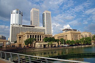
Colombo is the executive and judicial capital and largest city of Sri Lanka by population. According to the Brookings Institution, the Colombo metropolitan area has a population of 5.6 million, and 752,993 in the Municipality. It is the financial centre of the island and a tourist destination. It is located on the west coast of the island and adjacent to the Greater Colombo area which includes Sri Jayawardenepura Kotte, the legislative capital of Sri Lanka, and Dehiwala-Mount Lavinia. Colombo is often referred to as the capital since Sri Jayawardenepura Kotte is itself within the urban/suburban area of Colombo. It is also the administrative capital of the Western Province and the district capital of Colombo District. Colombo is a busy and vibrant city with a mixture of modern life, colonial buildings and monuments.

<span class="mw-page-title-main">Batticaloa</span> City in Sri Lanka

Batticaloa is a major city in the Eastern Province, Sri Lanka, and its former capital. It is the administrative capital of the Batticaloa District. The city is the seat of the Eastern University of Sri Lanka and is a major commercial centre. It is on the east coast, 111 kilometres (69 mi) south of Trincomalee, and is situated on an island. Pasikudah is a popular tourist destination situated 35 km (22 mi) northwest with beaches and flat year-round warm-water shallow-lagoons.

<span class="mw-page-title-main">Districts of Sri Lanka</span> Second-level administrative divisions of Sri Lanka

Districts are the second level administrative divisions of Sri Lanka, preceded by provinces. Sri Lanka has 25 districts organized into 9 provinces. Districts are further divided into a number of divisional secretariats, which are in turn subdivided into 14,022 grama niladhari divisions. There are 331 DS divisions in Sri Lanka.

<span class="mw-page-title-main">Ampara District</span> Administrative District in Eastern, Sri Lanka

Ampara District is one of the 25 districts of Sri Lanka, the second-level administrative divisions of the country. The district is administered by a District Secretariat headed by a District Secretary appointed by the central government of Sri Lanka. The capital of the district is the town of Ampara. The district was carved out of the southern part of Batticaloa District in April 1961.

<span class="mw-page-title-main">Sri Lankan Tamils</span> South Asian ethnic group

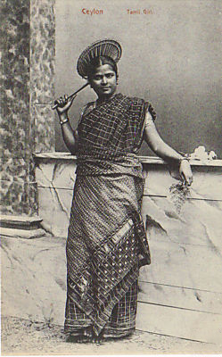
Sri Lankan Tamils, also known as Ceylon Tamils or Eelam Tamils, are Tamils native to the South Asian island state of Sri Lanka. Today, they constitute a majority in the Northern Province, form the plurality in the Eastern Province and are in the minority throughout the rest of the country. 70% of Sri Lankan Tamils in Sri Lanka live in the Northern and Eastern provinces.

<span class="mw-page-title-main">Sri Lanka Army</span> Land force branch of the Sri Lankan armed forces

The Sri Lanka Army is the oldest and largest of the Sri Lanka Armed Forces. Established as the Ceylon Army in 1949, it was renamed when Sri Lanka became a republic in 1972. In 2010, the Army had approximately 200,000 regular personnel, between 20,000 and 40,000 volunteer personnel and 18,000 National Guardsmen and comprises 13 divisions, one air-mobile brigade, one commando brigade, one special forces brigade, one independent armored brigade, three mechanized infantry brigades and over 40 infantry brigades.

<span class="mw-page-title-main">Jaffna District</span> Administrative District in Northern, Sri Lanka

Jaffna District is one of the 25 districts of Sri Lanka, the second level administrative division of the country. The district is administered by a District Secretariat headed by a District Secretary appointed by the central government of Sri Lanka. The capital of the district is the city of Jaffna.

Kankesanthurai, colloquially known as KKS, is a port suburb, fishing division and resort hub of the Jaffna District, Northern Province, Sri Lanka. Formerly an electoral district, Kankesanthurai is home to the Kankesanthurai beach, Keerimalai Naguleswaram temple and the Maviddapuram Kandaswamy Temple. The port's harbour has served as an arrival and departure point for pilgrims since classical antiquity and is named after the Sri Lankan Tamil god Murukan. Kankesanthurai suburb has many fishing villages and Grama Niladhari and is a northern part of Valikamam, one of the three regions of ancient habitation on the Jaffna peninsula, located on the peninsula's northern coast, 12 miles from Jaffna city, 85 miles from Mannar and 155 miles from Trincomalee.

<span class="mw-page-title-main">Kilinochchi District</span> Administrative District in Northern, Sri Lanka

Kilinochchi District is one of the 25 districts of Sri Lanka, the second level administrative division of the country. The district is administered by a District Secretariat headed by a District Secretary appointed by the central government of Sri Lanka. The capital of the district is the town of Kilinochchi.

<span class="mw-page-title-main">Batticaloa District</span> Administrative District in Eastern, Sri Lanka

Batticaloa District is one of the 25 districts of Sri Lanka, the second level administrative division of the country. The district is administered by a District Secretariat headed by a District Secretary appointed by the central government of Sri Lanka. The capital of the district is the city of Batticaloa. Ampara District was carved out of the southern part of Batticaloa District in April 1961.

<span class="mw-page-title-main">Mullaitivu District</span> Administrative District in Northern, Sri Lanka

Mullaitivu District is one of the 25 districts of Sri Lanka, the second level administrative division of the country. The district is administered by a District Secretariat headed by a District Secretary appointed by the central government of Sri Lanka. The capital of the district is the town of Mullaitivu.

<span class="mw-page-title-main">Trincomalee District</span> Administrative District in Eastern, Sri Lanka

Trincomalee District is one of the 25 districts of Sri Lanka, the second level administrative division of the country. The district is administered by a District Secretariat headed by a District Secretary appointed by the central government of Sri Lanka. The capital of the district is the city of Trincomalee.

<span class="mw-page-title-main">Vavuniya District</span> Administrative District in Northern, Sri Lanka

Vavuniya District is one of the 25 districts of Sri Lanka, the second level administrative division of the country. The district is administered by a District Secretariat headed by a District Secretary appointed by the central government of Sri Lanka. The capital of the district is the city of Vavuniya.

The 1978 Constitution of Sri Lanka provides for the election of members of Parliament from 22 multi-member electoral districts through the proportional representation electoral system.

Tharmapuram, or Dharmapuram, is a town in Kilinochchi District, Northern Province, Sri Lanka. It is about 13 km east to the town of Kilinochchi.

<span class="mw-page-title-main">Central Province, Sri Lanka</span> Province of Sri Lanka

The Central Province is one of the nine provinces of Sri Lanka. The province has an area of 5,674 km2 and a population of 2,421,148, making it the 2nd most populated province. The city of Kandy is the capital of the province.

<span class="mw-page-title-main">Administrative divisions of Sri Lanka</span>

Sri Lanka is divided into 9 provinces, which are further subdivided into 25 districts. Districts are further subdivided into Divisional Secretary's Divisions. Each DS Division is divided into Grama Niladhari Divisions.

<span class="mw-page-title-main">Northern Province, Sri Lanka</span> Province of Sri Lanka

The Northern Province is one of the nine provinces of Sri Lanka. The province has an area of 8,884 km2, making it the 3rd largest province by area, and a population of 1,061,315, making it the least populated province. The city of Jaffna is the capital city of the province.

<span class="mw-page-title-main">Mannar District</span> Administrative District in Northern, Sri Lanka

Mannar District is one of the 25 districts of Sri Lanka, the second level administrative division of the country. The district is administered by a District Secretariat headed by a District Secretary appointed by the central government of Sri Lanka. The capital of the district is Mannar, which is located on Mannar Island.

<span class="mw-page-title-main">Jaffna</span> City in Sri Lanka

Jaffna is the capital city of the Northern Province of Sri Lanka. It is the administrative headquarters of the Jaffna District located on a peninsula of the same name. With a population of 88,138 in 2012, Jaffna is Sri Lanka's 12th most populous city. Jaffna is approximately six miles from Kandarodai which served as an emporium in the Jaffna peninsula from classical antiquity. Jaffna's suburb Nallur served as the capital of the four-century-long medieval Tamil Jaffna Kingdom.

References

  1. Dutch heritage of Sri Lanka
  2. "Joshua Calder's World Island Info – Largest Islands of the World". Worldislandinfo.com. Retrieved 30 January 2016.
  3. "Table 05 (Geo., Topography) Islands in Sri Lanka". Sri Lanka Statistics.
  4. "Statistical Handbook 2009". Jaffna District Secretariat. Archived from the original on 26 March 2010.