
The Republic of Marshall Islands consists of 30 atolls (each made up of many islets) and 5 islands, which can be divided into two island chains, Ralik Chain and Ratak Chain.
The Republic of Marshall Islands consists of 30 atolls (each made up of many islets) and 5 islands, which can be divided into two island chains, Ralik Chain and Ratak Chain.
Administratively, the country is divided into 24 inhabited municipalities, corresponding to the 24 inhabited atolls or islands, where each of them is an electoral district.
| Municipality | Chain | Population (2021) [1] | Area (km2) | Area (mi2) |
|---|---|---|---|---|
| Ailinglaplap Atoll | Ralik | 1,175 | 15 | 6 |
| Ailuk Atoll | Ratak | 235 | 5 | 2 |
| Arno Atoll | Ratak | 1,141 | 13 | 5 |
| Aur Atoll | Ratak | 317 | 6 | 2 |
| Ebon Atoll | Ralik | 469 | 6 | 2 |
| Enewetok / Ujelang [upper-roman 1] | Ralik | 296 | 6 | 2 |
| Jabat Island | Ralik | 75 | 1 | 0 |
| Jaluit Atoll | Ralik | 1,409 | 11 | 4 |
| Kili / Bikini / Ejit [upper-roman 2] | Ralik | 415 | 1 | 0 |
| Kwajalein Atoll | Ralik | 9,789 | 16 | 6 |
| Lae Atoll | Ralik | 133 | 1 | 1 |
| Lib Island | Ralik | 156 | 1 | 0 |
| Likiep Atoll | Ratak | 288 | 10 | 4 |
| Majuro (capital) | Ratak | 23,156 | 10 | 4 |
| Maloelap Atoll | Ratak | 395 | 10 | 4 |
| Mejit Island | Ratak | 230 | 2 | 1 |
| Mili Atoll | Ratak | 497 | 16 | 6 |
| Namorik Atoll | Ralik | 299 | 3 | 1 |
| Namu Atoll | Ralik | 525 | 6 | 2 |
| Rongelap Atoll [upper-roman 3] | Ralik | 0 | 8 | 3 |
| Ujae Atoll | Ralik | 310 | 2 | 1 |
| Utirik Atoll | Ratak | 264 | 2 | 1 |
| Wotho Atoll | Ralik | 88 | 4 | 2 |
| Wotje Atoll | Ratak | 816 | 8 | 3 |
The remaining 11 atolls/islands are currently uninhabited. According to the Constitution of the Republic of the Marshall Islands, the uninhabited atolls/islands Narikrik, Erikub, Jemo, Taka, Bikar, Bokak, Rongrik and Ailinginae shall each be included in the electoral district with which it is most closely associated, pursuant to the customary law or any traditional practice. [2] Ujelang is listed with the Enewetak & Ujelang District, and Bikini with the Bikini & Kili District.
| Atoll/Island | Chain | Area (km2) | Area (mi2) |
|---|---|---|---|
| Ailinginae Atoll [lower-roman 1] | Ralik | 3 | 1 |
| Bikar Atoll | Ratak | 0.69 | 0.27 |
| Bikini Atoll | Ralik | 6 | 2 |
| Bokak Atoll | Ratak | 3 | 1 |
| Erikub Atoll [lower-roman 2] | Ratak | 2 | 1 |
| Jemo Island [lower-roman 3] | Ratak | 0.21 | 0.08 |
| Nadikdik Atoll | Ratak | 1 | 0 |
| Rongerik Atoll [lower-roman 1] | Ralik | 2 | 1 |
| Toke Atoll [lower-roman 4] | Ratak | 0.57 | 0.22 |
| Ujelang Atoll | Ralik | 2 | 1 |
| Wake Atoll [lower-roman 5] | Ratak | 7 | 3 |

The Marshall Islands, officially the Republic of the Marshall Islands, is an island country west of the International Date Line and north of the equator in the Micronesia region in the Northwestern Pacific Ocean. The territory consists of 29 coral atolls and five islands, divided across two island chains: Ratak in the east and Ralik in the west. 97.87% of its territory is water, the largest proportion of water to land of any sovereign state. The country shares maritime boundaries with Wake Island to the north, Kiribati to the southeast, Nauru to the south, and the Federated States of Micronesia to the west. The capital and largest city is Majuro, home to approximately half of the country's population.

Micronesia is a subregion of Oceania, consisting of about 2,000 small islands in the Northwestern Pacific Ocean. It has a close shared cultural history with three other island regions: Maritime Southeast Asia to the west, Polynesia to the east, and Melanesia to the south—as well as with the wider community of Austronesian peoples.
Austronesian settlers arrived in the Marshall Islands in the 2nd millennium BC, but there are no historical or oral records of that period. Over time, the Marshallese people learned to navigate over long ocean distances by walap canoe using traditional stick charts.
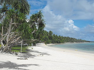
Majuro is the capital and largest city of the Marshall Islands. It is also a large coral atoll of 64 islands in the Pacific Ocean. It forms a legislative district of the Ratak (Sunrise) Chain of the Marshall Islands. The atoll has a land area of 9.7 square kilometers (3.7 sq mi) and encloses a lagoon of 295 square kilometers (114 sq mi). As with other atolls in the Marshall Islands, Majuro consists of narrow land masses. It has a tropical trade wind climate, with an average temperature of 27 °C (81 °F).

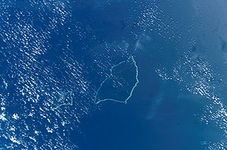
Bikini Atoll, known as Eschscholtz Atoll between the 1800s and 1946, is a coral reef in the Marshall Islands consisting of 23 islands surrounding a 229.4-square-mile (594.1 km2) central lagoon. The Atoll is at the northern end of the Ralik Chain, approximately 530 miles (850 km) northwest of the capital Majuro.

The Ralik Chain is a chain of islands within the island nation of the Marshall Islands. Ralik means "sunset". It is west of the Ratak Chain. In 1999 the total population of the Ralik islands was 19,915. Christopher Loeak, who became President of the Marshall Islands in 2012, was formerly Minister for the Ralik Chain.
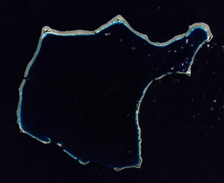
The Maloelap Atoll is a coral atoll of 71 islands in the Pacific Ocean, and forms a legislative district of the Ratak Chain of the Marshall Islands. Its land area is only 9.8 square kilometers (3.8 sq mi), but that encloses a lagoon of 972 square kilometers (375 sq mi). It is located 18 kilometers (11 mi) north of the atoll of Aur. The population of the atoll was 395 at the 2021 census.
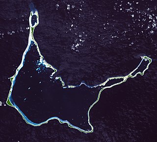
Arno Atoll is a coral atoll of 133 islands in the Pacific Ocean, and forms a legislative district of the Ratak Chain of the Marshall Islands. Its total land area is only 5 square miles (13 km2). Unlike most other atolls, Arno encloses three different lagoons, a large central one, and two smaller ones in the north and east. Its main lagoon encloses an area of 130.77 square miles (338.7 km2). At a distance of only 20 kilometers (12 mi), it is the closest atoll to the Marshall Islands capital, Majuro Atoll, and can be seen looking east from Majuro on a clear day at low tide. The population of Arno Atoll was 1,141 at the 2021 census. The most populous islets are Ajeltokrok, Kobjeltak, Rearlaplap, Langor and Tutu. The largest village is Ine, Arno.
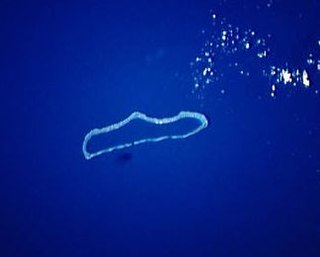
Rongelap AtollRONG-gə-lap is an uninhabited coral atoll of 61 islands in the Pacific Ocean, and forms a legislative district of the Ralik Chain of the Marshall Islands. Its total land area is 8 square miles (21 km2). It encloses a lagoon with an area of 1,000 square miles (2,600 km2). It is historically notable for its close proximity to US hydrogen bomb tests in 1954, and was particularly devastated by fallout from the Castle Bravo test. The population asked the US to move them from Rongelap following the test due to high radiation levels with no success so they asked global environmental group Greenpeace to help. The Rainbow Warrior made four trips moving the islanders, their possessions and their homes to the island of Mejato in the Kwajalein Atoll, 180 kilometers away.

Rongerik Atoll or Rongdrik Atoll is an unpopulated coral atoll of 17 islands in the Pacific Ocean, and is located in the Ralik Chain of the Marshall Islands, approximately 200 kilometers (120 mi) east of Bikini Atoll. Its total land area is only 1.68 square kilometers (0.65 sq mi), but it encloses a lagoon of 144 square kilometers (56 sq mi).

Kili Island or Kili Atoll is a small, 81 hectares island located in the Marshall Islands in the Pacific Ocean. As of 2021, 415 people lived on the island, many of whom were descended from islanders who originally lived on Bikini Atoll. They were relocated when they agreed to let the U.S. government temporarily use their home for nuclear testing in 1945. Kili Island became their home after two prior relocations failed. The island does not have a natural lagoon and cannot produce enough food to enable the islanders to be self-sufficient. It is part of the legislative district of the Ralik Chain of the Marshall Islands. The island is approximately 48 kilometers (30 mi) southwest of Jaluit. It is one of the smallest islands in the Marshall Islands.

Ujae Atoll is a coral atoll of 15 islands in the Pacific Ocean, and forms a legislative district of the Ralik Chain of the Marshall Islands. Its total land area is only 1.86 square kilometers (0.72 sq mi), but it encloses a lagoon of 185.94 square kilometers (71.79 sq mi). It is located about 122 kilometers (76 mi) west of Kwajalein Atoll.

Utirik Atoll or Utrik Atoll is a coral atoll of 10 islands in the Pacific Ocean, and forms a legislative district of the Ratak Chain of the Marshall Islands. Its total land area is only 2.4 square kilometers (0.94 sq mi), but it encloses a lagoon with an area of 57.7 square kilometers (22.29 sq mi). It is located approximately 47 kilometers (29 mi) east of Ujae Atoll. The population of Utirik Atoll was 264 at the 2021 census. It is one of the northernmost Marshall Islands with permanent habitation.
Ujelang Atoll is an uninhabited coral atoll of 30 islands in the Pacific Ocean, in the Ralik Chain of the Marshall Islands. Its total land area is 1.86 square kilometers (0.72 sq mi), and it encloses a lagoon of 185.94 square kilometers (71.79 sq mi). It is the westernmost island in the Marshall Islands, approximately 217 kilometers (135 mi) southeast of Enewetak, and approximately 600 kilometers (370 mi) west of the main Ralik Chain.
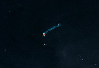
Jemo Island Atoll is an uninhabited coral island in the Pacific Ocean, in the Ratak Chain of the Marshall Islands north-east of Likiep Atoll. The island is oval-shaped and occupies the southwestern end of a narrow submarine ridge that extends to the northeast for several kilometers. Its total land area is only 0.16 square kilometers (0.062 sq mi). The island is traditionally held as a food reserve for the family of Joachim and Lijon deBrum, passed down to Lijon debrum from Iroijlaplap Lobareo and is owned by the current Likiep land-owning families of Joachim and Lijon debrum, grandkids of Iroijlaplap Jortõka of Ratak Eañ. There is also a shipwreck of unknown origin on the west side of the island.

Erikub Atoll is an uninhabited coral atoll of fourteen islands in the Pacific Ocean, located in the Ratak Chain of the Marshall Islands. Its total land area is only 1.53 square kilometers (0.59 sq mi), but it encloses a lagoon with an area of 230 square kilometers (89 sq mi). It is located slightly south of Wotje.
The government of the Marshall Islands operates under a mixed parliamentary-presidential system as set forth in its Constitution. Elections are held every four years in universal suffrage, with each of the 24 constituencies electing one or more representatives (senators) to the lower house of RMI's unicameral legislature, the Nitijela. The President, who is head of state as well as head of government, is elected by the 33 senators of the Nitijela. Four of the five Marshallese presidents who have been elected since the Constitution was adopted in 1979 have been traditional paramount chiefs.
ISO 3166-2:MH is the entry for the Marshall Islands in ISO 3166-2, part of the ISO 3166 standard published by the International Organization for Standardization (ISO), which defines codes for the names of the principal subdivisions of all countries coded in ISO 3166-1.

The following is an alphabetical list of topics related to the Marshall Islands.
The Baháʼí Faith in the Marshall Islands begins after 1916 with a mention by ʻAbdu'l-Bahá, then head of the religion, that Baháʼís should take the religion there. The first Baháʼí to pioneer there arrived in August 1954 however she could only stay until March 1955. Nevertheless, with successive pioneers and converts the first Baháʼí Local Spiritual Assembly in 1967 in Majuro. The community continued to grow and in 1977 elected its first National Spiritual Assembly. Before 1992 the Baháʼís began to operate state schools under contract with the government. Middle estimates of the Baháʼí population are just over 1,000, or 1.50% in 2000.
Marshall Islands articles | |||||||
|---|---|---|---|---|---|---|---|
| History | |||||||
| Geography |
| ||||||
| Politics |
| ||||||
| Economy | |||||||
| Culture |
| ||||||
| |||||||
Articles on first-level administrative divisions of Oceanian countries | |
|---|---|
| | |
| | |
| | |
| | |
| Authority control databases: National |
|---|