| Lighthouse | Image | Location & coordinates | County | Year built | Tower height | Focal height | Range | Operator | NGA number |
|---|
| Anvil Point Lighthouse |  | Anvil Point
50°35′31″N 1°57′36″W | Dorset | 1881 | 12 m (39 ft) | 45 m (148 ft) | 9 nmi (17 km; 10 mi) | Trinity House | 114-0544 |
|---|
| Bamburgh Lighthouse |  | Bamburgh
55°37′0″N 1°43′27″W | Northumberland | 1910 [10] | 9 m (30 ft) [10] | 12 m (39 ft) [11] | 14 nmi (26 km; 16 mi) [11] (white), 11 nmi (20 km; 13 mi) [11] (red green) | Trinity House [10] | 114-2252 |
|---|
| Beachy Head Lighthouse |  | Beachy Head
50°44′2″N 0°14′29″E [12] | Sussex | 1902 | 33 m (108 ft) | 31 m (102 ft) [13] | 8 nmi (15 km; 9.2 mi) [13] | Trinity House | 114-1140 [13] |
|---|
| Berkeley Pill Front light |  | Severn Estuary
51°41′59″N 2°29′24″W | Gloucestershire | 1937 | 8 m (26 ft) | 5 m (16 ft) | | Gloucester Harbour Trustees | |
|---|
| Berkeley Pill Rear light |  | Severn Estuary
51°41′54″N 2°29′25″W | Gloucestershire | 1937 | 12 m (39 ft) | 11 m (36 ft) | | Gloucester Harbour Trustees | |
|---|
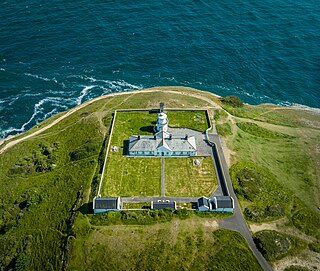
| Berry Head Lighthouse | 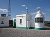 | Berry Head
50°23′58″N 3°29′0″W | Devon | 1906 | 5 m (16 ft) | 58 m (190 ft) [11] | 19 nmi (35 km; 22 mi) [11] | Trinity House | 114-0344 |
|---|
| Berwick Lighthouse |  | Berwick-upon-Tweed
55°45′53″N 1°59′7″W | Northumberland | 1826 | 13 m (43 ft) | 15 m (49 ft) [13] | 6 nmi (11 km; 6.9 mi) [13] | Port of Berwick | 114-2264 [13] |
|---|
| Bishop Rock Lighthouse |  | Bishop Rock
49°52′18″N 6°26′42″W | Cornwall | 1858 [14] | 49 m (161 ft) [14] | 44 m (144 ft) [14] | 20 nmi (37 km; 23 mi) [14] | Trinity House [14] | 114-4 |
|---|
| Bull Point Lighthouse |  | Mortehoe
51°11′57″N 4°12′4″W | Devon | 1879 | 11 m (36 ft) | 54 m (177 ft) [11] | 20 nmi (37 km; 23 mi) [11] | Trinity House | 114-6228 |
|---|
| Burnham-on-Sea Low Lighthouse |  | Burnham-on-Sea
51°14′54″N 3°0′21″W [15] | Somerset | 1832 [lower-alpha 1] | 9 m (30 ft) | | | Somerset Council [lower-alpha 2] | 114-6172 |
|---|
| Chapel Rock Lighthouse |  | Gloucestershire
51°36′26″N 2°39′12″W | Gloucestershire | 1907 | 8 m (26 ft) | 6 m (20 ft) | 8 nmi (15 km; 9.2 mi) | Gloucester Harbour Trustees | 114-5994 |
|---|
| Coquet Lighthouse | 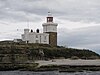 | Hauxley
55°20′2″N 1°32′23″W [16] | Northumberland | 1841 [17] | 22 m (72 ft) [17] | 25 m (82 ft) [11] | 19 nmi (35 km; 22 mi) [11] (white), 15 nmi (28 km; 17 mi) [11] (red) | Trinity House [17] | 114-2228 |
|---|
| Cromer Lighthouse |  | Cromer [18]
52°55′29″N 1°19′0″E [18] | Norfolk | 1833 [19] | 18 m (59 ft) [19] | 84 m (276 ft) [11] [19] | 21 nmi (39 km; 24 mi) [11] [19] | Trinity House [19] | 114-1676 |
|---|
| Crow Point Lighthouse |  | Braunton Burrows
51°3′58″N 4°11′23″W | Devon | 1954 | 5 m (16 ft) | 7.6 m (25 ft) | 6 nmi (11 km; 6.9 mi) [11] (white), 5 nmi (9.3 km; 5.8 mi) [11] (red) | Trinity House | 114-6240 |
|---|
| Dungeness Lighthouse | 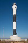 | Dungeness
50°54′49″N 0°58′33″E [20] | Kent | 1961 | 43 m (141 ft) | 40 m (130 ft) [11] | 21 nmi (39 km; 24 mi) [11] | Trinity House | 114-1220 |
|---|
| Eddystone Lighthouse | 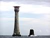 | Eddystone Rocks
50°10′48″N 4°15′54″W | Cornwall | 1882 [21] | 49 m (161 ft) [21] | 41 m (135 ft), [11] [21] [13] 28 m (92 ft) [13] | 17 nmi (31 km; 20 mi) [11] [21] [13] (white), 8 nmi (15 km; 9.2 mi) [13] (red) | Trinity House [21] | 114-132 [13] |
|---|
| Farne Lighthouse |  | Farne Islands
55°36′55″N 1°39′21″W [22] | Northumberland | 1811 [23] | 13 m (43 ft) [23] | 27 m (89 ft) [13] [23] | 10 nmi (19 km; 12 mi) [13] (white), 7 nmi (13 km; 8.1 mi) [13] (red) | Trinity House [23] | 114-2256 [13] |
|---|
| Flamborough Head Lighthouse |  | Flamborough [24]
54°6′59″N 0°4′57″W [24] | Yorkshire | 1806 [24] | 26.5 m (87 ft) | 65 m (213 ft) [11] | 24 nmi (44 km; 28 mi) [11] | Trinity House, East Riding of Yorkshire Council | 114-1964 [13] |
|---|
| Pharos Lighthouse |  | Fleetwood [25]
53°55′35″N 3°0′27″W [25] | Lancashire | 1840 | 27 m (89 ft) | 28 m (92 ft) | 9 nmi (17 km; 10 mi) | Port of Fleetwood | 114-5156 |
|---|
| Beach Lighthouse |  | Fleetwood [26]
53°55′43″N 3°0′33″W [26] | Lancashire | 1840 | 13 m (43 ft) | 14 m (46 ft) [13] | 9 nmi (17 km; 10 mi) [13] | Port of Fleetwood | 114-5152 |
|---|
| Folkestone Lighthouse |  | Folkestone [27]
51°4′34″N 1°11′41″E [27] | Kent | 1860 | 13 m (43 ft) | 14 m (46 ft) | 22 nmi (41 km; 25 mi) | Folkestone Harbour | 114-1228 |
|---|
| Godrevy Lighthouse | 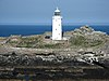 | St Ives
50°14′33″N 5°24′1″W [28] | Cornwall | 1 Mar 1859 | 26 m (85 ft) | 28 m (92 ft) [11] | 8 nmi (15 km; 9.2 mi) [11] | Trinity House | 114-6284 |
|---|
| Gorleston South Pier Lighthouse |  | Gorleston-on-Sea
52°34′20″N 1°44′17″E | Norfolk | 1955 | 8 m (26 ft) | 11 m (36 ft) | 11 nmi (20 km; 13 mi) | Great Yarmouth Port Authority | 114-1624 |
|---|
| Guile Point East Lighthouse |  | Lindisfarne
55°39′30″N 1°47′35″W | Northumberland | 1859 [29] | 29 ft (8.8 m) [13] | 9 m (30 ft) [29] [13] | 4 nmi (7.4 km; 4.6 mi) [29] [13] | Trinity House [29] (from Nov 1995), Newcastle-upon-Tyne Trinity House (until Nov 1995) [lower-alpha 3] | 114-2262 [13] |
|---|
| Happisburgh Lighthouse |  | Happisburgh
52°49′10″N 1°32′19″E | Norfolk | 1791 | 26 m (85 ft) | 41 m (135 ft) [13] | 14 nmi (26 km; 16 mi) [13] | Trinity House (until 1990), Happisburgh Lighthouse Trust (from 1990) | 114-1668 |
|---|
| Hartland Point Lighthouse |  | Hartland Point
51°1′20″N 4°31′32″W [30] | Devon | 1874 | 18 m (59 ft) | 37 m (121 ft) | 8 nmi (15 km; 9.2 mi) | Trinity House [lower-alpha 4] | 114-6252 |
|---|
| Heugh Lighthouse |  | Hartlepool
54°41′47″N 1°10′34″W | County Durham | 1927 | 16 m (52 ft) | 19 m (62 ft) [11] | 19 nmi (35 km; 22 mi) [11] | PD Ports | 114-2056 |
|---|
| Herd Groyne Light |  | South Shields
55°0′29″N 1°25′27″W | County Durham | 1882 | 15 m (49 ft) | 13 m (43 ft) [13] | 19 nmi (35 km; 22 mi) [13] (white), 11 nmi (20 km; 13 mi) [13] (green red) | Port of Tyne | 114-2112 |
|---|
| Heugh Hill Lighthouse |  | Lindisfarne
55°40′6″N 1°47′59″W | Northumberland | 1826 [31] | 8 m (26 ft) | 24 m (79 ft) [31] | 5 nmi (9.3 km; 5.8 mi) [31] | Trinity House [31] [lower-alpha 3] | 114-2263 |
|---|
| Hilbre Island Lighthouse |  | Hilbre Island
53°23′0″N 3°13′43″W | Merseyside | 1927 [32] | 3 m (9.8 ft) [32] | 14 m (46 ft) [32] [13] | 5 nmi (9.3 km; 5.8 mi) [32] [13] | Trinity House [32] [lower-alpha 5] | 114-5380 [13] |
|---|
| Hurst Point Lighthouse |  | Hurst Castle
50°42′29″N 1°33′1″W | Hampshire | 1867 | 26 m (85 ft) | 23 m (75 ft), [11] 19 m (62 ft) [11] | 13 nmi (24 km) | Trinity House | 114-0596 |
|---|
| Ilfracombe Lighthouse |  | Ilfracombe
51°12′40″N 4°6′47″W | Devon | 1819 | 11 m (36 ft) | 39 m (128 ft) [13] | 6 nmi (11 km; 6.9 mi) [13] | Ilfracombe Harbour Board | 114-6220 |
|---|
| Instow Front Lighthouse |  | Instow
51°3′37″N 4°10′40″W | Devon | 1820 | 18 m (59 ft) | 22 m (72 ft) [33] [11] | 15 nmi (28 km; 17 mi) [33] [11] | Trinity House | |
|---|
| Instow Rear Lighthouse |  | Instow
51°3′31″N 4°10′21″W | Devon | 1820 | 8.5 m (28 ft) | 38 m (125 ft) [34] [11] | 15 nmi (28 km; 17 mi) [34] [11] | Trinity House | 114-6236 |
|---|
| Killingholme High Lighthouse |  | South Killingholme
53°38′50″N 0°13′8″W [35] | Lincolnshire | 1876 | 24 m (79 ft) | 22 m (72 ft) | 3 nmi (5.6 km; 3.5 mi) | Port of Immingham [lower-alpha 6] | 114-1916 |
|---|
| Killingholme South Low Lighthouse |  | South Killingholme
53°38′48″N 0°12′58″W [36] | Lincolnshire | 1836 | 14 m (46 ft) | 10 m (33 ft) [13] | 14 nmi (26 km; 16 mi) [13] | Port of Immingham [lower-alpha 6] | 114-1912 |
|---|
| Lizard Lighthouse |  | Lizard Point
49°57′37″N 5°12′7″W | Cornwall | 1751 | 19 m (62 ft) | 70 m (230 ft) [11] | 26 nmi (48 km; 30 mi) [11] | Trinity House | 114-0064 |
|---|
| Longships Lighthouse |  | Longships
50°4′1″N 5°44′48″W | Cornwall | 1875 | 35 m (115 ft) | 35 m (115 ft) [11] | 15 nmi (28 km; 17 mi) [11] (white), 11 nmi (20 km; 13 mi) [11] (red) | Trinity House | 114-0024 |
|---|
| Longstone Lighthouse |  | Farne Islands
55°38′38″N 1°36′39″W [37] | Northumberland | 1826 [38] | 26 m (85 ft) [38] | 23 m (75 ft) [11] [38] [13] | 24 nmi (44 km; 28 mi), [11] [13] 18 nmi (33 km; 21 mi) [38] | Trinity House [38] | 114-2260 [13] |
|---|
| Lowestoft Lighthouse |  | Lowestoft
52°29′12″N 1°45′30″E | Suffolk | 1874 [39] | 16 m (52 ft) [39] | 37 m (121 ft) [11] [39] | 23 nmi (43 km; 26 mi) [11] [39] | Trinity House [39] | 114-1620 |
|---|
| Lundy North Lighthouse | 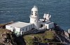 | Torridge, [40] Lundy
51°12′6″N 4°40′38″W [40] | Devon | 1897 [41] | 17 m (56 ft) [41] | 48 m (157 ft) [11] [41] | 17 nmi (31 km; 20 mi) [11] | Trinity House [41] | 114-6244 |
|---|
| Lundy South Lighthouse |  | Torridge, [42] Lundy
51°9′43″N 4°39′21″W [42] | Devon | 1897 [43] | 16 m (52 ft) [43] | 53 m (174 ft) [11] [43] | 15 nmi (28 km; 17 mi) [11] [43] | Trinity House [43] | 114-6248 |
|---|
| Lyde Rock lighthouse |  | Severn Estuary
51°36′53″N 2°38′40″W | Gloucestershire | 2008 | 10 m (33 ft) | 12 m (39 ft) | 5 nmi (9.3 km; 5.8 mi) | Gloucester Harbour Trustees | |
|---|
| Lynmouth Foreland Lighthouse |  | Foreland Point
51°14′43″N 3°47′12″W [44] | Devon | 1900 | 15 m (49 ft) | 67 m (220 ft) [11] | 18 nmi (33 km; 21 mi) [11] | Trinity House | 114-6208 |
|---|
| Maryport New Lighthouse |  | Maryport
54°43′4″N 3°30′38″W | Cumberland | 1996 | 4.7 m (15 ft), 6 m (20 ft) | 10 m (33 ft) | 6 nmi (11 km; 6.9 mi) | Trinity House (until 2010), Maryport Harbour Authority (from 2010) | 114-4860 |
|---|
| Nab Tower |  | Nab Rock
50°40′3″N 0°57′4″W | - | 1918 [45] | 27 m (89 ft) | 17 m (56 ft) [45] | 12 nmi (22 km; 14 mi) [45] | Trinity House [45] | 114-1048 |
|---|
| Needles Lighthouse |  | Alum Bay
50°39′44″N 1°35′30″W | Isle of Wight | 1859 | 31 m (102 ft) | 24 m (79 ft) | 17 nmi (31 km; 20 mi) | Trinity House | 114-0584 |
|---|
| North Foreland Lighthouse |  | North Foreland
51°22′30″N 1°26′42″E [46] | Kent | 1691 [47] | 26 m (85 ft) [47] | 57 m (187 ft) [11] [47] | 19 nmi (35 km) | Trinity House [47] | 114-1364 |
|---|
| Pendeen Lighthouse |  | Pendeen
50°9′54″N 5°40′18″W | Cornwall | 1900 | 17 m (56 ft) | 59 m (194 ft) [11] | 16 nmi (30 km; 18 mi) [11] | Trinity House | 114-6304 |
|---|
| Peninnis Lighthouse |  | Peninnis Head
49°54′17″N 6°18′13″W | Cornwall | 1911 [48] | 14 m (46 ft) [48] | 36 m (118 ft) [48] | 9 nmi (17 km; 10 mi) [48] | Trinity House [48] | 114-8 |
|---|
| Plover Scar Lighthouse |  | Cockersand Abbey
53°58′53″N 2°52′57″W | Lancashire | 1847 | 8 m (26 ft) | 6 m (20 ft) | 6 nmi (11 km; 6.9 mi) | Lancaster Port Commission | 114-5144 |
|---|
| Plymouth Breakwater Lighthouse |  | Plymouth Breakwater
50°20′4″N 4°9′32″W | Devon | 1844 [49] | 23 m (75 ft) | 19 m (62 ft) [13] | 12 nmi (22 km; 14 mi) [13] (white), 9 nmi (17 km; 10 mi) [13] (red) | Ministry of Defence (from 1993), Trinity House (until 1993) | 114-148 |
|---|
| Portishead Point Lighthouse |  | Portishead
51°29′38″N 2°46′19″W | Somerset | 1931 | 9 m (30 ft) | 9 m (30 ft) [11] | 16 nmi (30 km; 18 mi) [11] | Port of Bristol | 114-6144 |
|---|
| Portland Bill Lighthouse |  | Portland Bill
50°30′51″N 2°27′23″W [50] | Dorset | 1903 | 41 m (135 ft) | 43 m (141 ft) [11] | 25 nmi (46 km; 29 mi) [11] | Trinity House | 114-0448 |
|---|
| Portland Breakwater Lighthouse |  | Isle of Portland
50°35′9″N 2°25′4″W | Dorset | 1905 | 22 m (72 ft) | 22 m (72 ft) | 10 nmi (19 km; 12 mi) | Portland Harbour Authority | 114-0464 |
|---|
| Rampside Lighthouse |  | Rampside
54°5′11″N 3°9′40″W [51] | Lancashire | 1875 | 16 m (52 ft) | 14 m (46 ft) | 14 nmi (26 km; 16 mi) | Port of Barrow | 114-5076 |
|---|
| Ramsgate West Pier Lighthouse |  | Ramsgate [52]
51°19′40″N 1°25′17″E [52] | Kent | 1842 | 11 m (36 ft) | 12 m (39 ft) | 7 nmi (13 km; 8.1 mi) | Port of Ramsgate | 114-1348 |
|---|
| Roker Pier lighthouse |  | Roker
54°55′17″N 1°21′9″W | County Durham | 1903 | 23 m (75 ft) | 25 m (82 ft) | 23 nmi (43 km; 26 mi) | Port of Sunderland | 114-2084 |
|---|
| Round Island Lighthouse |  | Tresco [53]
49°58′44″N 6°19′23″W [53] | Cornwall | 1887 | 19 m (62 ft) | 55 m (180 ft) [11] | 18 nmi (33 km; 21 mi) [11] | Trinity House | 114-16 |
|---|
| Royal Sovereign Lighthouse |  | Eastbourne
50°43′24″N 0°26′8″E | Sussex | 1971 [54] | 36 m (118 ft) [54] | 28 m (92 ft) [13] | 12 nmi (22 km; 14 mi) [13] | Trinity House [54] | 114-1144 |
|---|
| St Anthony's Lighthouse |  | St Anthony Head
50°8′28″N 5°0′57″W [55] | Cornwall | 1835 [56] | 19 m (62 ft) [57] | 22 m (72 ft) [11] [57] | 16 nmi (30 km; 18 mi) [11] (white), 14 nmi (26 km; 16 mi) [11] (red) | Trinity House [57] | 114-68 [13] |
|---|
| St Bees Lighthouse |  | St Bees Head
54°30′49″N 3°38′11″W | Cumberland | 1822 [58] | 17 m (56 ft) | 102 m (335 ft) [11] [13] | 18 nmi (33 km; 21 mi) [11] [13] | Trinity House [58] | 114-4892 [13] |
|---|
| St. Catherine's Lighthouse |  | St. Catherine's Point
50°34′33″N 1°17′52″W | Isle of Wight | 1838 [59] | 27 m (89 ft) | 41 m (135 ft) [11] | 25 nmi (46 km; 29 mi) [11] | Trinity House | 114-1064 |
|---|
| Scarborough Lighthouse |  | Scarborough [60]
54°16′55″N 0°23′24″W [60] | Yorkshire | 1931 | 15 m (49 ft) | 17 m (56 ft) | 9 nmi (17 km; 10 mi) | Scarborough Borough Council | 114-1976 |
|---|
| Shoreham Lighthouse |  | Kingston by Sea
50°49′51″N 0°14′54″W [61] | Sussex | 1846 | 12 m (39 ft) | 13 m (43 ft) | 10 nmi (19 km; 12 mi) | Shoreham Port Authority | 114-1116 |
|---|
| South Gare Lighthouse |  | South Gare
54°38′51″N 1°8′15″W | Yorkshire | 1884 | 13 m (43 ft) | 16 m (52 ft) | 20 nmi (37 km; 23 mi) (white), 17 nmi (31 km; 20 mi) (red) | PD Ports [62] | 114-2020 |
|---|
| Southwold Lighthouse |  | Southwold [63]
52°19′38″N 1°40′53″E [63] | Suffolk | 1887 [64] | 31 m (102 ft) [64] | 37 m (121 ft) [11] [64] | 24 nmi (44 km; 28 mi) [11] [64] | Trinity House [64] | 114-1588 |
|---|
| Start Point Lighthouse |  | Start Point
50°13′21″N 3°38′32″W [65] | Devon | 1836 | 28 m (92 ft) | 62 m (203 ft), [11] 55 m (180 ft) [11] | 25 nmi (46 km; 29 mi) [11] (white), 9 nmi (17 km; 10 mi) [11] (red) | Trinity House | 114-0324 |
|---|
| Tater Du Lighthouse |  | Tregurnow
50°3′7″N 5°34′36″W | Cornwall | 1965 | 15 m (49 ft) | 34 m (112 ft) [11] [13] | 20 nmi (37 km; 23 mi) [11] | Trinity House | 114-0032 |
|---|
| Teignmouth Lighthouse |  | Teignmouth [66]
50°32′33″N 3°29′49″W [66] | Devon | 1845 | 6 m (20 ft) | 10 m (33 ft) [13] | 6 nmi (11 km; 6.9 mi) [13] | Teignmouth Harbour Commission | 114-392 [13] |
|---|
| Thorngumbald Clough High Lighthouse |  | Paull [67]
53°42′29″N 0°13′32″W [67] | Yorkshire | 1870 | 15 m (49 ft) | 13 m (43 ft) [13] | 9 nmi (17 km; 10 mi) [13] | Port of Hull [lower-alpha 6] | 114-1932 |
|---|
| Thorngumbald Clough Low Lighthouse |  | Paull [68]
53°42′32″N 0°13′37″W [68] | Yorkshire | 1870 | 9 m (30 ft) | 8 m (26 ft) [13] | 9 nmi (17 km; 10 mi) [13] | Port of Hull [lower-alpha 6] | 114-1928 |
|---|
| Trevose Head Lighthouse |  | Trevose Head
50°32′57″N 5°2′7″W [69] | Cornwall | 1847 [70] | 27 m (89 ft) [70] | 62 m (203 ft) [11] [70] | 21 nmi (39 km; 24 mi) [11] [70] | Trinity House [70] | 114-6272 [13] |
|---|
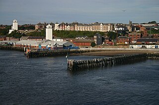
| Tynemouth North Pier light |  | Tynemouth
55°0′52″N 1°24′11″W | Northumberland | 1903 | 23 m (75 ft) | 26 m (85 ft) [13] | 26 nmi (48 km; 30 mi) [13] | Port of Tyne | 114-2104 |
|---|
| Tyne South Pier light |  | South Shields
55°0′40″N 1°24′4″W | County Durham | 1895 | 12 m (39 ft) | 15 m (49 ft) | 13 nmi (24 km; 15 mi) | Port of Tyne | 114-2108 |
|---|
| Walney Lighthouse |  | Walney Island
54°2′55″N 3°10′38″W | Lancashire | 1804 | 24 m (79 ft) | 21 m (69 ft) [11] | 23 nmi (43 km; 26 mi) [11] | Lancaster Port Commission | 114-5052 |
|---|
| Watchet Harbour Lighthouse |  | Watchet
51°10′59″N 3°19′44″W | Somerset | 1862 | 7 m (23 ft) | 9 m (30 ft) | 9 nmi (17 km; 10 mi) | Watchet Marina | 114-6196 |
|---|
| Whitby Lighthouse |  | Whitby
54°28′40″N 0°34′6″W | Yorkshire | 1858 [71] | 13 m (43 ft) [71] | 73 m (240 ft) [11] | 18 nmi (33 km; 21 mi) [11] [71] | Trinity House [71] | 114-1992 [13] |
|---|
| Whitby East Pier beacon |  | Whitby
54°29′39″N 0°36′44″W [72] | Yorkshire | 1914 | 7 m (23 ft) | 12 m (39 ft) [13] | 5 nmi (9.3 km; 5.8 mi) [13] | Scarborough Borough Council | 114-1988 |
|---|
| Whitby West Pier beacon |  | Whitby
54°29′39″N 0°36′48″W [72] | Yorkshire | 1914 | 7 m (23 ft) | 12 m (39 ft) [13] | 5 nmi (9.3 km; 5.8 mi) [13] | Scarborough Borough Council | 114-1984 |
|---|
| Whitby East Pier Lighthouse |  | Whitby, [73] North Yorkshire
54°29′34″N 0°36′43″W [73] | Yorkshire | 1855 | 17 m (56 ft) | | | Whitby Harbour Board | |
|---|
| Whitby West Pier Lighthouse |  | Whitby [74]
54°29′34″N 0°36′46″W [74] | Yorkshire | 1831 | 25 m (82 ft) | | | Whitby Harbour Board | |
|---|
| West Pier Lighthouse |  | Whitehaven
54°33′10″N 3°35′55″W [75] | Cumberland | 1839 | 14 m (46 ft) | 16 m (52 ft) [13] | 6 nmi (11 km; 6.9 mi) [13] | Whitehaven Harbour Commissioners | 114-4880 |
|---|
| Whitgift Lighthouse |  | Whitgift
53°41′56″N 0°45′27″W [76] | Yorkshire | | 14 m (46 ft) | 12 m (39 ft) | | Associated British Ports | |
|---|
| Wolf Rock Lighthouse |  | Wolf Rock
49°56′43″N 5°48′30″W | Cornwall | 1869 [77] | 41 m (135 ft) [77] | 34 m (112 ft) [13] [77] | 16 nmi (30 km; 18 mi) [13] [77] | Trinity House [77] | 114-28 |
|---|