Related Research Articles

Malawi is a landlocked country in southeast Africa. It is wholly within the tropics; from about 9°30S at its northernmost point to about 17°S at the southernmost tip. The country occupies a thin strip of land between Zambia and Mozambique, extending southwards into Mozambique along the valley of the Shire River. In the north and north east it also shares a border with Tanzania. Malawi is connected by rail to the Mozambican ports of Nacala and Beira. It lies between latitudes 9° and 18°S, and longitudes 32° and 36°E.

Mangochi is a township in the Southern Region of Malawi. Located near the southern end of Lake Malawi, in colonial times it used to be called Fort Johnston. As of 2018 it has a population of 53,498.

The Nyika Plateau lies in northern Malawi, with a small portion in north eastern Zambia. Most of it lies at elevations of between 2,100 and 2,200 m, the highest point being 2,605 m (8,547 ft) at Nganda Peak. It is roughly a diamond in shape, with a long north–south axis of about 90 km (56 mi), and an east–west axis of about 50 km (31 mi). It towers above Lake Malawi, and the towns of Livingstonia and Chilumba. Its well-defined north-west escarpment rises about 700 m (2,300 ft) above the north-eastern extremity of the Luangwa Valley, and its similarly prominent south-east escarpment rises about 1,000 m (3,300 ft) above the South Rukuru River valley. It is very different in scenery from other parts of Malawi, consisting of rolling hills with little streams in broad valleys, and rough grassland with clumps of pine trees.
Dedza is a district in the Central Region of Malawi. It covers an area of 3,624 km.² to the south of the Malawi capital, Lilongwe, between Mozambique and Lake Malawi. The capital is Dedza.
The Viphya Mountains, also known as the Viphya Plateau or Viphya Highlands, are a mountain range in Malawi's Northern Region.
The Kipengere Range, also known as the Livingstone Mountains, lies entirely in Njombe Region in southwest Tanzania at the northern end of Lake Nyasa. Near Lake Nyasa they are known as the Kinga Mountains. It is a plateau-like ridge of mountains running southeastwards from the basin of the Great Ruaha River in the north to that of the Ruhuhu River in the south, and forms part of the eastern escarpment of the East African Rift. The range is mostly clad in montane grasslands, renowned for their botanical diversity and displays of flowers, with montane evergreen forests mostly in stream valleys.
Liwonde National Park, also known as Liwonde Wildlife Reserve, is a national park in southern Malawi, near the Mozambique border. The park was established in 1973, and has been managed by the nonprofit conservation organization African Parks since August 2015. African Parks built an electric fence around the perimeter of the park to help mitigate human-wildlife conflict. In early 2018, the adjacent Mangochi Forest Reserve was also brought under African Parks' management, almost doubling the size of the protected area.
Nyika National Park is Malawi’s largest national park, with an area of 3200 km2.

The wildlife of Malawi is composed of the flora and fauna of the country. Malawi is a landlocked country in southeastern Africa, with Lake Malawi taking up about a third of the country's area. It has around 187 species of mammal, some 648 species of birds have been recorded in the country and around 500 species of fish, many of them endemic, are found in its lakes and rivers. About 20% of the country has been set aside as national parks and game and forest reserves.
Malawi, officially known as the Republic of Malawi, is a country located in southeastern Africa. The country is also referred to as "The Warm Heart of Africa", due to the friendliness of the people.
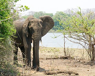
Majete Wildlife Reserve is a nature reserve in southwestern Malawi, established as a protected area in 1955. The reserve's animal populations were decimated during the late 1970s and 1980s due to poaching and other human activities. Majete has been managed by African Parks since 2003, when the nonprofit conservation organization entered into a public–private partnership with the Malawi Department of National Parks and Wildlife (DNPW). Since then, wildlife has been restored, the park has achieved big five game status, and tourism has increased.

Nkhotakota Wildlife Reserve, is the largest and oldest wildlife reserve in Malawi, near Nkhotakota. The park's hilly terrain features dambos and miombo woodlands as the dominant vegetation, which support a variety of mammal and bird species. Poaching has greatly reduced the number of elephants and other large mammals in Nkhotakota, but conservation efforts to restore the elephant population started when African Parks began managing the reserve in 2015.

Vwaza Marsh Game Reserve is a national game reserve in Malawi.
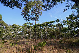
The Central Zambezian miombo woodlands ecoregion spans southern central Africa. Miombo woodland is the predominant plant community. It is one of the largest ecoregions on the continent, and home to a great variety of wildlife, including many large mammals.
African Parks is a non-governmental organization (NGO) focused on conservation, established in 2000 and headquartered in Johannesburg, South Africa. It was founded as the African Parks Management and Finance Company, a private company, then underwent structural changes to become an NGO called African Parks Foundation, and later renamed African Parks Network. The organization manages national parks and protected areas throughout Africa, in collaboration with governments and surrounding communities. African Parks manages 22 protected areas in 12 countries as of May 2023, and employs more than 1,100 rangers. Michael Eustace, Peter Fearnhead, Paul Fentener van Vlissingen, Anthony Hall-Martin, and Mavuso Msimang are credited as co-founders; Fearnhead continues to serve as chief executive officer. Prince Harry was appointed African Parks' president in late 2017.
NBS Bank Limited, commonly referred to as NBS Bank, is a commercial bank in Malawi. It is licensed as a commercial bank, by the Reserve Bank of Malawi, central bank and national banking regulator.

Ulendo Airlink offer both scheduled and non-scheduled commercial air services from their base at Kamuzu International Airport in Lilongwe, Malawi. The company began operations in 2011, and provides services throughout Malawi and the region. The airline currently operates a fleet of six aircraft.

The South Malawi montane forest-grassland mosaic is a montane grasslands and shrublands ecoregion of Tanzania, Malawi, Mozambique, and Zambia.
Ntchisi Mountain is a mountain in central Malawi. It is located in Ntchisi District, east of the town of Ntchisi.
The Misuku Hills are a mountain range in Malawi's Northern Region.
References
- ↑ Mauambeta, Daulos (2010). Status of Forests and Tree Management in Malawi: A Position Paper Prepared for the Coordination Union for Rehabilitation of the Environment (CURE). CURE Technical Report. September 2010 DOI: 10.13140/2.1.3497.7926 Forest Reserve names, areas, and dates established listed in this section are from this source unless otherwise noted.
- ↑ "Bunganya Forest Reserve". Protected Planet, Accessed 1 September 2019
- ↑ "Dwambazi". Protected Planet, Accessed 1 September 2019
- ↑ "Tsamba Forest Reserve". Protected Planet, accessed 1 September 2019.