
Zambia, officially the Republic of Zambia, is a landlocked country at the crossroads of Central, Southern and East Africa. It is typically referred to being in South-Central Africa or Southern Africa. It is bordered to the north by the Democratic Republic of the Congo, Tanzania to the north-east, Malawi to the east, Mozambique to the southeast, Zimbabwe and Botswana to the south, Namibia to the southwest, and Angola to the west. The capital city of Zambia is Lusaka, located in the south-central part of Zambia. The population is concentrated mainly around Lusaka in the south and the Copperbelt Province to the north, the core economic hubs of the country.

Zambia is a landlocked country located in Southern Africa, to the east of Angola. It has a total area of 752,618 square kilometres, of which 9 220 km2 is water.

Malawi is a landlocked country in southeast Africa. It is wholly within the tropics; from about 9°30S at its northernmost point to about 17°S at the southernmost tip. The country occupies a thin strip of land between Zambia and Mozambique, extending southwards into Mozambique along the valley of the Shire River. In the north and north east it also shares a border with Tanzania. Malawi is connected by rail to the Mozambican ports of Nacala and Beira. It lies between latitudes 9° and 18°S, and longitudes 32° and 36°E.

The Zambezi is the fourth-longest river in Africa, the longest east-flowing river in Africa and the largest flowing into the Indian Ocean from Africa. Its drainage basin covers 1,390,000 km2 (540,000 sq mi), slightly less than half of the Nile's. The 2,574 km (1,599 mi) river rises in Zambia and flows through eastern Angola, along the north-eastern border of Namibia and the northern border of Botswana, then along the border between Zambia and Zimbabwe to Mozambique, where it crosses the country to empty into the Indian Ocean.

The Luangwa River is one of the major tributaries of the Zambezi River, and one of the four biggest rivers of Zambia. The river generally floods in the rainy season and then falls considerably in the dry season. It is one of the biggest unaltered rivers in Southern Africa and the 52,000 square kilometres (20,000 sq mi) that make up the surrounding valley are home to abundant wildlife.

Chipata is a city and administrative centre of the Eastern Province of Zambia and Chipata District. It was declared the 5th city of the country, after Lusaka, Ndola, Kitwe and Livingstone, by President Edgar Lungu on 24 February 2017. The city has undergone rapid economic and infrastructure growth in the years, leading up to city status.

Northern Province is one of Zambia's ten provinces. It covers approximately one-sixth of Zambia in land area. The provincial capital is Kasama. The province is made up of 12 districts, namely Kasama District, Chilubi District, Kaputa District, Luwingu District, Mbala District, Mporokoso District, Mpulungu District, Mungwi District, Nsama District, Lupososhi District, Lunte District and Senga Hill District. Currently, only Kasama and Mbala have attained municipal council status, while the rest are still district councils. It is widely considered to be the heartland of the Bemba, one of the largest tribes in Zambia.
Kasama is a city in the Northern Province of Zambia. It serves as the provincial capital and the headquarters of Kasama District.

The Great East Road is a major road in Zambia and the main route linking its Eastern Province with the rest of the country. It is also the major link between Zambia and Malawi and between Zambia and northern Mozambique. However, the route does not carry as much traffic as many of the other regional arterial roads and between the main cities it serves, Lusaka and Chipata, it passes through rural and wilderness areas. In Lusaka the road forms the main arterial road for the eastern suburbs. The entire route from Lusaka to Chipata and the border with Malawi is designated the T4 road on Zambia's road network.

Eastern Province is one of Zambia's ten provinces. The province lies between the Luangwa River and borders with Malawi to the east and Mozambique to the south, from Isoka in the northeast to the north of Luangwa in the south. The provincial capital is Chipata. Eastern province has an area of 51,476 km2 (19,875 sq mi), locally shares border with three other provinces of the country and is divided into fifteen districts.

Southern Province is one of Zambia's ten provinces, and home to Zambia's premier tourist attraction, Mosi-oa-Tunya, shared with Zimbabwe. The centre of the province, the Southern Plateau, has the largest area of commercial farmland of any Zambian province, and produces most of the maize crop.

Nyika National Park is Malawi’s largest national park, with an area of 3200 km2.
Namwanga or Nyamwanga are a Bantu ethnic group native to Momba District in Songwe Region of Tanzania, northeastern Zambia,and Northern Malawi. They speak Nyamwanga or Chinamwanga. In 1993 the Mwanga population was estimated to number 256,000, with 169,000 living in Zambia and 87,000 in Tanzania. At this point, the number of Namwanga people in Malawi is not yet known.
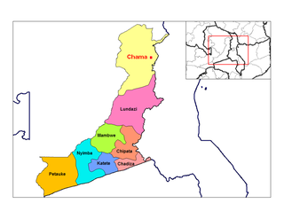
Chama is a small town in the Eastern Province of Zambia, and is headquarters of Chama District. It is one of the most remote district headquarters in the country, lying just inside the eastern edge of the upper Luangwa Rift Valley, at the foot of the highlands dividing Zambia and Malawi. It is served by only one gravel road which comes from Lundazi and the provincial capital of the Eastern Province, Chipata, 300 km to the south. A dirt track connects the town to the South Luangwa National Park 200 km south-west, running parallel to the Luangwa River. A little-used dirt track follows the Malawi border further north and crosses into Isoka District west of the Nyika Plateau. The Road Development Agency is also developing a road from Chama westwards across the Luangwa River to the town of Matumbo, where the road will end at a junction with the T2 Road, Zambia's Great North Road. It is meant to be the 2nd main road out of Chama after the Lundazi-Chipata Route and is meant to provide access for Chama Residents to the headquarters of Muchinga Province, which is Chinsali.
The biomes and ecoregions in the ecology of Zambia are described, listed and mapped here, following the World Wildlife Fund's classification scheme for terrestrial ecoregions, and the WWF freshwater ecoregion classification for rivers, lakes and wetlands. Zambia is in the Zambezian region of the Afrotropical biogeographic realm. Three terrestrial biomes are well represented in the country . The distribution of the biomes and ecoregions is governed mainly by the physical environment, especially climate.
The following outline is provided as an overview of and topical guide to Zambia:

Muchinga Province is one of the ten provinces of Zambia. It is located in the northeast of the country and borders with Tanzania in the north, Malawi in the east, Eastern Province in the south, Central Province in the southwest, Luapula Province in the west, and Northern Province in the northwest. The administrative center of the province is Chinsali.
Mafinga Central is the highest point in the Mafinga Hills on the border of Zambia and Malawi. At 2,339-metre (7,674 ft) it is likely to be the highest mountain in Zambia. It is most easily accessed from the town of Chisenga in Malawi.

The T2 is a trunk road in Zambia. The road runs from the Tunduma border with Tanzania via Mpika, Kabwe and Lusaka to the Chirundu border with Zimbabwe. The road is the longest route of the country, as it is approximately 1,155 kilometres (718 mi). The route from Mpika to Kafue is a toll road. The route from Tanzania to Lusaka is Zambia's Great North Road and is part of the Tanzam Highway.
The M14 is a road in the Muchinga Province of Zambia that connects Nakonde with the Malawian Border at Katumbi via Chitipa, Thendere and Muyombe.
