Luangwa River

Last updated
Luangwa
Luangwa river02.jpg
Luangwa River, southern end near Ndevu
Luangwa.png
Path of the Luangwa River
Location
Country Zambia
Region Eastern Province
Physical characteristics
Mouth Zambezi
  location
near Luangwa, Zambia
Basin features
River system Zambezi

The Luangwa River is one of the major tributaries of the Zambezi River, and one of the four biggest rivers of Zambia. The river generally floods in the rainy season (December to March) and then falls considerably in the dry season. It is one of the biggest unaltered rivers in Southern Africa and the 52,000 square kilometres (20,000 sq mi) that make up the surrounding valley are home to abundant wildlife. [1]

Contents

Source and Upper-Middle Luangwa Valley

Note: distances stated are approximate straight-line distances from source. The Luangwa rises in the Lilonda and Mafinga Hills in north-east Zambia at an elevation of around 1500 m, near the border with Tanzania and Malawi, and flows in a southwesterly direction through a broad valley. About 150 km from its source it has dropped to an elevation of about 690 m and becomes a meandering river with a flood-plain several kilometres wide. Over the next 300 km the meanders increase, with many oxbow lakes and abandoned meanders. Near Mfuwe, the river's elevation has dropped to about 520 m, the flood plain is about 10 km wide and the valley reaches about 100 km wide, with a north-west escarpment (Muchinga Escarpment) about 700 m high, and a south-western escarpment about 450 m high. In the dry season some sections, especially in the upper reaches, dry out completely, leaving isolated pools. [2]

The upper and middle parts of the valley contain the North Luangwa National Park and South Luangwa National Parks of Zambia, which are among some of the finest in Africa. The river itself is home to large populations of hippopotami and crocodiles. The world's largest concentration of hippos lives in the Luangwa Valley. In the dry season they are restricted by the shrinking river and pools, and are easily seen especially in isolated pools. [3] [ citation needed ]

Luangwa River, 10 km south of Luangwa Bridge Luangwa river.jpg
Luangwa River, 10 km south of Luangwa Bridge

In addition to being a source of water, the oxbow lakes and pools increase the biodiversity of the valley in other ways. The hippopotami which live in them feed on land vegetation at night. Their dung feeds some fish and fertilises the pools, increasing fish life which in turn feed crocodiles and birds. [4] [ citation needed ]

In the dry season, the grazing land animals and their predators congregate near the river and pools, and are easily seen. In the rainy season they graze further afield and are more easily hidden in the growth of new vegetation.

At about 500 km the valley narrows to about 50 km and becomes divided by a ridge into two parallel valleys, with a tributary, the Lukusashi River in a 25 km-wide valley to the north-west, and the Luangwa in a 15 km wide valley to the southeast. The river meanders less, and the flood plain narrows.

The principal settlement in the Middle and Upper Luangwa Valley is Mfuwe which serves the tourism industry and has an international airport. Very few humans otherwise inhabit the valley. [5] [ citation needed ]

Lower Luangwa

At 600 km the river abruptly enters a narrow valley between hills rising some 200 m from the broader valley floor, becoming almost a gorge. About 700 km from source the Luangwa merges with its tributary the Lukusashi after the latter has merged with the Lunsemfwa River coming from the opposite direction, and turns due south through a steep narrow valley: this is its exit from the Luangwa Rift Valley (see following section). After only 20 km it emerges from the hills into the broad valley of the Zambezi and meanders over sandy flats about 1.5 km wide in a flood plain of 3–5 km wide. It merges with the deeper Zambezi at Luangwa town. [6] [ citation needed ] The lower section of the river forms the border between Zambia and Mozambique. [7]

The Luangwa Rift Valley

This section explains the geomorphology of the Luangwa Valley. It is a rift valley or graben forming a south-west extension of the east African Rift, branching off its Lake Rukwa-Lake Malawi southern section, and reaching almost as far as Lusaka. The junction is not obvious because it filled with material spewed out from an ancient, extinct volcano. There are at least 20 hot springs, characteristic of a rift valley, in the valley or on its escarpments. [8] [ citation needed ]

The Luangwa flows along four-fifths of the Luangwa Rift Valley to the point where it meets the Lukusashi and the Lunsemfwa which has come from the opposite direction. At one time, millions of years ago, there was no way out and the Luangwa Rift filled with a Rift Valley Lake called the Madumabisa Lake, which rivalled Lake Malawi in size. The water of the lake overflowed in a river to the south-west, towards what is now the Kalahari, where it combined with the Okavango, Upper Zambezi, Cuando and Kafue rivers, emptying into the Limpopo River and flowing to the Indian Ocean. [9] [ citation needed ]

Several geological events combined to produce the current river systems. Faulting produced another graben just to the south of the Luangwa Rift, and running east–west: the Zambezi Rift Valley and the Chicoa Trough. A tributary of the Shire River at the south end of the Great Rift Valley then cut back eastwards through the Chicao Trough and Zambezi Valley, capturing the southerly overspill of the Madumabisa Lake. This tributary became the Zambezi, which over millions of years captured the Kafue, Cuando and the upper Zambezi. Faulting lowered the land between the Luangwa Rift and the Zambezi Rift allowing Madumabisa Lake to drain out into the Zambezi in a channel which became the lower Luangwa River. [10] [ citation needed ]

The Luangwa merges with Zambezi River. Confluence of Zambezi and Luangwa rivers 20.jpg
The Luangwa merges with Zambezi River.

The Luangwa as a barrier

The Luangwa Rift Valley and rivers within it form a natural barrier, with a very low population density. This, the steepness of the terrain, and the existence of the wildlife reserves have resulted in no highways crossing the valley between the Lusaka-Kabwe roads in the west and the Isoka-Chisenga road in the north, a distance of about 800 km. The lower Luangwa Valley is crossed by just one road, the Great East Road at the Luangwa Bridge, about 10 km south of the Luangwa-Lunsemfwa confluence. [11] [ citation needed ]

Further reading

Related Research Articles

<span class="mw-page-title-main">Zambezi</span> Major river in southern Africa

The Zambezi is the fourth-longest river in Africa, the longest east-flowing river in Africa and the largest flowing into the Indian Ocean from Africa. Its drainage basin covers 1,390,000 km2 (540,000 sq mi), slightly less than half of the Nile's. The 2,574 km (1,599 mi) river rises in Zambia and flows through eastern Angola, along the north-eastern border of Namibia and the northern border of Botswana, then along the border between Zambia and Zimbabwe to Mozambique, where it crosses the country to empty into the Indian Ocean.

<span class="mw-page-title-main">Lake Mweru Wantipa</span> Lake and swamp system in northern Zambia

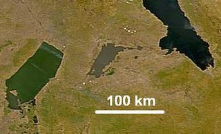
Lake Mweru Wantipa or Mweru-wa-Ntipa meaning "muddy lake" is a lake and swamp system in the Northern Province of Zambia. It has been regarded in the past as something of mystery, displaying fluctuations in water level and salinity which were not entirely explained by variation in rainfall levels; it has been known to dry out almost completely. This is compounded by its remoteness and it not receiving the same attention from geographers and geologists as its larger and more accessible neighbours, Lake Tanganyika, 25 km east, and Lake Mweru, 40 km west, with which its name is sometimes confused.

<span class="mw-page-title-main">Kafue River</span> River in Zambia

The Kafue River is the longest river lying wholly within Zambia at about 1,576 kilometres (979 mi) long. Its water is used for irrigation and for hydroelectric power. It is the largest tributary of the Zambezi, and of Zambia's principal rivers, it is the most central and the most urban. More than 50% of Zambia's population live in the Kafue River Basin and of these around 65% are urban.

<span class="mw-page-title-main">Kafue</span> Town in Lusaka Province, Zambia

Kafue is a town on the T2 road in the Lusaka Province of Zambia and it lies on the north bank of the Kafue River, after which it is named. It is the southern gateway to the central Zambian plateau on which Lusaka and the mining towns of Kabwe and the Copperbelt are located.

Mbala is Zambia's most northerly large town and seat of Mbala District in Northern Province, occupying a strategic location close to the border with Tanzania and controlling the southern approaches to Lake Tanganyika, 40 km by road to the north-west, where the port of Mpulungu is located. It had a population of about 20,000 in 2006. Under the name Abercorn, Mbala was a key outpost in British colonial control of this part of south-central Africa.

<span class="mw-page-title-main">South Luangwa National Park</span> National park in Zambia

South Luangwa National Park is in eastern Zambia, the southernmost of three national parks in the valley of the Luangwa River. It is a world-renowned wildlife haven which is known to locals simply as "the South Park." Concentrations of game along the meandering Luangwa River and its lagoons are amongst the most intense in Africa. The river teems with hippo and crocodile and provides a lifeline for one of the greatest diversities of habitat and wildlife, supporting more than 60 species of mammals and over 400 species of birds. It marks the end of the Great Rift Valley.

<span class="mw-page-title-main">Mongu</span> City in Western Province, Zambia

Mongu is the capital of Western Province in Zambia and was the capital of the formerly-named province and historic state of Barotseland. Its population is 179,585, and it is also the headquarters of Mongu District. Mongu is the home of the Litunga, King of the Lozi people.

<span class="mw-page-title-main">Lunsemfwa River</span>

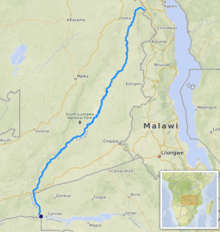
The Lunsemfwa River is a tributary of the Luangwa Rivers in Zambia and part of the Zambezi River basin. It is a popular river for fishing, containing large populations of tigerfish and bream.

<span class="mw-page-title-main">Great East Road</span> Major road in Zambia

The Great East Road is a major road in Zambia and the main route linking its Eastern Province with the rest of the country. It is also the major link between Zambia and Malawi and between Zambia and northern Mozambique. However, the route does not carry as much traffic as many of the other regional arterial roads and between the main cities it serves, Lusaka and Chipata, it passes through rural and wilderness areas. In Lusaka the road forms the main arterial road for the eastern suburbs. The entire route from Lusaka to Chipata and the border with Malawi is designated the T4 road on Zambia's road network.

<span class="mw-page-title-main">Lusaka Province</span> Province of Zambia

Lusaka Province is one of the ten provinces of Zambia. Its capital is Lusaka, which is also the national capital. It is the smallest province in Zambia, with an area of 21,896 km2. Lusaka is also Zambia's most populated and most densely populated province, with a population of 3,079,964 and density of 140 persons per km2 as of 2022. It is the most urban province, with the most doctors and fewest malaria-related incidents. The province is bordered by Zimbabwe and Mozambique, and separated by the Lower Zambezi National Park.

Zambezi Escarpment is a name used for the escarpments forming both sides of the rift valley or graben in which lie the middle Zambezi river and Lake Kariba. They are fault scarps, rising 500 to 600 m higher than the lake or river, running from the Batoka Gorge roughly 800 km to the lower Zambezi, and facing each other about 50 to 100 km apart, closer in the west and opening up in the east.

<span class="mw-page-title-main">Luangwa Bridge</span>

The Luangwa Bridge is the only large bridge and the principal engineering challenge on Zambia's Great East Road, crossing the lower Luangwa River where it flows from the Luangwa Rift Valley into the Zambezi valley.

<span class="mw-page-title-main">Mulungushi River</span>

The Mulungushi River in central Zambia is a tributary of the Lunsemfwa River and a part of the Zambezi River basin. It rises on the plateau north-west of Kabwe and flows south-east into the Luangwa Rift Valley where it joins the Lunsemfwa.

Water transport and the many navigable inland waterways in Zambia have a long tradition of practical use except in parts of the south. Since draught animals such as oxen were not heavily used, water transport was usually the only alternative to going on foot until the 19th century. The history and current importance of Zambian waterways, as well as the types of indigenous boats used, provide information on this important aspect of Zambian economy.

<span class="mw-page-title-main">Wildlife of Zambia</span>

The wildlife of Zambia refers to the natural flora and fauna of Zambia. This article provides an overview, and outline of the main wildlife areas or regions, and compact lists of animals focusing on prevalence and distribution in the country rather than on taxonomy. More specialized articles on particular groups are linked from here.

<span class="mw-page-title-main">Climate of Zambia</span>

The climate of Zambia in Central and Southern Africa is definitely tropical modified by altitude (elevation). In the Köppen climate classification, most of the country is classified as humid subtropical or tropical wet and dry, with small patches of semi-arid steppe climate in the south-west.

The biomes and ecoregions in the ecology of Zambia are described, listed and mapped here, following the World Wildlife Fund's classification scheme for terrestrial ecoregions, and the WWF freshwater ecoregion classification for rivers, lakes and wetlands. Zambia is in the Zambezian region of the Afrotropical biogeographic realm. Three terrestrial biomes are well represented in the country . The distribution of the biomes and ecoregions is governed mainly by the physical environment, especially climate.

<span class="mw-page-title-main">Outline of Zambia</span> Overview of and topical guide to Zambia

The following outline is provided as an overview of and topical guide to Zambia:

Zambia, officially known as the Republic of Zambia, is a landlocked country in Southern Africa. The neighbouring countries are the Democratic Republic of the Congo to the north, Tanzania to the north-east, Malawi to the east, Mozambique, Zimbabwe, Botswana, and Namibia to the south, and Angola to the west. The capital city is Lusaka, located in the southeast of the country. The population is concentrated mainly around the capital and the Copperbelt to the northwest.

The Urema Valley, also known as the Urema Graben, is a lowland valley in Sofala Province of central Mozambique.

References

  1. Christine Eckstrom (May 2007). "Waiting for thunder". National Geographic . Archived from the original on 2007-11-24. Retrieved 2007-04-30.
  2. Gilvear, David; Winterbottom, Sandra; Sichingabula, Henry (April 2000). "Character of channel planform change and meander development: Luangwa River, Zambia". Earth Surface Processes and Landforms. 25 (4): 421–436. doi:10.1002/(sici)1096-9837(200004)25:4<421::aid-esp65>3.0.co;2-q. ISSN   0197-9337.
  3. "Luangwa River In Zambia". AfricanMecca Safaris. Retrieved 2021-05-22.
  4. "Hooray for hippos". Africa Geographic. 2016-02-12. Retrieved 2021-05-22.
  5. "Luangwa River In Zambia". AfricanMecca Safaris. Retrieved 2021-05-22.
  6. "Luangwa River". Zambia Tourism. Retrieved 2021-05-22.
  7. "Luangwa River". Britannica. Retrieved 2021-12-04.
  8. "Luangwa River". Zambia Tourism. Retrieved 2021-05-22.
  9. "Safari in Botswana and Zambia | Zicasso". www.zicasso.com. Retrieved 2021-05-22.
  10. "David Shepherd CBE, Buffalo, Luangwa Valley, Zambia". Rountree Tryon. Retrieved 2021-05-22.
  11. "Luangwa Bridge High Resolution Stock Photography and Images - Alamy". www.alamy.com. Retrieved 2021-05-22.

15°34′28″S30°23′20″E / 15.57443°S 30.38887°E / -15.57443; 30.38887