The highest stacks in Scotland are Stac an Armin and Stac Lee in the St Kilda archipelago and the Old Man of Hoy, Orkney. Some provide well known and challenging rock climbing routes. There are 275 or more stacks in the country; their names are influenced by the Norse, Gaelic and English languages. In Shetland, where there are over 100 stacks, the names are often from Norn, a local variant of Norse.
The sport of stack climbing did not take off until the mid-1960s with the exploits of Tom Patey and in July 1967 15 million people watched the climbing of the Old Man of Hoy live on BBC television. The idea was originally suggested by Patey who helped put together a team of six climbers who were filmed undertaking the ascent. This was described as connecting "an armchair audience with the elite of a sport subculture intent on conquering one of Britain's most spectacular geological treasures”.[3] Following Patey's untimely death in 1970 development of the sport in Scotland largely ceased until the late 1980s and the arrival of Mick Fowler on the scene.[4]
Cleare (1974) defined stacks from a rock-climbing perspective using three criteria:
"A stack should be higher than it is wide in at least one of its planes.
Within reason there is no minimum height, except that if it is high enough to be worth climbing, then it's a stack.
A stack should have been formed by the action of the sea."[6]
Mellor (2020) offers similar conditions: "a stack is an isolated cone, pinnacle or tower of rock entirely surrounded by the sea at high tide."[7] He goes on to suggest that the difference between a stack and an island is that if the top is significantly wider in diameter than the height then it is an island, and that a stack should be at least 6 metres (20ft) high.[7]
From a geological perspective a stack is a landform consisting of a steep and often vertical column or columns of rock in the sea near a coast, formed by wave erosion.[8] This definition excludes isolated steep-sided, rocky oceanic islets typically of volcanic origin, sometimes called "volcanic stacks". In the main listing below three different types of stack are identified:
Sea stacks
Outlying stacks, many of which are of volcanic origin
Wide stacks that fail Mellor's definition of height to summit diameter above but which either have "stack" in their name or are clearly a "tower of rock entirely surrounded by the sea".
There are numerous small pinnacles around the Scottish coast, many of them in remote locations. Such features are often not well-documented and the main list is thus confined to the larger and better known examples.
The word 'stack' is derived from the Old Norse: stakk-r and is often rendered in the Norn of Shetland as stakk[10] and in modern Gaelic as stac or the plural stacan.[11]
Several descriptive names are used in more than one location. Examples include:
Gaada Stack, meaning "hole stack" and used to describe stacks that incorporate natural arches;[12]
Moo Stack, of which there are at least four in Shetland;[13]
Brough, which is cognate with Old Norse: borg meaning "fortification" and broch;[14]
Castle, Scottish Gaelic: caisteal, is typically used for an isolated stack;[15]
The name "stack" is however also sometimes appended to features other than sea stacks such as cliff-girt headlands and a number of such features are also listed below.
Distribution
Of the 275 stacks in Scotland identified by Mellor (2020) circa 110 are located around the coasts of Shetland of which 80 are around the coast of the Mainland. Most of the rest are found off the coasts elsewhere in the Highlands and Islands. He also lists 70 stacks in England, 10 in Wales and 55 off the island of Ireland.[17]
Climbing history
"Landing place on Stac Lii", illustration from Climbing in St Kilda by Norman Heathcote
The first stack climbers in Scotland were the residents of the now uninhabited islands of Hirta and Mingulay who were dependent on the bounty provided by seabirds.[18][19] The first record of the recreational ascent of a sea stack in Scotland is likely that of Richard Manliffe Barrington, who climbed Stac Biorach in 1883.[Note 1] Sixteen years later Norman Heathcote and his sister Evelyn climbed Stac Lee.[26] He wrote that Stac Lee was "not a difficult climb" and that two other women had also reached the summit.[27]
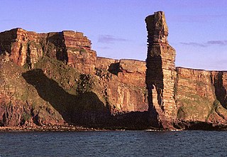
Nonetheless, the main theme of the sport in the UK until the mid-1960s was "incidental stack climbing in pleasant and accessible locations".[20] Yorkshireman Ian Clough ascended one of Macleod's Maidens on Skye in 1959 but the picture changed completely with the exploits of Tom Patey, (aka "Doctor Stack") whose day job was as a GP in Ullapool. He began with the Old Man of Stoer in 1966 and followed this up with ascents of Am Buachaille, the Old Man of Hoy and the Great Stac of Handa.[20] After his death when descending The Maiden in 1970 "most Scottish stack explorations abruptly ceased".[28]
There was then a hiatus of a dozen years as climbers began "putting up harder and harder lines on comfortable stacks until they felt strong enough to venture north again".[28] In 1982 Arnis Strapcans put up a new route on the Old Man of Hoy. Two more routes were created on this stack in 1984 and with the arrival on the UK scene of Mick Fowler in 1985 events moved apace. He climbed the Old Man of Stoer in 1988 and numerous others over the next few years, "his most outrageous adventure" being on The Needle, another stack off the west coast of Hoy.[4] His regular partners on these exploits were Andy Nisbett, Craig Jones and Jon Lincoln who made up the "famous four" completing, for example, the first ascent of The Runk in Shetland in May 1992.[29]
Irishman Iain Miller made a solo second ascent of the Clett of Crura, South Ronaldsay in 1999 and since then has been involved in about 150 first ascents around Britain and Ireland. Nonetheless, in 2020 it was estimated that over 50 stacks around the British Isles have never been climbed.[30]
In 2019 Red Széll became the first blind climber to ascend the three “Tom Patey stacks” of Am Buachaille, the Old Man of Stoer and the Old Man of Hoy.[31] The 2020 film Climbing Blind documents the first blind lead of the Old Man of Hoy by Jesse Dufton.[32][33]
In 2023, by arrangement with the National Trust for Scotland, Stac Biorach was ascended again 130 years after Barrington became the first non-St Kildan to do so. Climber Robbie Phillips said it "was like walking in the footsteps, or climbing in the fingerprints, of the St Kildans. It’s a testament to their bravery and mental fortitude; to climb onto that sea stack 70m above the raging Atlantic without even shoes is wild to imagine".[22]
Main list
These are stacks which are well-known local landmarks greater than 15m in height, prominent rock climbing pinnacles, notable isolated stacks or are verified as being greater than 50 metres (160ft) in height.
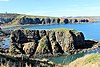
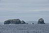
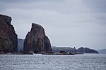
There are three large stacks here - Erne's Stack, a 55m stack southeast of Westerwick[41] Erne's Stack North, which reaches 51m[62] and Erne's Stack East, at 35m high.[63]
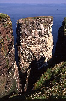
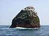
The highest sea stack in Scotland. Three men and eight boys from Hirta were marooned here from about 15 August 1727 until 13 May 1728.[90] In July 1840, the last great auk seen in Britain was caught on the stack.[91]
Scottish Gaelic: clò has various meanings including "sea". Old Norse: ker means "sailing vessel".[95] This may then be "stack of the sea-galley bay".[96]
There are two summits, both first ascended in June 1989.[97]
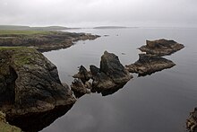
Consists of 4 stacks; Main Drong, Slender Drong, Slim Drong and Stumpy Drong.[106] They lie one kilometre off the coast of Hillswick Ness, Northmavine.[41]
This is a selection of the many other stacks in Scotland. All the below are included in Mellor (2020) except those with the symbol № which have been identified from Ordnance Survey maps and/or other sources as cited. According to Mellor there is no record of some of them having been climbed.
Stacks of Houssness at the south end of East Burra
Fugla Stack, a 33m high stack[41] west of The Ward, West Burra
Clettnadel, a small stack just north of Fugla Stack
Kame of Riven Noup, a "wafer-like entity" north of Clettnadel.[127] The name may mean "comb of the torn headland" and is the subject of a poem by Martha Morton from Brae.[128]
Stack of Sandwick has an arch is and is located west of Bridge End, West Burra
Unnamed stack at Ness of Collaster, UnstCudda Stack, Unst
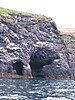
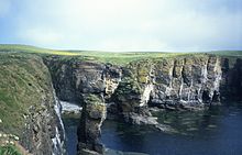
As with elsehere on Shetland the profusion of offshore islets and stacks create definitional problems. For example, The Greing north of Urda Stack is 53m high and is steeply sloping on one side and perpendicular cliffs on the other so not included.[131] The name "stack" is also sometimes used for a headland, e.g. Sothers Stack, Hermaness or the nearby 55m high Humla Stack,[132] which are included in Mellor's list of possible candidates[133] or for rocky islets that come nowhere near meeting the definitions above e.g. Breiwick Stack, which is more of a skerry.[134]
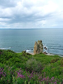
Erne Stack on Muckle Roe is "connected to the shore by a thin neck".[143]
Ern Stack, Yell is a prominent feature with twin towers of white rock first climbed in 1980. It is also the last recorded nesting site of the Eurasian sea eagle in Shetland. However it is not sea-encircled.[9][144]
↑ This ascent of Stac Biorach is the subject of a number of conflicting assertions. Mellor has this FA taking place in 1883 by "a C. Barrington".[20] Similarly, Haswell-Smith describes the training of young St Kildan's on the stack recorded in 1698 and then states that "The first recorded outsider to climb both this stack and Stac Lee was Charles Barrington in 1883".[21] This refers to Richard's brother Charles who would have been 49 years old in 1883. Quine also states that the FA was in that year but by Richard Barrington.[5] The National Trust for Scotland have R. Barrington as the climber but the date as 1890.[22] There is thus confusion about both the date of the ascent and which brother was the ascender. However, R. Barrington was 16 years younger than Charles and the Dictionary of Irish Biography makes it clear that it was the former who travelled to "remote islands off Scotland (1883, 1886, 1890)".[23] The original paper by R. Barrington in the Alpine Journal in 1913 also states that the year of the ascent was 1883 and that he ascended the stack with the help of two St Kildans, Donald McDonald and Donald McQueen.[24] Barrington wrote “the fact that a certain rivalry existed between myself and an elder brother who first ascended the Eiger induced me to visit St. Kilda in 1883, as I wished to test the ability of the natives as cragsmen, to compare them with Swiss guides, and to study the fauna and flora of this remote island, of which little was then known. It is thirty years ago next June since I ascended Stack-na-Biorrach, and therefore I trust I shall not be accused of hasty self-advertisement”.[25]
↑ Gazetteer for Scotland states the FA was in 1968.
↑ Quine (2000) suggests the name may mean Blue Stack "if Scandinavian... otherwise, Place of Splashing".[40]
↑ Although the Mingulay outliers of Aranamul and Lianamul do not necessarily meet rock climbing definitions of a stack, they are often referred to as such by writers with other interests e.g. Haswell-Smith,[44] Buxton and Harvie-Brown.[45]
↑ There are several stacks on Tràigh Ghearadha that increase in size from north to south. Caisteal a' Mhorair is the tallest of these at right on this image. See Canmore for an aerial photo.[50]
↑ Probably referred to as "Grey Castle" by Mellor (2020), which he lists as 70m in height.[51]Canmore has a more realistic figure of 70 feet (21m).[50]
↑ Witch’s Hat Stack would seem to be, on the evidence of Mellor (2020) and elsewhere, the highest stack off the coast of the island of Great Britain but no source specifically confirming this has yet been found.
↑ The stack is in the middle distance, at the southern extremity of Bay of Deepdale in this image. The much smaller Litla Stack is also shown in front of Erne's Stack.
↑ Brei Holm is at right with Maiden Stack immediately to its left. An unanmed stack in front of Maiden Stack appears as if joined to it to the left of the highest point.
↑ Gazetteer for Scotland has "approximately 70m". A second source states 61m.[80]
↑ Quine (2000) describes Stac Biorach as "almost inaccessible" and adds that "even the St Kildans stopped climbing it around 1840".[94] However, this cannot be entirely true given their assistance to Barrington in 1883.[24]
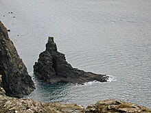
↑ Stac Shoaigh at right with Stac Biorach at left.
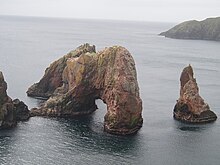
↑ The Maiden at right with the "western stack" at left.[108]
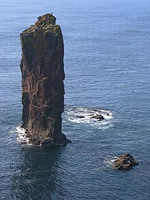
↑ There is an image of the area at Geographhere. The Needle is at right just to the left of the entrance to the narrow geo at far right.[41]
↑ The location is not clear and it may be a stack on the many cliffs in that area rather than a sea stack.
↑ Mellor (2020) lists Am Bhiran at the same location, which may be the smaller of the two stacks in the image.
Hoy is an island in Orkney, Scotland, measuring 143 square kilometres (55 sq mi) – the second largest in the archipelago, after Mainland. A natural causeway, the Ayre, links the island to the smaller South Walls; the two islands are treated as one entity by the UK census.
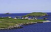
Muckle Roe is an island in Shetland, Scotland, in St. Magnus Bay, to the west of Mainland. It has a population of around 130 people, who mainly croft and live in the south east of the island.
Sgùrr Dearg is a mountain in the Cuillin on the Isle of Skye, Scotland. It is topped by the Inaccessible Pinnacle, a fin of rock measuring 50 metres (160 ft) along its longest edge. The top of the Pinnacle stands at 985.8 m (3,234 ft) above sea level, making Sgùrr Dearg the only Munro with a peak that can only be reached by rock climbing. This makes it the biggest hurdle for many Munro baggers.
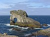
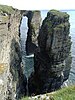
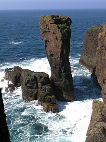
The Old Man of Hoy is a 449-foot (137-metre) sea stack on Hoy, part of the Orkney archipelago off the north coast of Scotland. Formed from Old Red Sandstone, it is one of the tallest stacks in the United Kingdom. The Old Man is popular with climbers, and was first climbed in 1966. Created by the erosion of a cliff through hydraulic action some time after 1750, the stack is not more than a few hundred years old, but may soon collapse into the sea.
The Merrick, or simply Merrick, is a mountain in the Range of the Awful Hand, a sub-range of the Galloway Hills range, part of the Southern Uplands of Scotland. The summit elevation is 843 metres, making it the highest mountain in the Southern Uplands and southern Scotland.
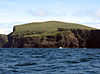
Stac Lee is a sea stack in the St Kilda group off the west coast of Scotland. An island Marilyn, it is home to part of the world's largest colony of northern gannet.
Stac an Armin, based on the proper Scottish Gaelic spelling, is a sea stack in the St Kilda archipelago. It is 196 metres (643 ft.) tall, qualifying it as a Marilyn. It is the highest sea stack in Scotland and the British Isles.
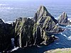
Stac Biorach is a sea stack, 73 metres tall, situated between Hirta and Soay in the St Kilda archipelago of Scotland. It lies west of Stac Shoaigh (61 metres).
An Ruadh-stac is a Scottish mountain situated in the Wester Ross region of the Highland council area. It is located 26 km north east of Kyle of Lochalsh.
Stac Levenish or Stac Leibhinis is a sea stack in the St Kilda archipelago in Scotland. Lying 2.5 kilometres off Village Bay on Hirta, it is part of the rim of an extinct volcano that includes Dùn, Ruaival and Mullach Sgar.
Duirinish is a peninsula and civil parish on the island of Skye in Scotland. It is situated in the north west between Loch Dunvegan and Loch Bracadale.
Bearasaigh or Bearasay is an islet in outer Loch Ròg, Lewis, Scotland. During the late 16th and early 17th centuries it was used as a pirates' hideout and the remains of various buildings from that period still exist. In the modern era its cliffs are used for rock-climbing.
Funzie Girt is an ancient dividing wall that was erected from north to south across the island of Fetlar in Shetland, Scotland. Some sources describe it as having been built in the Neolithic, but the date of construction is not certainly known. The line of the wall, which ran for over 4 kilometres (2.5 mi), once divided the island in two almost equal sections. Also known as the Finnigirt Dyke, it has vanished in places at the southern end, although the ruins are clearly visible along much of the uninhabited north of the island, where it is a conspicuous feature of the landscape. The dyke's original purpose is not known, nor is its relationship to other archaeological sites of a similar age nearby. There are various folk tales about its construction, and it is the subject of various pieces of Shetland folk music.
St Magnus Bay is a large coastal feature in the north-west of Mainland Shetland, Scotland. Roughly circular in shape with a diameter of about 19 kilometres (12 mi), it is open to the North Atlantic Ocean to the west. The indented coastline to the north, south and east between Esha Ness in the north and the Ness of Melby in the south contains numerous bays, firths and voes and there are several islands around the perimeter. The waters of the bay are up to 165 metres (541 ft) deep and may have been the site of a substantial meteor impact.
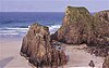
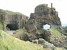
The Drongs are a group of sea stacks off the coast of Hillswick Ness, Northmavine, Shetland, Scotland. They lie to the west of the Isle of Westerhouse in St Magnus Bay. They have been described as "a focus of interest from all surrounding parts, including Eshaness", from which they are the most readily viewed, and as such are considered an icon of Eshaness, along with the famous Dore Holm.
References
Cleare, John (1974). "Sea Stacks". Alpine Journal. 79. London: The Alpine Club: 47-54.
Barrington, Richard M. (1913). "The Ascent of Stack-Na-Biorrach (The Pointed Stack), St Kilda". Alpine Journal. 27. London: Longmans, Green: 195-202.
Buxton, Ben (1995). Mingulay: An Island and Its People. Edinburgh: Birlinn. ISBN1-874744-24-6.
Gammeltoft, Peder (2006). "Scandinavian influence on Hebridean island names". In Gammeltoft, Peder; Jorgenson, Bent (eds.). Names through the Looking-Glass. Copenhagen: C.A. Reitzels Forlag. ISBN8778764726.
Quine, David (2000). St Kilda. Grantown-on-Spey: Colin Baxter Island Guides. ISBN1-84107-008-4.
Rackwitz, Martin (2007). Travels to Terra Incognita: The Scottish Highlands and Hebrides in Early Modern Travellers' Accounts C. 1600 to 1800. Waxmann Verlag. ISBN978-3-8309-1699-4.
Taylor, A. B. (1968). "The Norsemen in St Kilda". Viking Society for Northern Research. 17. JSTOR: 116–144. Retrieved 24 March 2024.
This page is based on this Wikipedia article Text is available under the CC BY-SA 4.0 license; additional terms may apply. Images, videos and audio are available under their respective licenses.


