Kirkmaiden

Last updated

Kirkmaiden
Dumfries and Galloway UK location map.svg
Red pog.svg
Kirkmaiden
Location within Dumfries and Galloway
Population685 (2001)
OS grid reference NX1236
Civil parish
  • Kirkmaiden
Council area
Lieutenancy area
Country Scotland
Sovereign state United Kingdom
Post town Stranraer
Postcode district DG9
Dialling code 01776
Police Scotland
Fire Scottish
Ambulance Scottish
UK Parliament
Scottish Parliament
List of places
UK
Scotland
54°41′35″N4°54′40″W / 54.693°N 4.911°W / 54.693; -4.911 Coordinates: 54°41′35″N4°54′40″W / 54.693°N 4.911°W / 54.693; -4.911

Kirkmaiden is a parish in the Rhins of Galloway, the most southerly in Scotland; the present Church of Scotland parish has the same name as and is approximately coterminous with the original pre-Reformation parish.

Contents

The parish takes its name from the clachan or hamlet of Kirkmaiden, itself named after the mediaeval St Medan, whose identity, name, sex and origin are all disputed. [1] The name "Kirkmaiden" itself is thought to be a corruption of a purer Gaelic "Kilmaiden" by either Scandinavians or Angles with a knowledge of Gaelic. [2]

It is also the area and name of a community council, which meets generally in Drummore and occasionally in Port Logan.

Settlements

There are two main settlements in Kirkmaiden: Drummore and Port Logan. The small hamlet of Kirkmaiden itself, which contains the present-day church, is about a mile west of Drummore.

Ecclesiastical history

The parish church was originally some five miles south of Drummore, at a site on the Kirkburn, not far from the Mull of Galloway; the name of the nearest cove, Portankill, suggests that originally many worshippers attended Mass by boat. [1] The church was dedicated to the Virgin Mary; and in a cave on the eastern shore of the parish at some time a hermit lived. [3] On 15 July 1393 Pope Clement VII authorised Finlay, Abbot of Soulseat, to annex Kirkmaiden parish church in ‘le Rynnis’ to augment the income of the abbey. [4]

In 1638 the parishioners, citing the inconvenience of the journey to church, secured the building of a new church known as Kirk Covenant on Core Hill, about a mile west of Drummore. The patron was the Earl of Stair.

Following the Disruption of 1843, a new church was again built, for worshippers in the Free Church of Scotland, and this time in the village itself, in the street now known as Stair Street. Early in the 20th century the two congregations were reunited. Now worship is habitually at the church within Drummore, with one service each month in the summer being held at Kirk Covenant.

Iron Age and early middle ages

A substantial earthwork, measuring 400 m long, cuts off an area of about 57 ha at the eastern end of the Mull of Galloway. In most places it comprises three ditches with medial banks, the inner bank being the larger, measuring between 3.1 m and 4 m in thickness with an external height of up to 2.2 m. It is believed the ramparts make this the largest Iron Age stronghold in Britain. [5] It is situated 330 m south-southeast of the earthwork at the Tarbet.

About 330 m north-northwest of the above earthwork, and situated at the narrow isthmus between the bays of East and West Tarbet, an earthwork cuts across the neck of the Mull of Galloway south of the enclosed fields of the Mull farm. The bank is 2.3 m wide and 0.5 m high with possible facing stones exposed.

Late middle ages

The Gordons of Clanyard Castle were powerful men in the area, and their daughters married into Kirkmaiden families. [6] Alexander Gordon of Castle Clanyard received a bell cast in AD1534 for Kirkmaiden Church. [7] A very interesting Castle Clanyard Reconstruction in Sketchup is on YouTube.

Killumpha Tower [8] is another tower house in the parish.

Early modern period

The population of the parish was 1,051 in 1755, 1,380 in the 1790s and 1,613 in 1801. [9] In 1790 the Statistical Account reported abundance of fish including oysters and lobsters, corn and cattle; plentiful potatoes and other vegetables; quantities of thriving barley and oats; and flax. Trees, however, did not thrive. The farmers improved their land with lime, which was brought from Whitehaven or Ireland. [3] At that time a number of endowments for the poor of the parish are mentioned, including £100 from Andrew McMurray a merchant in London, £100 from Andrew McDowal (Lord Bankton, one of the judges of the Court of Session: the McDowal family were lairds of Logan), and £400 from William Adair of Flixton, [10] all three of whom had been born in the parish. The nearest market was in Stranraer, and there were three schools and three licensed ale-houses. [11]

Archaeology

See Archaeological and Historical Collections relating to Ayrshire and Galloway. vol. V. pp. 62–63 by Rev. George Wilson wherein he describes forts : (a) 2 across the narrow isthmus from east to west Tarbert. (b) One north-west of West Tarbert, not on O.S. map. (c) Dunora or Dunorrich. (d) Three forts with only traces of ditch. (e) Dunman, a large fort. (f) Crummag Head, a circular stone fort. (g) One between Clanyard and Logan Bay. (h) Dunichinie, large circular fort north of Mull of Logan. (i) Moat Hill at Drummore. [12]

(e) Dunman Fort an Early Iron Age Fort on the western shore of the Rhins. The defences along the inner crests of the natural gullies on the north-east and south-east consisted of a wall originally 8'-12' thick. The internal measurement is about 110m north-west by 100m south-east, but no structures were visible in the interior. There are entrances on the north to north-east and south, with a possible third on the north where a natural terrace provides access to the interior immediately beyond the end of the wall.

Walling is visible on the north, east and south sides and some on the east, consisting of an inner wall face and heather-covered rubble about 3.0m wide. The wall which follows the crest of a scarp over 7m high around the north, east and south sides of the summit. The wall peters out on the north and south to south-west, and there are no visible defences on the west where the ground falls away steeply to the sea 150m below.

There are four approaches to the fort, but only one, in the north-east is faced as an entrance. A shallow hollow descends the scarp at the north to north-east entrance, which is blocked with three large boulders. At the south entrance a natural terrace drops obliquely down the scarp into a hollow 2.5m broad with a bank up to 3m thick and 0.6m high on its outer lip.

(f) Crammag Head on the western shore of the Rhins was circular dun or broch with outworks about 19.5m in diameter over all, but its wall has been reduced to little more than the basal course of the outer face around the west. The granite facing-stones measure up to 1m in length by 0.65m in breadth and 0.65m in height, and a maximum of three courses is visible on the north-west.

The interior on the west, which is now occupied by Crammag Head Light, has been raised up to 1.8m above the outer face with material from a ditch immediately east of the dun.

The ditch is broken by a causeway 2.5m wide which is faced with granite boulders along its south-side. To the north of the causeway the ditch measures 9m in breadth and varies from 1.3m in depth externally to 2m internally, but to the south it is only 6.5m in breadth and 1.1m in depth. The ditch is only visible at the southern end of the rampart and measures up to 5.5m in breadth by 0.3m in depth. The entrance through the outer defence was probably at its southern end where the rampart and ditch stop 3m and 5m short of the edge of the promontory respectively.

About 20m east of the ditch there is an outer rampart with external ditch. At its north end the rampart has been reduced to little more than a scatter of stones but towards the south it is up to 4.4m thick and 0.5m high. "Vitrified" stone was recovered from the outer rampart.

It had an entrance passage on the east where the wall was at least 4.5m to 6m thick.

Core Hill Fort Iron-Dark age Fort is situated on the summit of Core Hill, immediately south of Kirkmaiden churchyard. It measures 28.3m by 21m within the inner rampart, which varies from a low bank 3.4m thick and 0.5m high, to a scarp up to 2.3m high externally. A stone axe was found in the interior.

High Drummore Motte and Bailey in the mid-eastern side of the Rhins. The mound is 10 ft high, but is 23 ft high to the east and protected on the west by a rampart and ditch. The top is about 40 ft in diameter, and has a hollow about 18 ft across and 3 to 4 ft deep, with an entrance from the east. A rampart goes down the slope towards the east with an interspace of 60 ft. On the south there was an entrance about 8 ft wide at the base of the mound and on the south of the base the rampart is about 24 ft thick at base and 6 ft high externally. Between it and the edge of the glen lies a terrace 20 ft wide near the mound, decreasing to the east where it is 6 ft wide. The bailey lies on the east and measures 28m by 20m within a bank up to 7.2m thick and 2.5m high on the south which enclosed the motte.

5th - 6th century grave covered by a stone slab bearing a badly weathered Latin inscription. The original description of the stone (which is now lost) records that the name Ventidius was legible together with another, which translated as "sub-deacon". It is thought that this could be the 5th stone from Kirkmadrine. The grave being of a much later date. A standing stone is situated 460m NNW of Low Curghie.

Cairngaan , on the southern tip of the Rhins, possibly Bronze-Age. [13]

Kirkmaiden in the Machars

A ruined church south of Port William in the Machars, near Monreith in the parish of Glasserton, is called "Kirkmaiden-in-Fernis". In the churchyard here is the grave of Captain François Thurot, a French privateer in the Seven Years' War.

Natural History Group

A 'Kirkmaiden Natural History Group' is based in Drummore; it holds monthly indoor meetings and conducts field outings throughout the year. It has a website with photographs of its work. [14]

Further reading

Related Research Articles

<span class="mw-page-title-main">Wigtownshire</span> Historic county in Scotland

Wigtownshire or the County of Wigtown is a historic county, registration county and lieutenancy area in south-west Scotland. It is popularly known as and referred to as The Shire. Until 1975, Wigtownshire was one of the administrative counties used for local government purposes, and is now administered as part of the council area of Dumfries and Galloway. As a lieutenancy area, Wigtownshire has its own Lord Lieutenant, currently John Alexander Ross. In the 19th century, it was also called West Galloway. The county town was historically Wigtown, with the administrative centre moving to Stranraer, the largest town, on the creation of a county council in 1890.

<span class="mw-page-title-main">Rhins of Galloway</span> Peninsula in Scotland

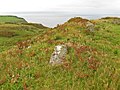
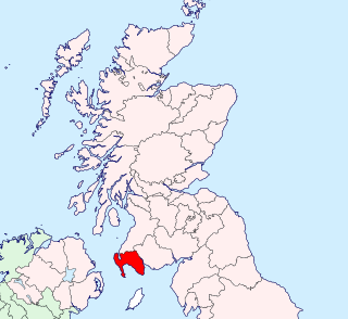
The Rhins of Galloway, otherwise known as the Rhins of Wigtownshire, is a hammer-head peninsula in Dumfries and Galloway, Scotland. Stretching more than 25 miles from north to south, its southern tip is the Mull of Galloway, the southernmost point of Scotland.

<span class="mw-page-title-main">Portpatrick</span> Human settlement in Scotland

Portpatrick is a village and civil parish in the historical county of Wigtownshire, Dumfries and Galloway, Scotland. It is located on the west coast of the Rhins of Galloway. The parish is about 4+12 miles (7 km) in length and 4 miles (6 km) in breadth, covering 9,300 acres (3,800 ha).

Drummore (drum-ORE; is the southernmost village in Scotland, located at the southern end of the Rhins of Galloway in Dumfries and Galloway: it has two satellite clachans, called Kirkmaiden and Damnaglaur.

Wincobank (hill fort)

Wincobank is an Iron Age hill fort near Wincobank in Sheffield, England.

Ardwell is a village in the Scottish unitary council area of Dumfries and Galloway. It lies on the shores of Luce Bay in the southern part of the Rhins of Galloway. The A716 road to Drummore or the Mull of Galloway passes through the village. The only other street is Ardwell Park, a street of new houses.

Yarnbury Castle Site of a multiphase, multivallate Iron Age hillfort in Wiltshire, England

Yarnbury Castle is the site of a multiphase, multivallate Iron Age hillfort near the village of Steeple Langford, Wiltshire, England. The site covers an area of 28.5 acres (11.5 ha), and was extensively surveyed and investigated by the Royal Commission on the Historical Monuments of England in 1991, with finds of Iron Age and Romano-British pottery, Iron Age and Roman coins, and burials of human remains. There is much evidence of prolonged and extensive settlement of the site, including evidence of around 130 structures of various sizes, most probably representing a mix of round houses, pits, and other features. It was designated as a scheduled monument in 1925.

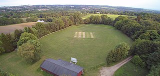
Sorbie is a small village in Wigtownshire, Machars, within the Administration area of Dumfries and Galloway Council, Scotland.

Glasserton is a civil parish in Dumfries and Galloway, south-west Scotland. It is on the Machars peninsula, in the traditional county of Wigtownshire. The parish is about 8 miles (13 km) in length, varying in breadth from 1 to 3 miles, and contains 13,477 acres (54.54 km2).

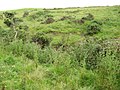
Stoneykirk is an area and a village in the heart of the Rhins of Galloway, Wigtownshire, in the administrative council area of Dumfries and Galloway, Scotland nearly ten miles in length and three and a half miles in breadth, bounded on the east by the bay of Luce, and on the west by the Irish Channel, 5 miles (8.0 km) south of Stranraer.

Bury Camp Iron Age hillfort in Wiltshire, England

Bury Camp is the site of an Iron Age multivallate hillfort in north-west Wiltshire, England. It occupies a triangular promontory of Colerne Down, in the north of Colerne parish, at the southern edge of the Cotswold Hills between two spurs of a river valley. The enclosed area of approximately 9.2ha is surrounded by a ditch 4m wide and up to 1m deep, and an outer rampart up to 1.5m high on the east and northwestern sides and up to 2m high on the southwestern side, across the neck of the promontory.

Cholesbury Camp Iron Age hillfort in Buckinghamshire, England

Cholesbury Camp is a large and well-preserved Iron Age hill fort on the northern edge of the village of Cholesbury in Buckinghamshire, England. It is roughly oval-shaped and covers an area, including ramparts, of 15 acres (6.1 ha), and measures approximately 310 m (1,020 ft) north-east to south-west by 230 m (750 ft) north-west to south-east. The interior is a fairly level plateau which has been in agricultural use since the medieval period. The hill fort is now a scheduled ancient monument.

Grovely Castle Iron Age hillfort in Wiltshire, England

Grovely Castle is the site of an Iron Age univallate hill fort in the parish of Steeple Langford, in Wiltshire. The remaining ramparts stand approximately 3.2 m (10 ft) high, with 1.5 m (4.9 ft) deep ditches, although ploughing has damaged the earthworks in some parts of the site. Excavations have uncovered the remains of five human skeletons within the ramparts. Entrances are in the south-west and north-east corners of the hillfort. A circular enclosure of 35 to 40 m is evident in aerial photographs of the hillfort interior. There is also a later bank and ditch which runs through the hill-fort from south-west to north-east, and is probably part of an extensive surrounding Celtic field system.

<span class="mw-page-title-main">Promontory forts of Cornwall</span>

Cornish promontory forts, commonly known in Cornwall as cliff castles, are coastal equivalents of the hill forts and Cornish "rounds" found on Cornish hilltops and slopes. Similar coastal forts are found on the north–west European seaboard, in Normandy, Brittany and around the coastlines of the British Isles, especially in Wales, Scotland and Ireland. Many are known in southwest England, particularly in Cornwall and its neighbouring county, Devon. Two have been identified immediately west of Cornwall, in the Isles of Scilly.

Castle Rings, Wiltshire Iron Age hillfort in Wiltshire, England

Castle Rings is a univallate hill fort in the parish of Donhead St Mary in Wiltshire in England. The fort is a Scheduled Ancient Monument, with a list entry identification number of 1005698. Castle Rings has been dated to the Iron Age and is situated at an altitude of 228 metres (748 ft) upon Upper Greensand sandstone beds. The main bulk of the fort enclosure lies within the boundaries of Donhead St Mary parish but some of the outlying earthworks are situated in the neighbouring Sedgehill and Semley parish. In the mid-1980s a metal detectorist unearthed a hoard of stater coins of the Durotriges tribe within the hill fort.

Doune of Relugas

The Doune of Relugas is a hill fort located 9.25 kilometres (5.75 mi) south south west of Forres in Moray, Scotland. It is situated on a rocky knoll rising to approximately 400 feet (120 m) above ordnance datum and forming the south east part of the promontory at the confluence of the River Findhorn and the River Divie. The site commands an uninterrupted view of the valley of the Findhorn as far as Culbin Sands, 9 miles to the north on the shore of the Moray Firth.

Knock of Alves

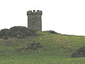
The Knock of Alves is a small wooded hill that lies 3 miles (4.8 km) to the west of Elgin in Moray, Scotland, rising to 335 feet (102 m) above ordnance datum. Its summit is marked by York Tower, a 3-storey octagonal folly erected in 1827 to commemorate Prince Frederick, the Duke of York; and the Forteath Mausoleum, built in 1850 as the burial place of 7 members of the Forteath family of the nearby house of Newton.

The Bulwarks, Porthkerry

The Bulwarks, Porthkerry is a promontory fort in Rhoose, Vale of Glamorgan, on the southern coast of Wales overlooking the Bristol Channel. It probably dates to the Iron Age and continued to be occupied during the Roman period in Britain. The ramparts and ditches along the west side are well preserved, but the fortifications are heavily overgrown.

<span class="mw-page-title-main">Beacon Hill, West Sussex</span>

Beacon Hill, also known as Harting Beacon, is a hillfort on the South Downs, in the county of West Sussex in southern England. The hillfort is located in the parish of Elsted and Treyford, in Chichester District. It is a Scheduled Ancient Monument with a list entry identification number of 1015915. The hilltop enclosure is dated to the Late Bronze Age, from the 8th to 6th centuries BC. The hillfort defences were renewed during the Late Iron Age.

<span class="mw-page-title-main">South Weald Camp</span>

South Weald Camp was a hillfort based in South Weald, Brentwood, Essex, England. Roughly circular in plan, the fort covered 2.8 hectares, with a suggested construction date in the late Iron Age, from the 1st century BC to the 1st century AD. The location is associated in this period with the Catuvellauni and the Trinovantes.

References

  1. 1 2 MacQueen (2002) pp 50 & 51.
  2. Nicolaisen 1976 pp 109-110
  3. 1 2 Statistical Account of Scotland , vol 5, page 430; republished 1983
  4. See "Copyright and Intellectual Property Cover Sheet". Archived from the original on 9 February 2012. Retrieved 18 September 2012., accessed 26 January 2008
  5. Neighbour, T. (2001). "Resistivity imaging of the linear earthworks at the Mull of Galloway, Dumfries and Galloway". Archaeological Prospection. 8 (3): 157–162. doi:10.1002/arp.163. S2CID   140715149.
  6. "Castle Clanyard". Archived from the original on 3 February 2014. Retrieved 21 November 2012.
  7. Kirkmaiden Church bell, AD1534 "Archaeological Sites". Archived from the original on 1 February 2014. Retrieved 21 November 2012.
  8. "Killumpha Tower | Canmore". Archived from the original on 26 October 2014. Retrieved 7 December 2012.
  9. Statistical Account of Scotland , vol 5, page xxviii; republished 1983
  10. There is a Flixton in Lancashire, Yorkshire and Suffolk, but none in Scotland; it is not clear where Adair was settled
  11. Statistical Account of Scotland, vol 5, page 432; republished 1983
  12. Archaeological and Historical Collections relating to Ayrshire and Galloway. vol.V. pp.62-73 https://archive.org/stream/cu31924092901606#page/n115/mode/2up
  13. "Proceedings of the Society of Antiquaries of Scotland". 1851 via Internet Archive.
  14. "Kirkmaiden Natural History Group". Archived from the original on 1 June 2013. Retrieved 12 October 2012.
  15. "History of the Lands and Their Owners in Galloway. With Historical Sketches of the District". A. Gardner. 1906.