
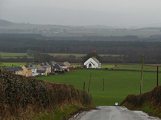
Keir is a civil parish, containing the small village of Keir Mill, in Dumfries and Galloway, Scotland, one mile south of Penpont. It was founded in the late eighteenth century.
Keir is a civil parish, containing the small village of Keir Mill, in Dumfries and Galloway, Scotland, one mile south of Penpont. It was founded in the late eighteenth century.
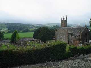
The village was the birthplace of Kirkpatrick Macmillan, the inventor of the bicycle. [1] A plaque on his home, Courthill Smithy, commemorates this. He is buried in the parish church.
The church itself is in the Gothic style, of Capenoch ashlar, and was built from 1813 to 1815 by architect William Burn. In 1880 a vestry was added by James Barbour. [2]
The other notable building in the village is the Mill, built in 1771. [3]

Kirkcudbrightshire, or the County of Kirkcudbright or the Stewartry of Kirkcudbright is one of the historic counties of Scotland, covering an area in the south-west of the country. Until 1975, Kirkcudbrightshire was an administrative county used for local government. Since 1975, the area has formed part of Dumfries and Galloway for local government purposes. Kirkcudbrightshire continues to be used as a registration county for land registration. A lower-tier district called Stewartry covered the majority of the historic county from 1975 to 1996. The area of Stewartry district is still used as a lieutenancy area. Dumfries and Galloway Council also has a Stewartry area committee.

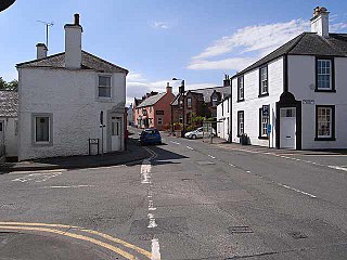
Penpont is a village about 2 miles (3 km) west of Thornhill in Dumfriesshire, in the Dumfries and Galloway region of Scotland. It is near the confluence of the Shinnel Water and Scaur Water rivers in the foothills of the Southern Uplands. It has a population of about 400 people.

Closeburn Castle is a privately owned tower house, probably of the 14th century, but possibly older, and is one of the oldest continually inhabited houses in Scotland. The castle is located 1 km east of the village of Closeburn, in the historical county of Dumfriesshire, 2 km south-east of Thornhill, in Dumfries and Galloway, Scotland.

Twynholm is a village in Scotland. It is located 2+1⁄4 miles (3.6 km) north-northwest of Kirkcudbright and 4+1⁄2 miles (7.2 km) east of Gatehouse of Fleet on the main A75 trunk road. It is in the historic county of Kirkcudbrightshire, Dumfries and Galloway.
Sorbie is a small village in Wigtownshire, Machars, within the Administration area of Dumfries and Galloway Council, Scotland.

Middlebie is a hamlet and parish in the historic county of Dumfriesshire in Dumfries and Galloway, south-west Scotland. It is approximately 2 miles (3.2 km) east of Ecclefechan, and 6 miles (9.7 km) north-east of Annan, on the banks of the Middlebie Burn.

Kirkpatrick Durham is a village and parish in the historical county of Kirkcudbrightshire, Dumfries and Galloway, south-west Scotland. It is located 6 miles (9.7 km) north of Castle Douglas.

Closeburn is a village and civil parish in Dumfries and Galloway, Scotland. The village is on the A76 road 2+1⁄2 miles (4 km) south of Thornhill. In the 2001 census, Closeburn had a population of 1,119. Closeburn is recorded as Killosbern in 1185. The first element of the name is Gaelic cill 'cell or church'. The second element is a saint's name, but none has definitely been identified.

Torthorwald is a village and civil parish in Dumfries and Galloway, south-west Scotland. It is located 6 kilometres (3.7 mi) east of Dumfries on the A709 road to Lochmaben. The area was the property of the de Torthorwald family until the end of the 13th century, when the estate passed by marriage to the Kirkpatricks. In 1418, William de Carleil married the Kirkpatrick heiress. He may have been the builder of Torthorwald Castle, which was erected around this time, possibly on top of an earlier a motte. Torthorwald was erected as a burgh of barony in 1473. Torthorwald Castle was occupied until 1715; only two of its walls still stand, to a height of around 18 metres (59 ft).

Kirkpatrick-Fleming is a village and civil parish in Dumfries and Galloway, south-west Scotland.

Troqueer is a former village and a parish in the historic county of Kirkcudbrightshire in Dumfries and Galloway on the west side of the River Nith. The eastern-side was merged with Dumfries to the east in 1929, and today eastern Troqueer is a suburb of Dumfries.

Kirkgunȝeon is a village and civil parish in Dumfries and Galloway, south west Scotland. The village is 10.4 miles (16.7 km) south west of Dumfries and 4.1 miles (6.6 km) north east of Dalbeattie. The civil parish is in the former county of Kirkcudbrightshire, and is bounded by the parishes Lochrutton to the north, Urr to the west, Colvend and Southwick to the south and New Abbey to the east.

Dalgarnock, Dalgarno, Dalgarnoc was an ancient parish and a once considerable sized village in the Nithsdale area of Dumfries and Galloway, Scotland, south of Sanquhar and north of Dumfries that enclosed the parish of Closeburn but was annexed to Closeburn in 1606 following the Reformation, separated again in 1648 and finally re-united in 1697, as part of the process that established the Presbyterian Church of Scotland. It was a burgh of regality bordering the River Nith and Cample Water and held a popular market-tryst or fair from medieval times until 1601 when the Earl of Queensberry had them transferred to Thornhill, commemorated in song by Robert Burns, shortly before its demise and now only a remote churchyard remains at a once busy site.
Mouswald is a rural village slightly east of Dumfries in south-west Scotland. It lies on the B724 south of the A75. The site views southward over the Solway Firth.


55°13′08″N3°47′42″W / 55.219°N 3.795°W
| Authority control: National |
|---|
| | This Dumfries and Galloway location article is a stub. You can help Wikipedia by expanding it. |