
Dumfries and Galloway is one of the 32 unitary council areas of Scotland, located in the western part of the Southern Uplands. It is bordered by East Ayrshire, South Ayrshire, and South Lanarkshire to the north; Scottish Borders to the north-east; the English ceremonial county of Cumbria, the Solway Firth, and the Irish Sea to the south, and the North Channel to the west. The administrative centre and largest settlement is the town of Dumfries. The second largest town is Stranraer, located 76 miles (122 km) to the west of Dumfries on the North Channel coast.
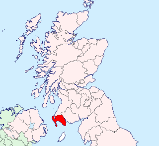
Kirkcudbrightshire, or the County of Kirkcudbright or the Stewartry of Kirkcudbright is one of the historic counties of Scotland, covering an area in the south-west of the country. Until 1975, Kirkcudbrightshire was an administrative county used for local government. Since 1975, the area has formed part of Dumfries and Galloway for local government purposes. Kirkcudbrightshire continues to be used as a registration county for land registration. A lower-tier district called Stewartry covered the majority of the historic county from 1975 to 1996. The area of Stewartry district is still used as a lieutenancy area. Dumfries and Galloway Council also has a Stewartry area committee.
Wigtownshire or the County of Wigtown is one of the historic counties of Scotland, covering an area in the south-west of the country. Until 1975, Wigtownshire was an administrative county used for local government. Since 1975 the area has formed part of Dumfries and Galloway for local government purposes. Wigtownshire continues to be used as a territory for land registration, being a registration county. The historic county is all within the slightly larger Wigtown Area, which is one of the lieutenancy areas of Scotland and was used in local government as the Wigtown District from 1975 to 1996.

Annandale and Eskdale is a committee area in Dumfries and Galloway, Scotland. It covers the areas of Annandale and Eskdale, the straths of the River Annan and the River Esk respectively. From 1975 until 1996 it was a local government district.

Nithsdale, also known as Strathnith, Stranith or Stranit, is the strath or dale of the River Nith in southern Scotland. Nithsdale was one of the medieval provinces of Scotland. The provinces gradually lost their administrative importance to the shires created from the twelfth century, with Nithsdale forming part of Dumfriesshire. A Nithsdale district covering a similar area to the medieval province was created in 1975, based in the area's main town of Dumfries. The district was abolished in 1996, since when the area has been directly administered by Dumfries and Galloway Council.
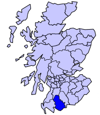
The Stewartry was a local government district from 1975 until 1996 within the Dumfries and Galloway region in south-west Scotland. Under the name The Stewartry of Kirkcudbright the area of the former district is still used as a lieutenancy area. Dumfries and Galloway Council has a Stewartry area committee which approximately covers the same area, subject to some adjustments where ward boundaries no longer follow the pre-1996 district boundary. The Stewartry covers the majority of the historic county of Kirkcudbrightshire, and derives its name from the county's alternative name of "The Stewartry of Kirkcudbright".
This is a list of people who have served as Lord-Lieutenant of Kirkcudbright, part of the Dumfries and Galloway council area of south-west Scotland. Prior to 1975 the lieutenancy corresponded to the historic county of Kirkcudbrightshire. Since 1975 the lieutenancy area has been the slightly smaller Stewartry district, corresponding to the local government district of Stewartry established in 1975 and abolished in 1996. From 1975 until 1996 the title was the "Lord-Lieutenant for Dumfries and Galloway Region ". In 1996 the title was changed to "Lord-Lieutenant for the Stewartry of Kirkcudbright".
This is a list of people who have served as Lord Lieutenant of Wigtown, part of the Dumfries and Galloway council area of south-west Scotland. Prior to 1975 the lieutenancy area corresponded to the historic county of Wigtownshire. Since 1975 the lieutenancy area has been the slightly larger Wigtown Area, covering the historic county plus the two parishes of Kirkmabreck and Minnigaff from Kirkcudbrightshire.

New Abbey is a village in the historical county of Kirkcudbrightshire in Dumfries and Galloway, Scotland. It is 6 miles (10 km) south of Dumfries. The summit of the prominent hill Criffel is 2.5 miles (4.0 km) to the south.

Terregles is a village and civil parish near Dumfries, in Dumfries and Galloway, Scotland. It lies in the former county of Kirkcudbrightshire.

Wigtown is a lieutenancy area in south-west Scotland and a committee area of Dumfries and Galloway Council. From 1975 until 1996 it was also a local government district. It closely resembles the historic county of Wigtownshire, covering the whole area of that county but also including the two parishes of Kirkmabreck and Minnigaff from the historic county of Kirkcudbrightshire.

Arbigland in the historical county of Kirkcudbrightshire, Dumfries and Galloway, Scotland, lies on the coast of the Solway Firth, to the south-east of Kirkbean. It is the birthplace of John Paul Jones, the United States' first well-known naval commander in the American Revolutionary War. There is a birthplace museum in the cottage where he was born, donated by the Blackett family to the John Paul Jones Museum Trust in 1997. The Arbigland Estate also has a number of seaside holiday cottages.
John Paul Jones (1747–1792) was a Scottish-American naval commander during the American Revolutionary War.
Minnigaff is a village and civil parish in the historic county of Kirkcudbrightshire in Dumfries and Galloway, Scotland. Lead was discovered there in 1763 and mined about two miles from the village until 1839.

The John Paul Jones Cottage Museum is located on the Arbigland Estate near Kirkbean in the historical county of Kirkcudbrightshire, Dumfries and Galloway, Scotland. The cottage is where John Paul Jones, hero of the American Revolutionary War and founder of the United States Navy, was born in 1747. Jones' father was a gardener for the estate.

Troqueer is a former village and a parish in the historic county of Kirkcudbrightshire in Dumfries and Galloway on the west side of the River Nith. The eastern-side was merged with Dumfries to the east in 1929, and today eastern Troqueer is a suburb of Dumfries.

Colvend and Southwick is a community council area and civil parish within the Stewartry area of Dumfries and Galloway, Scotland. It is also part of the Church of Scotland parish of Colvend, Southwick and Kirkbean. It is in the historic county of Kirkcudbrightshire.
Helen Craik was a Scottish poet and novelist. She has been known as a correspondent of the Scottish poet Robert Burns, whom she praised for being a "native genius, gay, unique and strong" in an introductory poem she inscribed on his Glenriddell Manuscripts. More recent scholarship has focused on her own life and writings, rather than her link to Burns.

Kirkgunȝeon is a village and civil parish in Dumfries and Galloway, south west Scotland. The village is 10.4 miles (16.7 km) south west of Dumfries and 4.1 miles (6.6 km) north east of Dalbeattie. The civil parish is in the former county of Kirkcudbrightshire, and is bounded by the parishes Lochrutton to the north, Urr to the west, Colvend and Southwick to the south and New Abbey to the east.

Kirkmabreck is a civil parish in the historic county of Kirkcudbrightshire in the Dumfries and Galloway council area, Scotland.

