
A watermill or water mill is a mill that uses hydropower. It is a structure that uses a water wheel or water turbine to drive a mechanical process such as milling (grinding), rolling, or hammering. Such processes are needed in the production of many material goods, including flour, lumber, paper, textiles, and many metal products. These watermills may comprise gristmills, sawmills, paper mills, textile mills, hammermills, trip hammering mills, rolling mills, wire drawing mills.

The River Don is a river in South Yorkshire and the East Riding of Yorkshire, England. It rises in the Pennines, west of Dunford Bridge, and flows for 69 miles (111 km) eastwards, through the Don Valley, via Penistone, Sheffield, Rotherham, Mexborough, Conisbrough, Doncaster and Stainforth. It originally joined the Trent, but was re-engineered by Cornelius Vermuyden as the Dutch River in the 1620s, and now joins the River Ouse at Goole. Don Valley is a UK parliamentary constituency near the Doncaster stretch of the river.

The River Sheaf in Sheffield, South Yorkshire, England, flows northwards, past Dore, through Abbeydale and north of Heeley. It then passes into a culvert, through which it flows under the centre of Sheffield before joining the River Don. This lower section of the River Sheaf, together with the River Don between the Blonk Street and Lady's Bridges, formed two sides of the boundary of Sheffield Castle.
The Porter Brook is a river which flows through the City of Sheffield, England, descending over 1,000 feet (300 m) from its source on Burbage Moor to the west of the city to its mouth where it joins the River Sheaf in a culvert beneath Sheffield railway station. Like the other rivers in Sheffield, its steep gradient made it ideal for powering water mills and works associated with the metalworking and cutlery industries, and around 20 dams were constructed over the centuries to facilitate this. At its lower end, it is extensively culverted, but parts of it are gradually being restored to open channels, as part of a daylighting scheme for the city.

Low Bradfield is a village within the civil parish of Bradfield in South Yorkshire, England. It is situated within the boundary of the city of Sheffield in the upper part of the Loxley Valley, 6¼ miles west-northwest of the city centre and just inside the northeast boundary of the Peak District National Park. Low Bradfield and the surrounding area is noted for its attractive countryside which draws many visitors from the more urban parts of Sheffield. At weekends the village can become quite crowded, especially when there is a match on the village cricket pitch. Low Bradfield which stands in the shadow of Agden Reservoir has a sister village High Bradfield which is located at a higher altitude, ½ mile to the northeast. The two villages are joined by the steep Woodfall Lane.

The Great Sheffield Flood was a flood that devastated parts of Sheffield, England, on 11 March 1864, when the Dale Dyke Dam broke as its reservoir was being filled for the first time. At least 240 people died and more than 600 houses were damaged or destroyed by the flood. The immediate cause was a crack in the embankment, the cause of which was never determined. The dam's failure led to reforms in engineering practice, setting standards on specifics that needed to be met when constructing such large-scale structures. The dam was rebuilt in 1875.

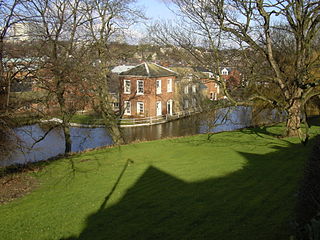
The Kelham Island Museum is an industrial museum on Alma Street, alongside the River Don, in the centre of Sheffield, England. It was opened in 1982.
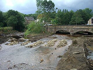
The River Loxley is a river in the City of Sheffield, South Yorkshire, England. Its source is a series of streams which rise some 10 miles (16 km) to the north-west of Sheffield on Bradfield Moors, flowing through Bradfield Dale to converge at Low Bradfield. It flows easterly through Damflask Reservoir and is joined by Storrs Brook at Storrs, near Stannington, and the River Rivelin at Malin Bridge, before flowing into the River Don at Owlerton, in Hillsborough. The Loxley valley provided the initial course of the Great Sheffield Flood, which happened after the Dale Dyke Dam collapsed shortly before its completion in March 1864.

The River Rivelin is a river in Sheffield, South Yorkshire, England.
Malin Bridge is a suburb of the city of Sheffield, England. It is located at grid reference SK325893 and stands 2½ miles north-west of the city centre where the rivers Loxley and Rivelin meet. Malin Bridge is only a small district centred on the road bridge over the River Loxley which carries the B6076 road to Stannington ; it is surrounded by the suburbs of Hillsborough, Wisewood, Walkley and Stannington.

The River Eden is a tributary of the River Medway in south east England. It rises at the foot of the North Downs escarpment near Titsey in Surrey and runs initially southwards through Oxted before turning eastwards to enter Kent. After flowing through Edenbridge and passing Hever Castle, the Eden meets the Medway at Penshurst.

Abbeydale Industrial Hamlet is an industrial museum in the south of the City of Sheffield, England. The museum forms part of a former steel-working site on the River Sheaf, with a history going back to at least the 13th century. It consists of a number of dwellings and workshops that were formerly the Abbeydale Works—a scythe-making plant that was in operation until the 1930s—and is a remarkably complete example of a 19th-century works. The works are atypical in that much of the production process was completed on the same site. A more typical example of water-powered works in the area can be found at Shepherd Wheel.

Loxley is a village and a suburb of the city of Sheffield, England. It is a long linear community which stretches by the side of the River Loxley and along the B6077 for almost 2.5 miles (4 km). Loxley extends from its borders with the suburbs of Malin Bridge and Wisewood westward to the hamlet of Stacey Bank near Damflask Reservoir. The centre of the suburb is situated at the junction of Rodney Hill and Loxley Road where the old village green stands and this is located 3 miles (5 km) north west of Sheffield city centre. The suburb falls within the Stannington ward of the City of Sheffield.

The Old Hay Brook is a small river in Sheffield, South Yorkshire, England. It is formed from the Redcar Brook, Blacka Dike and another stream, which rise on moors to the south of Sheffield, and is joined by Needham's Dyke near Totley Grange. At Totley Rise it joins Totley Brook, to become the River Sheaf. Water from the river was used to power mills processing lead, corn and paper from at least the 17th century, which were later used for grinding scythes as the Sheffield metal industry expanded. All the mills were defunct by 1900, although some remnants including weirs and dams are still visible.
The Medway and its tributaries and sub-tributaries have been used for over 1,150 years as a source of power. There are over two hundred sites where the use of water power is known. These uses included corn milling, fulling, paper making, iron smelting, pumping water, making gunpowder, vegetable oil extraction, and electricity generation. Today, there is just one watermill working for trade. Those that remain have mostly been converted. Such conversions include a garage, dwellings, restaurants, museums and a wedding venue. Some watermills are mere derelict shells, lower walls or lesser remains. Of the majority, there is nothing to be seen. A large number of tributaries feed into the River Medway. The tributaries that powered watermills will be described in the order that they feed in. The mills are described in order from source to mouth. Left bank and right bank are referred to as though the reader is facing downstream. This article covers the tributaries that feed in above Penshurst.
The Medway and its tributaries and sub-tributaries have been used for over 1,150 years as a source of power. There are over two hundred sites where the use of water power is known. These uses included corn milling, fulling, paper making, iron smelting, pumping water, making gunpowder, vegetable oil extraction, and electricity generation. Today, there is just one watermill working for trade. Those that remain have mostly been converted. Such conversions include a garage, dwellings, restaurants, museums and a wedding venue. Some watermills are mere derelict shells, lower walls or lesser remains. Of the majority, there is nothing to be seen. A large number of tributaries feed into the River Medway. The tributaries that powered watermills will be described in the order that they feed in. The mills are described in order from source to mouth. Left bank and right bank are referred to as though the reader is facing downstream. This article covers the watermills on the tributaries that feed in below Penshurst and above Yalding.
Neepsend is a suburb of the city of Sheffield, it stands just 1 mile (1.6 km) north-west of the city centre. The main area of Neepsend covers the flood plain of the River Don from Lady's Bridge at the Wicker up to Hillfoot Bridge. The suburb falls within the Central Ward of the City. The adjacent district of Parkwood Springs is often regarded as part of the suburb.

Storrs is a hamlet within the boundaries of the City of Sheffield in England, it is situated 6.5 km west-northwest of the city centre. Storrs is located between the suburb of Stannington and the village of Dungworth in the civil parish of Bradfield at a height of 210 metres above sea level between the Loxley and Rivelin valleys. Although historically a farming settlement, water-powered milling on the Storrs Brook and small scale cutlery making has also taken place in the hamlet.

Sharrow Mills are a collection of industrial buildings in Sheffield, England, which have been used for the production of snuff by the firm of Wilsons of Sharrow since the mid 18th century. The mills stands on the Porter Brook in the Sharrow Vale area of the city, just off Ecclesall Road.

