Llangain

Last updated

Llangain
Capel Smyrna.JPG
Capel Smyrna, Llangain
Carmarthenshire UK location map.svg
Red pog.svg
Llangain
Location within Carmarthenshire
Population573 (2011 Census)
OS grid reference SN385155
Community
  • Llangain
Principal area
Preserved county
Country Wales
Sovereign state United Kingdom
Post town CARMARTHEN
Postcode district SA33
Dialling code 01267
Police Dyfed-Powys
Fire Mid and West Wales
Ambulance Welsh
UK Parliament
Senedd Cymru – Welsh Parliament
List of places
UK
Wales
Carmarthenshire
51°48′53″N4°20′40″W / 51.814733°N 4.344321°W / 51.814733; -4.344321

Llangain is a village [1] and community in Carmarthenshire, in the south-west of Wales. Located to the west of the River Towy, and south of the town of Carmarthen, the community contains three standing stones, and two chambered tombs as well as the ruins of 15th century great house, Castell Moel. In 2001 the community's population was recorded at 574, [2] decreasing slightly to 573 at the 2011 census. [3]

Contents

Location

Situated near the bank of the Afon Tywi, the parish extends from near Johnstown to Llansteffan in one direction and from Llangynog to the river in another and consists of very pleasant countryside with gentle hills reaching 350 ft/105m (Trig Point) and stretches of woodlands. The parish encloses an area of almost 3,000 acres (12 km2). Prehistory There are a few cromlechs or dolmens, the best examples being Meini Llwydion (Greystones) and Merlin's Quoits. They were communal burial places for family groups dating back to the Neolithic period (c.3000 BC).

The community is bordered by the communities of: Carmarthen; Llandyfaelog; Llansteffan; and Llangynog, all being in Carmarthenshire.

Education

In 1846 the only school was a Sunday School. Llangain Board School was built in 1875 and officially opened in 1876, and was in use until superseded by the new school in 1977, to which only about 30-35 children go. There was an after school club but it closed down because not enough children went.

Religion

The present church of St Cain was built in 1871. There is a tiled mural on either side of the altar in memory of the Gwyn family of Pilroath and Plas Cwrthir. An Elizabethan chalice is dated 1576.

Capel Smyrna, a congregational chapel, is a prominent landmark within the parish. Originally built in 1835, it was rebuilt in 1865 and restored in 1915. The white building provided stabling for horses during chapel services. The loft served as the vestry.

Notable buildings

Castell Moel (Green Castle) is a local landmark at the sharp bend on the B4312. The ruins of the impressive, late medieval residence still stand. It was never a castle but a residence built for the Reed family in the early 15th century and was in ruin in Elizabethan times. It is possible there had been some earthen fortification there at one time. Some believe this to be at Old Castle. Doubtless this would have been a motte and bailey. Until recent times ships used to lie at anchor below to off load onto lighter vessels for transport to Carmarthen.

Coedmor was built in 1968 for Mr and Mrs E.J.Williams, retired farmers of Penycoed. Coedmor Avenue is named in recognition of their ownership of the land and the family's continuing local connection.

Bwthyn-y-Felin is an old woollen mill which employed four full-time workers in its heyday. Llangain Mill closed in the 1940s.

Llwyndu mansion, a Grade II listed building, was built in the early 19th century. In 1821-1823 Captain Henry Harding lived there and it was afterwards the home of Frederick Philipps, JP. [4] In 1906 the owner was Charles Bankes Davies. It has an upper and lower lodge. The original name for the upper lodge The Beeches, was Chweched meaning Sixth, indicating the six lanes. The main mansion building was largely destroyed by fire in June 2015 with only the front and side elevations remaining.

Pilroath mansion is situated at the southern end of the parish above the confluence of the Rhoth Brook and the Afon Tywi. In 1902 the property was purchased by T J Harries, Esq. who built the present mansion. The property was occupied by the Harries family for three generations and owned until 1994 by County Councillor Arthur Harries, in which year it was purchased by David Lyn, who converted the courtyard and outbuildings into a production base where films and TV programmes reflecting local life were made.

Fernhill, a small gentry house dating back to 1723 and listed as a grade II building for its architectural and cultural connections. [5] Famous as a frequent childhood holiday retreat of the world-renowned poet Dylan Thomas (1914–1953), it became immortalised in one of his best-known poems, Fern Hill. Fernhill is also known for its association with the notorious county hangman, Robert Rickets Evans who lived there at the turn of the 20th century. His daughter was heiress to a fortune. He imprisoned her in a cell in the courtyard (which can still be seen today) to gain her fortune, but her lover helped her to escape, according to folklore. The story has been confirmed in more recent research, which has also described Thomas' stays at Fernhill and the extent of his family connections in the Llangain area. [6] [7]

Pantydderwen was a small cottage originally and once housed the Post Office and local sweet shop. It became a public house c.1979. The golf course opened in 1993.

Pantyrathro mansion was built by James Richards in the early 19th century. It was developed as a direct result of selling local milk products to London with the coming of the railway to Carmarthen. It became a local hotel in 1970.

Related Research Articles

<span class="mw-page-title-main">Carmarthenshire</span> County in Wales

Carmarthenshire is a county in the south-west of Wales. The three largest towns are Llanelli, Carmarthen and Ammanford. Carmarthen is the county town and administrative centre. The county is known as the "Garden of Wales" and is also home to the National Botanic Garden of Wales.

<span class="mw-page-title-main">Carmarthen</span> County town of Carmarthenshire, Wales

Carmarthen is the county town of Carmarthenshire and a community in Wales, lying on the River Towy 8 miles (13 km) north of its estuary in Carmarthen Bay. The population was 14,185 in 2011, down from 15,854 in 2001, but gauged at 16,285 in 2019. It has a claim to be the oldest town in Wales – Old Carmarthen and New Carmarthen became one borough in 1546. It was the most populous borough in Wales in the 16th–18th centuries, described by William Camden as "chief citie of the country". Growth stagnated by the mid-19th century as new settlements developed in the South Wales Coalfield.

<span class="mw-page-title-main">Aberaeron</span> Town in Ceredigion, Wales

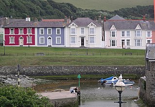
Aberaeron, previously anglicised as Aberayron, is a town, community and electoral ward in Ceredigion, Wales. Located on the coast between Aberystwyth and Cardigan, its resident population was 1,274 in the 2021 census.

<span class="mw-page-title-main">Kidwelly</span> Town in Wales

Kidwelly is a town and community in Carmarthenshire, southwest Wales, approximately 7 miles (11 km) northwest of the most populous town in the county, Llanelli. In the 2001 census the community of Kidwelly returned a population of 3,289, increasing to 3,523 at the 2011 Census.

<span class="mw-page-title-main">Laugharne</span> Town in Carmarthenshire, Wales

Laugharne is a town on the south coast of Carmarthenshire, Wales, lying on the estuary of the River Tâf.

<span class="mw-page-title-main">Ferryside</span> Village in Carmarthenshire, Wales

Ferryside is a village in the community of St Ishmael, Carmarthenshire, Wales. It is 8.5 miles (13.7 km) south of Carmarthen near the mouth of the River Tywi. Originally a ferry crossing, then becoming a fishing village, it has developed as a holiday and retirement area. The village has its own lifeboat station and was the first village in the UK to switch from analogue to digital television. The 2011 census showed the village to have 846 residents.

<span class="mw-page-title-main">Llansteffan</span> Village and community in Carmarthenshire, Wales

Llansteffan, is a village and community situated on the south coast of Carmarthenshire, Wales, lying on the estuary of the River Tywi, 7 miles (11 km) south of Carmarthen.

<span class="mw-page-title-main">Llansteffan Castle</span> Castle in Carmarthenshire, Wales

<span class="mw-page-title-main">Laugharne Castle</span> Building in Carmarthenshire, Wales

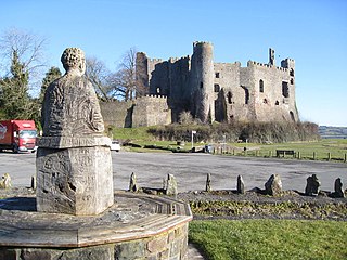
Laugharne Castle is in Laugharne, Carmarthenshire, Wales. The castle, located on the estuary of the River Tâf, was originally established in 1116. It was rebuilt as a Norman stronghold. There have been many alterations since then, including becoming a Tudor fortified manor house in the sixteenth century. It changed hands twice during the English Civil War, being eventually captured by Parliamentary forces in 1644.

<span class="mw-page-title-main">Dryslwyn Castle</span> Castle in Carmarthenshire, Wales

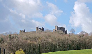
Dryslwyn Castle is a native Welsh castle, sited on a rocky hill roughly halfway between Llandeilo and Carmarthen in Wales. It stands on high ground overlooking the Tywi Valley with extensive views. It was built in about the 1220s by one of the princes of the kingdom of Deheubarth, and changed hands several times in the struggles between the Welsh and English over the ensuing centuries. It is considered one of the most important remaining structures built by a Welsh chieftain and is a Grade I listed building.

<span class="mw-page-title-main">Carmarthen West and South Pembrokeshire (Senedd constituency)</span> Constituency of the Senedd

Carmarthen West and South Pembrokeshire is a constituency of the Senedd. It elects one Member of the Senedd by the first past the post method of election. In addition, it is one of eight constituencies in the Mid and West Wales electoral region, which elects four additional members, in addition to eight constituency members, to produce a degree of proportional representation for the region as a whole.

<span class="mw-page-title-main">Llangunnor</span> Village and community in Carmarthenshire, Wales

Llangunnor is a village and community located in Carmarthenshire, Wales. It is the southern suburb of Carmarthen town and consists mainly of typical suburban housing which has expanded in recent years. It has a small shop, two chapels, a church and a Primary School. It is made up of the villages and hamlets of Nantycaws, Pensarn, Login and Pibwrlwyd.

<span class="mw-page-title-main">Llangynog, Carmarthenshire</span> Village and community in Carmarthenshire, Wales

Llangynog is a village and community located in Carmarthenshire, Wales, the main settlement of which was once called ‘Ebenezer’village. It is bordered by the communities of: Newchurch and Merthyr; Carmarthen; Llangain; Llansteffan; Laugharne Township; and St Clears, all being in Carmarthenshire. The population at the 2011 census was 492.

<span class="mw-page-title-main">Plas Llanstephan</span> Country house in Carmarthenshire, Wales

Plas Llanstephan is a mansion in the county of Carmarthenshire, Wales. It is set well back from the public road among pasture fields and is reached by a private driveway from the village of Llansteffan. Both the hall and the stable block are grade II listed buildings. Llansteffan Castle overlooks the house from the summit of a low hill to the southeast.

<span class="mw-page-title-main">Castell Moel</span> Manor house remains in Carmarthenshire, Wales

Castell Moel is the remains of a 16th-century fortified manor house in the community of Llangain in Carmarthenshire, Wales, and also a medieval motte about 600 yards (550 m) to the south of the manor house. The remains are approximately 2.5 miles (4.0 km) south-west Carmarthen and 0.8 miles (1.3 km) north-east of the village of Llangain. Three miles to the north-west is Carmarthen Castle, and five miles to the south-west is Llansteffan Castle.

<span class="mw-page-title-main">Llanybri</span> Village in Carmarthenshire, Wales

Llanybri is a rural farming village situated between the estuaries of the River Tywi and River Taf in Carmarthenshire, Wales. It is one of two villages with their own churches in the community of Llansteffan.

Carmarthen Rural District Council was a local authority in the central part of Carmarthenshire, Wales created in 1894. The first election to the authority was held in December 1894.

The first election to the Carmarthen Rural District Council in Carmarthenshire, Wales was held in December 1894. It was followed by the 1898 election. The successful candidates were also elected to the Carmarthen Board of Guardians. In rural parishes, many councillors were returned unopposed.

References

  1. H. Williams (2007) The Book of Llangain: From Farming Community to Residential Village, Halsgrove
  2. Davies, John; Jenkins, Nigel; Menna, Baines; Lynch, Peredur I., eds. (2008). The Welsh Academy Encyclopaedia of Wales. Cardiff: University of Wales Press. p. 492. ISBN   978-0-7083-1953-6.
  3. "Community population 2011" . Retrieved 16 April 2015.
  4. "Llwyn-du, Llangain". britishlistedbuildings.co.uk. Retrieved 27 May 2014.
  5. "Fern Hill, Llangain". britishlistedbuildings.co.uk. Retrieved 27 May 2014.
  6. D N Thomas (2003) "Dylan Thomas Remembered 1914-34, vol 1" Seren.
  7. D. N. Thomas (2014) A True Childhood: Dylan’s Peninsularity in Dylan Thomas: A Centenary Celebration ed. H. Ellis, Bloomsbury.