Linn County is a county located in the northern portion of the U.S. state of Missouri. As of the 2020 census, the population was 11,874. Its county seat is Linneus. The county was organized January 1, 1837, and named after U.S. Senator Lewis F. Linn of Missouri.

Cooper County is located in the central portion of the U.S. state of Missouri. As of the 2020 United States census, the population was 17,103. Its county seat is Boonville. The county was organized December 17, 1818, and named for Sarshell Cooper, a frontier settler who was killed by Native Americans near Arrow Rock in 1814. It is a part of the Columbia, Missouri metropolitan area.

Whitfield County is a county located in the northwestern part of the U.S. state of Georgia. As of the 2020 census shows a population of 102,864. The county seat is Dalton. The county was created on December 30, 1851, and named after George Whitefield, Methodist evangelist. The "e" was omitted to reflect the pronunciation of his name.

Paulding County is a county located in the northwestern part of the U.S. state of Georgia. Part of Metro Atlanta, it had an estimated population of 168,661 in 2020. The county seat is Dallas.

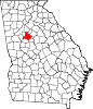
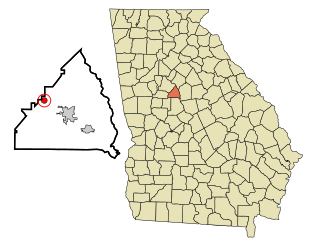
Gordon County is a county located in the northwestern part of the U.S. state of Georgia. As of the 2020 census, the population was 57,544. The county seat is Calhoun. Gordon County comprises the Calhoun, GA Micropolitan Statistical Area, which is included in the Atlanta–Athens-Clarke County–Sandy Springs, GA-AL CSA.

Catoosa County is a county located in the northwestern part of the U.S. state of Georgia. As of the 2020 census, the population was 67,872. The county seat is Ringgold. The county was created on December 5, 1853. The meaning of the Cherokee language name "Catoosa" is obscure: "Catoosa" may come from the Cherokee words gatusi or gatu'gitse.

Conoy Township is a township in northwestern Lancaster County, Pennsylvania, United States. At the 2020 census, the population was 3,373.
Jenkinsburg is a city in Butts County, Georgia, United States. The population was 370 at the 2010 census.
Summerville is a city and the county seat of Chattooga County, Georgia, United States. The population was 4,534 at the 2010 census.
Forest Park is a city in Clayton County, Georgia, United States. It is located approximately nine miles (14 km) south of Atlanta and is part of the Atlanta–Sandy Springs–Marietta Metropolitan Statistical Area. As of the 2020 census, the city had a population of 19,932.
Dawsonville is a city in and the county seat of Dawson County, Georgia, United States. The population was 2,536 at the 2010 census, up from 619 in 2000.

Redan is an unincorporated community and census-designated place (CDP) in DeKalb County, Georgia, United States. As of the 2020 census, the CDP had a total population of 31,749. It is a predominantly African American community in eastern DeKalb County, and is a suburb of Atlanta.
Blue Ridge is a city in Fannin County, Georgia, United States. As of the 2020 census, the city had a population of 1,253. The city is the county seat of Fannin County and the largest city in the county as well.

Union City is a city in Fulton County, Georgia, United States. The population was 26,830 at the 2020 census.

Buchanan is a city and the county seat of Haralson County, Georgia, United States. The population was 1,104 at the 2010 census, up from 941 at the 2000 census.

Hampton is a city in southwestern Henry County, Georgia, United States. The 2020 census was 8,368. As of the 2010 census, the city had a population of 6,987, up from 3,857 at the 2000 census. By 2018 the estimated population was 7,922. "Hampton" mailing addresses outside the city limits reach into rural parts of eastern Clayton County and northern Spalding County. It is a southeastern suburb in the Atlanta metropolitan area.

McDonough is a city in Henry County, Georgia, United States. It is part of the Atlanta metropolitan area. Its population was 22,084 at the 2010 census, up from 8,493 in 2000. The city is the county seat of Henry County. The unincorporated communities of Blacksville, Flippen, Kelleytown, and Ola are located near McDonough, and addresses in those communities have McDonough ZIP Codes.
Hiram is a city in Paulding County, Georgia, United States. As of the 2020 census, the population is 4,929.
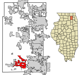
Sugar Grove is a village in Kane County, Illinois, United States. The population at the 2010 census was 8,997, and in 2018 the estimated population was 9,803.

Atwater is a city in Kandiyohi County, Minnesota, United States. The population was 1,124 at the 2020 census.