Related Research Articles
Cupar is a town, former royal burgh and parish in Fife, Scotland. It lies between Dundee and Glenrothes. According to a 2011 population estimate, Cupar had a population around 9,000, making it the ninth-largest settlement in Fife, and the civil parish a population of 11,183. It is the historic county town of Fife, although the council now sits at Glenrothes.

Kilmany is a village and parish in Fife, Scotland. It is located on the A92 between Auchtermuchty and the Tay Road Bridge. In 2001 it had a population of 75.
Saline is a village and parish in Fife, Scotland, situated 5 miles (8.0 km) to the north-west of Dunfermline. It lies in an elevated position on the western slopes of the Cleish Hills.
Dairsie, or Osnaburgh, is a village and parish in north-east Fife, Scotland. It is 3 miles (4.8 km) south-southwest of Leuchars Junction, and 3 miles (4.8 km) east-northeast of Cupar on the A91 Stirling to St Andrews road. The village grew out of two smaller settlements, and developed principally around the industry of weaving. Since the late twentieth century it has become a dormitory settlement for nearby towns.

Kemback is a village and parish in Fife, Scotland, located 2.5 miles (4.0 km) east of Cupar. The present village was developed in the 19th century to house those working the flax mills on the nearby Ceres Burn. From 1681 the minister for the parish was Alexander Edward, until 1689 when he was deprived as a non-juror. He went on to become an architect and landscape architect, working on schemes for Brechin Castle and Hamilton Palace.
Gauldry, locally sometimes The Gauldry, is a village in Fife, Scotland. It is located 3 kilometres (1.9 mi) southwest of Newport on Tay, 2 kilometres (1.2 mi) south-east of Balmerino, and 1 kilometre (0.62 mi) south of Bottomcraig.
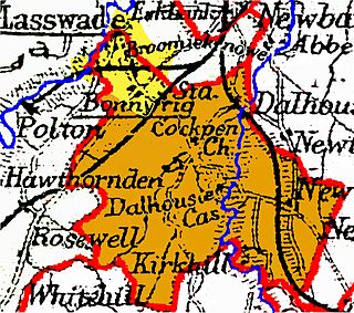
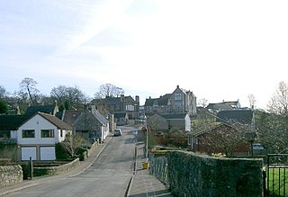
Cockpen is a parish in Midlothian, Scotland, containing at its north-west corner the town of Bonnyrigg, which lies two miles (3.2 km) south-west of Dalkeith. It is bounded on the west and north by the parish of Lasswade, on the east, by Newbattle and on the south by Carrington. It extends about three miles (4.8 km) from north to south and its greatest breadth is about 2+1⁄2 miles (4.0 km).

Scoonie is a settlement and parish in Fife, Scotland, the parish contains the town of Leven. It is bordered on the north by the parishes of Kettle and Ceres, on the east by the parish of Largo, on the south by the parishes of Markinch and Wemyss, and on the west by the parishes of Markinch and Kennoway. It extends about 4+1⁄2 miles north to south. Its width varies between 5⁄8 and 2+3⁄4 mi . The parish is on the coast of the Firth of Forth, with a coastline of about 1+1⁄2 mi (2.4 km) The area of the parish is 4,107 acres.
Largo is a parish in Fife, Scotland containing the villages of Upper Largo or Kirkton of Largo, Lower Largo and Lundin Links. It is bounded on the west by the parish of Scoonie, on the north by Ceres and on the east by the parishes of Newburn and Kilconquhar. It has a coastline of 2¾ miles along Largo bay. Inland it extends 3-4 ½ miles north from the south coast of Fife. Area 7,378 acres.

Nenthorn is a parish and hamlet in the south of the historic county of Berwickshire in the Scottish Borders area of Scotland. It is included in the Floors, Makerstoun, Nenthorn and Smailholm Community Council area, which also includes the parishes of Makerstoun and Smailholm. It was included in the former Roxburgh District of Borders Region, by the Local Government (Scotland) Act 1973, from 1975 to 1996.
Mertoun is a parish in the south-west of the historic county of Berwickshire in the Scottish Borders area of Scotland. Together with the parish of Maxton, Roxburghshire it forms the Maxton and Mertoun Community Council area. It was included in the former Ettrick and Lauderdale District of Borders Region, by the Local Government (Scotland) Act 1973, from 1975 to 1996.

Cranston is a parish of Midlothian, Scotland, lying 4+1⁄4 miles south-east of Dalkeith. It is bounded by the parishes of Inveresk and Ormiston on the east, by Crichton and Borthwick on the south ; and by Newbattle on the west and north. The River Tyne flows through the centre of the parish.
Moonzie is a small parish in Fife, Scotland, about 3 miles north-west of Cupar. It is bounded on the west by Creich, on the north by Kilmany, on the south-east by Cupar and on the south-west by Monimail.

Abdie is a parish in north-west Fife, Scotland, lying on the south shore of the Firth of Tay on the eastern outskirts of Newburgh, extending about 3 miles eastwards to the boundary of Dunbog parish, with which it is now united ecclesiastically and for the Community Council. It is also bounded by Collessie on the south and has a small border with the parish of Moonzie in the south-east.

Cameron is a parish in east Fife, Scotland, 3½ miles south-west of St Andrews.
Wemyss is a civil parish on the south coast of Fife, Scotland, lying on the Firth of Forth. It is bounded on the north-east by the parish of Scoonie and the south-west by the parish of Kirkcaldy and Dysart and its length from south-west to north-east is about 6 miles. Inland it is bounded by Markinch and its greatest breadth is 2+1⁄4 miles.
Kirkcaldy and Dysart is a civil parish on the south coast of Fife, Scotland, lying on the Firth of Forth, containing the towns of Kirkcaldy and Dysart and their hinterland. The civil parish was formed in December 1901 by an amalgamation of the parishes of Kirkcaldy, Dysart and Abbotshall, along with the portion of the parish of Kinghorn which lay within the burgh of Kirkcaldy. However the parish of Abbotshall was originally part of the parish of Kirkcaldy and had only been disjoined from it in 1650.

Largoward is a village in East Fife, Scotland, lying on the road from Leven to St Andrews in the Riggin o Fife, 4½ miles north-east of Lower Largo and 6½ miles south-west of St Andrews. It is an agricultural and former mining village, one of the three main villages of the civil parish of Kilconquhar, along with Colinsburgh and the village of Kilconquhar. Coal must have been worked for a considerable length of time in the district, as it is recorded that coal was driven annually from Falfield, just north-west of the village, to Falkland Palace for the use of King James VI.
Manor is a parish in Peeblesshire in the Scottish Borders, whose church lies on the west bank of Manor Water 3 miles south-west of Peebles.

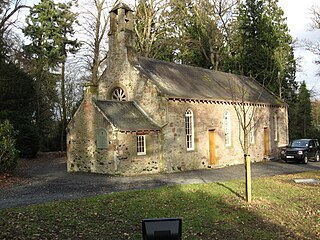
Balmerino Parish Church is a Church of Scotland parish church in Bottomcraig, Fife, Scotland. The church sits in the centre of the small village where it was built in 1811. It is situated across the road from the accompanying manse constructed in 1816.
References
- 1 2 Gazetteer of Scotland, publ, by W & AK Johnston, Edinburgh, 1937. Article on Logie. Places are presented alphabetically
- ↑ The New Statistical Account of Scotland by the Ministers of the Respective Parishes, Vol. IX Fife-Kinross. Publ. William Blackwood & Sons, Edinburgh, 1845; article on Logie
- 1 2 3 Ordnance Gazetteer of Scotland, by Francis Groome, 2nd edition 1896; article on Logie
- ↑ Census of Scotland 2011, Table KS101SC – Usually Resident Population, publ. by National Records of Scotland. Web site http://www.scotlandscensus.gov.uk/ retrieved March 2016. See “Standard Outputs”, Table KS101SC, Area type: Civil Parish 1930
- ↑ Fife Community Council web site showing Balmerino, Gauldry, Kilmany and Logie Community Council area, retrieved May 2016
- ↑ Web site of Historic Environment Scotland (former Royal Commission on the Ancient and Historical Monuments of Scotland), Logie Church http://canmore.org.uk/site/33242 retrieved Mat 2016
- ↑ University of St Andrews Library Archive Catalogue, Church of Scotland Kirk Session records Logie (search Logie), retrieved May 2016
- ↑ Calendar State Papers Scotland, vol. 10 (Edinburgh, 1936), pp. 750-3.
| Authority control databases: National |
|---|
56°22′20″N2°58′00″W / 56.37222°N 2.96667°W
| | This Fife location article is a stub. You can help Wikipedia by expanding it. |