London fare zones

Last updated

Route map of zonal system of the railway services directly managed by Transport for London. Stations only served by National Rail services are not shown in this map. London Underground Overground DLR Crossrail map zone.svg
Route map of zonal system of the railway services directly managed by Transport for London. Stations only served by National Rail services are not shown in this map.

Rail service fares in Greater London and the surrounding area are calculated in accordance with the London fare zones system managed by Transport for London. Within London, all London Underground, National Rail, London Overground, Elizabeth Line and Docklands Light Railway stations are assigned to six fare zones. [notes 1] Fare zone 1 covers the central area and fare zones 2, 3, 4, 5 and 6 form concentric rings around it. Some National Rail stations and almost all Transport for London served stations outside Greater London in the home counties of Buckinghamshire, Essex, Hertfordshire and Surrey are either included in fare zones 4, 5 or 6 or in extended zones beyond these. Transport for London fare zones are also known simply as zones or travelcard zones, referring to their use in calculating prices for the travelcards or pay-as-you-go caps. Before flat fares were introduced in 2004, fare zones were used on the London Buses network. London fare zones are also used for calculating the cost of single and return paper tickets, Oyster card pay-as-you-go fares and season tickets.

Contents

History

Before the introduction of fare zones, tickets for rail travel in Greater London were purchased on a 'point-to-point' basis between two stations, either as a single, return or season ticket; and were priced according to distance travelled. During the early 1980s the London Transport Executive of the Greater London Council made a series of revisions to fares which introduced the fare zones. The purpose of creating zones was to simplify fares, in order to speed up the process of buying tickets. On buses this became necessary as conductors were being eliminated in favour of the driver selling tickets, which was having an impact on the time it took passengers to board the bus and therefore on journey times.

The first zones were introduced on 4 October 1981. The whole of Greater London was divided into bus zones where flat fares applied. On the London Underground the area that is now zone 1 was divided into two overlapping areas called City and West End. On 21 March 1982 fares to all other London Underground stations were graduated at three mile intervals, effectively creating zones, although they were not named as such until 1983 when the Travelcard product was launched covering five numbered zones. City and West End became zone 1 and the rest of Greater London was within zones 2, 3, 4 and 5. Further products were launched using the zones: One Day Travelcard (1984), Capitalcard (1985), One Day Capitalcard (1986). In January 1991 Zone 5 was split to create a new Zone 6.

Principal fare zones

All of Greater London is within the six principal fare zones numbered 1 to 6. Inner zone 1 forms a roughly circular area and covers central London. Each of five outer zones forms a concentric ring around it. Zones 4, 5 and 6 additionally extend into parts of Essex, Hertfordshire and Surrey. List of boroughs in each zone:

Zone Inner London Outer London Outside London
1 Central London: City of London, Camden, Hackney, Islington, Kensington & Chelsea, Lambeth, Southwark, Tower Hamlets, Wandsworth and Westminster
2 Camden, Hackney, Hammersmith & Fulham, Islington, Kensington & Chelsea, Lambeth, Lewisham, Newham, Southwark, Tower Hamlets, Wandsworth and WestminsterBrent, Ealing, Greenwich, Hounslow
3 Camden, Hackney, Haringey, Islington, Lambeth, Lewisham, Newham, Southwark, WandsworthBarnet, Brent, Bromley, Croydon, Ealing, Greenwich, Hounslow, Merton, Richmond upon Thames, Waltham Forest
4 Lewisham, Haringey, NewhamBarking and Dagenham, Barnet, Bexley, Brent, Bromley, Croydon, Ealing, Enfield, Greenwich, Hounslow, Kingston upon Thames, Merton, Redbridge, Richmond upon Thames, Sutton, Waltham ForestEpping Forest (Essex)
5 Barking and Dagenham, Barnet, Bexley, Bromley, Croydon, Ealing, Enfield, Harrow, Hillingdon, Hounslow, Kingston upon Thames, Richmond upon Thames, Sutton, Waltham ForestEpping Forest (Essex), Epsom and Ewell (Surrey)
6 Bexley, Bromley, Croydon, Enfield, Harrow, Havering, Hillingdon, Hounslow, Kingston upon Thames, Richmond upon ThamesElmbridge (Surrey), Epping Forest (Essex), Epsom and Ewell (Surrey), Hertsmere (Hertfordshire), Reigate and Banstead (Surrey), Tandridge (Surrey), Three Rivers (Hertfordshire)

Ancillary zones

For some services outside Greater London, where fares are set by Transport for London, there are three additional zones 7, 8 and 9. They extend into Buckinghamshire, Essex and Hertfordshire to include all stations served by TfL services (except Shenfield, Watford Junction) and some Southeastern and Greater Anglia services that are outside Greater London. Unlike zones 2–6, they do not form complete rings around London.

As of January 2013, there were eight National Rail stations outside the nine numbered fare zones, where Oyster card pay as you go is permitted and fares are set by the train operating companies. They are located in Essex and Hertfordshire, and are organised into additional areas B, C, G and W. On maps, these stations are shown as being outside fare zones 1–9, but within the 'special fares' Oyster pay as you go area. [1]

In January 2016, the Oyster and contactless system was extended to Gatwick Airport in Crawley, West Sussex, and the stations down that line (Horley, Salfords, Earlswood, Redhill and Merstham). [2]

All stations accepting Oyster card but outside the publicised fare zones (except Stratford International) are put into secret zones, which are numbered 9 to 14, for the purpose of calculating caps. [3] In addition, there are stations which are further out accepting contactless payment cards but not Oyster cards. These stations do not belong to the zonal system, with caps applied on the basis of individual stations. [4]

Notes

  1. Stations can be assigned to one or two fare zones

Related Research Articles

<span class="mw-page-title-main">History of public transport authorities in London</span> Aspect of history

The history of public transport authorities in London details the various organisations that have been responsible for the public transport network in and around London, England - including buses, coaches, trams, trolleybuses, Docklands Light Railway, and the London Underground.

<span class="mw-page-title-main">Transport for London</span> English transport authority

Transport for London (TfL) is a local government body responsible for most of the transport network in London, United Kingdom.

<span class="mw-page-title-main">Oyster card</span> Payment method for public transport in London

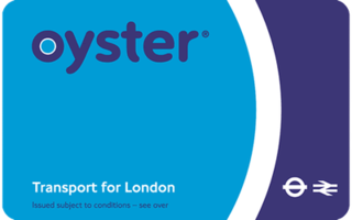
The Oyster card is a payment method for public transport in London in England, United Kingdom. A standard Oyster card is a blue credit-card-sized stored-value contactless smart card. It is promoted by Transport for London (TfL) and can be used on travel modes across London including London Buses, London Underground, the Docklands Light Railway (DLR), London Overground, Tramlink, some river boat services, and most National Rail services within the London fare zones. Since its introduction in June 2003, more than 86 million cards have been used.

<span class="mw-page-title-main">Travelcard</span> Ticket for the London local transport

The Travelcard is an inter-modal travel ticket for unlimited use on the London Underground, London Overground, Elizabeth line, Docklands Light Railway, London Trams, London Buses and National Rail services in the Greater London area. Travelcards can be purchased for a period of time varying from one day to a year, from Transport for London, National Rail and their agents. Depending on where it is purchased, and the length of validity, a Travelcard is either printed on a paper ticket with a magnetic stripe or encoded onto an Oyster card, Transport for London's contactless electronic smart card, or an ITSO smartcard issued by a National Rail train operating company. The cost of a Travelcard is determined by the area it covers and, for this purpose, London is divided into a number of fare zones. The Travelcard season ticket for unlimited travel on London Buses and the London Underground was launched on 22 May 1983 by London Transport. One Day Travelcards and validity on other transport modes were added from 1984 onwards. The introduction of the Travelcard caused an increase in patronage and reduced the number of tickets that needed to be purchased by passengers.

<span class="mw-page-title-main">Stansted Express</span> Direct train service linking London Liverpool Street to London Stansted Airport

The Stansted Express is a direct train service linking London Liverpool Street to London Stansted Airport. It is a sub-brand of Greater Anglia, the current franchise operator of the East Anglia franchise.

<span class="mw-page-title-main">Dartford railway station</span> Railway station in Kent, England

Dartford railway station serves the town of Dartford in Kent, England. It is 17 miles 12 chains (27.6 km) down the line from London Charing Cross. Train services from the station are operated by Southeastern and Thameslink. Southeastern also manages the station. Dartford is a major interchange station in the North Kent region of the Southeastern network. Ticket barriers control access to the platforms.

<span class="mw-page-title-main">Blackhorse Road station</span> London Overground and London Underground station

Blackhorse Road is an interchange station, located at the junction of Blackhorse Road/Blackhorse Lane with Forest Road in Walthamstow, London for London Underground and London Overground services.

<span class="mw-page-title-main">London Buses</span> Transport for London subsidiary for bus services

London Buses is the subsidiary of Transport for London (TfL) that manages most bus services in London, England. It was formed following the Greater London Authority Act 1999 that transferred control of London Regional Transport (LRT) bus services to TfL, controlled by the Mayor of London.

<span class="mw-page-title-main">Drayton Green railway station</span> National Rail station in London, England

Drayton Green railway station is in the London Borough of Ealing in west London, and is in Travelcard Zone 4. It is on the Greenford branch line 41 chains (0.82 km) north of West Ealing where it joins the Great Western Main Line at 7 miles 7 chains (11.4 km) from London Paddington.

<span class="mw-page-title-main">Salfords railway station</span> Railway station in Surrey, England

Salfords railway station serves the village of Salfords in Surrey, England. The station is sometimes shown as Salfords (Surrey) in timetables to differentiate it from the two stations in Salford, Greater Manchester. It is on the Brighton Main Line, 23 miles 37 chains (37.8 km) down the line from London Bridge via Redhill and is managed by Southern. Train services are provided by Thameslink and Southern.

<span class="mw-page-title-main">Earlswood railway station (Surrey)</span> Railway station in Surrey, England

Earlswood railway station serves Earlswood, south of Redhill, in Surrey, England. It is on the Brighton Main Line, 21 miles 50 chains (34.8 km) down the line from London Bridge via Redhill and south of the junction between the Redhill line and the Quarry line. Train services are provided by Thameslink and Southern.

The London Underground and Docklands Light Railway (DLR) metro systems of London, England uses a mix of paper and electronic smart-card ticketing.

<span class="mw-page-title-main">Transport in London</span> Transport network serving London and surrounding regions

London has an extensive and developed transport network which includes both public and private services. Journeys made by public transport systems account for 37% of London's journeys while private services accounted for 36% of journeys, walking 24% and cycling 2%,according to numbers from 2017. London's public transport network serves as the central hub for the United Kingdom in rail, air and road transport.

<span class="mw-page-title-main">Multivía</span>

Multivía is a contactless card designed for paying the travel fares in the mass transport system Transantiago, in Santiago, the capital of Chile. Tarjeta Bip! or Bip! Card is a plastic card equipped with a chip, that automatically discounts the cost of a travel when passing the card near a contactless card reader.

London Regional Transport (LRT) was the organisation responsible for most of the public transport network in London, England, between 1984 and 2000. In common with all London transport authorities from 1933 to 2000, the public name and operational brand of the organisation was London Transport from 1989, but until then it traded as LRT. This policy was reversed after the appointment of Sir Wilfrid Newton in 1989, who also abolished the recently devised LRT logo and restored the traditional roundel.

<span class="mw-page-title-main">Transit pass</span> Transit ticket for multiple trips

A transit pass or travel card, often referred to as a bus pass or train pass etc., is a ticket that allows a passenger of the service to take either a certain number of pre-purchased trips or unlimited trips within a fixed period of time.

<span class="mw-page-title-main">The Key (smartcard)</span>

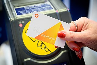
The Key is a contactless ITSO-compatible smartcard developed by the Go-Ahead Group used on buses, trains and other forms of public transport across various areas of the United Kingdom.

Fare capping is a feature of public transport fare collection systems. Fare capping credits the cost of fares for individual trips towards the cost of an unlimited pass, limiting the cost of fares that passengers pay.

References

  1. London Rail and Tube services map
  2. "Getting to Gatwick Airport with Oyster and contactless". Archived from the original on 20 December 2016. Retrieved 15 December 2016.
  3. [Freedom of Information request FOI-0644-2021]
  4. National Rail fares, caps and Travelcards beyond Zone 9