Los Angeles Metro Busway

Last updated

Metro Busway
Lametro.svg
LA metro liner with bicycle rack.jpg
Overview
Locale Los Angeles County, California
Transit type Bus rapid transit
Number of lines2
Number of stations29
Website metro.net
Operation
Began operationOctober 29, 2005;18 years ago (2005-10-29)
Operator(s) Los Angeles County Metropolitan Transportation Authority (Metro)
Technical
System length55.7 mi (89.6 km)
System map
Los Angeles Metro Busway
Los Angeles Metro System Map.png
G Line LACMTA Square G Line.svg  
BSicon CONTg.svg
BSicon PARKING.svg
BSicon INT-L.svg
BSicon KINTa-R orange.svg
Chatsworth
BSicon LOGO Amtrak2.svg Metrolink icon.svg
BSicon STRl.svg
BSicon mKRZo orange+.svg
BSicon dCONTfq.svg
BSicon uKDSTaq.svg
BSicon STR orange.svg
BSicon uABZr+r.svg
BSicon BHF orange.svg
Nordhoff
BSicon BHF orange.svg
Roscoe
BSicon PARKING.svg
BSicon BHF orange.svg
Sherman Way
BSicon uexKHST2.svg
BSicon uexSTRc3.svg
BSicon STRc2 orange.svg
BSicon dSTR3 orange.svg
Warner Center
discontinued
2018
BSicon uexSTRc1.svg
BSicon PARKING.svg
BSicon BHF+1 orange.svg
BSicon uexABZ4+1g.svg
BSicon dSTRc4 orange.svg
Canoga
BSicon BHF orange.svg
De Soto
BSicon PARKING.svg
BSicon BHF orange.svg
Pierce College
BSicon BHF orange.svg
Tampa
BSicon PARKING.svg
BSicon BHF orange.svg
Reseda
BSicon PARKING.svg
BSicon BHF orange.svg
Balboa
BSicon BHF orange.svg
Woodley
BSicon dRP4q.svg
BSicon SKRZ-G4u orange.svg
BSicon dRP4q.svg
BSicon PARKING.svg
BSicon BHF orange.svg
Sepulveda
BSicon PARKING.svg
BSicon BHF orange.svg
Van Nuys
BSicon BHF orange.svg
Woodman
BSicon BHF orange.svg
Valley College
BSicon BHF orange.svg
Laurel Canyon
BSicon dRP4q.svg
BSicon SKRZ-G4u orange.svg
BSicon dRP4q.svg
BSicon tSTRc2 red.svg
BSicon PARKING.svg
BSicon KINTe orange.svg
BSicon tENDE3 red.svg
North Hollywood
LACMTA Circle B Line.svg  
BSicon tCONT1 red.svg
BSicon tSTRc4 red.svg

Wheelchair symbol.svg All stations are accessible

Busway station
BSicon BHF orange.svg
BSicon INT orange.svg
Busway transfer station
Former on-street stop
BSicon uexHST.svg
J Line LACMTA Square J Line.svg  
BSicon CONTg.svg
BSicon PARKING.svg
BSicon STR.svg
BSicon KBHFa grey.svg
El Monte
BSicon STR.svg
BSicon hSTRa grey.svg
BSicon dRP4q.svg
BSicon SKRZ-G4o.svg
BSicon hSKRZ-G4 grey.svg
BSicon dRP4q.svg
BSicon INT-L.svg
BSicon hINT-R grey.svg
Cal State LA
Metrolink icon.svg
BSicon STR.svg
BSicon lhPSL.svg
BSicon UWBl grey.svg
↓ left-side running
BSicon STR.svg
BSicon hBHF grey.svg
LA General Medical Center
BSicon dRP4q.svg
BSicon SKRZ-G4hl.svg
BSicon hSKRZ-G4hru grey.svg
BSicon dRP4q.svg
I-5 (1961).svg I-5
BSicon dCONTgq.svg
BSicon ABZg+lr.svg
BSicon mhKRZ grey+.svg
BSicon CONTfq.svg
BSicon LOGO Amtrak2.svg Metrolink icon.svg
BSicon lINT-Rq.svg
BSicon HUBrg.svg
BSicon KINTe.svg
BSicon HUBeq.svg
BSicon hINTe grey.svg
Union Station
BSicon LOGO Amtrak2.svg Metrolink icon.svg Bus-logo.svg LACMTA Circle A Line.svg   LACMTA Circle B Line.svg   LACMTA Circle D Line.svg  
BSicon dCONTgq blue.svg
BSicon lINT-Lq.svg
BSicon HUBe.svg
BSicon hSTRa@fq blue.svg
BSicon mKRZh grey+blue.svg
BSicon hCONTfq blue.svg
LACMTA Circle A Line.svg  
BSicon FOW grey.svg
↑ El Monte Busway (left-side running)
BSicon uHST.svg
Los Angeles St
BSicon uHST.svg
Spring St/1st St (LA City Hall)
BSicon udINT.svg
1st St/Hill St (Civic Ctr)
LACMTA Circle B Line.svg   LACMTA Circle D Line.svg  
BSicon ubSHI2lr.svg
↓ Grand │ Olive ↑
BSicon uINT(R)f.svg
BSicon uINT(L)g.svg
3rd St/Kosciuszko Wy (Grand/Bunker Hill)
LACMTA Circle A Line.svg   LACMTA Circle E Line.svg  
BSicon uINT(R)f.svg
BSicon uINT(L)g.svg
5th St (Pershing Sq)
LACMTA Circle B Line.svg   LACMTA Circle D Line.svg  
BSicon uSTRf.svg
BSicon uSTRg.svg
↓ Grand │ Olive ↑
BSicon uSTR2.svg
BSicon ulHST.svg
BSicon NUL1.svg
BSicon uSTR3.svg
6th St/Flower St
BSicon uSTR+1.svg
BSicon uSTR+4.svg
↑ Figueroa │ Flower ↓
BSicon uINT(L)g.svg
BSicon uINT(R)f.svg
7th St (7th St/Metro Ctr)
LACMTA Circle A Line.svg   LACMTA Circle B Line.svg   LACMTA Circle D Line.svg   LACMTA Circle E Line.svg  
BSicon uBHF(L)g.svg
BSicon uBHF(R)f.svg
Olympic Bl
BSicon uINT(L)g.svg
BSicon uINT(R)f.svg
Pico Bl (Pico)
LACMTA Circle A Line.svg   LACMTA Circle E Line.svg  
BSicon dRP4q.svg
BSicon uSKRZ-G4hl.svg
BSicon uSKRZ-G4hr.svg
BSicon dRP4q.svg
BSicon uINT(L)g.svg
BSicon uINT(R)f.svg
Washington Bl (Grand/LATTC)
LACMTA Circle A Line.svg  
BSicon uINT(L)g.svg
BSicon uINT(R)f.svg
23rd St (LATTC/Ortho Inst)
LACMTA Circle E Line.svg  
BSicon uBHF(L)g.svg
BSicon uBHF(R)f.svg
Adams Bl
BSicon uKRWl.svg
BSicon KRW+l grey.svg
BSicon uKRWr.svg
BSicon KRW+r grey.svg
↑ Figueroa │ Flower ↓
BSicon SHI2c1 grey.svg
BSicon BS2+lr grey.svg
BSicon SHI2c4 grey.svg
BSicon hBHFa grey.svg
37th Street/USC
BSicon PARKING.svg
BSicon hBHF grey.svg
Slauson
BSicon PARKING.svg
BSicon lKRZu+F.svg
BSicon hBHFe grey.svg
Manchester
BSicon PARKING.svg
BSicon MFADEgq.svg
BSicon CONTgq jade.svg
BSicon vRP2q.svg
BSicon INTq jade.svg
BSicon vRP2BHFq.svg
BSicon MFADEfq.svg
BSicon CONTfq jade.svg
BSicon vRP2q.svg
Harbor Freeway (I-105 (1961).svg I-105)
LACMTA Circle C Line.svg  
BSicon PARKING.svg
BSicon lKRZu+G.svg
BSicon BHF grey.svg
Rosecrans
BSicon dRP4q.svg
BSicon hSKRZ-G4a grey.svg
BSicon dRP4q.svg
BSicon hSTRe grey.svg
↑ Harbor Transitway
BSicon PARKING.svg
BSicon BHF grey.svg
Harbor Gateway
BSicon uHST.svg
Victoria St/190th St
BSicon dRP4q.svg
BSicon uSKRZ-G4u.svg
BSicon dRP4q.svg
BSicon hSTRa grey.svg
BSicon PARKING.svg
BSicon hBHF grey.svg
Carson
BSicon PARKING.svg
BSicon dRP4q.svg
BSicon MSTR.svg
BSicon hBHF grey.svg
BSicon RP4q.svg
BSicon dRP4q.svg
Pacific Coast Highway
BSicon hSTRe grey.svg
↑ Harbor Freeway
BSicon PARKING.svg
BSicon uHST.svg
Harbor Beacon
Ferry symbol.svg
BSicon uHST.svg
Beacon St/1st St
BSicon uHST.svg
Pacific Av/1st St
BSicon uHST.svg
Pacific Av/3rd St
BSicon uHST.svg
Pacific Av/7th St
BSicon uHST.svg
Pacific Av/11th St
BSicon uHST.svg
Pacific Av/15th St
BSicon uHST.svg
Pacific Av/17th St
BSicon uBHF(R)f.svg
Pacific Av/19th St
BSicon uKRW+l.svg
BSicon uKRWgr.svg
BSicon uSTRg.svg
BSicon uHST.svg
Pacific Av/21st St
BSicon ubvvWSLe.svg

Wheelchair symbol.svg All stations are accessible

Busway station
BSicon BHF grey.svg
BSicon INT grey.svg
Busway transfer station
On-street stop
BSicon uHST.svg
BSicon udINT.svg
On-street transfer stop
One-way on-street stop
BSicon uBHF(L)g.svg
BSicon uINT(L)g.svg
One-way on-street
transfer stop

Metro Busway (previously known as Metro Liner and Metro Transitway) is a system of bus rapid transit (BRT) routes that operate primarily along exclusive or semi-exclusive roadways known locally as a busway or transitway. There are currently two lines serving 29 stations (not including street stops) in the system: the G Line in the San Fernando Valley, and the J Line, serving El Monte, Downtown Los Angeles, Gardena, and San Pedro. The Los Angeles County Metropolitan Transportation Authority (Metro) operates the Metro Busway system.

Contents

The G Line, which runs along an exclusive busway, was the first route in the system to open on October 29, 2005. The J Line opened on December 13, 2009, utilizing the pre-existing Harbor Transitway and El Monte Busway, semi-exclusive roadways that are used by both buses and as high-occupancy toll lanes.

Metro Busway routes are designed to mimic Metro Rail services, in both the vehicles' design and their operation. Buses on both lines use a silver livery (similar to the one used on Metro Rail), passengers can board at any door, and vehicles receive priority at intersections. Like Metro Rail, Metro Busway operates on a proof-of-payment honor system, and passengers who have a fare loaded on a TAP card can board from any door. TAP cards can be purchased at vending machines located at stations.

System

Lines

Metro Busway lines are named as part of the naming scheme used for Metro Rail lines, however, the colored icons for the Metro Busway lines are squares instead of the circles used for Metro Rail lines.

Two Metro Busway lines operate in Los Angeles County: [1]

Line nameOpening [1] Length [1] Stations [1] Termini
LACMTA Square G Line.svg  G Line 200517.7 mi (28.5 km)17 Chatsworth (west)
North Hollywood (east)
LACMTA Square J Line.svg  J Line 2009 [lower-alpha 1] 38 mi (61 km)12 El Monte Station (north)
Harbor Gateway Transit Center (south)
Downtown San Pedro (south)
  1. While the roadways the J Line operates on opened as the El Monte Busway in 1973 and as the Harbor Transitway in 1996, the J Line was not established as a through route until 2009 (when it was referred to as the Silver Line).

Corridors

The elevated viaduct of the Harbor Transitway that the Metro J Line operates on. Harbor Fwy Upper Deck2.jpg
The elevated viaduct of the Harbor Transitway that the Metro J Line operates on.

These services operate on three primary corridors (in addition to city streets, where necessary):

History

Metro J Line bus arriving at Los Angeles General Medical Center station on the El Monte Busway LAC & USC Med. Center Metro Silver Line Station- 6.JPG
Metro J Line bus arriving at Los Angeles General Medical Center station on the El Monte Busway

The first busway in the Los Angeles area was the El Monte Busway, which opened in January 1973. The El Monte Busway, which runs parallel to the San Bernardino Freeway, offered an 18-minute trip between El Monte and Downtown Los Angeles, compared to 35–45 minutes in the general-purpose lanes. [2] The facility was a success with about 32,000 boardings per day on lines that used the busway as of November 2000. [3]

Metro J Line bus stopped at Slauson station on the Harbor Transitway Slauson Silver Line Station southbound platform. The new information stands were burly posted last month..jpg
Metro J Line bus stopped at Slauson station on the Harbor Transitway

The area's second busway, the Harbor Transitway, opened in 1996 offering a new connection between Gardena and Downtown Los Angeles. Ridership on the Harbor Transitway was radically lower than expected: Caltrans had projected that 65,200 passengers would travel along the Harbor Transitway each day, but after 10 years, the facility had only attracted 3,000 passengers per weekday. [3]

A third busway to be built in the region came after community revolt against a proposed light rail line in the San Fernando Valley. The Los Angeles County Metropolitan Transportation Authority (Metro) acquired the Southern Pacific Burbank Branch right of way in 1991, intending to utilize the corridor for light rail trains. [4] Neighbors successfully petitioned lawmakers to pass a ban on utilizing transit tax revenue for anything other than an extension of the existing subway into the San Fernando Valley. [5] [6] However, the passage of Proposition A in 1998 cut off funding for any subway projects. With both subway and light rail now legally prohibited, but with growing political pressure to utilize the former railbed, the last available option was a dedicated busway. This proposal was also opposed by neighborhood groups; however, since the previous law did not prohibit it, it moved forward. [7] The busway opened as the Orange Line (now G Line) on October 29, 2005. The line was a success, attracting nearly 23,000 boardings per day in the first year it was open, and nearly 30,000 boardings per day by 2013. [8] The line is so popular, that in 2014 users petitioned lawmakers to repeal the ban on light rail, [9] and Metro now plans to convert the busway to light rail by 2050. [10]

After the successful launch of the busway in the San Fernando Valley, Metro decided to rebrand the county's other busways in an attempt to increase awareness. [11] In March 2006, Metro decided that the Harbor Transitway would be colored bronze and the El Monte Busway would be colored silver on Metro's maps and the two would be marketed as a "Combined Transitway Service." No changes were made in the operations of the bus routes operated on either facility. The changes were criticized as being difficult to understand for irregular and new riders. [12]

In 2009, Metro returned to plan it first proposed in 1993 [13] and created a new bus rapid transit service called the Silver Line (now J Line) utilizing both the Harbor Transitway and the El Monte Busway. The new higher frequency service would be funded by converting both corridors into high occupancy toll (HOT) lanes, to be branded as the Metro ExpressLanes. The bus route began operations on December 13, 2009. Since the J Line's start, Metro has refurbished the aging stations along both the Harbor Transitway and the El Monte Busway, bringing them closer to the amenities provided along the G Line's busway. The plan has led to higher ridership along the corridor, especially along the Harbor Transitway. [8]

On June 30, 2012, the busway used by the G Line buses was extended northward to the Chatsworth Metrolink station, continuing to follow the former Southern Pacific Burbank Branch right-of-way owned by Metro. [14]

The Siliver Line and Orange Line were renamed in 2020, as part of a systemwide rebranding. The Orange Line was renamed the G Line, and the Silver Line became the J Line. [15]

The following table shows the timeline of BRT expansions:

Segment descriptionDate openedLine(s)Endpoints# of new
stations
Busway
length
(miles)
Metro Orange Line initial segmentOctober 29, 2005 LACMTA Square G Line.svg   North HollywoodWarner Center 1314
Canoga stationDecember 27, 2006 LACMTA Square G Line.svg   Canoga 1 [lower-alpha 1]
Metro Silver Line initial segmentDecember 13, 2009 LACMTA Square J Line.svg   El MonteHarbor Gateway 9 [lower-alpha 2] 26
37th Street/USC stationDecember 12, 2010 LACMTA Square J Line.svg   37th Street/USC 1 [lower-alpha 3]
Metro Orange Line Chatsworth ExtensionJune 30, 2012 LACMTA Square G Line.svg  Canoga – Chatsworth 44
Metro Silver Line San Pedro ExtensionDecember 13, 2015 LACMTA Square J Line.svg  Harbor Gateway – San Pedro (Pacific/21st Street)28
Warner Center ShuttleJune 24, 2018 LACMTA Square G Line.svg  Warner Center station removed-1 [lower-alpha 4]
TOTAL2944

Notes:

  1. Canoga was an infill station on the Metro Orange Line, which opened one year later in 2006. The station was built to provide a parking lot near the Warner Center western terminus.
  2. Although the route started in December 2009, the stations used are much older. The El Monte Busway stations opened in 1973 and the Harbor Transitway stations opened in 1996.
  3. When the Metro Silver Line station opened in 2009, buses did not serve the existing 37th Street/USC station (built in 1997) due to detours from the construction of the Metro Expo Line. Service to the station was added one year later in 2010.
  4. The Canoga to Warner Center segment was removed and replaced with a high-frequency shuttle route that serves a larger area of Warner Center.

Future

Metro plans to add additional Metro Busway lines; some projects may have their timelines accelerated under its Twenty-eight by '28 initiative.

On March 17, 2021, Metro staff came forward with five corridors that the agency could pursue to have Bus Rapid Transit implemented in them. [16]

ConceptDescriptionConstructionOperationalStatusRef.
North San Fernando Valley Transit Corridor This project was supposed to be a new east-west Bus Rapid Transit (BRT) route connecting Metro's Chatsworth's Metrolink Station to the North Hollywood station in Los Angeles' San Fernando Valley. As of May 2022, Metro has dropped the single BRT line approach and instead focuses on improving local bus service via peak hour bus lanes on Roscoe Boulevard and signal priority on seven other lines. The project also adds around 400 bus shelters and 80 bus bulbs throughout the San Fernando Valley. Five major bus stops will receive key improvements (two at CSUN), including larger shelters, more seating, new real-time and wayfinding information, and better lighting. Project implementation is expected to begin in fall 2023 and be completed by winter 2025.20232025Approved [17] [18] [19]
North Hollywood to Pasadena Transit Corridor Creates a new east–west BRT route connecting Metro's Memorial Park station in Pasadena to the North Hollywood station in Los Angeles' San Fernando Valley with stops in Eagle Rock, Glendale and Burbank. Metro currently has Measure M and SB-1 state funds to create the line. Project is set to cost under $267 million to construct. The BRT is expected to begin construction by 2024 and open by 2027 with approximately 22 stations. Part of the Twenty-eight by '28 initiative.20242027Approved [20] [21] [22] [23] [24]
Vermont Transit Corridor Create a new north–south subway route down Vermont Avenue extending the HRT B Line at the Wilshire/Vermont Station south, to the Metro E Line and C Line. Included as a Tier 2 Strategic Unfunded Plan project in 2009 Long Range Transportation Plan; a Bus rapid transit line has been funded in the near term by Measure M, but studies will be conducted for possible heavy rail transit, as the Vermont corridor is Metro's second busiest public transportation corridor.20202024Three LPA analysis funded / Pending Draft EIR for BRT [20] [25]
LACMTA Square G Line.svg   G LRT conversion Converting the current G Line Bus Rapid Transit route into LRT. Made possible after the 2014 repeal of state legislation prohibiting LRT along the G Line right of way, which had been enacted due to neighborhood opposition in the 1990s. Bridges along the busway are designed to LRT standards, but the project would require substantial service disruption as the roadway is replaced by rails and catenary wire installed. Some Valley politicians and pressure groups have endorsed the proposal; critics have suggested funding would be better spent on adding new lines along other corridors in the Valley. Long-term plans include complete conversion in phases with full replacement by 2057. Metro began BRT upgrades in 2018 by adding more grade crossing gates, two new viaducts at Van Nuys Blvd and Sepulveda Blvd, reducing travel time by 20%.20512057No current funds available for LRT until 2051 [26] [10] [27]
LACMTA Circle C Line.svg   Lincoln Blvd BRT/LRT Line Extend the LRT C Line from LAX northwest to Venice and Santa Monica Beach and possibly connect with the E Line's western terminus. The C Line was originally engineered to maintain compatibility with this extension. Included in City of Los Angeles Westside Mobility Plan, and as a Tier 2 Strategic Unfunded Plan project in 2009 Long Range Transportation Plan.20432047No LPA or EIR conducted [20] [28]

See also

Template:Attached KML/Los Angeles Metro Busway
KML is not from Wikidata

Related Research Articles

<span class="mw-page-title-main">Los Angeles County Metropolitan Transportation Authority</span> Public transport agency in Los Angeles County, California, United States

The Los Angeles County Metropolitan Transportation Authority (LACMTA), branded as Metro, is the county agency that plans, operates, and coordinates funding for most of the public transportation system in Los Angeles County, California, the most populated county in the United States, and the largest public transit agency in the county as well.

<span class="mw-page-title-main">Los Angeles Metro Rail</span> Urban rail transit system serving Los Angeles County, California

The Los Angeles Metro Rail is an urban rail transit system serving Los Angeles County, California in the United States. It consists of six lines: four light rail lines and two rapid transit lines, serving a total of 101 stations. It connects with the Metro Busway bus rapid transit system, the Metrolink commuter rail system, as well as several Amtrak lines. Metro Rail is owned and operated by the Los Angeles County Metropolitan Transportation Authority (Metro).

<span class="mw-page-title-main">G Line (Los Angeles Metro)</span> Bus rapid transit line in Los Angeles, California

The G Line is a bus rapid transit line in Los Angeles, California, operated by the Los Angeles County Metropolitan Transportation Authority (Metro). It operates between Chatsworth and North Hollywood stations in the San Fernando Valley. The 17.7-mile (28.5 km) G Line uses a dedicated, exclusive right-of-way for the entirety of its route with 17 stations located at approximately one-mile (1.6 km) intervals; fares are paid via TAP cards at vending machines on station platforms before boarding to improve performance. It is one of the two lines in the Los Angeles Metro Busway system.

<span class="mw-page-title-main">North Hollywood station</span> Rapid transit and bus rapid transit station in Los Angeles, California

North Hollywood station is a combined rapid transit and bus rapid transit (BRT) station in the Los Angeles Metro Rail and Metro Busway systems. It is the northwestern terminus of the B Line subway and eastern terminus of the G Line BRT route. It is located at the intersection of Lankershim Boulevard and Chandler Boulevard in the NoHo Arts District of the North Hollywood neighborhood in the San Fernando Valley of Los Angeles.

<span class="mw-page-title-main">Harbor Transitway</span> Roadway in Interstate Highway 110 in Los Angeles County, California

The Harbor Transitway is a 10.3-mile (16.6 km) shared-use express bus corridor and high occupancy toll (HOT) lanes running in the median of Interstate 110 between Downtown Los Angeles and the Harbor Gateway Transit Center in Gardena, California. Buses also make intermediate stops at 37th Street/USC, Slauson, Manchester, Harbor Freeway, and Rosecrans stations. The facility opened for two-person carpools on June 26, 1996, for buses on August 1, 1996 and was converted to HOT lanes as part of the Metro ExpressLanes project on November 10, 2012.

<span class="mw-page-title-main">El Monte Busway</span> Los Angeles Metro Busway

The El Monte Busway is a 12-mile (19 km) shared-use express bus corridor (busway) and high occupancy toll (HOT) lanes running along Interstate 10 between Union Station in Downtown Los Angeles and Interstate 605 or El Monte Station in El Monte, California. Buses also make intermediate stops at Cal State LA station and LA General Medical Center station. The busway opened in January 1973 to buses only, three-person carpools were allowed to enter in 1976, and the facility was converted to HOT lanes as part of the Metro ExpressLanes project on February 22, 2013.

<span class="mw-page-title-main">Van Nuys station (Los Angeles Metro)</span> Bus rapid transit station in Los Angeles, California

Van Nuys station is a station on the G Line of the Los Angeles Metro Busway system. It is named after adjacent Van Nuys Boulevard, which travels north-south and crosses the east-west busway route and is located in the Van Nuys district of Los Angeles, in the San Fernando Valley. Adjacent to the station is the G Line Bikeway.

<span class="mw-page-title-main">Harbor Freeway station</span> Light rail and bus rapid transit station in Los Angeles, California

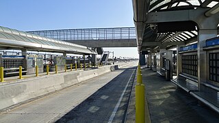
Harbor Freeway station is a transport hub located on the Harbor Transitway, within the Judge Harry Pregerson Interchange of Interstate 105 and Interstate 110 near Figueroa Street in the neighborhood of South Los Angeles. The station is served by the light rail C Line, the bus rapid transit J Line and other bus services. The station is owned by the California Department of Transportation (Caltrans) and operated by the Los Angeles County Metropolitan Transportation Authority (Metro).

<span class="mw-page-title-main">37th Street/USC station</span> Bus rapid transit station in Los Angeles, California

37th Street/USC station is a busway station located in Los Angeles, California. It is situated between the LATTC/Ortho Institute and Slauson stations on the J Line, a bus rapid transit route which runs between El Monte, Downtown Los Angeles and San Pedro as part of the Metro Busway system. The station consists of two side platforms in the center of Interstate 110 above 37th Street, adjacent to the University of Southern California campus. The station serves the University Park, Exposition Park and Historic South Central neighborhoods of Los Angeles.

<span class="mw-page-title-main">Slauson station (J Line)</span> Bus rapid transit station in Los Angeles, California

Slauson station is a busway station located in Los Angeles, California. It is situated between the 37th Street/USC and Manchester stations on the J Line, a bus rapid transit route which runs between El Monte, Downtown Los Angeles and San Pedro as part of the Metro Busway system. The station consists of two side platforms in the center of Interstate 110 above Slauson Avenue. The station serves the Vermont-Slauson, South Park and Florence neighborhoods of Los Angeles.

<span class="mw-page-title-main">Manchester station (Los Angeles Metro)</span> Bus rapid transit station in Los Angeles, California

Manchester station is a busway station located in Los Angeles, California. It is situated between the Slauson and Harbor Freeway stations on the J Line, a bus rapid transit route which runs between El Monte, Downtown Los Angeles and San Pedro as part of the Los Angeles Metro Busway system. The station consists of two side platforms in the center of Interstate 110 above Manchester Avenue. The station serves the Vermont Knolls, Vermont Vista, Florence, and Broadway-Manchester neighborhoods of Los Angeles.

<span class="mw-page-title-main">Rosecrans station</span> Bus rapid transit station in Los Angeles, California

Rosecrans station is a busway station located in Los Angeles, California. It is situated between the Harbor Freeway station and the Harbor Gateway Transit Center on the J Line, a bus rapid transit route which runs between El Monte, Downtown Los Angeles and San Pedro as part of the Metro Busway system. The station consists of two side platforms in the center of Interstate 110 under Rosecrans Avenue. The station serves the Harbor Gateway neighborhoods of Los Angeles.

<span class="mw-page-title-main">Harbor Gateway Transit Center</span> Public transit hub in Los Angeles, California

Harbor Gateway Transit Center, formerly Artesia Transit Center, is a large bus station at the southern end of the Harbor Transitway that serves as a transport hub for the South Bay region of Los Angeles County including the Harbor Gateway neighborhood of Los Angeles and cities of Carson, Gardena, and Torrance. The station consists of one large island platform with 12 bus bays and a 980 space park and ride parking lot located in the southwest corner of Interstate 110 and California State Route 91.

<span class="mw-page-title-main">Cal State LA station</span> Commuter rail and busway station in Los Angeles, California

Cal State LA station is a commuter rail and busway station located on the El Monte Busway. The station is located between Interstate 10 and its namesake, the campus of California State University, Los Angeles. It is located in the El Sereno neighborhood of the City of Los Angeles and Eastside region, in southern California. The busway portion of the station opened on February 18, 1975 and the Metrolink platform was added on October 26, 1994.

<span class="mw-page-title-main">El Monte Station</span> Transit center in Los Angeles, California

El Monte Station is a large regional bus station in the city of El Monte, California, United States, adjacent to Interstate 10, serving the Metro J Line, Foothill Transit, Greyhound Lines, and El Monte Transit. It is the Metro J Line's eastern terminus.

<span class="mw-page-title-main">J Line (Los Angeles Metro)</span> Bus rapid transit line in Los Angeles County, California

The J Line is a 38-mile (61.2 km) bus rapid transit line that runs between El Monte, Downtown Los Angeles and the Harbor Gateway, with some trips continuing to San Pedro. It is one of the two lines in the Metro Busway system operated by the Los Angeles County Metropolitan Transportation Authority (Metro).

This article discusses the history of the Los Angeles County Metropolitan Transportation Authority, the regional transportation planning agency for Los Angeles County, California.

The Metro ExpressLanes project is a transport project in Los Angeles County, California that debuted in 2012 to "improve traffic flow and provide enhanced travel options on I-10 and I-110 in Los Angeles County". It includes a range of infrastructure developments on the Harbor Transitway and the El Monte Busway. The existing high-occupancy lanes on these transitways were converted to high-occupancy toll lanes. Associated works included a major upgrade to the El Monte bus station, expansion of Metrolink's Pomona–North station, the creation of a new transit station at Union Station, and increased park and ride capacity and bike lockers at many transit stations. In addition, new vanpool vehicles and buses will be purchased. The project was delivered by the Los Angeles County Metropolitan Transportation Authority, the California Department of Transportation, and others. The budget was $290 million and construction, which began in 2011, was completed in February 2013. Some transit improvements for the Metro J Line are still being worked on.

The history of the Los Angeles Metro Rail and Busway system begins in the early 1970s, when the traffic-choked region began planning a rapid transit system. The first dedicated busway opened along I-10 in 1973, and the region's first light rail line, the Blue Line opened in 1990. Today the system includes over 160 miles (260 km) of heavy rail, light rail, and bus rapid transit lines, with multiple new lines under construction as of 2019.

References

  1. 1 2 3 4 "Facts At A Glance". Los Angeles County Metropolitan Transportation Authority. June 2023. Archived from the original on March 19, 2023. Retrieved June 22, 2023.
  2. "40 Years Ago This Week: Groundbreaking For El Monte Busway — California's First Multi-Modal System & The World's First Bus Rapid Transit Station". Dorothy Peyton Gray Transportation Library and Archive. January 24, 2012. Retrieved November 29, 2020.
  3. 1 2 Shuit, Douglas P. (November 20, 2000). "Harbor Transitway Has Everything but Riders". Los Angeles Times.
  4. Curtiss, Aaron (April 7, 1996). "Tracks to the Past". Los Angeles Times. Retrieved April 2, 2024.
  5. Broverman, Neal (February 4, 2014). "State Could be About to Repeal Ban on Light Rail in the Valley". LA Curbed. Retrieved October 16, 2015.
  6. "Public utilities code section 130250-130265". Archived from the original on December 12, 2012.
  7. "Legal arguments against the busway".
  8. 1 2 "Metro Ridership". Metro.net. Los Angeles County Metropolitan Transportation Authority. February 2020. Retrieved December 1, 2020.
  9. Broverman, Neal (July 8, 2014). "It's Now Legal to Build Light Rail in the San Fernando Valley". LA Curbed. Retrieved October 16, 2015.
  10. 1 2 Olga, Grigoryants (July 17, 2018). "LA's Metro says improvements are in the works for the Orange Line, with light rail in mind". Los Angeles Daily News. Retrieved July 17, 2018.
  11. Emsden, Maya (March 16, 2006). "Approve color designations for Metro lines and fixed guideways" (PDF). Los Angeles County Metropolitan Transportation Authority.
  12. Freemark, Yonah (December 10, 2009). "Los Angeles Integrates Service on Two Busways, with Plans to Implement Congestion Pricing". The Transport Politic. Retrieved November 25, 2020.
  13. "Dual Hub High Occupancy Vehicle Transitway Report" (PDF). Los Angeles County Metropolitan Transportation Authority Scheduling and Operations Planning Staff. August 1993.
  14. "Item 44 Program Management Project Budget and Schedule Status" (PDF). Metro. January 18, 2012. p. 3. Retrieved December 26, 2013.
  15. Fonseca, Ryan (January 8, 2020). "LA Metro's New Train And Bus Names Are Official. Time To Learn Your Transit ABCs". LAist. Retrieved April 2, 2024.
  16. "Metro Staff Recommend Five Corridors". Urbanize. March 17, 2021. Retrieved March 17, 2021.
  17. "North San Fernando Valley Bus Rapid Transit Improvements News". Urbanize.la. Retrieved February 15, 2020.
  18. North San Fernando Valley Transit Corridor – Project Update Summer 2022 , retrieved May 29, 2022
  19. "North San Fernando Valley Transit Corridor". LA Metro. Retrieved July 28, 2023.
  20. 1 2 3 "2009 Long Range Transportation Plan" (PDF). Los Angeles County Metropolitan Transportation Authority (Metro). 2010. p. 31. Retrieved January 9, 2016.
  21. Sharp, Steven (October 1, 2018). "Planning for North Hollywood - Pasadena Bus Rapid Transit Line Moves Forward". Urbanize LA. Retrieved February 15, 2020.
  22. "Community meetings begin this month for NoHo to Pasadena Bus Rapid Transit project - The Source". Thesource.metro.net. September 25, 2018. Retrieved February 15, 2020.
  23. "That Rapid Bus Line from North Hollywood to Pasadena is Officially Happening". MSN .
  24. "Update on LA Metro's North Hollywood to Pasadena BRT project". March 29, 2023. Retrieved March 29, 2023.
  25. "A subway on Vermont? Metro is considering it - Curbed LA". La.curbed.com. May 7, 2018. Retrieved February 15, 2020.
  26. Hymon, Steve (July 9, 2014). "Transportation headlines, Wednesday, July 9". The Source. Metro . Retrieved January 19, 2016.
  27. "Metro breaks ground on Orange Line Improvements Project - The Source". Thesource.metro.net. October 12, 2018. Retrieved February 15, 2020.
  28. "Measure M project descriptions - The Source". Thesource.metro.net. November 8, 2016. Retrieved February 15, 2020.