Southeast Gateway Line

Last updated

LAMetroLogo.svg  Southeast Gateway Line
Overview
StatusPlanned
Locale Los Angeles
Downey
Paramount
Artesia
Termini
Stations12
Website Southeast Gateway Line
Service
Type Light rail
System Los Angeles Metro Rail
History
Planned opening2028 (if accelerated)
2035 (Slauson–Pioneer)
2043 (full line)
Technical
Line length19.3 mi (31.1 km)
Number of tracks2
CharacterDedicated right of way with elevated, at-grade and underground sections
Track gauge 4 ft 8+12 in (1,435 mm) standard gauge
Electrification 750 V DC overhead catenary
Route map

Contents

BSicon exdCONTg.svg
BSicon dCONTg.svg
BSicon dCONTg blue.svg
BSicon exdSTR.svg
BSicon dSTR.svg
BSicon tSTRc2 black.svg
BSicon lINT-L.svg
BSicon HUBrg.svg
BSicon tENDE3 black.svg
BSicon dHUBq.svg
BSicon dINT-M blue.svg
BSicon dHUBq.svg
BSicon xdINT-M.svg
BSicon cdHUBeq.svg
BSicon dKINTxe-R.svg
Union Station LACMTA Circle A Line.svg   LACMTA Circle B Line.svg   LACMTA Circle D Line.svg   LACMTA Square J Line.svg   Metrolink icon 2022.svg BSicon LOGO Amtrak2.svg California High Speed Rail.svg
BSicon tdCONT1- black.svg
BSicon extKINTa lavender.svg
BSicon HUBe.svg
BSicon tSTRc4 black.svg
BSicon tdSTRa@g blue.svg
BSicon exdCONTf.svg
BSicon exdCONTf.svg
*new platforms at Union Station Forecourt
or behind the Metropolitan Water District Building
LACMTA Circle B Line.svg   LACMTA Circle D Line.svg  
BSicon tdCONTgq black.svg
BSicon tINTq black.svg
BSicon exKBL2.svg
BSicon xmtKRZtu lavender+black.svg
BSicon exBLc3.svg
BSicon tdSTRq saffron.svg
BSicon tdSTRr blue.svg
BSicon tCONTfq saffron.svg
LACMTA Circle A Line.svg   LACMTA Circle E Line.svg  
BSicon exBLc1.svg
BSicon extINT lavender.svg
BSicon exKBL4.svg
Little Tokyo/Arts District LACMTA Circle A Line.svg   LACMTA Circle E Line.svg  
BSicon extBHF lavender.svg
Arts/Industrial District
BSicon MFADEgq.svg
BSicon hRP4q.svg
BSicon hPORTALg.svg
BSicon exhSKRZ-G4ho lavender.svg
BSicon MFADEfq.svg
BSicon hRP4q.svg
BSicon LSTR+r blue.svg
BSicon xhENDE lavender.svg
Arrow Blue Up 001.svgPhase 2 (2043)
Arrow Blue Down 001.svgPhase 1 (2035)
BSicon hBHFae blue.svg
BSicon exlINT-L.svg
BSicon exhINT-R lavender.svg
Slauson LACMTA Circle A Line.svg  
BSicon CONTf blue.svg
BSicon exhSTRe lavender.svg
LACMTA Circle A Line.svg  to Long Beach
BSicon exBHF lavender.svg
Pacific/Randolph
BSicon exBHF lavender.svg
Florence/Salt Lake
BSicon PARKING.svg
BSicon exhBHFae lavender.svg
Firestone
BSicon dRP4q.svg
BSicon exSKRZ-G4u lavender.svg
BSicon dRP4q.svg
BSicon exBHF lavender.svg
Gardendale
BSicon PARKING.svg
BSicon exINT lavender.svg
BSicon lhSTRa@f.svg
BSicon exKBL2.svg
BSicon exBLc3.svg
I-105/C Line LACMTA Circle C Line.svg  
BSicon MFADEgq.svg
BSicon CONTg@Gq jade.svg
BSicon vRP2q.svg
BSicon STRq jade.svg
BSicon MSTR.svg
BSicon exhSTR lavender.svg
BSicon exBLc1.svg
BSicon vRP2q.svg
BSicon exKBL4.svg
BSicon eINTq jade.svg
BSicon vRP2BHFq.svg
BSicon dCONTfq jade.svg
I-105 (1961).svg I-105 LACMTA Circle C Line.svg  
BSicon PARKING.svg
BSicon exhBHFe lavender.svg
Paramount/Rosecrans
BSicon dRP2q.svg
BSicon exSKRZ-G2o lavender.svg
BSicon dRP2q.svg
BSicon exSTR lavender.svg
BSicon uexABZl+l.svg
BSicon uexKDSTeq.svg
Maintenance and
Storage Facility
BSicon PARKING.svg
BSicon exBHF lavender.svg
Bellflower
BSicon dRP4q.svg
BSicon exSKRZ-G4u lavender.svg
BSicon dRP4q.svg
BSicon dRP4q.svg
BSicon exSKRZ-G4u lavender.svg
BSicon dRP4q.svg
BSicon PARKING.svg
BSicon exKBHFe lavender.svg
BSicon exSTR.svg
Pioneer
BSicon exCONTf@F.svg
BSicon tSTRq black.svg
Multiple services

Wheelchair symbol.svg All stations are accessible

The Southeast Gateway Line, formerly the West Santa Ana Branch Transit Corridor, is a planned light rail line, mostly following the Pacific Electric's historic West Santa Ana Branch, connecting Downtown Los Angeles to the city of Artesia, along with other cities in southeastern Los Angeles County.

Overview

The Los Angeles County Metropolitan Transportation Authority (Metro) has $4 billion [1] [2] in funds available for construction planned to begin in 2022. The plan included in the Measure M transportation funding measure is to build improvements in two stages.

In June 2017, Metro issued a request for proposal (RFP) to study alternatives for this new line. [3] Metro has narrowed the options to two alternatives and are currently preparing to publish the Draft EIS/EIR for public comment. [2] [1] The draft EIS/EIR is planned to be released in 2020. [4]

The project's timeline was expected to be accelerated under the Twenty-eight by '28 initiative. [5]

The environmental impact report released in 2021 set an estimated cost of $8.6 billion for the line. [6]

The City of Cerritos filed a lawsuit[ when? ] to force Metro to alter the planned route through that city. Under the plan, the new light rail will travel over 1.3 miles (2.09 km) within the city limits with three street crossings between I-605 and the proposed Pioneer station. Metro proposes in Cerritos, at 183rd and Gridley Street, a crossing shared with the City of Artesia, a $687 million dollar above ground bridge crossing. Cerritos prefers a $1.1 billion dollar underground rail options within its limits. Metro has stated a budget difference of $413 million in additional tax payer funds is not needed. [7] [8]

By 2023, the Metro board sought to change the project's name to reflect that it would not reach Santa Ana or Orange County. [9] The $8.5 billion project has been in the planning stage for two decades. Metro estimates it will take 10 years to build, starting in 2025 and opening in 2035. On January 22, 2024, the line's new name was announced by Los Angeles County Supervisor Janice Hahn to be the Southeast Gateway Line. [10]

On March 29, 2024, Metro publicly published the final environmental impact report (EIR) for the project, pending certification by the Metro board of directors. The FTA is expected to issue a record of decision to happen sometime during the summer of 2024. [11] The board voted to certify the EIR at a meeting on April 25, 2024, paving the way for construction to begin by the end of 2024. [12] Metro released an RFP right after the certification, seeking a contractor for pre-construction "Advanced Works". [13]

Proposed routings and modes

The Southeast Gateway Line is proposed as a 19.3-mile (31.1 km) light rail transit line that would connect downtown Los Angeles to Artesia. Along the route, it would also serve the communities of Vernon, Huntington Park, Bell, Cudahy, South Gate, Downey, Paramount, Bellflower and Cerritos in the southeast area of the county. [1]

The southern portion route, east and south of Slauson, leaves the A Line corridor via the former Pacific Electric Whittier Line, continues south on a former Union Pacific Railroad line (Florence/Salt Lake to Paramount/Rosecrans), and then transitions to the old Santa Ana right of way (south of Paramount/Rosecrans). These corridors are owned by the Ports of Los Angeles/Long Beach and Metro, requiring minimal property acquisition.

The northern alignment through Downtown Los Angeles is being studied as a possible underground light rail transit route. Six options were proposed. [1] As of 2018, two options were being considered (both of which would connect to the southern alignment by paralleling the A Line between Washington and Slauson stations, as well as part of an existing freight rail line along Randolph Street): [4] [2]

By March 2018, Cerritos had opted out of the project, leaving the southern terminus at Pioneer. [14] In November 2018, Metro removed the A Line stations north of Slauson from the study area, citing redundant service and expedited travel times as the prime reasons. [15]

In 2019, Metro announced that as part of its design analysis, it would study opening the line in two stages, with the initial opening $1 billion segment running from Pioneer Station in Artesia north to Slauson Station on the A Line, with the remainder of the $3 billion route into downtown built as Phase 2. Metro staff were "optimistic" that it would be feasible to build the line to Slauson by 2028 with existing Measure M funds. Metro was also studying public–private partnerships that could accelerate the construction schedule of the entire line. The service is not planned to interline with the A Line to 7th Street/Metro Center due to operational constraints. [16] Under the proposed plans, design for the initial segment would be complete by 2021 and construction would begin in 2022. [17]

Route Selection: Alternative: E

By 2022, the Metro Board backed the Union Station option as the northern terminus. [18] Construction on the segment south of Slauson is expected to begin construction in 2025 with an estimated opening of 2035. [19] [20] The second phase north of Slauson to Union Station is expected to be completed in 2043 at the earliest. [21]

Stations

PhaseExpected
completion
Station [1] LocationConnecting
services [22]
22043 Union Station Downtown Los Angeles BSicon LOGO Amtrak2.svg Amtrak
California High Speed Rail.svg California High-Speed Rail (planned)
Metrolink icon 2022.svg Metrolink
LACMTA Circle A Line.svg  A Line
LACMTA Circle B Line.svg  B Line
LACMTA Circle D Line.svg  D Line
LACMTA Square J Line.svg  J Line
Little Tokyo/Arts District Little Tokyo LACMTA Circle A Line.svg  A Line
LACMTA Circle E Line.svg  E Line
Arts/Industrial District Arts District
12035 [9] Slauson Florence-Graham LACMTA Circle A Line.svg  A Line
Pacific/Randolph Huntington Park/Walnut Park
Florence/Salt Lake Bell/Cudahy
Firestone South Gate
Gardendale Downey
I-105/C Line Paramount LACMTA Circle C Line.svg  C Line
Paramount/Rosecrans
Bellflower Bellflower
Pioneer Artesia

Proposed extension into Orange County

Metro is evaluating an optional station in Cerritos at Bloomfield Avenue (just north of the Los Angeles-Orange county line) to facilitate a possible future extension into Orange County; it would eventually connect to the under-construction OC Streetcar, which also uses part of the Pacific Electric WSAB right-of-way. [4]

Proposed Rio Hondo confluence station

Metro is evaluating an optional station in South Gate at the confluence of the Los Angeles River and Rio Hondo to connect with future planned development in the surrounding area. [23]

Related Research Articles

<span class="mw-page-title-main">Orange County Transportation Authority</span> Transportation planning commission for Orange County, California

The Orange County Transportation Authority (OCTA) is the transportation planning commission for Orange County, California in the Los Angeles metropolitan area. OCTA is responsible for funding and implementing transit and capital projects for the transportation system in the county, including freeway expansions, express lane management, bus and rail transit operation, and commuter rail funding and oversight.

<span class="mw-page-title-main">Los Angeles County Metropolitan Transportation Authority</span> Public transport agency in Los Angeles County, California, United States

The Los Angeles County Metropolitan Transportation Authority (LACMTA), branded as Metro, is the county agency that plans, operates, and coordinates funding for most of the public transportation system in Los Angeles County, California, the most populated county in the United States, and the largest public transit agency in the county as well.

<span class="mw-page-title-main">Gateway Cities</span> Region of Los Angeles County, California, US

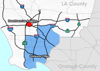
The Gateway Cities Region, or Southeast Los Angeles County, is an urbanized region located in southeastern Los Angeles County, California, between the City of Los Angeles proper, Orange County, and the Pacific Ocean. The cluster of cities has been termed "Gateway Cities" in that they serve as a "gateway" between the LA and Orange counties, with the city of Cerritos equidistant from Downtown L.A., Long Beach, and Santa Ana in Orange County. As such, the area is central to the Los Angeles-Long Beach-Anaheim, CA Metropolitan Statistical Area (MSA), and has a population of approximately 2,000,000 residents.

<span class="mw-page-title-main">San Bernardino Line</span> Commuter rail line in Southern California

The San Bernardino Line is a Metrolink line running between Downtown Los Angeles east through the San Gabriel Valley and the Inland Empire to San Bernardino, with limited express service to Redlands. It is one of the three initial lines on the original Metrolink system, along with the Santa Clarita Line and the Ventura County Line.

<span class="mw-page-title-main">Los Angeles Metro Rail</span> Urban rail transit system serving Los Angeles County, California

The Los Angeles Metro Rail is an urban rail transit system serving Los Angeles County, California in the United States. It consists of six lines: four light rail lines and two rapid transit lines, serving a total of 101 stations. It connects with the Metro Busway bus rapid transit system, the Metrolink commuter rail system, as well as several Amtrak lines. Metro Rail is owned and operated by the Los Angeles County Metropolitan Transportation Authority (Metro).

<span class="mw-page-title-main">A Line (Los Angeles Metro)</span> Light rail line in Los Angeles County, California

The A Line is a 48.5-mile (78.1 km) light rail line in Los Angeles County, California. It is one of the six lines of the Los Angeles Metro Rail system, operated by the Los Angeles County Metropolitan Transportation Authority (Metro). The A Line serves 44 stations and runs east-west between Azusa and Pasadena, then north-south between Pasadena and Long Beach. It interlines and shares five stations with the E Line in Downtown Los Angeles. Service operates for approximately 19 hours with headways of up to 8 minutes during peak hours. The A Line is currently the longest light rail line in the world.

<span class="mw-page-title-main">E Line (Los Angeles Metro)</span> Light rail line in Los Angeles County, California

The E Line is a 22-mile (35 km) light rail line in Los Angeles County, California. It is one of the six lines of the Los Angeles Metro Rail system, operated by the Los Angeles County Metropolitan Transportation Authority (Metro). The E Line runs east-west and serves 29 stations between East Los Angeles and Santa Monica. It interlines and shares five stations with the A Line in Downtown Los Angeles. Service operates for approximately 19 hours with headways of up to 8 minutes during peak hours. The E Line, the second-busiest light rail line in the system, saw an average of 41,902 passengers on weekdays in October 2023.

<span class="mw-page-title-main">Slauson station (A Line)</span> Light rail station in Los Angeles, California

Slauson station is an elevated light rail station on the A Line of the Los Angeles Metro Rail system. The station is located within the historic right-of-way of the Pacific Electric Railway and elevated over the intersection of Slauson Avenue, after which the station is named, in the unincorporated Los Angeles County community of Florence.

<span class="mw-page-title-main">Regional Connector</span> Transit project in Los Angeles

The Regional Connector Transit Project constructed a 1.9-mile (3.1 km) light rail tunnel for the Los Angeles Metro Rail system in Downtown Los Angeles. It connected the A and E lines with the former L Line. The A and E lines previously both terminated at 7th Street/Metro Center station, coming from Long Beach and Santa Monica, respectively, while the L Line ran through Little Tokyo/Arts District to either Azusa or East Los Angeles. Now the A and E lines continue together through new stations at Grand Avenue Arts/Bunker Hill, Historic Broadway, and Little Tokyo/Arts District. From there, they diverge on the former L Line toward Azusa and East Los Angeles, respectively. The project provides a one-seat ride into the core of Downtown for passengers on those lines who previously needed to transfer, thus reducing or altogether eliminating many transfers of passengers traveling across the region via Downtown Los Angeles.

<span class="mw-page-title-main">Harbor Gateway Transit Center</span> Public transit hub in Los Angeles, California

Harbor Gateway Transit Center, formerly Artesia Transit Center, is a large bus station at the southern end of the Harbor Transitway that serves as a transport hub for the South Bay region of Los Angeles County including the Harbor Gateway neighborhood of Los Angeles and cities of Carson, Gardena, and Torrance. The station consists of one large island platform with 12 bus bays and a 980 space park and ride parking lot located in the southwest corner of Interstate 110 and California State Route 91.

<span class="mw-page-title-main">Norwalk Transit (California)</span>

Norwalk Transit is a municipal transit company providing fixed-route and paratransit bus transit services in Norwalk, California, United States, and also operates in portions of Artesia, Bellflower, Cerritos, La Habra, La Mirada, Santa Fe Springs and Whittier in southeast Los Angeles County and northwestern Orange County. In 2023, the system had a ridership of 998,000, or about 4,200 per weekday as of the fourth quarter of 2023.

<span class="mw-page-title-main">West Santa Ana Branch</span> Rail line in California, US

The West Santa Ana Branch is a rail right-of-way formerly used by the Pacific Electric's (PE) Santa Ana route in Los Angeles County and Orange County in Southern California. The Los Angeles County Metropolitan Transportation Authority (Metro) owns the segment of the right-of-way in Los Angeles County, and the Orange County Transportation Authority (OCTA) owns the segment in Orange County.

<span class="mw-page-title-main">Santa Ana Line</span>

The Santa Ana Line was an interurban railway route connecting Los Angeles and Santa Ana in Orange County. It ran between 1905 and 1958 and was predominantly operated by the Pacific Electric Railway for its history.

<span class="mw-page-title-main">Foothill Extension</span> Light rail extension project in Los Angeles County, California

The Foothill Extension Project, formerly known as the Gold Line Foothill Extension Project, is an extension of the Los Angeles Metro Rail A Line light rail line from the former Gold Line terminus in Pasadena, California, at Sierra Madre Villa station, east through the "Foothill Cities" of Los Angeles County. The plan's first stage, Phase 2A, extended the then-Gold Line from Pasadena to Azusa; it opened on March 5, 2016. Phase 2B, which will extend the now A Line a further four stations to Pomona–North station, broke ground in December 2017. A further two–station extension to Montclair Transcenter is planned for completion in 2028, but is currently unfunded.

<span class="mw-page-title-main">Sepulveda Transit Corridor</span> Proposed transit corridor in Los Angeles, California

The Sepulveda Transit Corridor Project is a two-phased planned transit corridor project that aims to connect the Los Angeles Basin to the San Fernando Valley through Sepulveda Pass in Los Angeles, California, by supplementing the existing I-405 freeway through the pass. The corridor would partly parallel I-405, and proposed alternatives include heavy rail rapid transit or a monorail line connecting the G Line in the Valley to the D Line and E Line on the Westside, and the K Line near Los Angeles International Airport.

The OC Streetcar is a modern streetcar line currently under construction in Orange County, California, running through the cities of Santa Ana and Garden Grove. The electric-powered streetcar will be operated by the Orange County Transportation Authority (OCTA), and will serve ten stops in each direction along its 4.15-mile (6.68 km) route.

The East San Fernando Valley Light Rail Transit Project, formerly the East San Fernando Valley Transit Corridor Project, is a transit project which is proposing the construction of a light rail line on the east side of Los Angeles's San Fernando Valley, running on a north/south route along Van Nuys Boulevard and San Fernando Road.

<span class="mw-page-title-main">Eastside Transit Corridor</span> Future light rail line extension in Los Angeles County, California

The Eastside Transit Corridor is a light rail line extension that currently connects Downtown Los Angeles with East Los Angeles. However, the extension is planned to extend further southeast to connect with the Gateway Cities, continuing from a relocated Atlantic station southeast to a new Lambert station in Whittier.

The history of the Los Angeles Metro Rail and Busway system begins in the early 1970s, when the traffic-choked region began planning a rapid transit system. The first dedicated busway opened along I-10 in 1973, and the region's first light rail line, the Blue Line opened in 1990. Today the system includes over 160 miles (260 km) of heavy rail, light rail, and bus rapid transit lines, with multiple new lines under construction as of 2019.

<span class="mw-page-title-main">Rail to Rail</span> Under construction rail trail in Los Angeles County, California

The Rail to Rail Active Transportation Corridor Project is a construction project building a rail trail in Los Angeles County, California, United States. It is being constructed by the Los Angeles County Metropolitan Transportation Authority (Metro).

References

  1. 1 2 3 4 5 "West Santa Ana Branch Transit Corridor". Los Angeles County Metropolitan Transportation Authority. Retrieved June 28, 2018.
  2. 1 2 3 Tinoco, Matt (May 24, 2018). "Metro directors pick two options for new rail line through Downtown LA". Curbed LA. Retrieved February 2, 2021.
  3. "Metro West Santa Ana Branch Rail Recommended Route(s) To Go To Metro Board This Month". Streetsblog Los Angeles. May 2018. Retrieved June 28, 2018.
  4. 1 2 3 "Project Alternatives". Los Angeles County Metropolitan Transportation Authority. Retrieved December 2, 2018.[ non-primary source needed ]
  5. Sharp, Steven (November 27, 2018). "Here are the 28 Projects that Metro Could Complete Before the 2028 Olympics". Urbanize. Retrieved July 2, 2018.
  6. Fine, Howard (December 20, 2021). "Metro Planning Rail Routes into County's Southeast Quadrant". Los Angeles Business Journal. Retrieved December 31, 2021.
  7. "Cerritos Council Spending City Funds to Stop Light Rail from Artesia to Downtown L.A." July 2023.
  8. "Let the new Metro line in Cerritos be built | Talon Marks". March 25, 2023.
  9. 1 2 Scauzillo, Steve (June 15, 2023). "Stations, new name coming for West Santa Ana Branch light-rail in southeast LA County". Los Angeles Daily News. Retrieved June 19, 2023.
  10. @SupJaniceHahn (January 22, 2024). "Over the last few months, I asked for your help to come up with a new name, and you all came through. Metro has tabulated the results and now we are finally prepared to unveil the new name for this train. The name you all chose for this new line is… the Southeast Gateway Line!" (Tweet). Retrieved January 22, 2024 via Twitter.
  11. "EIS_EIR". Dropbox . Retrieved April 17, 2024.
  12. "Metro certifies environmental impact report for Southeast Gateway Rail Line". Los Angeles Daily News . MediaNews Group. April 25, 2024. Retrieved April 25, 2024.
  13. @numble (April 26, 2024). "LA Metro has released the RFP for a contractor for "Advanced Works" for Southeast Gateway Line, to prepare alignment for main project construction (utility relocations, soil abatement, freight relocation, etc.). Contract might also include building C Line infill transfer station" (Tweet). Retrieved April 26, 2024 via Twitter.
  14. Hews, Brian (March 11, 2018). "METRO TO HOLD MEETINGS ON WEST SANTA ANA BRANCH TRANSIT PROJECT, THE 20-MILE LIGHT RAIL FROM ARTESIA TO DOWNTOWN LOS ANGELES". Cerritos Community News. Hews Media Group. Retrieved February 2, 2021.
  15. "Board Report" (PDF). metro.net. Los Angeles County. November 14, 2018. pp. 1–33. Retrieved March 14, 2023.[ non-primary source needed ]
  16. "Board Report" (PDF). metro.net. Los Angeles County. September 18, 2019. pp. 1–6. Retrieved March 14, 2023.[ non-primary source needed ]
  17. "LA Metro to present latest West Santa Ana light-rail plan to the public". Progressive Railroading. January 2, 2021. Retrieved February 2, 2021.
  18. Hymon, Steve (January 18, 2022). "Metro Board to select route and terminus for light rail line to Southeast L.A. County". The Source. LACMTA. Retrieved January 21, 2022.
  19. Sharp, Steven (January 17, 2022). "Metro staff recommend Union Station route for West Santa Ana Branch". Urbanize. Retrieved January 21, 2022.
  20. 2021-0724 - WEST SANTA ANA BRANCH TRANSIT CORRIDOR PROJECT (Report). January 19, 2022. p. 2. Retrieved January 21, 2022.{{cite report}}: Unknown parameter |agency= ignored (help)
  21. Scauzillo, Steve (January 27, 2022). "LA Metro board OKs new light-rail line from Artesia to Union Station". Los Angeles Daily News. Retrieved January 28, 2022.
  22. "Bus and Rail System Map" (PDF). Los Angeles County Metropolitan Transportation Authority. Retrieved December 3, 2018.[ non-primary source needed ]
  23. "Rio Hondo Confluence Station Feasibility Study". Los Angeles County Metropolitan Transportation Authority . Retrieved June 24, 2023.