Nellis Air Force Base is a United States Air Force installation in southern Nevada with military schools and more squadrons than any other USAF base. Nellis hosts air combat exercises such as Exercise Red Flag and close air support exercises such as Green Flag-West flown in "Military Operations Area (MOA) airspace", associated with the nearby Nevada Test and Training Range (NTTR). The base also has the Combined Air and Space Operations Center-Nellis.

The Black Rock Desert is a semi-arid region of lava beds and playa, or alkali flats, situated in the Black Rock Desert–High Rock Canyon Emigrant Trails National Conservation Area, a silt playa 100 miles (160 km) north of Reno, Nevada that encompasses more than 300,000 acres (120,000 ha) of land and contains more than 120 miles (200 km) of historic trails. It is in the northern Nevada section of the Great Basin with a lakebed that is a dry remnant of Pleistocene Lake Lahontan.

Carson Sink is a playa in the northeastern portion of the Carson Desert in present-day Nevada, United States of America, that was formerly the terminus of the Carson River. Today the sink is fed by drainage canals of the Truckee-Carson Irrigation District. The southeastern fringe of the sink, where the canals enter, is a wetland of the Central Basin and Range ecoregion.

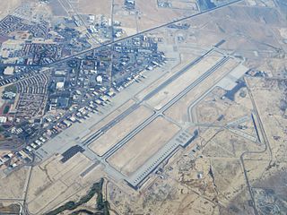
Naval Air Station Fallon or NAS Fallon is the United States Navy's premier air-to-air and air-to-ground training facility. It is located southeast of the city of Fallon in western Nevada. Since 1996, it has been home to the Naval Fighter Weapons School (TOPGUN) taking over from the former NAS Miramar, California, and the surrounding area contains 240,000 acres (97,000 ha) of bombing and electronic warfare ranges. It is also home to the Naval Aviation Warfighting Development Center (NAWDC), which includes TOPGUN, the Carrier Airborne Early Warning Weapons School (CAEWWS) and the Navy Rotary Wing Weapons School. Navy SEAL Combat Search and Rescue (CSAR) training also takes place there.
The United States Navy Strike Fighter Tactics Instructor program, more popularly known as TOPGUN, teaches fighter and strike tactics and techniques to selected naval aviators and naval flight officers, who return to their operating units as surrogate instructors. It began as the United States Navy Fighter Weapons School, established on 3 March 1969, at the former Naval Air Station Miramar in San Diego, California. In 1996, the school was merged into the Naval Strike and Air Warfare Center at Naval Air Station Fallon, Nevada.
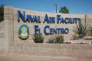
Naval Air Facility El Centro or NAF El Centro is a United States Navy Naval Air Facility located approximately six miles (10 km) northwest of El Centro, in Imperial County, California. NAF El Centro is under the jurisdiction of Navy Region Southwest and serves both as temporary homeport to military units conducting air-to-air and bombing training, and as the winter training home of the Blue Angels.
The Nevada Test and Training Range (NTTR) is one of two military training areas at the Nellis Air Force Base Complex in Nevada and used by the United States Air Force Warfare Center at Nellis Air Force Base. The NTTR land area includes a "simulated Integrated Air Defense System", several individual ranges with 1200 targets, and 4 remote communication sites. The current NTTR area and the range's former areas have been used for aerial gunnery and bombing, for nuclear tests, as a proving ground and flight test area, for aircraft control and warning, and for Blue Flag, Green Flag, and Red Flag exercises.
The Hot Springs Mountains are a range of rocky hills located in Northern Nevada, in Churchill County, between the cities of Fallon, Lovelock, and Fernley. The area was recently volcanically active, is underlain by hot rocks, and is the site of several geothermal electric power plants. It is an arid, rough terrain, uninhabited. These mountains are adjacent to the Lahontan Valley, which contains the Forty Mile Desert, a daunting section of the 19th century California emigrant trail. During the Pleistocene epoch this range of mountains was an island in the now extinct Lake Lahontan.

Tonopah Air Force Base is a Formerly Used Defense Site (FUDS) in the USA that was a Tonopah Basin military installation until shortly after it was designated an Air Force Base in 1948. Two of the runways still in use are maintained by Nye County, Nevada; and World War II building foundations and three hangars of the base remain at the municipal Tonopah Airport.
The History of Nevada as a state began when it became the 36th state on October 31, 1864, after telegraphing the Constitution of Nevada to the Congress days before the November 8 presidential election. Statehood was rushed to help ensure three electoral votes for Abraham Lincoln's reelection and add to the Republican congressional majorities.

The Dixie Valley is an endorheic basin which had plentiful ground water around which ranches were built. Prior to the US Navy TOPGUN school moving from California to Nevada, the valley was purchased in 1995 for $100 million and is used as an electronic warfare range for nearby Fallon Naval Air Station.
During World War II, the United States Army Air Forces (USAAF) established numerous airfields in Nevada for training pilots and aircrews of USAAF fighters and bombers.
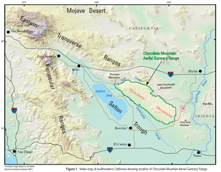
The Chocolate Mountain Aerial Gunnery Range (CMAGR), is a 459,000 acres (1,860 km2) open-area, approximately 20 miles wide, east to west, and 50 miles long, northwest to southeast, with a special use airspace of 700 square miles (1,800 km2) which is used for aerial bombing and live fire aerial gunnery practice. It straddles the northern portion of the Chocolate Mountains to the east of the Salton Sea in Imperial and Riverside Counties, California, with restricted airspace in both California and Arizona. It is under the jurisdiction of the United States Navy and United States Marine Corps, and is closed to the public.

Nevada during World War II was a time of great change that began immediately after the Japanese attack on Pearl Harbor, Hawaii, in December 1941. The population of Nevada grew significantly, largely due to an influx of service men who were stationed at several newly built military bases. The economy also improved as the number of workers steadily increased and new jobs became available.
The Fallon Range Training Complex (FRTC) is a United States Navy military area with four separate training ranges [plus] an integrated air defense system consisting of thirty-seven real or simulated radars throughout the Dixie Valley area" of Nevada. The entire FRTC is also instrumented with a Tactical Aircrew Combat Training System (TACTS).

Army Air Forces Gunnery Schools were World War II organizations for training personnel in the skill of aerial gunnery. The several schools existed at domestic Army Airfields and gunnery ranges.

The Nellis Air Force Base Complex is the southern Nevada military region of federal facilities and lands, e.g., currently and formerly used for military and associated testing and training such as Atomic Energy Commission atmospheric nuclear detonations of the Cold War. The largest land area of the complex is the Nevada Test and Training Range, and numerous Formerly Used Defense Sites remain federal lands of the complex. Most of the facilities are controlled by the United States Air Force and/or the Bureau of Land Management, and many of the controlling units are based at Creech and Nellis Air Force Bases. Initiated by a 1939 military reconnaissance for a bombing range, federal acquisition began in 1940, and McCarren Field became the World War II training area's 1st of 3 Nevada World War II Army Airfields and 10 auxiliary fields. The area's first military unit was initially headquartered in the Las Vegas Federal Building while the WWII Las Vegas Army Airfield buildings were constructed.

In 1954, the state of Nevada was struck by a series of earthquakes that began with three M 6.0+ events in July and August that preceded the M 7.3 mainshock and M 6.9 aftershock, both on December 12. All five earthquakes remain some of the largest in the state, and the largest since the Cedar Mountain earthquake of 1932 and Pleasant Valley event in 1915. The earthquake was felt throughout much of the western United States.

Borrego Valley Maneuver Area also called the Borrego Springs Naval Maneuver Area was an US Army Anti-Aircraft Training Center (AARTC) and a subcamp of Camp Callan. Located near Borrego Springs, California in San Diego County in the Imperial Valley. Opened in March 1942 and in use until August 1944, it was operated by the Western Defense Command. Marine Corps also used the site to train troops in driving army vehicles. The site was picked as it was 400 square miles, 255,840 acres, of barren desert, barren mountains, and badlands. When closed the land returned to the State of California. Built at the site were bombing stations, strafing stations, and rocket targets. Also installed was Anti-Aircraft Artillery for training. First week troop did dry run training and the second week live-fire training. Ammo fired was from .33 to 90mmm. The US Navy trained in the bombing, gunnery, and rocketry. California Institute of Technology help with the rocket training. The air support the base was Naval Outlying Landing Field Clark's Dry Lake, Naval Outlying Field, Ocotillo Dry Lake and Borrego Hotel Naval Outlying Landing Field.

Camp Hydle also called Drakes Bay Range was a large training center during World War II, located at Drakes Bay, on what is now Point Reyes National Seashore on the coast of northern California in the United States. The camp had several training sites: Camp Hydle, Drakes Bay Air to Ground Gunnery Range, Drakes Bay Dive Bombing Target, Camp Murphy's Ranch, Camp Hydle Maneuver Area, and Camp Hydle Skip and Dive Bombing Range. Also at the camp were landing craft training and air sea rescue training. The site was 10,532 acres of Marin County, California land on the West Coast of the United States. The complete area from Stinson Beach to the south and Dillon Beach to the north was called the Point Reyes Gunnery Range at Point Reyes. The Gunnery Range also included: two radar towers, horse stable, two lifeboat Stations, the Point Reyes Lighthouse, lookout towers, and land strafing targets (rake). The dive bomber airplanes came from Hamilton Army Airfield (AAF), Santa Rosa Army Airfield (AAF), and Naval Air Station Alameda (NAS). In addition to Drakes Bay the planes also training using the nearby Abbotts Lagoon, and Tomales Bay. The landing craft training used Limantour Beach and Limantour Spit. Anti-aircraft gun training was important training for the Pacific War. Camp Hydle base was inland 1/2 mile east of Limantour Beach. For gunner training planes towed targets across Drakes Bay. Ships also trained at the base, like the USS Walton and USS Nevada (BB-36). The Navy's Camp Hydle took over the Point Reyes Lifeboat Station during the war. The 50 men at the Station were air sea rescue pilots, dropping rafts to plane crew that landed in the ocean during training. The first troops arrived at the site on December 7, 1941. The site was also used as a coast defense spot, looking out for Japanese subs and ships. Most of the land was leased from Leland Murphy, after the war in 1962, the site became Point Reyes National Seashore.
