Lovelock, Nevada

Last updated

Lovelock, Nevada
2015-04-18 11 52 58 View northwest along Main Street (Nevada State Route 398) near the Central Pacific Railroad Depot in Lovelock, Nevada.jpg
Main Street in Lovelock NV
Pershing County Nevada Incorporated and Unincorporated areas Lovelock Highlighted.svg
USA Nevada location map.svg
Red pog.svg
Lovelock
Location in Nevada
Usa edcp location map.svg
Red pog.svg
Lovelock
Location in the United States
Coordinates: 40°10′48″N118°28′36″W / 40.18000°N 118.47667°W / 40.18000; -118.47667
Country United States
State Nevada
County Pershing
Area
[1]
  Total0.86 sq mi (2.23 km2)
  Land0.86 sq mi (2.23 km2)
  Water0.00 sq mi (0.00 km2)
Elevation
3,980 ft (1,213 m)
Population
 (2020)
  Total1,805
  Density2,096.40/sq mi (809.34/km2)
Time zone UTC-8 (Pacific (PST))
  Summer (DST) UTC-7 (PDT)
ZIP code
89419
Area code 775
FIPS code
GNIS ID
32-43000
0848577
Website www.cityoflovelock.com

Lovelock is the county seat of Pershing County, Nevada, United States, in which it is the only incorporated city.

Contents

It is the namesake of a nearby medium-security men's prison and a Cold War-era gunnery range.

Formerly a stop for settlers on their way to California and later a train depot, the town's economy remains based on farming, mining and increasingly on tourism.

History

The area in which the township of Lovelock was to be established first came to prominence as a midpoint on the Humboldt Trail to California. According to an 1849 description of what were then called the Big Meadows, "This marsh for three miles is certainly the liveliest place that one could witness in a lifetime. There is some two hundred and fifty wagons here all the time. Trains going out and others coming in and taking their places is the constant order of the day. Cattle and mules by the hundreds are surrounding us, in grass to their knees, all discoursing sweet music with the grinding of their jaws.” [2]

A few settlers stopped there to harvest the wild rye growing in the meadows and scythe the hay each fall, which they sold. Arriving there from California in 1866, the English settler George Lovelock (1824–1907) bought the squatters' right for 320 acres (129 ha) and received with it the oldest water rights on the Humboldt River.

Although born in Wales, Lovelock was from an English family of Wiltshire origin that is known to family historians as the Lyneham Line. [3] His brother Daniel moved to Australia—and one of Daniel's sons to New Zealand—so that the relations of the man after whom the Nevada town was named are now widely scattered.

The town's foundation came about with the building of the Central Pacific Railroad through the area in August 1868. George Lovelock provided 85 acres (34 ha) for the site, so the depot was named 'Lovelock's' after him and appears as such on old maps. [4]

Thereafter he put his mining expertise to work and discovered many valuable lodes in the surrounding area, which contributed to increased railway traffic. He also acted as the town's first postmaster and invested in hotels. In particular, he was the first proprietor of the Big Meadows Hotel on Main Street, adjacent to the train station. That was eventually adapted as the Greyhound Bus depot.

By 1900, the town of Lovelock had a school, churches and a business district along what was then called Railway Street—later renamed West Broadway. [5] Also included among the businesses were three weekly newspapers: The Lovelock Tribune, which ran from May 1898 until February 1912; the short-lived Lovelock Standard (April–September 1900); and The Argus (May 1900-Jan 1905). In August 1908 the weekly Lovelock Review was founded, becoming Lovelock Review-Miner in January 1911 and remaining under that name to the present day. [6]

Lovelock was incorporated as a city in 1917. In 1919 it was named the county seat when Pershing County was organized, carved out of the southern part of Humboldt County. Its famous round Court House was built at the end of Main Street, on the former site of a school that had been relocated.

While mining and agriculture were the base of the economy, the community thrived on the state specialty of gambling. It had many casinos and three legalized brothels; all of the latter are now closed.

The town's centenary was celebrated in 1968 with a Frontier Days theme suggested by two of the founder's great-great granddaughters, Elaine Pommerening and Pat Rowe, who had recently moved back to Lovelock. This was part of the more recent emphasis on heritage tourism.

In 1983, old U.S. Route 40 through downtown was bypassed by Interstate 80, which pulled business from the center. In the early 1990s the rail depot closed. Since then, the city has promoted its heritage tourist attractions, emphasizing its historic buildings and organizing special events.

Several mining booms have taken place in the neighboring mountains. These included intensive activity in the Rochester and Seven Troughs areas at the start of the 20th century, and subsequent drilling with more advanced techniques later in Rochester. The Coeur Rochester mine began further open cast mining for silver and gold in 2011. [7] Test drilling for gold continues at Relief Canyon, [8] and diatomite is dug at the Colado Mine. [9]

Geography

Lovelock lies in the Humboldt River Basin, very near the terminus of the river. Some 20 miles outside the town is the Lovelock Native Cave, a horseshoe-shaped cave of about 35 ft width (11 m) and 150 ft length (46 m) where Northern Paiute natives anciently deposited a number of duck decoys and other artifacts. [10]

According to the United States Census Bureau, the city has a total area of 0.9 square miles (2.3 km2), all of it land. It has four differently designed welcome signs with pioneer and Wild West themes placed on its approach roads. At the southern end of town is the 20-acre reservation of the Lovelock Paiute Tribe, which has recently profited from a change in state law to open a marijuana dispensary there. [11]

Climate

According to the Köppen Climate Classification system, Lovelock has a cold desert climate, abbreviated "BWk" on climate maps. The hottest temperature recorded in Lovelock was 112 °F (44 °C) on July 5, 2007, while the coldest temperature recorded was −38 °F (−39 °C) on January 25, 1949. [12]

Climate data for Lovelock, Nevada (Derby Field), 1991–2020 normals, extremes 1948–present
MonthJanFebMarAprMayJunJulAugSepOctNovDecYear
Record high °F (°C)68
(20)
75
(24)
83
(28)
93
(34)
102
(39)
107
(42)
110
(43)
107
(42)
106
(41)
97
(36)
80
(27)
72
(22)
110
(43)
Mean maximum °F (°C)57.9
(14.4)
65.1
(18.4)
74.7
(23.7)
83.2
(28.4)
92.3
(33.5)
100.3
(37.9)
105.0
(40.6)
102.5
(39.2)
96.9
(36.1)
85.2
(29.6)
70.1
(21.2)
60.1
(15.6)
105.5
(40.8)
Mean daily maximum °F (°C)45.2
(7.3)
52.0
(11.1)
61.1
(16.2)
67.5
(19.7)
76.7
(24.8)
87.3
(30.7)
96.1
(35.6)
93.8
(34.3)
84.9
(29.4)
70.7
(21.5)
55.3
(12.9)
44.4
(6.9)
69.6
(20.9)
Daily mean °F (°C)32.6
(0.3)
38.1
(3.4)
44.9
(7.2)
50.5
(10.3)
59.4
(15.2)
68.1
(20.1)
75.9
(24.4)
73.3
(22.9)
64.8
(18.2)
52.5
(11.4)
39.9
(4.4)
31.7
(−0.2)
52.6
(11.5)
Mean daily minimum °F (°C)20.0
(−6.7)
24.2
(−4.3)
28.6
(−1.9)
33.4
(0.8)
42.1
(5.6)
48.9
(9.4)
55.7
(13.2)
52.7
(11.5)
44.8
(7.1)
34.2
(1.2)
24.5
(−4.2)
18.9
(−7.3)
35.7
(2.0)
Mean minimum °F (°C)3.1
(−16.1)
9.4
(−12.6)
13.7
(−10.2)
19.1
(−7.2)
28.2
(−2.1)
36.9
(2.7)
45.6
(7.6)
40.9
(4.9)
30.8
(−0.7)
18.2
(−7.7)
8.5
(−13.1)
1.8
(−16.8)
−2.8
(−19.3)
Record low °F (°C)−38
(−39)
−25
(−32)
−2
(−19)
8
(−13)
17
(−8)
26
(−3)
37
(3)
30
(−1)
20
(−7)
5
(−15)
−3
(−19)
−28
(−33)
−38
(−39)
Average precipitation inches (mm)0.76
(19)
0.55
(14)
0.52
(13)
00.62
(16)
0.86
(22)
0.55
(14)
0.16
(4.1)
0.15
(3.8)
0.29
(7.4)
0.51
(13)
0.50
(13)
0.64
(16)
6.11
(155.3)
Average snowfall inches (cm)3.7
(9.4)
1.5
(3.8)
1.0
(2.5)
0.6
(1.5)
0.2
(0.51)
0.0
(0.0)
0.0
(0.0)
0.0
(0.0)
0.0
(0.0)
0.1
(0.25)
0.7
(1.8)
3.6
(9.1)
11.4
(28.86)
Average precipitation days (≥ 0.01 in)6.14.84.24.44.83.21.81.52.03.03.65.144.5
Average snowy days (≥ 0.1 in)2.60.90.80.20.00.00.00.00.00.00.72.37.5
Source 1: NOAA [13]
Source 2: National Weather Service [12]

Demographics

Historical population
CensusPop.Note
1910 1,104
1920 1,26314.4%
1930 1,2942.5%
1940 1,60424.0%
1950 1,94821.4%
1960 1,571−19.4%
1970 1,6806.9%
1980 2,06923.2%
1990 2,003−3.2%
2000 1,894−5.4%
2010 2,23618.1%
2020 1,805−19.3%
U.S. Decennial Census [14]

As of the census [15] of 2000, there were 2,003 people, 778 households, and 493 families residing in the city. The population density was 2,311.6 inhabitants per square mile (892.5/km2). There were 951 housing units at an average density of 1,097.5 per square mile (423.7/km2). The racial makeup of the city was 76.49% White, 0.80% African American, 7.14% Native American, 0.70% Asian, 0.20% Pacific Islander, 10.03% from other races, and 4.64% from two or more races. Hispanic or Latino of any race were 24.21% of the population.

There were 778 households, out of which 33.5% had children under the age of 18 living with them, 47.8% were married couples living together, 9.3% had a female householder with no husband present, and 36.6% were non-families. 31.5% of all households were made up of individuals, and 12.5% had someone living alone who was 65 years of age or older. The average household size was 2.52 and the average family size was 3.22.

In the city, the population was spread out, with 31.2% under the age of 18, 7.5% from 18 to 24, 27.2% from 25 to 44, 20.9% from 45 to 64, and 13.3% who were 65 years of age or older. The median age was 34 years. For every 100 females, there were 107.8 males. For every 100 females age 18 and over, there were 105.2 males.

The median income for a household in the city was $39,563, and the median income for a family was $44,885. Males had a median income of $38,658 versus $20,371 for females. The per capita income for the city was $17,233. About 9.6% of families and 19.2% of the population were below the poverty line, including 18.9% of those under age 18 and 19.3% of those age 65 or over. The majority rely on agriculture and mining for their income.

Economy

Tourism

Pershing County Court House in Lovelock Pershingcourt.JPG
Pershing County Court House in Lovelock

Among the tourist events figure the I.D.E.S. Portuguese festival in May and what became the annual Frontier Days weekend in July. There are also hot air balloon races (Lovers Aloft, inaugurated in February 2004) and the Lovelock Street Fever car show, begun in June 2007. A major draw is the Lovers Lock Plaza in the shaded area at the back of the Court House where couples symbolise their love by attaching a padlock to an 'endless chain', a practice begun on Valentine's Day, 2005. [16] The following year saw the construction of a dirt-racing track known as the Lovelock Speedway. [17]

Lovelock's heritage buildings include the wooden built Grace Methodist Church on the corner of Cornell Avenue and 8th Street, dating from 1886. It was destroyed by fire in 1922 and the tower was rebuilt without the original spire; in 1983 the church was badly damaged by another fire and was restored again. Marzen House Museum is another Victorian building, built in 1874. The Italianate farmhouse was transported from Big Meadow Ranch in the 1980s and has on its site an assay office, farm machinery sheds, and buildings housing vintage automobiles, while inside it contains 1800s furnishings and a museum, shedding light on the area's history. [18]

The Longhorn Bar beside the tracks on West Broadway is one of the few remaining commercial buildings in typical Nevada style. Not far away is the railroad depot dating from 1880. In 1999 it was presented to the town by the Union Pacific Railroad to be restored and moved to another lot for use as an eatery. This was registered as a historic building in 2004. [19]

The Pershing County Courthouse was built in 1919. Pershing County officials approached Frederic Joseph DeLongchamps, by then the architect of six Nevada courthouses, and asked for a design that would be low in price but distinctive in appearance. As a solution, DeLongchamps designed a round courthouse, patterning it after Thomas Jefferson's library at the University of Virginia campus. The circle-over-hexagon design includes a circular interior hallway and a round courtroom decorated with Corinthian pilasters. A broad, sweeping concrete staircase leads to the main floor of the Beaux-Arts classical structure. Its entrance includes a pedimented portico supported by six Ionic columns. Doric pilasters separate the main story windows. Cream-colored brick and terracotta finish the exterior. A shallow dome crowns the roof and provides the courtroom with a dramatic, soaring ceiling.' [20]

Notable people

Lovelock in the arts

Cowpoke Cafe in Lovelock CowpokeCafeLovelock.jpg
Cowpoke Cafe in Lovelock

Songs

Lovelock, with a population never much more than 2000, will generally be noticed only as a town passed on the way to somewhere else. Thus the debut album of the folk-rock band Center Divide, Lovelock to Winnemucca (1999), takes its title from a desert section of the I-80 highway and the opening track, simply titled “Lovelock”, takes its inspiration from the passing landscape. [21] On the other hand, an interrupted journey is the subject of the Hot Buttered Rum string band's "Limbo in Lovelock" (Live in the Northeast 2007), where a motor breakdown leads to an enforced stop in the town and a visit to the local eatery, the Cowpoke Café. [22] [23]

Poetry and fiction

Lovelock has had a poet of its own in Adrian C. Louis, who was brought up on the small reservation for the Lovelock Paiute Indians there. Even after he moved on, its Indian Cemetery was a point of reference for him to which he often returned in memory:

I'm at that place I grew up to leave.
Alkali-crusted sand waves have drifted against my markers of blood. [24]

Other poems in which the town's name figures record the impressions of passing travellers. They include Shaun T Griffin's broadside, "Rain outside Lovelock, late March” [25] and two titles in the work of Kirk Robertson. "Lovelock to Twin Falls" dwells on abandoned shacks in the desert while “Monday Night, Lovelock” focuses on houses there surrounded by junk. [26]

Stephen Bly's Wild West novel Dangerous Ride Across Humboldt Flats (Crossway Press, 2003) deals with the area along the river before the town was built. In the opening chapters, an orphaned Pony Express rider comes across Trent Lovelock and his family on Humboldt Flats in 1860 and is befriended by them. [27] The author has acknowledged that he had the town's later founder in mind in his fictitious Trent Lovelock. [28]

Another novel, Lovelock, Nevada: an explanation (Booklocker, 2010) by Leslie Hale Roberts, plays another variation on the transient theme, starting with a breakdown in the desert. [29] And a stopover in the town was the subject of Fred Leebron's prize-winning short story “Lovelock”, later adapted into his novel Out West (Doubleday 1996). There an ex-convict staying overnight at a motel picks up a retarded woman and guiltily sees her and her sister off in their car the next morning. [30]

Painting and sculpture

Lovelock's connection with the figurative arts has most often been the result of artists passing through the area and recording something that had caught their eye. One of the earliest such travellers was Thomas Moran, who caught the train south along the recently completed Central Pacific line in 1876 and sketched a thunderstorm over the nearby Humboldt Plain. [31] [32]

For later artists their local work was the result of travelling the country to create a series on a chosen theme. They have included a watercolor in Bethany Lee's 2016 landscapes with a focus on their vegetation, [33] a view in Jessica Joy Jirsa's road sign series from 2018, [34] and a casino restaurant in Jody Litton's continuing series recording the vernacular architecture of California and adjoining states. [35] The landscape photographer John Pfahl also stopped by the town in 1978 to create two works: a shot of the "Lovelock Seed Co." at its southern end [36] and "Lovelock gas station" at the north end. [37]

Other painters were commissioned to create works in the town. Ejnar Hansen was invited by the Federal Art Project to paint a mural in the newly completed post-office building in 1940 and chose the discovery of the Comstock Lode as a local subject. [38] In 1944 the gaming artist Franz Trevors (1907–80) was commissioned to paint six large canvases on Western subjects by a member of the local gambling industry and these were later installed in the casino at Felix's Bank Club on Main Street. For the main part the paintings were based on subjects by Charles Marion Russell but with original details of the artist's own. [39]

Some artists have also chosen to live in Lovelock for a while. Among these was Buck Nimy (1906/11 – 1959), who made black and white drawings of cowboy subjects, some featuring local scenery after he settled in the town about 1940. [40] More recently there has been Maggie Remington, whose speciality is to dig her own pigments from the desert earth to create her abstract designs. [41] Also living there is Don Bridges, who was commissioned to create a memorial for the Emigrant Trail across the Forty-Mile Desert in 2016. Featuring steel reliefs of three oxen and a wagon, it was installed at the 105 freeway exit south of Lovelock, where it was also visible from trains passing nearby. [42]

See also

Related Research Articles

<span class="mw-page-title-main">Nevada</span> U.S. state

Nevada is a landlocked state in the Western region of the United States. It borders Oregon to the northwest, Idaho to the northeast, California to the west, Arizona to the southeast, and Utah to the east. Nevada is the 7th-most extensive, the 32nd-most populous, and the 9th-least densely populated of the U.S. states. Nearly three-quarters of Nevada's people live in Clark County, which contains the Las Vegas–Paradise metropolitan area, including three of the state's four largest incorporated cities. Nevada's capital is Carson City. Las Vegas is the largest city in the state.

<span class="mw-page-title-main">White Pine County, Nevada</span> County in Nevada, United States

White Pine County is a largely rural, mountain county along the central eastern boundary of the U.S. state of Nevada. As of the 2020 census, the population was 9,080. Its county seat is Ely. The name "(Rocky Mountain) white pine" is an old name for the limber pine, a common tree in the county's mountains.

<span class="mw-page-title-main">Washoe County, Nevada</span> County in Nevada, United States

Washoe County is a county in the U.S. state of Nevada. As of the 2020 census, the population was 486,492, making it Nevada's second-most populous county. Its county seat is Reno. Washoe County is included in the Reno, NV Metropolitan Statistical Area.

<span class="mw-page-title-main">Pershing County, Nevada</span> County in Nevada, United States

Pershing County is a county in the U.S. state of Nevada. As of the 2020 census, the population was 6,650. Its county seat is Lovelock. The county was named after army general John J. Pershing (1860–1948). It was formed from Humboldt County in 1919, and the last county to be established in Nevada. The Black Rock Desert, location for the annual Burning Man event, is partially in the county. The county is listed as Nevada Historical Marker 17. The marker is at the courthouse in Lovelock.

<span class="mw-page-title-main">Humboldt County, Nevada</span> County in Nevada, United States

Humboldt County is a county in the U.S. state of Nevada. As of the 2020 Census, the population was 17,285. It is a largely rural county that is sparsely populated with the only major city being Winnemucca which has a population of 8,431. Humboldt County comprises the Winnemucca, NV Micropolitan Statistical Area and serves as an important crossroads in the national transportation network. Interstate 80 travels through the southeastern corner of the county, meeting US 95 in Winnemucca that serves as a primary freight corridor between Northern Nevada and Boise, Idaho and the Interstate 84 freight corridor that links much of the Pacific Northwest. The original transcontinental railway, constructed by the Central Pacific Railroad, reached Humboldt County on September 16, 1868. The Western Pacific Railroad would reach Humboldt County by November 1909, providing two mainline rail links to California and the Eastern United States. Both railroads have since been acquired by the Union Pacific Railroad, who continues to serve the region today.

<span class="mw-page-title-main">Elko County, Nevada</span> County in Nevada, United States

Elko County is a county in the northeastern corner of Nevada, United States. As of the 2020 census, the population was 53,702. Its county seat is Elko. The county was established on March 5, 1869, from Lander County.

<span class="mw-page-title-main">Owyhee County, Idaho</span> County in Idaho, United States

Owyhee County is a county in the southwestern corner of the U.S. state of Idaho. As of the 2020 census, the population was 11,913. The county seat is Murphy, and its largest city is Homedale. In area it is the second-largest county in Idaho, behind Idaho County.

<span class="mw-page-title-main">Susanville, California</span> City in California, United States

Susanville is a city in and is the county seat of Lassen County, California, United States. Susanville is located on the Susan River in the southern part of the county, at an elevation of 4,186 feet (1,276 m). Its population is 16,728 as of the 2020 census, down from 17,947 from the 2010 census. The Susanville urban area contains 8,995 people and 4,233 households.

<span class="mw-page-title-main">Indian Springs, Nevada</span> Unincorporated town in the State of Nevada, United States

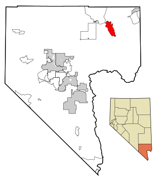
Indian Springs is an unincorporated town and a census-designated place located on U.S. Route 95 next to Creech Air Force Base in northwestern Clark County and southern Nevada.

<span class="mw-page-title-main">Moapa Valley, Nevada</span> Unincorporated town in the State of Nevada, United States

Moapa Valley is an unincorporated town in Clark County, Nevada, United States. As of the 2010 census, it had a population of 6,924. The valley in which the community lies, also named Moapa Valley, is about 40 miles (64 km) long and lies roughly northwest to southeast.

<span class="mw-page-title-main">Wells, Nevada</span> City in Nevada, United States

Wells is a small city in Elko County, in northeast Nevada in the western United States. The population was 1,292 at the 2010 census. Wells is located at the junction of Interstate 80 and U.S. Route 93, approximately 50 miles (80 km) east of Elko and is part of the Elko micropolitan area.

<span class="mw-page-title-main">McDermitt, Nevada and Oregon</span> Unincorporated community in the state of Nevada, United States

McDermitt is an unincorporated community straddling the Nevada–Oregon border, in Humboldt County, Nevada, and Malheur County, Oregon, United States. McDermitt's economy has historically been based on mining, ranching, and farming. The last mining operation closed in 1990, resulting in a steady decline in population.

<span class="mw-page-title-main">Winnemucca, Nevada</span> City in Nevada, United States

Winnemucca is the only incorporated city in, and is the county seat of, Humboldt County, Nevada, United States. As of the 2020 census, the city had a total population of 8,431, up 14.0 percent from the 2010 census figure of 7,396. Interstate 80 passes through the city, where it meets U.S. Route 95.

<span class="mw-page-title-main">Battle Mountain, Nevada</span> Unincorporated town in the State of Nevada, United States

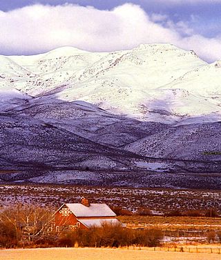
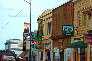
Battle Mountain is an unincorporated town in and the county seat of Lander County, Nevada, United States. The population was 3,705 at the 2020 census. Its primary economic base is gold mining and, to a lesser extent, legalized gambling.

<span class="mw-page-title-main">Tonopah, Nevada</span> Unincorporated town in the state of Nevada, United States

Tonopah is an unincorporated town in, and the county seat of, Nye County, Nevada, United States. Nicknamed the Queen of the Silver Camps for its mining-rich history, it is now primarily a tourism-based resort city, notable for attractions like the Mizpah Hotel and the Clown Motel.

<span class="mw-page-title-main">Golconda, Nevada</span> Census-designated place in Nevada, United States

Golconda is a census-designated place in southeastern Humboldt County, Nevada, United States. As of the 2020 census it has a population of 182. It is located along Interstate 80 on the Humboldt River in the northwestern part of the state. Golconda has a post office, which has been in operation since 1869.

<span class="mw-page-title-main">Imlay, Nevada</span> Unincorporated town in the State of Nevada, United States

Imlay is an unincorporated town in Pershing County, Nevada, United States. It has an elementary school, a general store, a post office, and a trading post. As of the 2010 census, the population was 171.

<span class="mw-page-title-main">History of Nevada</span>

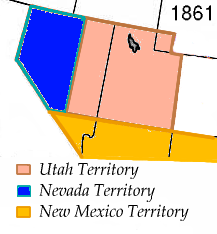
The History of Nevada as a state began when it became the 36th state on October 31, 1864, after telegraphing the Constitution of Nevada to the Congress days before the November 8 presidential election. Statehood was rushed to help ensure three electoral votes for Abraham Lincoln's reelection and add to the Republican congressional majorities.

<span class="mw-page-title-main">Pershing County Courthouse</span> United States historic place

The Pershing County Courthouse in Lovelock, Nevada is a Classical Revival building built in 1920–21. The courthouse's plan is hexagonal with a circular dome over the central circular courtroom. The building was designed by Frederic Joseph DeLongchamps, who had previously designed six other Nevada courthouses. DeLongchamps was involved in the design of a new courthouse for Humboldt County, where the old courthouse had burned. As a result of resentment over assessments for the replacement in Winnemucca, the new Pershing County was created from part of Humboldt County and its seat established in Lovelock. DeLongchamps, as Supervising Architect for the State of Nevada, undertook the new Lovelock courthouse.

The Lovelock Paiute Tribe of the Lovelock Indian Colony is a federally recognized tribe of Northern Paiute Indians in Pershing County, Nevada.

References

  1. "ArcGIS REST Services Directory". United States Census Bureau. Retrieved September 19, 2022.
  2. Quoted in David W. Toll, A brief Description & History of Lovelock, Nevada, available online
  3. Sue Lovelock, From Wiltshire to Nevada – tracing the Lovelock connection, Lovelock Lines 4, January 2006 pp.3-5
  4. An early example is on Mitchell's map of Nevada (1872)
  5. Thomas Wren, A History of the State of Nevada: Its Resources and People, Lewis Publishing Company, 1904 available online
  6. Richard E. Lingenfelter, Karen Rix Gash, The newspapers of Nevada: a history and bibliography, 1854-1979, University of Nevada, 1984 pp.144-7
  7. Coeur.com
  8. Pershing Gold Co.
  9. Mine data online Archived 2013-09-26 at archive.today
  10. "Lovelock Caves, Lovelock Nevada" NevadaBeautiful.com, Retrieved 14 February 2010.
  11. Facebook
  12. 1 2 "NOAA Online Weather Data". National Weather Service. Retrieved September 17, 2022.
  13. "U.S. Climate Normals Quick Access". National Oceanic and Atmospheric Administration. Retrieved September 17, 2022.
  14. "Census of Population and Housing". Census.gov. Retrieved June 4, 2015.
  15. "U.S. Census website". United States Census Bureau . Retrieved January 31, 2008.
  16. "The perfect romantic gift idea. "Locking your love" in Lovelock, Nevada". Lovelock/Pershing County Chamber of Commerce. Retrieved May 17, 2010.
  17. Lovelock, Nevada at Curlie
  18. Online information
  19. Registration online
  20. Julie Nicoletta, Buildings of Nevada, Oxford University Press USA, 2000, ISBN   0-19-514139-3
  21. Murrday Fisher review, All Music
  22. Full lyrics online
  23. There is a performance on the Internet Live Music Archive
  24. "Indian Cemetery: Lovelock, Nevada", Fire Water World, Albuquerque NM, 1989 ( ISBN   0931122511 / 0-931122-51-1)
  25. Black Rock Press (Reno, 2010)
  26. Literary Nevada: Writings from the Silver State, University of Nevada, 2016
  27. The first two chapters are currently available online
  28. “Lovelock Avatars”, Lovelock Lines 6, December 2007 p.7
  29. Detail on Amazon
  30. The Cupola, Gettysburg College
  31. Google image
  32. Thurman Wilkins, Thomas Moran: Artist of the Mountains, University of Oklahoma 1998, p.111
  33. "Mown Hay" on the artist’s website
  34. "Tractor Crossing" on the artist’s website
  35. "Sturgeons" (2007), on the artist’s website
  36. Minneapolis Institute of Arts
  37. Los Angeles Museum of Contemporary Art
  38. Society of Architectural Historians
  39. Lofty.com
  40. Nevada Fine Art
  41. "Lovelock artist uses dirt to paint the earth", Inside Northern Nevada, 17 May, 2017
  42. "Lovelock history monument taking shape", Inside Northern Nevada, 22 February 2017