Fallon, Nevada

Last updated

Fallon
City
2015-04-02 17 24 37 View south along Maine Street in downtown Fallon, Nevada.JPG
Maine Street in Fallon
Nickname: 
The Oasis of Nevada [1]
Churchill County Nevada Incorporated and Unincorporated areas Fallon Highlighted.svg
Location of Fallon and Churchill County, Nevada
Relief map of U.S., Nevada.png
Red pog.svg
Fallon
Location in Nevada
Usa edcp relief location map.png
Red pog.svg
Fallon
Location in the United States
Coordinates: 39°28′22″N118°46′44″W / 39.47278°N 118.77889°W / 39.47278; -118.77889
CountryUnited States
StateFlag of Nevada.svg  Nevada
County Churchill
FoundedJuly 24, 1896;127 years ago (1896-07-24)
Incorporated1908;116 years ago (1908)
Named for Michael Fallon
Government
  MayorKen Tedford (R) [2]
Area
[3]
  Total3.71 sq mi (9.61 km2)
  Land3.71 sq mi (9.61 km2)
  Water0.00 sq mi (0.00 km2)
Elevation
[4]
3,960 ft (1,210 m)
Population
 (2020)
  Total9,327
  Density2,513.34/sq mi (970.33/km2)
Time zone UTC−8 (PST)
  Summer (DST) UTC−7 (PDT)
ZIP codes
89406, 89407, 89496
Area code 775
FIPS code 32-24100
GNIS feature ID0840412 [4]
Website www.cityoffallon.com

Fallon is a city in Churchill County in the U.S. state of Nevada. The population was 9,327 at time of the 2020 census. [5] Fallon is the county seat of Churchill County [6] and is located in the Lahontan Valley. Fallon is known for being home to Naval Air Station Fallon, located southeast of town.

Contents

History

The community was first populated during the California Gold Rush, because multiple would-be Forty-niners stopped after crossing the Carson River. [7]

The town and post office were established on July 24, 1896, in a little shack belonging to Michael Fallon and Eliza Fallon, [8] who operated a ranch at the site. [9] Shortly afterwards, Jim Richards later operated a store near the post office. [10]

The town was officially incorporated in 1908. [10]

Lincoln Highway, the first transcontinental thoroughfare, passes through Fallon from east to west, following the original Pony Express trail. Today it is designated U.S. Highway 50, and eastward from Fallon is popularly known as The Loneliest Road in America, as it passes through only two towns and one small city between Fallon and the Utah state line, over 400 miles distant.

When U.S. Highway 95 (stretching between the U.S. borders with Canada and Mexico) was laid out in the 1930s, the highway north of town met Highway 50 at the northern end of what was then the town center (Maine Street). To avoid forcing traffic through town, there is a four-block "dogleg" on Highway 50 separating the north and south legs of Highway 95.

While the city has expanded greatly over the years, the "old town" area is several blocks of Maine Street. Many of the buildings here date back to the early 20th century, including the historic Fallon Theater, which is still in operation as of 2023.

Naval Air Station Fallon, built in 1942, is southeast of the city center. Since 1996, NAS Fallon has been home to the U.S. Navy's Navy Fighter Weapons School (popularly known as TOPGUN), using several flight training areas and practice ranges in the area.

On June 16, 2019, downtown (Maine Street) Fallon was listed in the National Register of Historic Places. [11]

Geography

Fallon is located in western Churchill County at the geographic coordinates 39°28′22″N118°46′44″W / 39.47278°N 118.77889°W / 39.47278; -118.77889 (39.472792, −118.778826). [12] It is in the Lahontan Valley, a former lakebed into which flows the Carson River, which passes north of the city.

According to the United States Census Bureau, Fallon has a total area of 3.65 square miles (9.45 km2), of which 3.63 square miles (9.41 km2) is land and 0.02 square miles (0.05 km2), or 0.49%, is water. [13]

Demographics

As of the census [14] of 2000, there were 7,536 people, 3,004 households, and 1,877 families residing in the city. The population density was 2,474.1 inhabitants per square mile (955.3/km2). There were 3,336 housing units at an average density of 1,095.2 per square mile (422.9/km2). The racial makeup of the city was 76.5% White, 2.0% African American, 3.0% Native American, 4.7% Asian, 0.3% Pacific Islander, 0.3% from other races, and 3.3% from two or more races. Hispanic or Latino of any race were 9.9% of the population.

There were 3,004 households, out of which 35.4% had children under the age of 18 living with them, 42.7% were married couples living together, 15.3% had a female householder with no husband present, and 37.5% were non-families. 30.7% of all households were made up of individuals, and 11.4% had someone living alone who was 65 years of age or older. The average household size was 2.45 and the average family size was 3.06.

In the city, the population was spread out, with 28.4% under the age of 18, 10.3% from 18 to 24, 29.7% from 25 to 44, 19.4% from 45 to 64, and 12.2% who were 65 years of age or older. The median age was 32 years. For every 100 females, there were 95.7 males. For every 100 females age 18 and over, there were 91.5 males.

The median income for a household in the city was $35,935, and the median income for a family was $41,433. Males had a median income of $35,356 versus $22,818 for females. The per capita income for the city was $16,919. About 9.5% of families and 12.6% of the population were below the poverty line, including 15.6% of those under age 18 and 10.3% of those age 65 or over.

Between 1997 and 2003, the Fallon community experienced an unusually high incidence of childhood leukemia. [15] In response, the U.S. Senate held the Field Hearing Before the Committee on Environment and Public Works during the winter of 2001. Nevada Assemblywoman Merle A. Berman was a participant. According to the minutes of that hearing, on February 14, Berman pressed for answers to ascertain why certain individuals, but not others were selected for the panel of experts chosen to investigate the leukemia clusters and "why the Federal Government was not involved in the testing." And on April 12, Berman obtained this testimony from one of the medical experts in attendance: [16]

[Dr. Thomas Sinks, the associate director for science at the National Center for Environmental Health at the Centers for Disease Control] clarified that nobody ever developed cancer because of chances. There was always a cause, and the challenge in Fallon would be to discover the common denominator among the 11 children. The unifying cause was not yet known, but eventually science would identify the commonality. The probability of the Fallon cluster being a chance event was described by Dr. Sinks as being unlikely.

In 2011, epidemiologists at the University of California, Berkeley theorized that the "space-time patterning" of the leukemia cluster was "consistent with the involvement of an infectious disease," and that a "possible mode of transmission" was "by means of a vector" since mosquitoes were "abundant in Churchill County outside of the urban area of Fallon." [17]

Education

The city is served by the Churchill County School District. Churchill County High School is the main high school and also caters to students in rural areas outside the city. Western Nevada College has a campus in Fallon.

There is a charter school, Oasis Academy. [18]

Fallon has a public library, the Churchill County Library. [19]

Climate

Fallon experiences a cold desert climate, with hot summers and cold winters. Due to Fallon's elevation and aridity, the diurnal temperature variation is quite substantial, especially in the summer months. Fallon's climate is quite dry, due to its location in the Rain Shadow of the Sierra Nevada. Summer days can be hot, but temperatures are cooler than in deserts such as the Mojave, Sonoran, and Chihuahuan deserts, due to Fallon's altitude and higher latitude north of the equator. In the winter, daytime temperatures are usually above freezing, but nights can be bitterly cold. Fallon can experience heavy fog in winter, known as pogonip.

Climate data for Fallon, Nevada, 1991–2020 normals, extremes 1903–present
MonthJanFebMarAprMayJunJulAugSepOctNovDecYear
Record high °F (°C)71
(22)
78
(26)
84
(29)
90
(32)
102
(39)
106
(41)
108
(42)
105
(41)
106
(41)
92
(33)
81
(27)
72
(22)
108
(42)
Mean maximum °F (°C)60.1
(15.6)
65.8
(18.8)
75.2
(24.0)
81.8
(27.7)
90.2
(32.3)
97.3
(36.3)
101.9
(38.8)
99.4
(37.4)
95.1
(35.1)
84.8
(29.3)
71.2
(21.8)
61.8
(16.6)
102.7
(39.3)
Mean daily maximum °F (°C)46.0
(7.8)
52.4
(11.3)
60.7
(15.9)
66.1
(18.9)
74.8
(23.8)
85.1
(29.5)
94.2
(34.6)
91.8
(33.2)
83.3
(28.5)
69.8
(21.0)
55.9
(13.3)
45.2
(7.3)
68.8
(20.4)
Daily mean °F (°C)33.0
(0.6)
37.8
(3.2)
44.6
(7.0)
49.8
(9.9)
58.4
(14.7)
66.9
(19.4)
74.7
(23.7)
72.0
(22.2)
63.6
(17.6)
51.9
(11.1)
40.2
(4.6)
32.1
(0.1)
52.1
(11.2)
Mean daily minimum °F (°C)20.0
(−6.7)
23.3
(−4.8)
28.5
(−1.9)
33.5
(0.8)
41.9
(5.5)
48.7
(9.3)
55.3
(12.9)
52.3
(11.3)
43.9
(6.6)
34.0
(1.1)
24.5
(−4.2)
19.0
(−7.2)
35.4
(1.9)
Mean minimum °F (°C)6.9
(−13.9)
11.7
(−11.3)
15.6
(−9.1)
21.8
(−5.7)
30.0
(−1.1)
36.1
(2.3)
46.0
(7.8)
43.5
(6.4)
33.8
(1.0)
20.9
(−6.2)
12.7
(−10.7)
6.1
(−14.4)
1.9
(−16.7)
Record low °F (°C)−25
(−32)
−27
(−33)
1
(−17)
13
(−11)
20
(−7)
27
(−3)
35
(2)
33
(1)
21
(−6)
6
(−14)
−1
(−18)
−21
(−29)
−27
(−33)
Average precipitation inches (mm)0.63
(16)
0.47
(12)
0.50
(13)
0.45
(11)
0.68
(17)
0.36
(9.1)
0.12
(3.0)
0.15
(3.8)
0.19
(4.8)
0.40
(10)
0.43
(11)
0.39
(9.9)
4.77
(120.6)
Average snowfall inches (cm)1.8
(4.6)
0.7
(1.8)
0.3
(0.76)
0.0
(0.0)
0.0
(0.0)
0.0
(0.0)
0.0
(0.0)
0.0
(0.0)
0.0
(0.0)
0.0
(0.0)
0.3
(0.76)
1.4
(3.6)
4.5
(11.52)
Average precipitation days (≥ 0.01 in)5.04.43.73.44.32.61.51.31.62.82.84.137.5
Average snowy days (≥ 0.1 in)1.00.50.30.10.00.00.00.00.00.00.10.82.8
Source 1: NOAA [20]
Source 2: WRCC [21]
Historical population
CensusPop.Note
1900 741
1910 1,753136.6%
1920 1,7580.3%
1930 1,9118.7%
1940 2,40025.6%
1950 2,73413.9%
1960 2,9598.2%
1970 4,26244.0%
1980 6,43851.1%
1990 7,53617.1%
2000 8,60614.2%
2010 8,6060.0%
2020 9,3278.4%
U.S. Decennial Census [22]

Nuclear weapons testing

Los Alamos National Laboratory, in conjunction with the Department of Defense, conducted an underground nuclear test 28 miles (45 km) southeast of Fallon at 5 p.m. on October 26, 1963. Named Project Shoal, the 12.5-kiloton detonation was part of the Vela Uniform program. The device exploded at a depth of 1,205 feet (367 m) below ground surface. [23] The site is located in Gote Flat in the Sand Springs Range.

Access to the Project Shoal Area is unrestricted. [23] Access to the area is by Highway 50, Nevada Highway 839, then to an improved gravel road to the site.

Notable people

Twin towns

Fallon is twinned with the following towns:

See also

Notes

  1. "About Fallon". Fallon Chamber of Commerce. Retrieved May 16, 2020.
  2. "Mayor's Office – City of Fallon". City of Fallon. Retrieved December 16, 2019.
  3. "ArcGIS REST Services Directory". United States Census Bureau. Retrieved September 19, 2022.
  4. 1 2 U.S. Geological Survey Geographic Names Information System: Fallon, Nevada
  5. "U.S. Census Bureau Quickfacts" . Retrieved May 14, 2022.
  6. "Find a County". National Association of Counties. Archived from the original on May 31, 2011. Retrieved June 7, 2011.
  7. "Fallon | Loneliest Road in America, Nevada's Highway 50" . Retrieved May 28, 2020.
  8. Carlson, Helen S. (1985). Nevada place names : a geographical dictionary. Reno: University of Nevada Press. p. 111. ISBN   978-0-87417-094-8.
  9. Federal Writers' Project (1941). Origin of Place Names: Nevada (PDF). W.P.A. p. 11. Archived (PDF) from the original on April 9, 2018.
  10. 1 2 "All About Fallon!". Fallon Chamber of Commerce. Retrieved May 28, 2020.
  11. Resources, Department of Conservation and Natural. "Downtown Fallon listed in the National Register of Historic Places". www.nevadaappeal.com. Archived from the original on July 17, 2019. Retrieved May 29, 2020.
  12. "US Gazetteer files: 2010, 2000, and 1990". United States Census Bureau. February 12, 2011. Retrieved April 23, 2011.
  13. "Geographic Identifiers: 2010 Demographic Profile Data (G001): Fallon city, Nevada". U.S. Census Bureau, American actfinder. Archived from the original on February 12, 2020. Retrieved October 15, 2014.
  14. "U.S. Census website". United States Census Bureau . Retrieved January 31, 2008.
  15. Francis, Stephen S., Steve Selvin, Wei Yang, et al. "Unusual space-time patterning of the Fallon, Nevada leukemia cluster: Evidence of an infectious etiology," in Journal of Chemico-Biological Interactions, Vol. 196, Issue 3, April 5, 2012, pp. 102–109.
  16. Minutes of the Field Hearing Before the Committee on Environment and Public Works, in "Senate Hearing 107 – 318." Washington, DC: U.S. Government Printing Office, 2002 (retrieved online June 13, 2021).
  17. Francis and Selvin, et al. "Unusual space-time patterning of the Fallon, Nevada leukemia cluster: Evidence of an infectious etiology, Journal of Chemico-Biological Interactions, Vol. 196, Issue 3, 2012.
  18. "Oasis Academy". National Center for Education Statistics . Retrieved April 14, 2023.
  19. "Nevada Public Libraries". PublicLibraries.com. Retrieved June 14, 2019.
  20. "U.S. Climate Normals Quick Access". National Oceanic and Atmospheric Administration. Retrieved on September 7, 2022.
  21. "Period of Record Monthly Climate Summary". Western Regional Climate Center. Retrieved on September 7, 2022
  22. "Census of Population and Housing". Census.gov. Retrieved June 4, 2015.
  23. 1 2 "Remediation Project Shoal Area, Nevada Division of Environmental Protection". Archived from the original on March 23, 2009.
  24. imdb.com
  25. 'Former Assemblyman John Carpenter Dies,' Elko Daily Free Press, Marianne Kobak McKown, November 21, 2016
  26. "St. Louis Lineman Called for Holding Yells, "That's Not Fucking Holding!" into Ref's Open Mic, and then It Gets Weird". December 18, 2011.
  27. Corkill, Bunny. "Luella Kirkbride Drumm." Reno, Nevada: Nevada Women's History Project, retrieved online June 19, 2021.
  28. Louella Drumm, in “Legislature." Reno, Nevada: Nevada State Journal, February 11, 1939, p. 2.

Related Research Articles

<span class="mw-page-title-main">Churchill County, Nevada</span> County in Nevada, United States

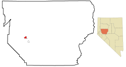
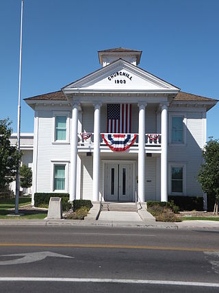
Churchill County is a county in the western U.S. state of Nevada. As of the 2020 census, the population was 25,516. Its county seat is Fallon. Named for Mexican–American War hero brevet Brigadier General Sylvester Churchill, the county was formed in 1861. Churchill County comprises the Fallon, NV Micropolitan Statistical Area. It is in northwestern Nevada. Churchill County is noteworthy in that it owns and operates the local telephone carrier, Churchill County Communications.

<span class="mw-page-title-main">Pershing County, Nevada</span> County in Nevada, United States

Pershing County is a county in the U.S. state of Nevada. As of the 2020 census, the population was 6,650. Its county seat is Lovelock. The county was named after army general John J. Pershing (1860–1948). It was formed from Humboldt County in 1919, and the last county to be established in Nevada. The Black Rock Desert, location for the annual Burning Man event, is partially in the county. The county is listed as Nevada Historical Marker 17. The marker is at the courthouse in Lovelock.

<span class="mw-page-title-main">Custer County, Montana</span> County in Montana, United States

Custer County is a county located in the U.S. state of Montana. As of the 2020 census, the population was 11,867. Its county seat is Miles City. The county was established on June 2, 1865, as one of the nine original counties of the Territory of Montana named Big Horn County, and was renamed on February 16, 1877, in honor of Lieutenant Colonel George Armstrong Custer.

<span class="mw-page-title-main">Nevada County, Arkansas</span> County in Arkansas, United States

Nevada County is a county located in the southwestern part of the U.S. state of Arkansas. As of the 2020 Census, the population was 8,310, less than half of its peak in 1920. The county seat is Prescott. Nevada County is Arkansas's 63rd county, formed during the Reconstruction era on March 20, 1871, from portions of Hempstead, Ouachita and Columbia counties. It was named after the state of Nevada because of the perceived similarity between their physical shapes; the Arkansas county's shape, inverted, roughly follows the same outline as the state's boundary. It is an alcohol prohibition or dry county.

<span class="mw-page-title-main">Cleburne County, Arkansas</span> County in Arkansas, United States

Cleburne County is a county located in the U.S. state of Arkansas. As of the 2020 census, the population was 24,711. The county seat and most populous city is Heber Springs. The county was formed on February 20, 1883, as the last of Arkansas's 75 counties to be formed. It is named for Confederate Major-General Patrick Cleburne. Cleburne is an alcohol prohibition or dry county.

<span class="mw-page-title-main">Phenix City, Alabama</span> City in Alabama, United States

Phenix City is a city in Lee and Russell counties in the U.S. state of Alabama, and the county seat of Russell County. As of the 2020 Census, the population of the city was 38,817.

<span class="mw-page-title-main">Flippin, Arkansas</span> City in Arkansas, United States

Flippin is a city in Marion County, Arkansas, United States. The population was 1,345 at the 2020 census.

<span class="mw-page-title-main">Angels Camp, California</span> City in California, United States

Angels Camp, also known as City of Angels, is the only incorporated city in Calaveras County, California, United States. The population was 3,836 at the 2010 census, up from 3,004 at the 2000 census. It lies at an elevation of 1378 feet.

<span class="mw-page-title-main">Acton, California</span> Census designated place in Los Angeles County, California

Acton is an unincorporated census-designated place in Los Angeles County, California, near the Antelope Valley. According to the 2010 census, Acton had a population of 7,596.

<span class="mw-page-title-main">Potomac, Maryland</span> Census-designated place in Maryland, United States

Potomac is an unincorporated community and census-designated place in Montgomery County, Maryland, United States. As of the 2020 census, it had a population of 47,018. It is named after the nearby Potomac River. A part of the Washington metropolitan area, many Potomac residents work in nearby Washington, D.C., and Northern Virginia.

<span class="mw-page-title-main">South Lake Tahoe, California</span> City in California, United States

South Lake Tahoe is the most populous city in El Dorado County, California, United States, in the Sierra Nevada mountains. The city's population was 21,330 at the 2020 census, down from 21,403 at the 2010 census. The city, along the southern edge of Lake Tahoe, extends about 5 miles (8 km) west-southwest along U.S. Route 50, also known as Lake Tahoe Boulevard. The east end of the city, on the California–Nevada state line right next to the town of Stateline, Nevada, is mainly geared towards tourism, restaurants, hotels, and Heavenly Mountain Resort with the Nevada casinos just across the state line in Stateline. The western end of town is mainly residential, and clusters around "The Y", the intersection of US 50, State Route 89, and the continuation of Lake Tahoe Boulevard after it loses its federal highway designation.

<span class="mw-page-title-main">Gardnerville, Nevada</span> Unincorporated town in the State of Nevada, United States

Gardnerville is an unincorporated town in Douglas County, Nevada, adjacent to the county seat of Minden. The population was 6,211 at the 2020 census.

<span class="mw-page-title-main">Fernley, Nevada</span> City in Nevada, United States

Fernley is a city in Lyon County, Nevada, United States, and part of the Reno–Tahoe-Sparks metropolitan area CSA. The city was incorporated in 2001. The population of the city was 22,895 at the 2020 census, making it the 7th most populous city in Nevada.

<span class="mw-page-title-main">Silver Springs, Nevada</span> Census-designated place in Nevada, United States

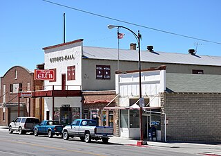
Silver Springs is a census-designated place (CDP) in Lyon County, Nevada, United States at the intersection of US 50 and US 95A. The population was 5,296 at the 2010 census. Lahontan Reservoir, Lahontan State Recreation Area and historic Fort Churchill State Historic Park are all located nearby. The area is served by the Silver Springs Airport.

<span class="mw-page-title-main">McGill, Nevada</span> CDP in Nevada, United States

McGill is a census-designated place (CDP) in White Pine County, Nevada, United States. The population was 1,148 at the 2010 census.

Hume is a town in Allegany County, New York, United States. The population was 2,094 at the 2020 census. The town is on the northern border of Allegany County.

<span class="mw-page-title-main">St. Matthews, South Carolina</span> Town in South Carolina, United States

St. Matthews is a town in Calhoun County, South Carolina, United States. The population was 2,021 at the 2010 census, a decline from 2,107 in 2000. It is the county seat of Calhoun County.

<span class="mw-page-title-main">Jacksboro, Texas</span> Town in Texas, United States

Jacksboro is a city in Jack County, Texas, in the United States. Its population was 4,184 at the 2020 census. U.S. Highways 281 and 380, and Texas State Highways 114 and 199 intersect at Jacksboro, which is the county seat of Jack County.

<span class="mw-page-title-main">Gurney, Wisconsin</span> Town in Wisconsin, United States

Gurney is a town in Iron County, Wisconsin, United States. The population was 158 at the 2000 census. The unincorporated community of Cedar is located in the town.

<span class="mw-page-title-main">Nevada, Iowa</span> City in Iowa, United States

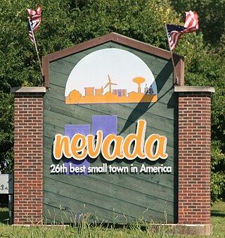
Nevada is a city in, and the county seat of, Story County, Iowa, United States. The population was 6,925 in the 2020 census, an increase from 6,658 in 2000. Nevada is part of the Ames, Iowa Metropolitan Statistical Area, which is a part of the larger Ames-Boone, Iowa Combined Statistical Area. Nevada is the second-most populous city in Story County. The city's name is pronounced differently from the U.S. state of Nevada.

References