Eureka, Nevada

Last updated
Eureka, Nevada
2013-09-19 09 56 20 View of downtown Eureka, Nevada.JPG
Nickname: 
The Friendliest Town on The Loneliest Road [1]
USA Nevada location map.svg
Red pog.svg
Eureka
Location in the state of Nevada
Coordinates: 39°30′42″N115°57′42″W / 39.51167°N 115.96167°W / 39.51167; -115.96167 Coordinates: 39°30′42″N115°57′42″W / 39.51167°N 115.96167°W / 39.51167; -115.96167
CountryUnited States
State Nevada
County Eureka
Area
[2]
  Total1.29 sq mi (3.35 km2)
  Land1.29 sq mi (3.35 km2)
  Water0.00 sq mi (0.00 km2)
Elevation
6,485 ft (1,977 m)
Population
 (2020)
  Total414
  Density320.43/sq mi (123.71/km2)
Time zone UTC−8 (Pacific (PST))
  Summer (DST) UTC−7 (PDT)
ZIP code
89316
FIPS code 32-23900
GNIS feature ID840384

Eureka is an unincorporated town and census-designated places in and the county seat of Eureka County, Nevada, United States. [3] [4] [5] With a population of 480 as of the 2018 American Community Survey 5-Year Estimates, [6] it is by far the largest community in Eureka County. Attractions include the Eureka Opera House (built in 1880 and restored in 1993), Raine’s Market and Wildlife Museum (built 1887), the Jackson House Hotel (built 1877), and the Eureka Sentinel Museum (housed in the 1879 Eureka Sentinel Newspaper Building).

Contents

Eureka is part of the Elko Micropolitan Statistical Area.

Demographics

Historical population
CensusPop.Note
2020 414
U.S. Decennial Census [7]

Geography and climate

Eureka is located at 39°30′42″N115°57′42″W / 39.51159°N 115.961723°W / 39.51159; -115.961723 , [8] in the southern part of Eureka County, at 6,481 feet (1,975 m) in the Diamond Mountains, in a draw on the southern end of Diamond Valley, between Antelope and Newark valleys. At the 2018 American Community Survey 5-Year Estimates, the population of the census-designated place of Eureka was 480, [6] while the total population of Eureka and the surrounding area (Eureka CCD, Eureka County, Nevada) was 1,313. [9]

The town is located along the Lincoln Highway / U.S. Route 50, nicknamed "The Loneliest Road in America": aptly named, as the nearest towns along the highway are Austin (70 mi or 110 km west) and Ely (77 mi or 124 km east). The nearest town is Duckwater, 46 mi (74 km) south.

The climate is typical of the Great Basin: hot and dry with cool mornings in the summer with occasional monsoonal thunderstorms from late July through August; cold and relatively dry in the winter. Temperatures drop to 0 °F or −17.8 °C or lower on an average 3.2 mornings during the winter, though in the severe winter of 1916/1917 this happened twenty-five times. They drop to 32 °F or 0 °C on an average 185.5 mornings, though maximum temperatures top freezing on all but 30.8 days during an average winter. During the summer temperatures rise to 90 °F or 32.2 °C or hotter on 12.5 afternoons, though 100 °F or 37.8 °C has never been reached with the hottest temperature being 110 °F or 43.3 °C on July 22, 1904. Snow accumulations vary from 10 to 30 inches (0.25 to 0.76 m) in mild winters to in excess of 80 inches (2.03 m) in more severe years; in the winter of 1906/1907, more than 150 inches or 3.81 metres of snow fell.

The wettest calendar year has been 1941 with 23.86 inches (606.0 mm) and the driest 2020 with 4.18 inches (106.2 mm), whilst May 1917 with 5.73 inches (145.5 mm) has been the wettest single month. The snowiest month has been March 1902 with 54.0 inches or 1.37 metres of fresh snowfall.

Under the Köppen climate classification, Eureka has a warm-summer humid continental climate (Dfb).

Climate data for Eureka, Nevada, 1991–2020 normals, extremes 1888–present
MonthJanFebMarAprMayJunJulAugSepOctNovDecYear
Record high °F (°C)65
(18)
65
(18)
75
(24)
87
(31)
95
(35)
100
(38)
110
(43)
105
(41)
109
(43)
100
(38)
81
(27)
64
(18)
110
(43)
Mean maximum °F (°C)51.3
(10.7)
54.6
(12.6)
64.8
(18.2)
73.1
(22.8)
80.6
(27.0)
88.9
(31.6)
93.6
(34.2)
91.0
(32.8)
85.9
(29.9)
76.9
(24.9)
65.1
(18.4)
53.1
(11.7)
94.2
(34.6)
Average high °F (°C)37.6
(3.1)
40.2
(4.6)
48.4
(9.1)
54.9
(12.7)
64.7
(18.2)
76.7
(24.8)
85.6
(29.8)
84.1
(28.9)
74.7
(23.7)
61.7
(16.5)
47.7
(8.7)
37.3
(2.9)
59.5
(15.2)
Daily mean °F (°C)27.8
(−2.3)
29.7
(−1.3)
36.4
(2.4)
41.7
(5.4)
50.6
(10.3)
60.6
(15.9)
69.4
(20.8)
68.2
(20.1)
59.4
(15.2)
47.5
(8.6)
36.0
(2.2)
27.3
(−2.6)
46.2
(7.9)
Average low °F (°C)18.0
(−7.8)
19.3
(−7.1)
24.3
(−4.3)
28.6
(−1.9)
36.4
(2.4)
44.4
(6.9)
53.2
(11.8)
52.3
(11.3)
44.1
(6.7)
33.3
(0.7)
24.3
(−4.3)
17.3
(−8.2)
33.0
(0.5)
Mean minimum °F (°C)0.4
(−17.6)
3.3
(−15.9)
10.1
(−12.2)
16.7
(−8.5)
24.5
(−4.2)
32.0
(0.0)
43.8
(6.6)
42.6
(5.9)
31.4
(−0.3)
17.9
(−7.8)
6.8
(−14.0)
0.2
(−17.7)
−4.5
(−20.3)
Record low °F (°C)−26
(−32)
−23
(−31)
−10
(−23)
5
(−15)
10
(−12)
11
(−12)
29
(−2)
30
(−1)
5
(−15)
0
(−18)
−10
(−23)
−21
(−29)
−26
(−32)
Average precipitation inches (mm)0.85
(22)
1.28
(33)
1.34
(34)
1.36
(35)
1.18
(30)
0.49
(12)
0.46
(12)
0.64
(16)
0.78
(20)
0.83
(21)
0.79
(20)
0.86
(22)
10.86
(277)
Average snowfall inches (cm)8.8
(22)
11.9
(30)
7.4
(19)
4.5
(11)
0.8
(2.0)
0.0
(0.0)
0.0
(0.0)
0.0
(0.0)
0.1
(0.25)
0.6
(1.5)
3.4
(8.6)
9.8
(25)
47.3
(119.35)
Average precipitation days (≥ 0.01 in)5.95.95.86.45.42.32.73.13.13.54.66.455.1
Average snowy days (≥ 0.1 in)2.82.41.71.40.50.00.00.00.10.31.53.314.0
Source 1: NOAA [10]
Source 2: National Weather Service [11]

History

The historic Jackson House Hotel, built 1877 JacksonHouseHotelEurekaNV.jpg
The historic Jackson House Hotel, built 1877
The historic Richmond Mine, one of the two major lead-silver mines in Eureka Richmond Mine-Eureka NV.jpg
The historic Richmond Mine, one of the two major lead-silver mines in Eureka

The town was first settled in 1864 by a group of silver prospectors from nearby Austin, who discovered rock containing a silver-lead ore on nearby Prospect Peak. According to tradition, the town was named from an incident when a prospector exclaimed "Eureka!" when he discovered deposits of silver ore. [12] The town became the county seat in 1873, when Eureka County was carved out of adjacent Lander, Elko, and White Pine counties.

Mining, especially for lead, was the town's economic mainstay, [13] as the nearby hillsides ranked as Nevada's second-richest mineral producer, behind western Nevada's Comstock Lode. Two of the largest concerns in Eureka were the Richmond Mining Company and the Eureka Mining Company. These two companies often collided, and in one instance, their litigation reached the U.S Supreme Court. [14] The population boomed, reaching a high of 10,000 by 1878, but shrank as decreasing mine production and changing market conditions led to the closing of mines.

The town was serviced by the narrow gauge Eureka and Palisade Railroad from 1873 to 1938.

Public services

Eureka is served by an all-volunteer fire department, which provides fire protection, rescue, and vehicle rescue services for Eureka and the surrounding areas. In 2009 a new brick and steel fire house was built on Main Street in Eureka. At the time of its building it was the second largest fire house in the state. In addition to being a modern fire fighting facility, it contains a museum of Eureka fire department equipment and vehicles dating back to the 1870s. The fire-museum may be viewed through the large glass windows, or a tour may be taken by contacting a local fireman.

Eureka boasts three parks, a modern enclosed swimming facility, two baseball fields, a track, and football field.

The 1880s Eureka Opera House was re-modeled in recent times and regularly schedules performers. [15]

The 1876 Eureka Court House is both historic and modern. It stands as the functioning governmental and legal center of Eureka County.

Celebrations

July 4, Independence Day, is a huge celebration in Eureka. The Eureka Volunteer Fire Department organizes a parade followed by street events, which require closing central Eureka to vehicular traffic. At 9pm the Eureka Volunteer Fire Department stages a fireworks display.

Education

Eureka County School District is the local school district.

Eureka has a public library, a branch of the Elko-Lander-Eureka County Library System. [16]

Transportation

Notable people

Related Research Articles

<span class="mw-page-title-main">Fallon, Nevada</span> City in Nevada, United States

Fallon is a city in Churchill County in the U.S. state of Nevada. The population was 9,327 at time of the 2020 census. Fallon is the county seat of Churchill County and is located in the Lahontan Valley.

<span class="mw-page-title-main">Minden, Nevada</span> County seat in Nevada, United States

Minden is a census-designated place (CDP) in Douglas County, Nevada, United States. The population was 3,001 at the 2010 census. It is the county seat of Douglas County and is adjacent to the town of Gardnerville. The Douglas campus of the Western Nevada College is located in Minden.

<span class="mw-page-title-main">Elko, Nevada</span> City in Nevada, United States

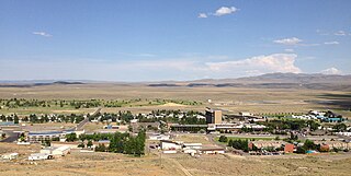
Elko is the largest city in and county seat of Elko County, Nevada, United States. With a 2020 population of 20,564, Elko is currently growing at a rate of 0.31% annually and its population has increased by 11.86% since the 2010 Census, which recorded a population of 18,297. Elko serves as the economic hub of the Ruby Valley, a region with a population of over 55,000. Elko is 21 miles (34 km) from Lamoille Canyon and the Ruby Mountains, dubbed the Swiss Alps of Nevada, providing year round access to recreation including hiking, skiing, hunting, and more than 20 alpine lakes. The city straddles the Humboldt River. Most of the residents in Elko live within the Tree Streets, houses lined with trees and greenery. Spring Creek, Nevada, serves as a bedroom community 6 miles (9.7 km) from the city with a population of 13,805.

<span class="mw-page-title-main">West Wendover, Nevada</span> Place in Nevada, United States

West Wendover is a small city in Elko County, Nevada, United States. The population was 4,410 at the 2010 census. It is part of the Elko micropolitan area. West Wendover is located on the eastern border of Nevada and the western edge of the Great Salt Lake Desert and is contiguous with Wendover, Utah, with which it is sometimes confused. It is home to five casinos and a cannabis dispensary which attract many visitors from neighboring Utah, where both casino gambling and non-medical cannabis are illegal. Interstate 80 runs just north of the cities, while Interstate 80 Business runs through the two cities.

<span class="mw-page-title-main">Battle Mountain, Nevada</span> Unincorporated town in the State of Nevada, United States

Battle Mountain is an unincorporated town in and the county seat of Lander County, Nevada, United States. The population was 3,635 at the 2010 census. Its primary economic base is gold mining and, to a lesser extent, legalized gambling.

<span class="mw-page-title-main">Yerington, Nevada</span> City in Nevada, United States

Yerington is a city in Lyon County, Nevada, United States. The population was 3,048 at the 2010 census. It is the current county seat of Lyon County, with the first county seat having been established at Dayton on November 29, 1861. It is named after Henry M. Yerington, superintendent of the Virginia and Truckee Railroad from 1868 to 1910.

<span class="mw-page-title-main">Tonopah, Nevada</span> Unincorporated town in the State of Nevada, United States

Tonopah is an unincorporated town in, and the county seat of, Nye County, Nevada, United States. It is located at the junction of U.S. Routes 6 and 95, approximately midway between Las Vegas and Reno. In the 2010 census, the population was 2,478. The census-designated place (CDP) of Tonopah has a total area of 16.2 square miles (42 km2), all land.

<span class="mw-page-title-main">Ely, Nevada</span> City in Nevada, United States

Ely is the largest city and county seat of White Pine County, Nevada, United States. Ely was founded as a stagecoach station along the Pony Express and Central Overland Route. In 1906 copper was discovered. Ely's mining boom came later than the other towns along US 50. The railroads connecting the transcontinental railroad to the mines in Austin, Nevada and Eureka, Nevada have long been removed, but the railroad to Ely is preserved as a heritage railway by the Nevada Northern Railway and known as the Ghost Train of Old Ely. As of the 2020 census, the population was 3,924.

<span class="mw-page-title-main">Grants, New Mexico</span> City in New Mexico, United States

Grants is a city in Cibola County, New Mexico, United States. It is located about 78 miles (126 km) west of Albuquerque. The population was 9,163 at the 2020 Census. It is the county seat of Cibola County.

<span class="mw-page-title-main">Custer, South Dakota</span> City in South Dakota, United States

Custer is a city in Custer County, South Dakota, United States. The population was 1,919 at the 2020 census. It is the county seat of Custer County.

<span class="mw-page-title-main">Lead, South Dakota</span> City in South Dakota, United States

Lead is a city in Lawrence County, South Dakota, United States. The population was 2,982 at the 2020 census. Lead is located in western South Dakota, in the Black Hills near the Wyoming state line.

<span class="mw-page-title-main">Republic, Washington</span> City in Washington, United States

Republic is a city in Ferry County, Washington, United States. The population was 1,073 at the 2010 census, a 12.5% increase over the 2000 census. It is the county seat of Ferry County. It was the largest mining camp in the Republic Mining District, and home to the "Hot Air Line" railway.

<span class="mw-page-title-main">Bridgeport, California</span> Census designated place and county seat in California, United States

Bridgeport is an unincorporated community and census-designated place (CDP) in Mono County, California, United States. It is the Mono county seat. The population was 553 at the 2020 census.

<span class="mw-page-title-main">Jackpot, Nevada</span> Census-designated place in Nevada, United States

Jackpot is an unincorporated community and census-designated place (CDP) in Elko County, Nevada, United States. The population was 855 as of the 2020 census. Located less than one mile (1.6 km) from the Idaho border on US 93, Jackpot has been a popular casino gaming destination for residents of Idaho and other neighboring states since its founding.

<span class="mw-page-title-main">Goldfield, Nevada</span> Census-designated place in Nevada, United States

Goldfield is an unincorporated small desert city and the county seat of Esmeralda County, Nevada.

<span class="mw-page-title-main">Pioche, Nevada</span> Unincorporated town in the State of Nevada, United States

Pioche is an unincorporated town in Lincoln County, Nevada, United States, approximately 180 miles (290 km) northeast of Las Vegas. U.S. Route 93 is the main route to Pioche and bypasses the town center just to the east, with Nevada State Route 321 and Nevada State Route 322 providing direct access. Its elevation is 6,060 feet (1,850 m) above sea level. Pioche is the county seat of Lincoln County. Pioche is named after François Louis Alfred Pioche, a San Francisco financier and land speculator originally from France. The town's population was 1,002 at the 2010 census.

<span class="mw-page-title-main">Austin, Nevada</span> Unincorporated town in the State of Nevada, United States

Austin is an unincorporated small town in, and former county seat of, Lander County, Nevada, United States. In 2020, the census-designated place of Austin had a population of 167. It is located on the western slopes of the Toiyabe Range at an elevation of 6,575 feet (2,004 m). U.S. Route 50 passes through the town.

<span class="mw-page-title-main">Montello, Nevada</span> Census-designated place in Nevada, United States

Montello is a census-designated place (CDP) in Elko County, Nevada, United States. It is home to Montello Elementary School, which is part of the Elko County School District. The population of Montello was 50 as of the 2018 American Community Survey. Two small bars and a market/motel selling fuel and sundries comprise the business district. Various cattle ranching operations surround the area.

<span class="mw-page-title-main">Cherry Creek, Nevada</span> Unincorporated community located in the State of Nevada, United States of America

Cherry Creek is a historic mining town located in northern White Pine County, in northeastern Nevada in the western United States. It is a census county division (CCD), with a population at the 2010 census of 72.

<span class="mw-page-title-main">Swansboro, California</span> Unincorporated community in California, United States

Swansboro Country; a subdivision within the community of Mosquito, is a residential area northeast of Placerville, the county seat of El Dorado County, California. The population was approximately 1,000 at the 2010 census. It is part of the Sacramento–Arden-Arcade–Roseville Metropolitan Statistical Area.

References

  1. "The Loneliest Road In America Comes Of Age – Nevada Magazine". Nevada Magazine –. 2016-01-11. Retrieved 2022-08-27.
  2. "ArcGIS REST Services Directory". United States Census Bureau. Retrieved September 19, 2022.
  3. "Eureka County Code - Title 12- Town of Eureka" (PDF). Eureka County. Retrieved 2017-10-16.
  4. "Find a County". National Association of Counties. Archived from the original on 2011-05-31. Retrieved 2011-06-07.
  5. Lambert Molinelli & Co (1982). Eureka and its resources: a complete history of Eureka County, Nevada, containing the United States mining laws, the mining laws of the district, bullion product and other statistics for 1878, and a list of county officers. Reno, Nev.: University of Nevada Press. ISBN   978-0-87417-069-6. LCCN   82004948. OCLC   8346713. Reprint. Originally published: San Francisco : H. Keller, 1879.
  6. 1 2 "Census Geography Profile". U.S. Census Bureau. Retrieved April 10, 2020.
  7. "Census of Population and Housing". Census.gov. Retrieved June 4, 2016.
  8. "US Gazetteer files: 2010, 2000, and 1990". United States Census Bureau. 2011-02-12. Retrieved 2011-04-23.
  9. "Census Search result". U.S. Census Bureau. Retrieved April 10, 2020.
  10. "U.S. Climate Normals Quick Access". National Oceanic and Atmospheric Administration. Retrieved September 13, 2022.
  11. "NOAA Online Weather Data". National Weather Service. Retrieved September 13, 2022.
  12. Federal Writers' Project (1941). Origin of Place Names: Nevada (PDF). W.P.A. p. 34.
  13. "Eureka, Nevada". Western Mining History. Retrieved 2012-03-18.
  14. "Richmond Mining Co. v. Eureka Mining Co., 103 U.S. 839 (1880)". Justia Law. Retrieved 2021-09-09.
  15. "Eureka Opera House". Eureka County, Nevada -- Official Home Page. Retrieved 2012-03-18.
  16. "Nevada Public Libraries". PublicLibraries.com. Retrieved 14 June 2019.
  17. Biographical Directory of the United States Congress