Mackenzie District

Last updated
Mackenzie District
Marko Several Lakes In McKenzie Basin.jpg
Mackenzie DC.PNG
Mackenzie District within the South Island
Coordinates: 43°58′44″S170°27′25″E / 43.979°S 170.457°E / -43.979; 170.457
Country New Zealand
Island South Island
Region Canterbury
Communities
  • Tekapo
  • Twizel
  • Fairlie
Wards
  • Opuha
  • Pukaki
Formed1989
Seat Fairlie
Government
  MayorGraham Smith
  Deputy MayorJames Leslie
   Territorial authority Mackenzie District Council
Area
  Total7,339.23 km2 (2,833.69 sq mi)
  Land7,138.59 km2 (2,756.23 sq mi)
Population
 (June 2022) [1]
  Total5,460
  Density0.74/km2 (1.9/sq mi)
Postcode(s)
Website www.mackenzie.govt.nz OOjs UI icon edit-ltr-progressive.svg

Mackenzie District is a local government district on New Zealand's South Island, administered by the Mackenzie District Council. It is part of the larger Canterbury Region.

Contents

Geography

Principal settlements

The Mackenzie District has four major settlements:

Other smaller settlements include:

Geographical features

Rivers:

Mountains:

Lakes:

Glaciers:

Skifields:

National parks:

Climate

The Mackenzie District has a dry temperate-continental climate with clear, crisp snowy winters and long, hot summers. Autumn is known for being a riot of colour, while spring brings wildflowers blooming throughout the region, including lupins. The warm summer season is from November to February, with temperatures often passing 30 degrees. In the cooler winter season, from June to September, temperatures drop to below 0 degrees Celsius overnight, while sunny winter days average around 8 degrees and regular snowfall. [2]

History

The MacKenzie Basin was named in the 1850s by and after James Mckenzie, a Scottish-origin shepherd and sheep thief, and the name transferred to the modern district.

Demographics

Mackenzie District covers a land area of 7,138.59 km2 (2,756.23 sq mi) [3] and had an estimated population of 5,460 as of June 2022, [1] with a population density of 0.76 people per km2.

Historical population
YearPop.±% p.a.
20063,801    
20134,158+1.29%
20184,866+3.19%
Source: [4]

Mackenzie District had a population of 4,866 at the 2018 New Zealand census, an increase of 708 people (17.0%) since the 2013 census, and an increase of 1,065 people (28.0%) since the 2006 census. There were 1,863 households. There were 2,511 males and 2,352 females, giving a sex ratio of 1.07 males per female. The median age was 40.6 years (compared with 37.4 years nationally), with 801 people (16.5%) aged under 15 years, 978 (20.1%) aged 15 to 29, 2,274 (46.7%) aged 30 to 64, and 810 (16.6%) aged 65 or older.

Ethnicities were 86.4% European/Pākehā, 6.8% Māori, 1.2% Pacific peoples, 8.9% Asian, and 3.4% other ethnicities. People may identify with more than one ethnicity.

The percentage of people born overseas was 24.5, compared with 27.1% nationally.

Although some people objected to giving their religion, 51.7% had no religion, 37.1% were Christian, 1.1% were Hindu, 0.2% were Muslim, 1.2% were Buddhist and 1.5% had other religions.

Of those at least 15 years old, 777 (19.1%) people had a bachelor or higher degree, and 702 (17.3%) people had no formal qualifications. The median income was $33,400, compared with $31,800 nationally. 555 people (13.7%) earned over $70,000 compared to 17.2% nationally. The employment status of those at least 15 was that 2,451 (60.3%) people were employed full-time, 660 (16.2%) were part-time, and 30 (0.7%) were unemployed. [4]

Individual wards
NameArea (km2)PopulationDensity (per km2)HouseholdsMedian ageMedian income
Pukaki Ward5,155.262,6340.5198138.2 years$34,500
Opuha Ward1,983.342,2291.1287942.8 years$31,500
New Zealand37.4 years$31,800
Individual statistical areas in the Mackenzie district (2018 census) [5]
SA2 namePopulationDwellingsMedian ageMedian income
Fairlie88548047.3 years$25,700
Mackenzie Lakes1,18298431.8 years$36,500
Opua1,34763940.0 years$36,600
Twizel1,4551,48546.5 years$31,400

Economy

View near Twizel Golden Season (11) (8114524551).jpg
View near Twizel

In 2012, the Mackenzie District had 850 businesses who employed 1900 full time equivalent staff and generated $190 million dollars in revenue. The economy is based on hydroelectric generation, farming (including aquaculture) and tourism. [6]

Of the 267 farms in the Mackenzie District in 2012, 34% of these were sheep farms, 18% sheep and beef cattle, and 15% beef cattle. Minimal amounts of crop farming occurs in the Mackenzie District, with small amounts of barley (7,733 tonnes) and oats (2,265 tonnes) grown. [6]

A relatively sparsely settled area, the district does have a wide number of farms. However, in the late 2000s, numerous proposals for new farming operations have locals fearing that the agriculture will be transformed from often family-held farms to large agribusiness operations, causing increased local ecologic damage and siphoning off capital overseas. [7]

List of mayors

NameTerm of office
Bruce Scott1989-1992 reference to follow
Neil Anderson1992–2001 [8]
Stan Scorringe2001–2004 [9]
John O'Neill2004–2010 [10]
Claire Barlow2010–2016 [11]
Graham Smith2016–present [12]

Related Research Articles

<span class="mw-page-title-main">South Island</span> One of the two main New Zealand islands

The South Island, also officially named Te Waipounamu, is the larger of the two major islands of New Zealand in surface area, the other being the smaller but more populous North Island. It is bordered to the north by Cook Strait, to the west by the Tasman Sea, and to the south and east by the Pacific Ocean. The South Island covers 150,437 square kilometres (58,084 sq mi), making it the world's 12th-largest island. At low altitude, it has an oceanic climate.

<span class="mw-page-title-main">Otago</span> Region of New Zealand

Otago is a region of New Zealand located in the southern half of the South Island administered by the Otago Regional Council. It has an area of approximately 32,000 square kilometres (12,000 sq mi), making it the country's second largest local government region. Its population was 246,000 in June 2022.

<span class="mw-page-title-main">Mackenzie Basin</span> Area of land in the South Island of New Zealand

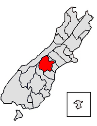
The Mackenzie Basin, popularly and traditionally known as the Mackenzie Country, is an elliptical intermontane basin located in the Mackenzie and Waitaki Districts, near the centre of the South Island of New Zealand. It is the largest such basin in New Zealand. Historically famous mainly for sheep farming, the sparsely populated area is now also a popular tourism destination.

<span class="mw-page-title-main">Waitaki River</span> River in the South Island of New Zealand

The Waitaki River is a large braided river that drains the Mackenzie Basin and runs some 209 kilometres (130 mi) south-east to enter the Pacific Ocean between Timaru and Oamaru on the east coast of the South Island of New Zealand. It starts at the confluence of the Ōhau and Tekapo rivers, now at the head of the artificial Lake Benmore, these rivers being fed by three large glacial lakes, Pukaki, Tekapo, and Ōhau at the base of the Southern Alps. The Waitaki flows through Lake Benmore, Lake Aviemore and Lake Waitaki, these lakes being contained by hydroelectric dams, Benmore Dam, Aviemore Dam and Waitaki Dam. The Waitaki has several tributaries, notably the Ahuriri River and the Hakataramea River. It passes Kurow and Glenavy before entering the Pacific Ocean. The River lends its name the Waitaki District on the south side of the river bank.

<span class="mw-page-title-main">Twizel</span> Town in the South Island of New Zealand

Twizel is the largest town in the Mackenzie District, in the Canterbury Region of the South Island of New Zealand. The town was founded in 1968 to house construction workers on the Upper Waitaki Hydroelectric Scheme. Today, Twizel is a service and tourist town for visitors to the area. It has a resident population of 1,670 ; during the summer, holidaymakers nearly triple the town's population.

<span class="mw-page-title-main">Southland District</span> Territorial authority district in Southland Region, New Zealand

Southland District is a territorial authority district in New Zealand that covers the south of the South Island as well as Stewart Island/Rakiura.

<span class="mw-page-title-main">Waitaki District</span> Territorial authority district in New Zealand

Waitaki District is a territorial authority district that is located in the Canterbury and Otago regions of the South Island of New Zealand. It straddles the traditional border between the two regions, the Waitaki River, and its seat is Oamaru.

<span class="mw-page-title-main">Lake Ōhau</span> Lake in the South Island of New Zealand

Lake Ōhau is a lake in the Mackenzie Basin in the South Island of New Zealand. The Hopkins and Dobson rivers fed into the northern end of Lake Ōhau. These rivers have their headwaters in the Southern Alps / Kā Tiritiri o te Moana. The lake's outflow is the Ōhau River, which travels from the southeast corner of Lake Ōhau and feeds into the Waitaki River hydroelectric project. The Barrier range dominate the western side of Lake Ōhau, while the Ben Ohau range dominates the eastern side of Lake Ōhau. At the northern end of the lake, in between the Hopkins and Dobson rivers, lies the Naumann Range of mountains.

<span class="mw-page-title-main">Lake Pukaki</span> Lake in Canterbury Region, New Zealand

Lake Pukaki is the largest of three roughly parallel alpine lakes running north–south along the northern edge of the Mackenzie Basin on New Zealand's South Island. The others are Lakes Tekapo and Ōhau. All three lakes were formed when the terminal moraines of receding glaciers blocked their respective valleys, forming moraine-dammed lakes. The Alps2Ocean mountain bike trail follows the edge of Lake Pukaki for part of its length.

<span class="mw-page-title-main">Lake Tekapo</span> Lake in the South Island of New Zealand

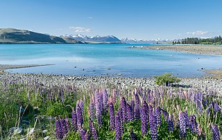
Lake Tekapo is the second-largest of three roughly parallel lakes running north–south along the northern edge of the Mackenzie Basin in the South Island of New Zealand. It covers an area of 83 square kilometres (32 sq mi) and is at an altitude of 710 metres (2,330 ft) above sea level.

<span class="mw-page-title-main">Mount Cook Village</span> Town in New Zealand

Mount Cook Village, officially Aoraki / Mount Cook, is located within New Zealand's Aoraki / Mount Cook National Park at the end of State Highway 80, only 15 kilometres (9.3 mi) south of the summit of the country's highest mountain, also called Aoraki / Mount Cook, in the Southern Alps.

<span class="mw-page-title-main">Lake Tekapo (town)</span> Town in Canterbury, New Zealand

Lake Tekapo is a small township located at the southern end of the lake of the same name in the inland South Island of New Zealand. It had 558 residents according to the 2018 census, being one of five settlements in the sparsely populated Mackenzie Basin.

<span class="mw-page-title-main">Selwyn District</span> Territorial authority district in Canterbury, New Zealand

Selwyn District is a predominantly rural district in central Canterbury, on the east coast of New Zealand's South Island. It is named after the Selwyn River / Waikirikiri, which is in turn named after Bishop George Selwyn, the first Anglican bishop of New Zealand who, in 1843 and 1844, travelled the length of the country by horse, foot, boat and canoe, leaving in his wake a sprinkling of locations that now bear his name.

<span class="mw-page-title-main">Westland District</span> Territorial authority district in West Coast, New Zealand

Westland District is a territorial authority district on the West Coast of New Zealand's South Island. It is administered by the Westland District Council. The district's population is 8,820.

<span class="mw-page-title-main">Queenstown-Lakes District</span> Territorial authority district in Otago, New Zealand

Queenstown-Lakes District, a local government district, is in the Otago Region of New Zealand that was formed in 1986. It is surrounded by the districts of Central Otago, Southland, Westland and Waitaki.

<span class="mw-page-title-main">Clutha District</span> Territorial authority district in Otago, New Zealand

Clutha District is a local government district of southern New Zealand, with its headquarters in the Otago town of Balclutha. Clutha District has a land area of 6,334.47 km2 (2,445.75 sq mi) and an estimated population of 18,650 as of June 2022. Clutha District occupies the majority of the geographical area known as South Otago.

<span class="mw-page-title-main">South Canterbury</span>

South Canterbury is the area of the Canterbury Region of the South Island of New Zealand bounded by the Rangitata River in the north and the Waitaki River to the south. The Pacific Ocean and ridge of the Southern Alps / Kā Tiritiri o te Moana form natural boundaries to the east and west respectively. Though the exact boundaries of the region have never been formalised, the term is used for a variety of government agencies and other entities. It is one of four traditional sub-regions of Canterbury, along with Mid Canterbury, North Canterbury, and Christchurch city.

<span class="mw-page-title-main">Fox Glacier (town)</span> Town in the West Coast Region of New Zealand

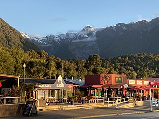
Fox Glacier, called Weheka until the 1940s, is a village on the West Coast of the South Island of New Zealand. The village is close to the eponymous Fox Glacier / Te Moeka o Tuawe.

<span class="mw-page-title-main">The Alps 2 Ocean Cycle Trail</span>

The Alps 2 Ocean Cycle Trail is a cycle trail. This trail is one of the projects of the New Zealand Cycle Trail. The trail extends more than 300 kilometres (190 mi) from Aoraki / Mount Cook to Oamaru on the Pacific Ocean. From west to east, it descends from an altitude of 780 metres (2,560 ft) down to sea level. The trail has both on and off-road sections.

<span class="mw-page-title-main">Waimate District</span> Territorial authority district in Canterbury Region, New Zealand

Waimate District is a territorial authority district located in the Canterbury Region of the South Island of New Zealand. The main town is Waimate, while there are many smaller rural communities dispersed throughout the area. Its boundary to the south is the Waitaki River, to the west Lake Benmore and to the north-east the Pareora River.

References

  1. 1 2 "Subnational population estimates (RC, SA2), by age and sex, at 30 June 1996-2022 (2022 boundaries)". Statistics New Zealand . Retrieved 25 October 2022. (regional councils); "Subnational population estimates (TA, SA2), by age and sex, at 30 June 1996-2022 (2022 boundaries)". Statistics New Zealand . Retrieved 25 October 2022. (territorial authorities); "Subnational population estimates (urban rural), by age and sex, at 30 June 1996-2022 (2022 boundaries)". Statistics New Zealand . Retrieved 25 October 2022. (urban areas)
  2. "Aoraki Mount Cook Mackenzie". mtcooknz.com. Archived from the original on 2009-08-02. Retrieved 2009-07-18.
  3. "ArcGIS Web Application". statsnz.maps.arcgis.com. Retrieved 13 March 2022.
  4. 1 2 "Statistical area 1 dataset for 2018 Census". Statistics New Zealand. March 2020. Mackenzie District (065). 2018 Census place summary: Mackenzie District
  5. "2018 Census place summaries | Stats NZ". www.stats.govt.nz. Retrieved 2020-12-14.
  6. 1 2 Nick Taylor, Simon Harris, Wayne McClintock, Mike Mackay (May 2015). "Upper Waitaki Limit Setting Process: Social-economic Profile of the Waitaki Catchment". Ecan. Retrieved 19 January 2022.{{cite web}}: CS1 maint: multiple names: authors list (link)
  7. Taylor, Gary (2010-02-08). "A national treasure is being squandered". The New Zealand Herald . Retrieved 8 February 2010.
  8. "Health Minister announces DHB deputy chairs". Scoop.co.nz. 21 December 2001.
  9. "Mayoral Election Results 2004 Affecting the Mayors Taskforce For Jobs". Mayors Taskforce for Jobs.
  10. "O'Neill plans family time". Stuff . 8 October 2010.
  11. Watts, Jerram (10 October 2010). "Receptionist becomes Mayor for Mackenzie". Newshub.
  12. "'Exciting times' for new Mackenzie mayor Graham Smith". Stuff . 9 October 2016.