Timaru District

Last updated

Timaru District
Timaru District Council building.jpg
Timaru District Council building
Timaru DC.PNG
Location of the Timaru District within the South Island
Country New Zealand
Island South Island
Region Canterbury
Communities
  • Geraldine
  • Pleasant Point
  • Temuka
Wards
  • Geraldine
  • Pleasant Point-Temuka
  • Timaru
Formed1989
Seat Timaru
Government
   Mayor Nigel Bowen
  Deputy MayorSteve Wills
   Territorial authority Timaru District Council
Area
[1]
  Total2,732.41 km2 (1,054.99 sq mi)
Population
 (June 2023) [2]
  Total48,900
  Density18/km2 (46/sq mi)
Time zone UTC+12 (NZST)
  Summer (DST) UTC+13 (NZDT)
Postcode(s)
Website www.timaru.govt.nz OOjs UI icon edit-ltr-progressive.svg

Timaru District is a local government district on New Zealand's South Island, administered by the Timaru District Council. It is part of the larger Canterbury Region. Timaru district was formed in 1989 from the amalgamation of Timaru City, Geraldine district, Temuka district and Stratham district.

Contents

Geography

The Timaru District is located on the east coast of the South Island and stretches inland as far as the Main Divide. The district has a population of 48,900(June 2023). [2] Timaru is the main town. The next biggest towns in order are Temuka, Geraldine and Pleasant Point. Smaller settlements include Arundel, Cave, Orari and Winchester. The Timaru District Library has branches situated in Timaru, Temuka and Geraldine.

Demographics

Timaru District covers 2,732.41 km2 (1,054.99 sq mi) [1] and had an estimated population of 48,900 as of June 2023, [2] with a population density of 17.9 people per km2.

Historical population
YearPop.±% p.a.
200642,870    
201343,932+0.35%
201846,296+1.05%
Source: [3]

Timaru District had a population of 46,296 at the 2018 New Zealand census, an increase of 2,364 people (5.4%) since the 2013 census, and an increase of 3,426 people (8.0%) since the 2006 census. There were 19,119 households, comprising 22,812 males and 23,481 females, giving a sex ratio of 0.97 males per female. The median age was 44.8 years (compared with 37.4 years nationally), with 8,289 people (17.9%) aged under 15 years, 7,596 (16.4%) aged 15 to 29, 20,280 (43.8%) aged 30 to 64, and 10,128 (21.9%) aged 65 or older.

Ethnicities were 90.4% European/Pākehā, 9.1% Māori, 1.9% Pasifika, 4.4% Asian, and 1.9% other ethnicities. People may identify with more than one ethnicity.

The percentage of people born overseas was 13.4, compared with 27.1% nationally.

Although some people chose not to answer the census's question about religious affiliation, 48.4% had no religion, 40.8% were Christian, 0.3% had Māori religious beliefs, 0.7% were Hindu, 0.2% were Muslim, 0.3% were Buddhist and 1.5% had other religions.

Of those at least 15 years old, 4,887 (12.9%) people had a bachelor's or higher degree, and 9,597 (25.3%) people had no formal qualifications. The median income was $30,300, compared with $31,800 nationally. 5,415 people (14.2%) earned over $70,000 compared to 17.2% nationally. The employment status of those at least 15 was that 18,456 (48.6%) people were employed full-time, 5,751 (15.1%) were part-time, and 951 (2.5%) were unemployed. [3]

Individual wards
NameArea (km2)PopulationDensity (per km2)HouseholdsMedian ageMedian income
Geraldine Ward1,643.635,8353.552,43647.8 years$31,000
Pleasant Point-Temuka Ward832.169,33611.223,81944.5 years$31,200
Timaru Ward256.6231,122121.2812,86444.2 years$29,900
New Zealand37.4 years$31,800

History

Timaru has its origins in a sheep station, The Levels, run by George Rhodes. [4] [5] In 1868, residents petitioned for the town to be established as a borough, and the Timaru Borough Council was proclaimed in 1868. [6]

Economy

Levels Valley, NW of Timaru Levels Valley, South Canterbury 1986.jpg
Levels Valley, NW of Timaru

Venture Timaru is the regional development and tourism organisation.[ citation needed ]

Related Research Articles

<span class="mw-page-title-main">Timaru</span> City in Canterbury, New Zealand

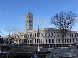
Timaru is a port city in the southern Canterbury Region of New Zealand, located 157 km (98 mi) southwest of Christchurch and about 196 km (122 mi) northeast of Dunedin on the eastern Pacific coast of the South Island. The Timaru urban area is home to 28,900 people, and is the largest urban area in South Canterbury, and the third-largest in the Canterbury Region overall, after Christchurch and Rolleston. The town is the seat of the Timaru District, which includes the surrounding rural area and the towns of Geraldine, Pleasant Point and Temuka, which combined have a total population of 48,900.

<span class="mw-page-title-main">Geraldine, New Zealand</span> Town in Canterbury, New Zealand

Geraldine is a town in the Canterbury region in the South Island of New Zealand. It is about 140 km south of Christchurch, and inland from Timaru, which is 38 km to the south. Geraldine is located on State Highway 79 between the Orari and Hae Hae Te Moana Rivers and 45 kilometres to the east of Fairlie.

<span class="mw-page-title-main">Temuka</span> Town in Canterbury, New Zealand

Temuka is a town on New Zealand's Canterbury Plains, 15 kilometres north of Timaru and 142 km south of Christchurch. It is located at the centre of a rich sheep and dairy farming region, for which it is a service town. It lies on the north bank of the Temuka River, just above its confluence with the Ōpihi River.

<span class="mw-page-title-main">Waitohi</span> Rural area in Canterbury, New Zealand

Waitohi, Waitohi Flat and Upper Waitohi are small farming centres from 5 to 16 km west of Temuka and north of the Opihi river, South Canterbury in New Zealand. They are about 20 km north of Timaru.

Pleasant Point is a small country town in southern Canterbury, New Zealand, some 19 km inland from Timaru, on State Highway 8. It is a service town for the surrounding farming district. One of its main attractions is the heritage railway, the Pleasant Point Museum and Railway, which operates steam locomotives and one of only two Model T Ford railcar replicas in the world. It attracts about 10,000 people a year. For almost one hundred years, the Fairlie branch line railway passed through the town. It closed on 2 March 1968, and the heritage line utilises 2.5 km of track along the branch's old route.

<span class="mw-page-title-main">Cave, New Zealand</span> Town in Canterbury, New Zealand

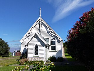
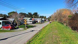
Cave is a town located in the Timaru District, South Island, New Zealand. It is approximately 23 kilometres (14 mi) north-west of Timaru on State Highway 8. St. David's Memorial Church was commissioned by Thomas Burnett and designed by Herbert W. Hall. Built in 1930, it is registered as a category I heritage building with Heritage New Zealand.

<span class="mw-page-title-main">Waddington, New Zealand</span> Settlement in Canterbury, New Zealand

Waddington is a small village located in the Selwyn District of the Canterbury region of New Zealand's South Island, near the Waimakariri Gorge.

<span class="mw-page-title-main">Hinds, New Zealand</span> Town in Canterbury, New Zealand

Hinds is a small town in the Mid-Canterbury region of New Zealand's South Island. It is located on the Canterbury Plains on the south bank of the Hinds River, which reaches the Pacific Ocean between the nearby localities of Longbeach and Lowcliffe. Other localities around Hinds include Ealing to the west, Willowby, Windermere, and Winslow to the northeast, and Eiffelton to the southeast.

Orari is a small town in the South Canterbury region of New Zealand's South Island, roughly midway between Ashburton to the north, and Timaru to the south it is the northernmost town of South Canterbury.

<span class="mw-page-title-main">Winchester, New Zealand</span> Town in Canterbury, New Zealand

Winchester is a small town in the South-Canterbury region of New Zealand's South Island. Winchester is 6.9 kilometres north of Temuka and 51 kilometres southwest of Ashburton.

<span class="mw-page-title-main">Waikuku</span> Town in Canterbury, New Zealand

Waikuku is a small town in the Canterbury region of New Zealand, which sits 28 km north of central Christchurch. Waikuku lies 11.8 km (7.3 mi) south of Leithfield on state highway 1 and 3 km (1.9 mi) north of Woodend. In 1901 there were 86 people resident in Waikuku according to that year's census. Waikuku settlement had a population of 156 people at the time of the 2018 Census. It is popular with both those that commute into work in Christchurch each day and with owners of holiday houses. Waikuku was home to rope and twine works. This business started off using flax from local swamps. It closed in 1987. The nearby sandy beach and pine forests are popular with surfers, swimmers, campers and horse-riders, and the large estuary of the Ashley River hosts many species of birds.

Pareora is a small town in the South Island of New Zealand. It is located close to State Highway 1, which bypasses the western edge of the town, and close to the Pacific Ocean coast, five kilometres north of Saint Andrews and 10 kilometres south of Timaru. The Pareora River reaches the ocean just to the south of the township.

<span class="mw-page-title-main">Ashburton District</span> Territorial authority district in Canterbury, New Zealand

Ashburton District is a territorial authority district in the Canterbury Region of the South Island of New Zealand. It encompasses the town of Ashburton, a number of small towns and settlements and the surrounding rural area, roughly coterminous with Mid Canterbury. The district had a population of 36,800 as of June 2023.

<span class="mw-page-title-main">Whanganui District</span> Territorial authority district in Manawatū-Whanganui, New Zealand

Whanganui District is one of the districts of New Zealand. It includes the city of Whanganui and surrounding areas.

<span class="mw-page-title-main">Saint Andrews, Canterbury</span> Rural settlement in Canterbury, New Zealand

St Andrews is a small town in the south Canterbury region of New Zealand's South Island. It is located on State Highway 1 five kilometres south of Pareora and 17 kilometres south of Timaru. It was linked to Timaru by rail in 1876, and grew after the subdivision of the Pareora Run. It remains a rural service town.

<span class="mw-page-title-main">Ashley, New Zealand</span> Settlement in Canterbury, New Zealand

Ashley is a small town in North Canterbury, in the South Island of New Zealand. It used to have a railway station on the Main North Line that runs through the village.

<span class="mw-page-title-main">Waimate District</span> Territorial authority district in Canterbury Region, New Zealand

Waimate District is a territorial authority district located in the Canterbury Region of the South Island of New Zealand. The main town is Waimate, while there are many smaller rural communities dispersed throughout the area. Its boundary to the south is the Waitaki River, to the west Lake Benmore and to the north-east the Pareora River.

<span class="mw-page-title-main">Takamatua</span> Town in Canterbury, New Zealand

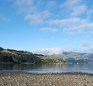
Takamatua, with an initial European name of German Bay, is a small town situated in Akaroa Harbour on Banks Peninsula in New Zealand. The main road to Akaroa passes through this locality. It is 3 kilometres (1.9 mi) north of Akaroa township.

<span class="mw-page-title-main">Selwyn Huts</span> Rural settlement in Canterbury, New Zealand

Selwyn Huts, also called Upper Selwyn Huts, is a rural settlement close to the northern shore of Lake Ellesmere / Te Waihora in the Selwyn District of New Zealand. Lower Selwyn Huts is a smaller settlement 2.8 km further south.

Milford Huts is a bach community in the Timaru district and Canterbury region of New Zealand's South Island. Milford Huts is on the northern side of the Ōpihi River mouth, 7.5 kilometres southeast of Temuka by road.

References

  1. 1 2 "ArcGIS Web Application". statsnz.maps.arcgis.com. Retrieved 13 March 2022.
  2. 1 2 3 "Subnational population estimates (RC, SA2), by age and sex, at 30 June 1996-2023 (2023 boundaries)". Statistics New Zealand . Retrieved 25 October 2023. (regional councils); "Subnational population estimates (TA, SA2), by age and sex, at 30 June 1996-2023 (2023 boundaries)". Statistics New Zealand . Retrieved 25 October 2023. (territorial authorities); "Subnational population estimates (urban rural), by age and sex, at 30 June 1996-2023 (2023 boundaries)". Statistics New Zealand . Retrieved 25 October 2023. (urban areas)
  3. 1 2 "Statistical area 1 dataset for 2018 Census". Statistics New Zealand. March 2020. Timaru District (064). 2018 Census place summary: Timaru District
  4. Pinney, Robert. "George Rhodes". Dictionary of New Zealand Biography . Ministry for Culture and Heritage . Retrieved 10 December 2011.
  5. Cyclopedia Company Limited (1903). "Timaru". The Cyclopedia of New Zealand : Canterbury Provincial District. Christchurch: The Cyclopedia of New Zealand . Retrieved 22 August 2015.
  6. Cyclopedia Company Limited (1903). "Timaru Corporation". The Cyclopedia of New Zealand : Canterbury Provincial District. Christchurch: The Cyclopedia of New Zealand . Retrieved 22 August 2015.