Meriden, Kansas | |
---|---|
Coordinates: 39°11.4′N95°34.1′W / 39.1900°N 95.5683°W [1] | |
Country | United States |
State | Kansas |
County | Jefferson |
Founded | 1872 |
Incorporated | 1891 |
Named for | Meriden, New Hampshire |
Area | |
• Total | 0.77 sq mi (1.98 km2) |
• Land | 0.76 sq mi (1.96 km2) |
• Water | 0.01 sq mi (0.02 km2) |
Elevation | 974 ft (297 m) |
Population | |
• Total | 744 |
• Density | 970/sq mi (380/km2) |
Time zone | UTC-6 (CST) |
• Summer (DST) | UTC-5 (CDT) |
ZIP code | 66512 |
Area code | 785 |
FIPS code | 20-45950 [1] |
GNIS ID | 478474 [1] |
Website | meridenks.com |
Meriden is a city in Jefferson County, Kansas, United States. [1] As of the 2020 census, the population of the city was 744. [3]
Meriden was founded in 1872. [4] It was named by a pioneer settler for his former hometown of Meriden, New Hampshire. [5]
Several streets in Meriden are named after early settlers. Owens Street is named after Albert Owens, whom owned the land that Meriden was originally platted on in 1872. Dawson Street is named after Dr. A. Dawson, who was the first to build a dwelling in Meriden. [6]
The Atchison, Topeka and Santa Fe Railroad originally went through the town. A depot was built in 1873. The railroad officially ceased operations on December 31, 1996. Today, there are little remnants left of the railroad line besides a few old train bridges on private property in the surrounding area. [7]
Meriden is located at 39°11.4′N95°34.1′W / 39.1900°N 95.5683°W (39.1890, -95.5684). [8] According to the United States Census Bureau, the city has a total area of 0.79 square miles (2.05 km2), of which 0.78 square miles (2.02 km2) is land and 0.01 square miles (0.03 km2) is water. [9]
Census | Pop. | Note | %± |
---|---|---|---|
1880 | 103 | — | |
1900 | 433 | — | |
1910 | 467 | 7.9% | |
1920 | 422 | −9.6% | |
1930 | 390 | −7.6% | |
1940 | 421 | 7.9% | |
1950 | 378 | −10.2% | |
1960 | 402 | 6.3% | |
1970 | 472 | 17.4% | |
1980 | 707 | 49.8% | |
1990 | 622 | −12.0% | |
2000 | 706 | 13.5% | |
2010 | 813 | 15.2% | |
2020 | 744 | −8.5% | |
U.S. Decennial Census |
Meriden is part of the Topeka, Kansas Metropolitan Statistical Area.
As of the census [10] of 2010, there were 813 people, 315 households, and 215 families living in the city. The population density was 1,042.3 inhabitants per square mile (402.4/km2). There were 336 housing units at an average density of 430.8 per square mile (166.3/km2). The racial makeup of the city was 96.8% White, 1.4% Native American, 0.2% Asian, and 1.6% from two or more races. Hispanic or Latino of any race were 2.2% of the population.
There were 315 households, of which 43.2% had children under the age of 18 living with them, 43.5% were married couples living together, 15.2% had a female householder with no husband present, 9.5% had a male householder with no wife present, and 31.7% were non-families. 25.7% of all households were made up of individuals, and 9.2% had someone living alone who was 65 years of age or older. The average household size was 2.58 and the average family size was 3.12.
The median age in the city was 33.5 years. 30.3% of residents were under the age of 18; 9.5% were between the ages of 18 and 24; 26.8% were from 25 to 44; 25.3% were from 45 to 64; and 8.2% were 65 years of age or older. The gender makeup of the city was 51.2% male and 48.8% female.
As of the census [11] of 2000, there were 706 people, 260 households, and 198 families living in the city. The population density was 1,986.0 inhabitants per square mile (766.8/km2). There were 279 housing units at an average density of 784.8 per square mile (303.0/km2). The racial makeup of the city was 97.17% White, 0.99% Native American, 0.14% from other races, and 1.70% from two or more races. Hispanic or Latino of any race were 0.99% of the population.
There were 260 households, out of which 45.4% had children under the age of 18 living with them, 54.6% were married couples living together, 16.9% had a female householder with no husband present, and 23.5% were non-families. 20.4% of all households were made up of individuals, and 6.9% had someone living alone who was 65 years of age or older. The average household size was 2.72 and the average family size was 3.14.
In the city, the population was spread out, with 32.4% under the age of 18, 7.8% from 18 to 24, 33.7% from 25 to 44, 16.9% from 45 to 64, and 9.2% who were 65 years of age or older. The median age was 31 years. For every 100 females, there were 101.7 males. For every 100 females age 18 and over, there were 94.7 males.
The median income for a household in the city was $40,221, and the median income for a family was $45,278. Males had a median income of $35,515 versus $25,769 for females. The per capita income for the city was $16,008. About 4.5% of families and 5.9% of the population were below the poverty line, including 7.5% of those under age 18 and 1.8% of those age 65 or over.
The community is served by Jefferson West USD 340 public school district.
Cleghorn is a city in Cherokee County, Iowa, United States. The population was 240 at the 2020 census.
Marcus is a city in Cherokee County, Iowa, United States. The population was 1,079 at the time of the 2020 census.
Meriden is a city in Cherokee County, Iowa, United States. The population was 161 at the time of the 2020 census.
Lone Elm is a city in Anderson County, Kansas, United States. As of the 2020 census, the population of the city was 27.
Isabel is a city in Barber County, Kansas, United States. As of the 2020 census, the population of the city was 68.
Arcadia is a city in northeast Crawford County, Kansas, United States. As of the 2020 census, the population of the city was 254.
Hepler is a city in Crawford County, Kansas, United States. As of the 2020 census, the population of the city was 90.
Walnut is a city in Crawford County, Kansas, United States. As of the 2020 census, the population of the city was 187.
Norcatur is a city in Decatur County, Kansas, United States. As of the 2020 census, the population of the city was 159.
Gove City, more commonly known as Gove, is a city in and the county seat of Gove County, Kansas, United States. As of the 2020 census, the population of the city was 80.
Westwood Hills is a city in Johnson County, Kansas, United States. As of the 2020 census, the population of the city was 400. It is the most densely populated city in the Kansas City Metropolitan Area at 6,240 people per square mile. It borders Kansas City, Missouri.
Penalosa is a city in Kingman County, Kansas, United States. As of the 2020 census, the population of the city was 18.
Meade is a city in and the county seat of Meade County, Kansas, United States. As of the 2020 census, the population of the city was 1,505.
Ness City is a city in and the county seat of Ness County, Kansas, United States. As of the 2020 census, the population of the city was 1,329. Ness City is famous for its four-story Old Ness County Bank Building located downtown, and nicknamed Skyscraper of the Plains.
Colwich is a city in Sedgwick County, Kansas, United States, located northwest of Wichita. As of the 2020 census, the population of the city was 1,455.
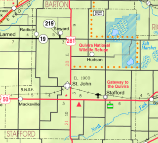
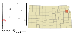
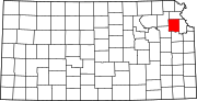
Seward is a city in Stafford County, Kansas, United States. As of the 2020 census, the population of the city was 41.
Mayfield is a city in Sumner County, Kansas, United States. As of the 2020 census, the population of the city was 75.
Washington is a city in, and the county seat of, Washington County, Kansas, United States. As of the 2020 census, the population of the city was 1,071.
Weatherby Lake is a city in Platte County, Missouri and is part of the Kansas City metropolitan area within the United States, which borders Kansas City. The population was 1,723 as of the 2010 census.
Lake Quivira is a city in Johnson and Wyandotte counties in the State of Kansas, and part of the Kansas City Metropolitan Area. As of the 2020 census, the population of the city was 1,014.