Michael S. Van Leesten Memorial Bridge

Last updated
Van Leesten Memorial Bridge
Providence Van Leesten Memorial Bridge.jpg
The bridge as viewed from the southeast
Coordinates 41°49′13″N71°24′18″W / 41.820364°N 71.405104°W / 41.820364; -71.405104
Crosses Providence River
Locale Providence, Rhode Island
Characteristics
Design Footbridge
Total length450 feet (140 m)
History
Construction start2016
Construction end2019
OpenedAugust 9, 2019
Location
Michael S. Van Leesten Memorial Bridge

The Michael S. Van Leesten Memorial Bridge is a footbridge crossing the Providence River located in the city of Providence, Rhode Island. The bridge connects Providence's Fox Point neighborhood to the city's Jewelry District. Originally known as the Providence River Pedestrian Bridge, in July 2020 it was renamed in honor of Michael S. Van Leesten.

Contents

The bridge was built on the piers which supported part of Interstate 195 prior to its relocation.

History

The idea of building a pedestrian bridge on the old Interstate 195 (I-195) piers was suggested in 1999 by a Rhode Island School of Design architecture student. Since money would have had to be spent on demolishing the concrete piers, the rationale was to instead build a simple footbridge with those funds. In 2008, the Rhode Island Department of Transportation (RIDOT) allocated US$2 million towards its construction. A Pedestrian Bridge Design Competition was announced in 2010 by then-Providence Mayor David N. Cicilline and then-DOT director Michael P. Lewis, which was entered by 47 design teams from as far away as Barcelona. inFORM Studio from Detroit was chosen as the winner from among the 11 designs that were displayed at Providence City Hall. [1]

The cost grew dramatically due to several factors. First, that design, chosen by the city under then-Mayor Angel Taveras in 2014, increased the cost to $8 million. In 2016, when it was found that the height of the bridge would have to be raised due to rising sea levels, the estimated cost further inflated to $13 million, and the lowest bid the agency received was $16.9 million. In 2018, construction finally began, while changes in the price of steel and other costs led to the final project expense ballooning to $21.9 million. [2]

Opening ceremony, 9 August 2019 RI politicians at ribbon-cutting ceremony for new pedestrian bridge.jpg
Opening ceremony, 9 August 2019

Per a 2011 agreement, the bridge was transferred from State of Rhode Island to the City of Providence, which will maintain it, for the amount of $1. [3]

The bridge officially opened on August 9, 2019. [2]

The bridge was originally known as the Providence River Pedestrian and Bicycle Bridge. In July 2020 the bridge was named in honor of Michael S. Van Leesten, a local civil rights advocate. [4]

Structure

The bridge is built on the piers of the former stretch of I-195, which was demolished after the Iway was completed. It connects the Fox Point neighborhood on the east end with the Jewelry District on the west end and spans the Providence River. The length is 450 feet (140 m). [5] It contains wooden benches, illuminated tables, built-in chessboards, and stainless-steel railings. The upper deck is made of Brazilian Ipe hardwood, while bluestone steps lead to terraced lower levels containing LED lighting and grass planting. [1] At the time of the opening, a system of parks was being built by the RIDOT as a separate project, which were scheduled to open later in 2019. Enough area of the parks opened with the bridge to allow access by pedestrians and cyclists. [6]

Controversy

View from the Point Street Bridge Providence Pedestrian Bridge viewed from the Point Street Bridge.jpg
View from the Point Street Bridge

The $21.9 million total cost grew from a 2011 state document estimate stipulating the cost was not to exceed $6 million with any overruns to have been paid by the City. [3]

This has drawn criticism amidst the state having the highest percentage of structurally deficient bridges in the US in 2018 according to the American Road and Transportation Builders Association. West Warwick state representative Patricia Morgan has stated, "We are not walking on pedestrian bridges. We are trying to drive to work safely, and we are tired of going over bad roads and bridges. Until we are at least in the middle of the pack with bridges, it is galling. Everyone should be shaking their heads in disbelief." [1] North Smithfield state representative Brian Newberry added, "A pedestrian bridge seems like extra — bells and whistles. It's nice, but it should not be the priority." [1]

Proponents argue that the bridge will become an attraction in itself. Providence’s Department of Planning and Development Director Bonnie Nickerson believes the footbridge will complete a pedestrian circuit that extends north to the Providence Place mall, while WaterFire could continue south to the bridge. She said "It's going to be a spectacular place to be in itself." [1] DOT director Peter Alviti Jr., while admitting that the DOT's current plans and funding would not let the overrun happen now, said "Look, does it add value to the district newly developing in that area? Yes. I can't deny it is artistic and beautiful from an architectural standpoint." [1] Greater City Providence website founder Jef Nickerson concurs, saying that it will provide stunning views, bicycle and pedestrian connections, and waterfront access. "It's not just a piece of infrastructure — it's a destination. It's a worthy investment." [1]

See also

Nuvola apps kcmsystem.svg   Engineeringportal Nuvola apps ksysv square.svg   Transportationportal Flag of Rhode Island.svg  Rhode Islandportal

Related Research Articles

<span class="mw-page-title-main">Interstate 295 (Rhode Island–Massachusetts)</span> Interstate Highway in Rhode Island and Massachusetts

Interstate 295 (I-295), sometimes called the Providence Beltway, is an auxiliary Interstate Highway in the US states of Rhode Island and Massachusetts. It is maintained by the Rhode Island Department of Transportation (RIDOT) and the Massachusetts Department of Transportation (MassDOT). Spanning nearly 27 miles (43 km), it forms a western beltway around Providence, Rhode Island, and is a bypass of I-95 as it travels through the capital city. I-895 was proposed as a complementary eastern beltway to complete a full loop around the city in the 1960s but was ultimately scrapped in the 1980s.

<span class="mw-page-title-main">Interstate 195 (Rhode Island–Massachusetts)</span> Highway in Rhode Island and Massachusetts

Interstate 195 (I-195) is an auxiliary Interstate Highway running a combined 44.55 miles (71.70 km) in the US states of Rhode Island and Massachusetts. It travels from a junction with I-95 in Providence, Rhode Island, east to a junction with I-495 and Massachusetts Route 25 in Wareham, Massachusetts. It runs east–west and passes through the cities of Fall River, Massachusetts, and New Bedford, Massachusetts. The portion of I-195 in East Providence is also known as the East Providence Expressway.

<span class="mw-page-title-main">Rhode Island Route 10</span> State highway in Providence County, Rhode Island, US

Route 10 is a numbered state highway connector in the U.S. state of Rhode Island, traveling along the Huntington Expressway, the first freeway in the state. It connects Route 12 on the Cranston–Providence city line with Interstate 95 (I-95), U.S. Route 6 (US 6), and Memorial Boulevard in downtown Providence, passing just east of the Olneyville area of Providence. It provides an alternate route to I-95 south of downtown, and connects it with the US 6 freeway west from Olneyville towards I-295 and Connecticut.

<span class="mw-page-title-main">Rhode Island Route 37</span> State highway in Rhode Island, US

Route 37 is a state highway running 3.47 miles (5.58 km) in Providence County and Kent County, Rhode Island, United States. A freeway for its entire length, it serves the cities of Cranston and Warwick and is also a major east–west freeway in the Providence metropolitan area, linking T. F. Green Airport with Interstate 295. The western terminus of Route 37 is an at-grade intersection with Natick Avenue in Cranston. The freeway has numbered interchanges with I-295, Rhode Island Route 2, Pontiac Avenue, and I-95 before terminating at a trumpet interchange with U.S. Route 1 in Warwick.

<span class="mw-page-title-main">Rhode Island Route 99</span> State highway in Providence County, Rhode Island, US

Route 99, also known as the Woonsocket Industrial Highway, is a numbered state highway running 2.9 miles (4.7 km) in Providence County, Rhode Island, United States. The route is a nominally north–south freeway for its entire length. Route 99 serves Manville and the Highland Industrial Park, providing freeway access to the city of Woonsocket from Interstate 295 and Rhode Island Route 146, the latter of which bypasses the city. The southern terminus of Route 99 is at a partial interchange with I-295 and Route 146 in Lincoln. The freeway has one interchange in Manville, a village in Lincoln, before terminating at an at-grade intersection with Rhode Island Route 122 in Woonsocket.

<span class="mw-page-title-main">Claiborne Pell Newport Bridge</span> Bridge in Between Jamestown and Newport, Rhode Island

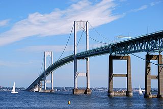
The Claiborne Pell Bridge, commonly known as the Newport Bridge, is a suspension bridge operated by the Rhode Island Turnpike and Bridge Authority that spans the East Passage of the Narragansett Bay in Rhode Island. The bridge, part of RI 138, connects the city of Newport on Aquidneck Island and the Town of Jamestown on Conanicut Island, and is named for longtime Rhode Island U.S. senator Claiborne Pell who lived in Newport. The Pell Bridge is in turn connected to the mainland by the Jamestown Verrazzano Bridge.

<span class="mw-page-title-main">Rhode Island Route 146</span> State highway in Providence County, Rhode Island, US

Route 146 is a 16.24-mile (26.14 km) north-south expressway in the U.S. state of Rhode Island, maintained by the Rhode Island Department of Transportation (RIDOT). Spanning approximately 16 miles (26 km) along a northwest–southeast axis, it links the cities of Providence, Woonsocket, and Worcester, Massachusetts.

<span class="mw-page-title-main">Henderson Bridge (Rhode Island)</span> Bridge in Between Providence and East Providence, Rhode Island

The Henderson Bridge is a bridge in Rhode Island which spans the Seekonk River, and connects the East Side neighborhood of Providence with the Watchemoket and Phillipsdale neighborhoods of East Providence.

<span class="mw-page-title-main">Wickford Junction station</span> Railway station in North Kingstown, RI

Wickford Junction is a commuter rail station located in North Kingstown, Rhode Island, United States. It is the southern terminus of the MBTA Commuter Rail Providence/Stoughton Line and serves as a park and ride location for commuters to Providence, Rhode Island, and Boston, Massachusetts. The station consists of a single high-level side platform on a stub-end siding next to the Northeast Corridor mainline.

<span class="mw-page-title-main">Washington Bridge (Providence, Rhode Island)</span> Bridge in Between Providence and East Providence, Rhode Island

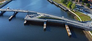
The Washington Bridge is a series of three bridges carrying Interstate 195, US Route 6, US Route 44, and U.S. Route 1A over the Seekonk River connecting India Point in Providence to Watchemoket Square in East Providence, Rhode Island. The historic portion of the bridge dating to 1930 serves as the pedestrian crossing, and bike link to the East Bay Bike Path. The pedestrian span is also a part of the Washington-Rochambeau National Historic Trail.

<span class="mw-page-title-main">U.S. Route 6 in Rhode Island</span> Section of U.S. Highway in Rhode Island, United States

U.S. Route 6 (US 6) is a major east–west road in the U.S. state of Rhode Island. Nationally, the route continues west to Bishop, California, and east to Provincetown, Massachusetts. In western Rhode Island, it forms part of one of several routes between Hartford, Connecticut, and Providence and was planned to be replaced by Interstate 84 (I-84). The part of I-84 that was built, from I-295 to Olneyville, is now part of US 6. At Olneyville, US 6 joins Route 10 and heads east toward Downtown, Providence, where it turns south on I-95 and east on I-195. US 6 splits from I-195 in East Providence, crossing into Massachusetts on Warren Avenue. The whole route of US 6 is a state highway maintained by the Rhode Island Department of Transportation (RIDOT).

<span class="mw-page-title-main">Providence River</span> River in Rhode Island, United States

The Providence River is a tidal river in the U.S. state of Rhode Island. It flows approximately 8 miles (13 km). There are no dams along the river's length, although the Fox Point Hurricane Barrier is located south of downtown to protect the city of Providence from damaging tidal floods.

<span class="mw-page-title-main">East Bay Bike Path</span> Multi-use trail in Rhode Island

The East Bay Bike Path is a 14.5-mile (23.3 km) paved rail trail in Rhode Island. The path begins in Providence and India Point Park, crosses the Seekonk River via the George Redman Linear Park and Washington Bridge and continues southeast to Bristol along the shoreline of Narragansett Bay. The path passes through the city of East Providence, the hamlet of Riverside, and the towns of Barrington and Warren. It is part of the East Coast Greenway, a 3,000-mile system of trails connecting the Canada–US border in Maine to Key West. and provides access to Haines State Park, Brickyard Pond (Barrington), and Colt State Park. It is used annually by 1.1 million people.

<span class="mw-page-title-main">Jewelry District (Providence)</span> Place

The Jewelry District is a neighborhood of Providence, Rhode Island located just southeast of Downtown. The historical path of Interstate 195 delineates the neighborhood's northern border while Interstate 95 and the Providence River define its western, southern and eastern edges.

<span class="mw-page-title-main">Pawtucket/Central Falls station</span> Railway station in Rhode Island, US

Pawtucket/Central Falls station is a commuter rail station in Pawtucket, Rhode Island. It opened for MBTA Commuter Rail Providence/Stoughton Line service on January 23, 2023. The station has two side platforms serving the two tracks of the Northeast Corridor. It is also a hub for RIPTA local bus service.

<span class="mw-page-title-main">Providence, Rhode Island</span> Capital city of Rhode Island, United States

Providence is the capital and most populous city of the U.S. state of Rhode Island. The county seat of Providence County, it is one of the oldest cities in New England, founded in 1636 by Roger Williams, a Reformed Baptist theologian and religious exile from the Massachusetts Bay Colony. He named the area in honor of "God's merciful Providence" which he believed was responsible for revealing such a haven for him and his followers. The city developed as a busy port, as it is situated at the mouth of the Providence River at the head of Narragansett Bay.

<span class="mw-page-title-main">Crook Point Bascule Bridge</span> Bridge in between Providence and East Providence

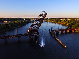
The Crook Point Bascule Bridge is a defunct Scherzer rolling lift railway bridge which spans the Seekonk River, connecting the city of Providence, Rhode Island, to the city of East Providence. Stuck in the open position since its abandonment in 1976, it is known to nearby residents as the "Stuck-Up Bridge" and has become somewhat of a local icon of urban decay.

<span class="mw-page-title-main">Pawtucket River Bridge</span> Bridge in Pawtucket, Rhode Island

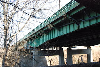
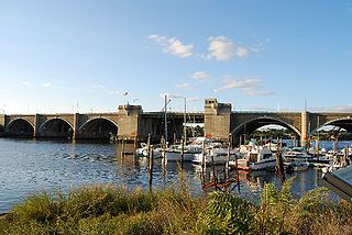
The Pawtucket River Bridge is a twin span, six-lane highway bridge that carries Interstate 95 (I-95) over the Seekonk River in Pawtucket, Rhode Island. The original bridge was built in 1958 and rehabilitated in 1996. The bridge was demolished in 2012-13 and replaced with a new deck arch bridge that was completed in summer 2013. In November 2016, the bridge was officially renamed the James E. Doyle Pawtucket River Bridge in memory of the former mayor of Pawtucket, who died two months earlier.

<span class="mw-page-title-main">2018 Rhode Island elections</span>

A general election was held in the U.S. state of Rhode Island on November 6, 2018. The party primaries for the election occurred on September 12, 2018. All of Rhode Island's executive officers went up for election as well as Rhode Island's Class I U.S. Senate seat and both of Rhode Island's two seats in the United States House of Representatives.

<span class="mw-page-title-main">Mayoral elections in Providence, Rhode Island</span>

Elections are held in Providence, Rhode Island to elect the city's mayor. Such elections are regularly scheduled to be held in United States midterm election years.

References

  1. 1 2 3 4 5 6 7 Fitzpatrick, Edward (3 June 2019). "In a state full of crumbling bridges, $22 million Providence River span stands out". bostonglobe.com. Boston Globe Media Partners, LLC. Boston Globe. Retrieved 28 March 2020.
  2. 1 2 List, Madeleine (10 August 2019). "$21.9 million later, pedestrian bridge opens in downtown Providence". Providence Journal. Gannett Co., Inc. Retrieved 14 April 2020.
  3. 1 2 GoLocalProv News Team (9 August 2019). "State to Turn New $21.9M Pedestrian Bridge Over to Providence for $1, According to 2011 Agreement". www.golocalprov.com. GoLocalProv. Retrieved 5 April 2020.
  4. "City Council's URRP Committee Approves Renaming the Providence Pedestrian Bridge in Memory of Michael S. Van Leesten". City Council News. Providence City Council. Retrieved 15 September 2020.
  5. Miles Montgomery; Brandon Truitt (9 August 2019). "$22M Providence Pedestrian Bridge is officially open; supporters say it's worth every penny". wpri.com. Nexstar Broadcasting, Inc. WPRI. Retrieved 28 March 2020.
  6. Nunes, Rachel (9 August 2019). "New Pedestrian Bridge Opens Across Providence River". patch.com. Patch Media. Patch Providence, RI. Retrieved 28 March 2020.