Minerva Park, Ohio

Last updated

Minerva Park, Ohio
Minerva Lake Road with Cercis canadensis.jpg
Houses on Minerva Lake Road
Minerva Park, Ohio
Coordinates: 40°04′37″N82°56′26″W / 40.07694°N 82.94056°W / 40.07694; -82.94056
Country United States
State Ohio
County Franklin
Area
[1]
  Total0.66 sq mi (1.71 km2)
  Land0.65 sq mi (1.68 km2)
  Water0.01 sq mi (0.03 km2)
Elevation
[2]
850 ft (260 m)
Population
 (2020)
  Total2,009
  Density3,105.10/sq mi (1,199.09/km2)
Time zone UTC-5 (Eastern (EST))
  Summer (DST) UTC-4 (EDT)
FIPS code 39-50862 [3]
GNIS feature ID2399373 [2]
Website www.minervapark.org

Minerva Park is a village in Franklin County, Ohio, United States. The population was 2,009 at the 2020 census.

Contents

The communities of Minerva Park, Bexley, Whitehall, and Valleyview are enclaves of Columbus.

History

Part of the amusement park c. 1897 Columbus, Ohio c. 1897 32.jpg
Part of the amusement park c. 1897
Minerva Lake Minerva Lake in Minerva Park.jpg
Minerva Lake

The village land was founded as a trolley park, also named Minerva Park. The park had a roller coaster, a small zoo, a lake, and other attractions. The park opened July 13, 1895. It operated until 1902, after Olentangy Park outcompeted Minerva Park. For its later history, the site became a graveyard for discarded streetcars. The park's owner unsuccessfully pleaded with Westerville to preserve the amusement park. The site was vacant until 1927, when construction of the subdivision began. The village was incorporated in 1940. [4]

Geography

According to the United States Census Bureau, the village has a total area of 0.52 square miles (1.35 km2), of which 0.51 square miles (1.32 km2) is land and 0.01 square miles (0.03 km2) is water. [5]

Demographics

Historical population
CensusPop.Note
1950 232
1960 1,169403.9%
1970 1,40219.9%
1980 1,61815.4%
1990 1,463−9.6%
2000 1,288−12.0%
2010 1,272−1.2%
2020 2,00957.9%
U.S. Decennial Census [6] 2020 [7]

2010 census

At the 2010 census there were 1,272 people, 539 households, and 352 families living in the village. The population density was 2,494.1 inhabitants per square mile (963.0/km2). There were 565 housing units at an average density of 1,107.8 per square mile (427.7/km2). The racial makeup of the village was 88.5% White, 6.1% African American, 0.3% Native American, 1.7% Asian, 0.1% Pacific Islander, 0.3% from other races, and 3.0% from two or more races. Hispanic or Latino of any race were 3.2%. [8]

Of the 539 households 27.3% had children under the age of 18 living with them, 53.8% were married couples living together, 6.9% had a female householder with no husband present, 4.6% had a male householder with no wife present, and 34.7% were non-families. 28.4% of households were one person and 13.7% were one person aged 65 or older. The average household size was 2.36 and the average family size was 2.86.

The median age in the village was 45.2 years. 19.9% of residents were under the age of 18; 4.7% were between the ages of 18 and 24; 25.2% were from 25 to 44; 31.3% were from 45 to 64; and 19% were 65 or older. The gender makeup of the village was 48.0% male and 52.0% female.

2000 census

At the 2000 census there were 1,288 people, 545 households, and 408 families living in the village. The population density was 2,597.0 inhabitants per square mile (1,002.7/km2). There were 562 housing units at an average density of 1,133.2 per square mile (437.5/km2). The racial makeup of the village was 97.05% White, 0.70% African American, 0.08% Native American, 0.39% Asian, 0.39% from other races, and 1.40% from two or more races. Hispanic or Latino of any race were 0.85%. [3]

Of the 545 households 22.8% had children under the age of 18 living with them, 64.4% were married couples living together, 7.2% had a female householder with no husband present, and 25.0% were non-families. 21.5% of households were one person and 12.1% were one person aged 65 or older. The average household size was 2.36 and the average family size was 2.72.

The age distribution was 19.5% under the age of 18, 4.5% from 18 to 24, 24.1% from 25 to 44, 28.6% from 45 to 64, and 23.2% 65 or older. The median age was 46 years. For every 100 females there were 93.4 males. For every 100 females age 18 and over, there were 91.0 males.

The median household income was $63,875 and the median family income was $67,333. Males had a median income of $47,222 versus $32,130 for females. The per capita income for the village was $29,629. About 0.7% of families and 1.3% of the population were below the poverty line, including 0.9% of those under age 18 and 2.8% of those age 65 or over.

See also

Related Research Articles

<span class="mw-page-title-main">Crawford County, Ohio</span> County in Ohio, United States

Crawford County is a county located in the north central portion of the U.S. state of Ohio. As of the 2020 census, the population was 42,025. Its county seat and largest city is Bucyrus. The county was created in 1820 and later organized in 1836. It was named for Colonel William Crawford, a soldier during the American Revolution. Crawford County comprises the Bucyrus, OH Micropolitan Statistical Area, which is also included in the Mansfield-Ashland-Bucyrus, OH Combined Statistical Area.

<span class="mw-page-title-main">Martin, Michigan</span> Village in Michigan, United States

Martin is a village in southeastern Allegan County in the U.S. state of Michigan. The population was 377 at the 2020 census.

<span class="mw-page-title-main">Port Austin, Michigan</span> Village in Michigan, United States

Port Austin is a village in Huron County in the U.S. state of Michigan. The population was 664 at the 2010 census. The village is within Port Austin Township.

<span class="mw-page-title-main">Stockbridge, Michigan</span> Village in Michigan, United States

Stockbridge is a village in Ingham County in the U.S. state of Michigan. It is located within Stockbridge Township about 36 miles (58 km) southeast from downtown Lansing. The population was 1,218 at the 2010 census.

Minerva Township is a township in Clearwater County, Minnesota, United States. The population was 283 at the 2000 census.

<span class="mw-page-title-main">Miramiguoa Park, Missouri</span> Village in Missouri, United States

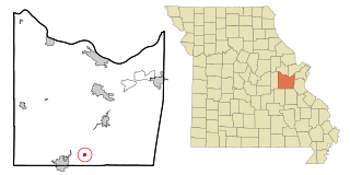
Miramiguoa Park is a village in Franklin County, Missouri, United States. The population was 120 at the 2010 census.

<span class="mw-page-title-main">Pasadena Park, Missouri</span> Village in Missouri, United States

Pasadena Park is a village in St. Louis County, Missouri, United States. The population was 470 at the 2010 census. It is part of the Normandy School District, and is distinct from the city of Pasadena Hills.

<span class="mw-page-title-main">Wilbur Park, Missouri</span> Village in Missouri, United States

Wilbur Park is a village in St. Louis County, Missouri, United States. The population was 439 at the 2020 census.

<span class="mw-page-title-main">Uplands Park, Missouri</span> Village in Missouri, United States

Uplands Park is a village in St. Louis County, Missouri, United States. The population was 445 at the 2010 census. The village is one of many small majority black communities located in the Natural Bridge corridor of mid-St. Louis County, characterized by small homes on small lots.

<span class="mw-page-title-main">Marble Cliff, Ohio</span> Village in Ohio, United States

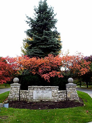
Marble Cliff is a village in Franklin County, Ohio, United States. The population was 634 at the 2020 census.

<span class="mw-page-title-main">Riverlea, Ohio</span> Village in Ohio, United States

Riverlea is a village in Franklin County, Ohio, United States, surrounded by Worthington on its north, south, and east sides, and bordered on the west by the Olentangy River, across which is Columbus. Riverlea was incorporated in 1939, a small community that formed on former farmland. The population was 599 at the 2020 census.

<span class="mw-page-title-main">Valleyview, Ohio</span> Village in Ohio, United States

Valleyview is a village in Franklin County, Ohio, United States. The population was 669 at the 2020 census.

<span class="mw-page-title-main">Terrace Park, Ohio</span> Village in Ohio, United States

Terrace Park is a village in Hamilton County, Ohio, and a suburb of Greater Cincinnati. The population was 2,355 at the 2020 census.

<span class="mw-page-title-main">Gloria Glens Park, Ohio</span> Village in Ohio, United States

Gloria Glens Park is a village in Medina County, Ohio, United States. The population was 369 at the 2020 census.

<span class="mw-page-title-main">Clarksburg, Ohio</span> Village in Ohio, United States

Clarksburg is a village in Ross County, Ohio, United States. The population was 409 at the 2020 census.

<span class="mw-page-title-main">Clinton, Ohio</span> Village in Ohio, United States

Clinton is a village in southwestern Summit County, Ohio, United States. The population was 1,197 at the 2020 Census. It is part of the Akron metropolitan area.

<span class="mw-page-title-main">Avoca, Wisconsin</span> Village in Wisconsin, United States

Avoca is a village in Iowa County, Wisconsin, United States. The population was 637 at the 2010 census. It is part of the Madison Metropolitan Statistical Area. It is named after Avoca in Ireland.

<span class="mw-page-title-main">Wales, Wisconsin</span> Village in Wisconsin, United States

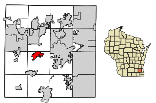
Wales is a village in Waukesha County, Wisconsin, first settled by Welsh immigrants. The population was 2,862 at the time of the 2020 census.

<span class="mw-page-title-main">Minerva, Ohio</span> Village in Ohio, United States

Minerva is a village primarily in Stark and Carroll counties in the U.S. state of Ohio, with a small district in Columbiana County. The population was 3,684 at the 2020 census. Most of Minerva is part of the Canton–Massillon metropolitan area.

<span class="mw-page-title-main">Buckeye Lake, Ohio</span> Village in Ohio, United States

Buckeye Lake is a village in Fairfield and Licking counties in the U.S. state of Ohio. The population was 2,520 at the 2020 census. It is named for Buckeye Lake, a large lake along which the village is built.

References

  1. "ArcGIS REST Services Directory". United States Census Bureau. Retrieved September 20, 2022.
  2. 1 2 U.S. Geological Survey Geographic Names Information System: Minerva Park, Ohio
  3. 1 2 "U.S. Census website". United States Census Bureau . Retrieved January 31, 2008.
  4. "Curious Cbus: How Minerva Park Went from Failed Amusement to Quaint Neighborhood". September 2, 2019.
  5. "US Gazetteer files 2010". United States Census Bureau. Archived from the original on January 25, 2012. Retrieved January 6, 2013.
  6. "Census of Population and Housing". Census.gov. Retrieved June 4, 2015.
  7. "Explore Census Data". data.census.gov.
  8. "U.S. Census website". United States Census Bureau . Retrieved January 6, 2013.