Related Research Articles

Mercer County is a county located in the northwestern portion of the U.S. state of Missouri. As of the 2020 census, the population was 3,538. making it the second-least populous county in Missouri. Its county seat is Princeton. The county was organized February 14, 1845 and named for General John F. Mercer of the Revolutionary War.

Steele County is a county in the U.S. state of Minnesota. As of the 2020 census, the population was 37,406. Its county seat is Owatonna.

Scott County is a county in the U.S. state of Minnesota. As of the 2020 census, the population was 150,928. Its county seat is Shakopee. Shakopee is also the largest city in Scott County, the twenty-third-largest city in Minnesota, and the sixteenth-largest Twin Cities suburb. The county was organized in 1853 and named in honor of General Winfield Scott. Scott County is part of the Minneapolis-St. Paul-Bloomington, MN-WI Metropolitan Statistical Area. It is a member of the Metropolitan Council, and shares many of the council's concerns about responsible growth management, advocating for progressive development concepts such as clustering, open-space design, and the preservation of open space and rural/agricultural land.

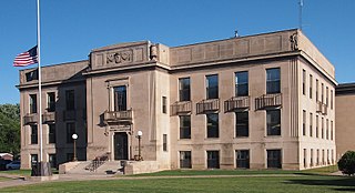
Rice County is a county located in the south central portion of the U.S. state of Minnesota. As of the 2020 census, the population was 67,097. Its county seat is Faribault.

Olmsted County is a county in the U.S. state of Minnesota. As of the 2020 census, the population is 162,847. Its county seat and largest city is Rochester.
Mille Lacs County is a county in the East Central part of the U.S. state of Minnesota. As of the 2020 census, the population was 26,459. Its county seat is Milaca. The county was founded in 1857, and its boundary was expanded in 1860.

Faribault County is a county in the U.S. state of Minnesota. As of the 2020 census, the population was 13,921. Its county seat is Blue Earth.

Cottonwood County is a county in the U.S. state of Minnesota. As of the 2020 census, the population was 11,517. Its county seat is Windom.

Carver County is a county in the U.S. state of Minnesota. The county is mostly farmland and wilderness with many unincorporated townships. As of the 2020 census, the population was 106,922. Its county seat is Chaska. Carver County is named for explorer Jonathan Carver, who in 1766–67, traveled from Boston to the Minnesota River and wintered among the Sioux near the site of New Ulm. Carver County is part of the Minneapolis-St. Paul-Bloomington, MN-WI Metropolitan Statistical Area.

Aitkin County is a county in the U.S. state of Minnesota. As of the 2020 census, the population was 15,697. Its county seat is Aitkin. Part of the Mille Lacs Indian Reservation is in the county. The county was created in 1857 and organized in 1871.
Hersey Township is a township in Nobles County, Minnesota, United States. The population was 257 at the 2000 census.
Wheeling Township is a rural township in Rice County, Minnesota, United States. The population was 541 at the 2000 census.

Blaine is a suburban city in Anoka and Ramsey counties in the State of Minnesota, United States. Once a rural town, Blaine's population has increased significantly in the last 60 years. For several years, Blaine led the Twin Cities metro region in new home construction. The population was 70,222 at the 2020 census. The city is located mainly in Anoka County, and is part of the Minneapolis–Saint Paul metropolitan area.

The Minnesota House of Representatives is the lower house of the Legislature of the U.S. state of Minnesota. There are 134 members, twice as many as the Minnesota Senate. Floor sessions are held in the north wing of the State Capitol in Saint Paul. Offices for members and staff, as well as most committee hearings, are located in the nearby State Office Building.
The Minnesota Senate is the upper house of the Legislature of the U.S. state of Minnesota. At 67 members, half as many as the Minnesota House of Representatives, it is the largest upper house of any U.S. state legislature. Floor sessions are held in the west wing of the State Capitol in Saint Paul. Committee hearings, as well as offices for senators and staff, are located north of the State Capitol in the Minnesota Senate Building. Each member of the Minnesota Senate represents approximately 80,000 constituents.
The United States District Court for the District of Minnesota is the federal district court whose jurisdiction is the state of Minnesota. Its two primary courthouses are in Minneapolis and Saint Paul. Cases are also heard in the federal courthouses of Duluth and Fergus Falls.

The Cooper neighborhood resides along the west shore of the Mississippi River in south Minneapolis. It is bound by 34th St. E. on the south, 38th Ave. S. on the west, 27th St. E. on the north, and the river gorge to the east. Bordering neighborhoods are Seward to the north, Longfellow to the west, and Howe to the south. St. Paul's Merriam Park neighborhood is just across the Mississippi River to the east.
Minnesota's 6th congressional district includes most or all of Benton, Carver, Sherburne, Stearns, Wright, Anoka, and Washington counties. Many of the Twin Cities' northern and northwestern suburbs are included within the boundaries of this district, such as Blaine, Andover, Ramsey, St. Michael-Albertville, Elk River, Lino Lakes, Forest Lake, Otsego, Buffalo, Anoka, Ham Lake, Hugo, Monticello, Waconia, East Bethel, and Big Lake. The St. Cloud Area is the other major center of population for the district, including the cities of St. Cloud, Sartell, and Sauk Rapids. The district is Republican-leaning with a Cook Partisan Voting Index (CPVI) of R+12. It is currently represented by Republican Tom Emmer.
Minnesota's 3rd congressional district encompasses the suburbs of Hennepin, Carver, and Anoka counties to the west, south, and north of Minneapolis. The district, which is mostly suburban in character, includes a few farming communities on its far western edge and also inner-ring suburban areas on its eastern edge. The district includes the blue collar cities of Brooklyn Park and Coon Rapids to the north-east, middle-income Bloomington to the south, and higher-income Eden Prairie, Edina, Maple Grove, Plymouth, Minnetonka, and Wayzata to the west. Democrat Dean Phillips currently represents the district in the U.S. House of Representatives, after defeating incumbent Republican Erik Paulsen in the November 2018 mid-term elections.

Saint Anthony West is a neighborhood in the Northeast community of Minneapolis, Minnesota