Hyderabad is the capital and largest city of the Indian state of Telangana. It occupies 650 km2 (250 sq mi) on the Deccan Plateau along the banks of the Musi River, in the northern part of Southern India. With an average altitude of 542 m (1,778 ft), much of Hyderabad is situated on hilly terrain around artificial lakes, including the Hussain Sagar lake, predating the city's founding, in the north of the city centre. According to the 2011 Census of India, Hyderabad is the fourth-most populous city in India with a population of 6.9 million residents within the city limits, and has a population of 9.7 million residents in the metropolitan region, making it the sixth-most populous metropolitan area in India. With an output of US$74 billion, Hyderabad has the fifth-largest urban economy in India.
Raj Bhavan is the official residence of the governor of Telangana located in the city of Hyderabad, India. It is located at Somajiguda adjacent to Hussain Sagar lake.

Telangana is a state in India situated in southern part of the Indian peninsula on the high Deccan Plateau. It is the eleventh-largest state and the twelfth-most populated state in India as per 2011 census. On 2 June 2014, the area was separated from the northwestern part of United Andhra Pradesh as the newly formed state of Telangana, with Hyderabad as its capital.
Secunderabad, also spelled as Sikandarabad, is a twin city of Hyderabad and one of the six zones of the Greater Hyderabad Municipal Corporation (GHMC) in the Indian state of Telangana. It is the headquarters of the South Central Railway zone. Named after the Mir Akbar Ali Khan Sikander Jah, Asaf Jah III, Nizam of the Asaf Jahi dynasty, Secunderabad was established in 1806 as a British cantonment. Although both the cities are together referred to as the twin cities, Hyderabad and Secunderabad have different histories and cultures, with Secunderabad having developed directly under British rule until 1948, and Hyderabad as the capital of the Nizams' princely state of Hyderabad. Since 1956, the city has housed the Rashtrapati Nilayam, the winter office of the president of India.

Nizamabad is a city in the Indian state of Telangana. It is governed by municipal corporation and is the headquarters of the Nizamabad district. Although previously part of Hyderabad State and then Andhra Pradesh state, Nizamabad became a part of the newly formed state of Telangana by the Andhra Pradesh Reorganisation Act, 2014. It is located about 186 kilometres (116 mi) north of the state capital, Hyderabad.

Mir Osman Ali Khan, Asaf Jah VII was the last Nizam (ruler) of the Princely State of Hyderabad, the largest princely state in British India. He ascended the throne on 29 August 1911, at the age of 25 and ruled the Kingdom of Hyderabad between 1911 and 1948, until India annexed it. He was styled as His Exalted Highness (H.E.H) the Nizam of Hyderabad, and was widely considered one of the world's wealthiest people of all time. With some estimate placing his wealth at 2% of U.S. GDP, his portrait was on the cover of Time magazine in 1937. As a semi-autonomous monarch, he had his mint, printing his currency, the Hyderabadi rupee, and had a private treasury that was said to contain £100 million in gold and silver bullion, and a further £400 million of jewels. The major source of his wealth was the Golconda mines, the only supplier of diamonds in the world at that time. Among them was the Jacob Diamond, valued at some £50 million, and used by the Nizam as a paperweight.
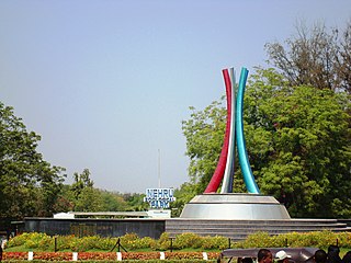
Nehru Zoological Park is a zoo located near Mir Alam Tank in Bahadurpura, Telangana, India. It is one of the most visited destinations in Hyderabad.
Meerpet–Jillelguda is a satellite city of Hyderabad and a municipal corporation in Rangareddy district of the Indian state of Telangana. The municipal corporation was formed after merging municipality of Meerpet and Jillelguda.

The Hyderabad Metro is a rapid transit system, serving the city of Hyderabad, Telangana, India. It is the third longest operational metro network in India after Delhi Metro and Namma Metro (Bengaluru), and the lines are arranged in a secant model. It is funded by a public–private partnership (PPP), with the state government holding a minority equity stake. Hyderabad Metro is the world's largest elevated Metro Rail system based on DBFOT basis. A special purpose vehicle company, L&T Metro Rail Hyderabad Ltd (L&TMRHL), was established by the construction company L&T to develop the Hyderabad metro rail project.

Moazzam Jahi Market is a historic market in Hyderabad, Telangana, India. Built in the twentieth century, it is located at the crossroads of Jam Bagh, Begum Bazaar, and Station Road.

Khairatabad is a neigbbourhood in Hyderabad, Telangana, India. It is a mandal in the Secunderabad Revenue division of Hyderabad District. This is a Zone in the Greater Hyderabad Municipal Corporation. There are five circles in this zone namely Mehdipatnam (12), Karwan (13), Goshamahal (14), Khairatabad (17) and Jubilee Hills (18). There are four wards under this Khairatabad circle, they are Khairtabad (91), Somajiguda (97), Ameerpet (98) and Sanathnagar (100).

Hyderabad is located in central Telangana and is spread over an area of 2,500 km2. The city lies in the Deccan Plateau and rises to an average height of 536 m above the sea level. The city lies at 17.366° N latitude and 78.476° E longitude.
Bagh Lingampally is a commercial and residential neighbourhood of Hyderabad, Telangana, India. It has become one of the many major centers of Hyderabad. It has been a home to one of Royalties of Hyderabad, Khan Bahadur Abdulkareem Lal Khan, Former Kotwal in the 7th Nizams Government. And this area used to be full of fruit gardens belonging to them, from where prefix ‘Bagh' is derived. The place had a small village called Lingampally which had a tank where queens would bathe. The locality has gained importance due to close proximity to RTC X Roads, Chikkadpally, Barkatpura, Himayathnagar, Nallakunta and Koti. This suburb is a mixture of the Old and New City cultures of Hyderabad. There is a vegetable market on Saturdays.

Lumbini Park, officially T. Anjaiah Lumbini Park, is a small public, urban park of 3 hectares adjacent to Hussain Sagar in Hyderabad, India. Since it is located in the centre of the city and is in close proximity to other tourist attractions, such as Birla Mandir and Necklace Road, it attracts many visitors throughout the year. Boating is one of the best part and people go to the Buddha idol placed in the middle of the tank band in the boats. Constructed in 1994, the park is named after the former Chief Minister of Andhra Pradesh T. Anjaiah. The park is maintained by the Buddha Purnima Project Authority that functions under the directives of the Government of Telangana. In 2007, it was one of the targets of the 25 August 2007 Hyderabad bombings that killed 44 people.

Hussain Sagar is a heart-shaped lake in Hyderabad, Telangana, built by Ibrahim Quli Qutb Shah in 1563. It is spread across an area of 5.7 square kilometres (2.2 sq mi) and is fed by the River Musi. A large monolithic statue of the Gautama Buddha, erected in 1992, stands on Gibraltar Rock in the middle of the lake. It also separates the city centre of Hyderabad from the neighbourhood of Secunderabad. The maximum depth of the lake is 32 feet (9.8 m).

Hussain Sagar Thermal Power Station was a historic thermal power plant that was located in Hyderabad, Telangana on the banks of Hussain Sagar. It was India's first thermal power station, opened in 1920 by the erstwhile seventh Nizam of Hyderabad.

The Old City of Hyderabad is a walled city of Hyderabad, Telangana, India, located on the banks of the Musi River built by Qutb Shahi sultan Muhammed Quli Qutb Shah in 1591 AD. There used to be a wall surrounding the Old City, most of which is destroyed. Mubariz Khan, the Mughal governor of Deccan Subah, had fortified the city in 1712 and was completed by Nizam of Hyderabad.

Telangana State Road Transport Corporation is a state-owned corporation that runs bus transport services to and from the Indian state of Telangana. It was formed in 2014 by splitting the Andhra Pradesh State Road Transport Corporation. Many other Indian metro towns in Andhra Pradesh, Karnataka, Maharashtra, Goa, Odisha and Chhattisgarh are also linked with the services of TSRTC. It serves about 6 million passengers every day, having three zones and services operating through 99 depots.
Jalal Baba Nagar is a major suburb in Hyderabad, Telangana, India. It is under the jurisdiction of Greater Hyderabad within the Revenue Limits of Attapur and is close to Attapur and Kishan Bagh. This area was a hilly forest and was least inhabited in the past and the famous lake Mir Alam Tank located here and Road No. 9 bypass of National Highway 7 passes through this area.

