The Mississippi River is the second-longest river and chief river of the second-largest drainage system in North America, second only to the Hudson Bay drainage system. From its traditional source of Lake Itasca in northern Minnesota, it flows generally south for 2,340 miles (3,770 km) to the Mississippi River Delta in the Gulf of Mexico. With its many tributaries, the Mississippi's watershed drains all or parts of 32 U.S. states and two Canadian provinces between the Rocky and Appalachian mountains. The main stem is entirely within the United States; the total drainage basin is 1,151,000 sq mi (2,980,000 km2), of which only about one percent is in Canada. The Mississippi ranks as the thirteenth-largest river by discharge in the world. The river either borders or passes through the states of Minnesota, Wisconsin, Iowa, Illinois, Missouri, Kentucky, Tennessee, Arkansas, Mississippi, and Louisiana.
The Driftless Area, a topographical and cultural region in the American Midwest, comprises southwestern Wisconsin, southeastern Minnesota, northeastern Iowa, and the extreme northwestern corner of Illinois.

Savanna Portage State Park is a state park of Minnesota, USA, established in 1961 to preserve the historic Savanna Portage, a difficult 6-mile (9.7 km) trail connecting the watersheds of the Mississippi River and Lake Superior. The portage trail crosses a drainage divide separating the West Savanna River, which drains to the Mississippi River and the Gulf of Mexico, from the East Savanna River, which flows in an opposite direction to the Saint Louis River, Lake Superior and the Great Lakes, and the Saint Lawrence River to the Atlantic Ocean.

Dixon Springs State Park is an Illinois state park in Pope County, Illinois, United States, and is one of several state parks in the Illinois Shawnee Hills. The park is on a giant block of rock which was dropped 200 feet (61 m) along a fault that extends northwesterly across Pope County. The 801-acre (324 ha) park is about 10 miles (16 km) west of Golconda on Illinois Route 146, near its junction with Illinois Route 145. The first land acquisition was in 1946.
Beall Woods State Park is an Illinois state park on 635 acres (257 ha) bordering the Wabash River and Keensburg in Wabash County, Illinois in the United States. 329 acres (133 ha) of the state park is an old-growth forest designated as a Natural Area by the state of Illinois. The trees within the forest consist overwhelmingly of hardwoods of the former Eastern Woodlands ecosystem. Portions of Beall Woods State Park have been designated a National Natural Landmark as the Forest of the Wabash. The state park was created in 1966. The nearest towns with any sizable commercial infrastructure, including hotels and grocery stores, are Grayville and Mount Carmel. The park does host a small primitive campground and maintains a visitor center which opened in April 2001. The park maintains 6+1⁄4 miles (10.1 km) of hiking trails, primarily through the Forest of the Wabash portion of the park.
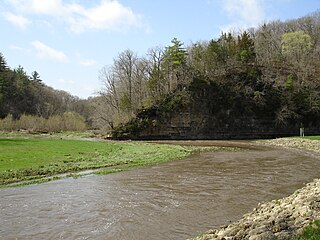
The Apple River is a tributary of the Mississippi River, about 55 miles (89 km) long, in southwestern Wisconsin and northwestern Illinois in the United States. It rises in Lafayette County, Wisconsin, and flows for most of its length in Illinois, through Jo Daviess and Carroll Counties. Along its course it passes through Apple River Canyon State Park and the town of Hanover. It flows into the Mississippi River about 7 mi (11 km) northwest of Savanna.
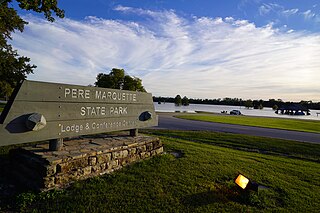
Pere Marquette State Park is an 8,050-acre (3,260 ha) protected area in southwestern Jersey County, Illinois, United States. It is located near the city of Grafton, Illinois, at the confluence of the Mississippi River and the Illinois River. The park is located on Illinois Route 100, which at this location is also part of both the Great River Road and the Meeting of the Great Rivers Scenic Byway. The park is operated and maintained by the Illinois Department of Natural Resources, and is Illinois' largest state park in area. The park is also part of the Confluence Greenway and is at the northwestern end of the 21.5-mile (34.6 km) Sam Vadalabene Bike Trail.
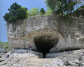
Cave-In-Rock State Park is an Illinois state park, on 204 acres (0.83 km2), in the town of Cave-in-Rock, Hardin County, Illinois in the United States. The state park contains the historic Cave-In-Rock, a landmark of the Ohio River. It is maintained by the Illinois Department of Natural Resources (IDNR).
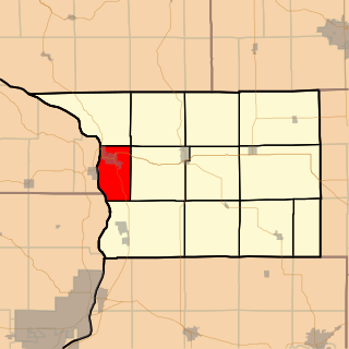
Savanna Township is one of twelve townships in Carroll County, Illinois, USA. As of the 2010 census, its population was 3,729 and it contained 2,004 housing units.

Washington Township is one of twelve townships in Carroll County, Illinois, USA. As of the 2010 census, its population was 356 and it contained 198 housing units.
Giant City State Park is an Illinois state park on 4,000 acres (1,619 ha) in Jackson and Union Counties, Illinois, United States. Illinois acquired more than 1,100 acres (450 ha) in 1927, and dedicated the park as Giant City State Park. A lodge and visitor center welcome state park guests.

Horseshoe Lake State Park is an Illinois state park in Madison County, Illinois, United States. It is approximately 2,960 acres (1,198 ha) and surrounds a large horseshoe-shaped lake called Horseshoe Lake. Horseshoe Lake is the second largest natural lake in Illinois taking up approximately 2,400 acres (971 ha) of the 2,960-acre (1,198 ha) park. The park has connections to Madison County Transit's Schoolhouse Trail, which connects to over 85 miles (137 km) of bike trail in Madison County, and even a trail which goes all of the way to downtown St. Louis after crossing the Mississippi River on the Chain of Rocks Bridge. The park is located in southeastern Granite City, Illinois, just a 10-mile (16 km) drive northeast of downtown St. Louis.
Prophetstown State Park is an Illinois state park on 53 acres (21 ha) in Whiteside County, Illinois, United States. Situated on south bank of the Rock River adjoining modern Prophetstown, Illinois, it was the site of a native American village founded by Ho-Chunk chief Wabokieshiek along the Sauk Trail and populated in the early 19th century by Native Americans of various tribes who did not wish to evacuate across the Mississippi River as whites emigrated to the area. It became a strategic target during the Black Hawk War. Illinois militia general Samuel Whiteside ordered the recently abandoned village burned on May 10, 1832.
Green River State Wildlife Area is an Illinois state park on 2,565 acres (1,038 ha) in Lee County, Illinois, United States.
The Iroquois County State Wildlife Area is an Illinois state park that occupies 2,480 acres (1,004 ha) in northeastern Iroquois County, near the border with Indiana. The nearest municipality is Beaverville, Illinois, and the nearest exit on a limited-access highway is Exit 302 on Interstate 57.
Kaskaskia River State Fish and Wildlife Area is an Illinois state park on 20,000 acres (8,094 ha) in St. Clair, Monroe, and Randolph Counties, Illinois, United States. A focus of this conservation area is Baldwin Lake, a perched cooling pond managed by the Illinois Department of Natural Resources for fishing.
Shelbyville State Fish and Wildlife Area is an Illinois state park on 6,200 acres (2,500 ha) in Moultrie County, Illinois, United States. It covers part of the watershed of Lake Shelbyville.

Cache River State Natural Area is an Illinois state park centered on the Cache River (Illinois) of 14,314 acres (5,793 ha) in Johnson County, Illinois, United States.

Fults Hill Prairie State Natural Area, also known as the Fults Hill Prairie Nature Preserve, is an Illinois Nature Preserve on 997 acres (403 ha) in Monroe County, Illinois, United States. A key feature of the preserve is a 532-acre (215 ha) hill prairie located on the east bluff of the Mississippi River overlooking the American Bottom near Fults, Illinois. The Fults Hill Prairie has been listed as a National Natural Landmark.