A supplemental route is a state secondary road in the U.S. state of Missouri, designated with letters. Supplemental routes were various roads within the state which the Missouri Department of Transportation was given in 1952 to maintain in addition to the regular routes, though lettered routes had been in use from at least 1932.[1][2] The four types of roads designated as Routes are:
Short routes connecting state highways from other states to routes in Missouri
Supplemental routes make up 19,064 miles (30,681km) (59%) of the state highway system.
History
Prior to 1907, all road improvement activities in Missouri were undertaken by the individual counties, with little expertise or coordination between them. Amid growing automobile presence and insufficient road networks in Missouri in the ensuing years, the state legislature created a state highway department and the state highway commission as well as enacted various laws aimed at improving transportation in the state.[1] In 1920, recognizing that economic prosperity and growth are highly related to good transportation, the legislature passed a $60 million bond issue for road work.[3] This effort, along with the Centennial Road Law passed by the legislature in 1921, shifted highway building efforts in Missouri from the local level to the state level. As a result, the state highway commission undertook an aggressive road building campaign throughout the 1920s and 1930s aimed to get Missouri "out of the mud".[1]
In 1952, the state highway department embarked on its Missouri 10-Year Highway Modernization and Expansion Program. Through this effort, the state assumed maintenance responsibility of over an additional 12,000 miles (19,000km) of secondary and farm-to-market roads previously managed by the counties.[1] The goal of the secondary highway system was to place state-maintained roads within 2 miles (3.2km) of more than 95% of all rural farm houses, schools, churches, cemeteries and stores.[4] Most of Missouri's lettered supplemental highways are the result of this program.
Highway designations
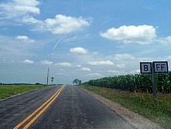
Top: Missouri Supplemental Routes B and FF concur in Nodaway County. Bottom: Spur Route N detaches from its parent route in Cedar County.
The more major supplemental routes of the system are assigned single-letter designations (such as "K"). Minor branch routes and farm-to-market roads, which often end at county roads or are former alignments of the other highways, are typically assigned two-letter designations consisting of two of the same letter (e.g. "KK"). Additionally, combinations of letters may be used, but always with A as the first letter (such as "AD"); the only exceptions to this are Route BA in western St. Louis County. Combinations beginning with the letter R are also used for routes that connect with state parks or other recreational facilities, which is the only use of R on the system; Route AR, south of Bakersfield, is the only non-recreational route with an R in it.
The vast majority of the highways in the system are designated with 19 letters of the alphabet. The letters "G", "I", "L", "Q", and "S" are not used because of the potential confusion with other letters and numbers. The only use of X is on Route AX in Macon County.
Supplemental routes rarely run for more than a few miles, although they may cross county lines. A route's designation changes at a U.S. Route or Interstate highway; for example, in Greene County, southbound Route J crosses U.S. Route 60 and becomes Route NN, and Route M in Cole County becomes Route J after passing U.S. Route 50. However, when Route MM in Greene County crosses Route 360, it remains Route MM, only changing to Route B when crossing Interstate 44. Route J in Boone County is one of the few exceptions to this, as it continues past U.S. 40 for three miles before becoming Route O upon passing I-70. Designations are also reused, but not near one another. For example, Route D exists in the counties of Cole, Greene, Newton, St. Louis, and several others. Rarely is a designation reused in a county; exceptions include two highways designated Route Z in Randolph County and two highways designated Route K in Carter County.
In some cases, supplemental routes will share a concurrency with a state route or another supplemental route. For example, Route J in Howard County overlaps with Route 87 for about 0.25 miles (0.40km) near Boonesboro, Route D in Greene County overlaps with Route 125 for a few miles, Route N and Route O in Franklin County overlap for 2.02 miles (3.25km) between Catawissa and Robertsville, and Route CC in Moniteau County overlaps with Route C for a few miles.
It is erroneously believed that due to these roads being designated by letters rather than numbers and their existing in more than one county that these roads are county roads, not state highways, with some businesses and residences located on these roads saying their address is "County Road A" for example. This may have also arisen from the signage used prior to the early 1960s, where the letter was painted black against a white background, with the words "STATE ROAD" above the letter and the county name (in all capital letters) below the letter, or from the use of letters representing county trunk routes in Wisconsin.
In the United States, a farm-to-market road or ranch-to-market road is a state highway or county road that connects rural or agricultural areas to market towns. These are better-quality roads, usually a highway, that farmers and ranchers use to transport products to market towns or distribution centers. Historically used throughout the country, today the term is primarily associated with a large state-maintained highway system in Texas.
Texas state highways are a network of highways owned and maintained by the U.S. state of Texas. The Texas Department of Transportation (TxDOT) is the state agency responsible for the day-to-day operations and maintenance of the system. Texas has the largest state highway system, followed closely by North Carolina's state highway system. In addition to the nationally numbered Interstate Highways and U.S. Highways, the highway system consists of a main network of state highways, loops, spurs, and beltways that provide local access to the other highways. The system also includes a large network of farm to market roads that connect rural areas of the state with urban areas and the rest of the state highway system. The state also owns and maintains some park and recreational roads located near and within state and national parks, as well as recreational areas. All state highways, regardless of classification, are paved roads. The Old San Antonio Road, also known as the El Camino Real, is the oldest highway in the United States, first being blazed in 1691. The length of the highways varies from US 83's 893.4 miles (1,437.8 km) inside the state borders to Spur 200 at just 0.05 miles long.
Route 102 is a highway in southeastern Missouri. The route starts at Route 105 near East Prairie. It travels southeastwards through farmland to Big Oak Tree State Park. The road then turns east past the entrance to the park, and ends at its eastern terminus at Route 77 in Dorena. The route was designated in 1940, as a road from the state park to a supplemental route. Route 102 replaced a large section of the supplemental route in 1961, and then was extended eastwards to a new terminus at Route 77 in 1994.
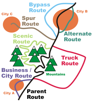
In road transportation in the United States, a special route is a road in a numbered highway system that diverts a specific segment of related traffic away from another road. They are featured in many highway systems; most are found in the Interstate Highway System, U.S. highway system, and several state highway systems. Each type of special route possesses generally defined characteristics and has a defined relationship with its parent route. Typically, special routes share a route number with a dominant route, often referred as the "parent" or "mainline", and are given either a descriptor which may be used either before or after the route name, such as Alternate or Business, or a letter suffix that is attached to the route number. For example, an alternate route of U.S. Route 1 may be called "Alternate U.S. Route 1", "U.S. Route 1 Alternate", or "U.S. Route 1A". Occasionally, a special route will have both a descriptor and a suffix, such as U.S. Route 1A Business.
Highway 1 is a north–south state highway in east Arkansas. The route of 159.88 miles (257.30 km) runs from US Route 278 (US 278) in McGehee north to Supplemental Route BB at the Missouri state line. One of the original 1926 state highways, Highway 1 has remained very close to its original routing. The highway contains an overlap of approximately 50 miles (80 km) with U.S. Route 49.
Highway 94 is an east–west state highway in Benton County, Arkansas. The route of 22.07 miles (35.52 km) runs from Horseshoe Bend Park near Beaver Lake west across US Route 71 Business (US 71B) and US 62 to Missouri Supplemental Route E at the Missouri state line. The route is maintained by the Arkansas State Highway and Transportation Department (AHTD).
Numerous special routes of U.S. Route 67, all business routes, exist. One other route, formerly an alternate route in western Illinois, has since been downgraded to state Route 267.
The Arkansas Highway System is made up of all the highways designated as Interstates, U.S. Highways and State Highways in the US state of Arkansas. The system is maintained by the Arkansas Department of Transportation (ArDOT), known as the Arkansas State Highway Department (AHD) until 1977 and the Arkansas State Highway and Transportation Department (AHTD) from 1977 to 2017. The system contains 16,442.90 miles (26,462.28 km) of Interstates, U.S. Routes, state highways, and special routes. The shortest members are unsigned state highways Arkansas Highway 806 and Arkansas Highway 885, both 0.09 miles (0.14 km) in length. The longest route is U.S. Route 67, which runs 296.95 miles (477.89 km) from Texarkana to Missouri.
Farm to Market Road 471 is an FM highway in the San Antonio area of Texas. The highway is known as Culebra Road within Bexar County.
This page is based on this Wikipedia article Text is available under the CC BY-SA 4.0 license; additional terms may apply. Images, videos and audio are available under their respective licenses.