
Madison County is located in the north central portion of the U.S. state of Alabama. As of the 2020 Census, the population was 388,153, making it the third-most populous county in Alabama. Its county seat is Huntsville. Since the mid-20th century it has become an area of defense and space research and industry.

Huntsville is a city in Madison County and Limestone County, Alabama, US, with a small portion extending into Morgan County. It is the county seat of Madison County. Located in the Appalachian region of northern Alabama, Huntsville is the most populous city proper in the state.

The Catskill Mountains, also known as the Catskills, are a physiographic province of the larger Appalachian Mountains, located in southeastern New York. As a cultural and geographic region, the Catskills are generally defined as those areas close to or within the borders of the Catskill Park, a 700,000-acre (2,800 km2) forest preserve protected from many forms of development under New York state law.
Monte Sano State Park is a public recreation area and mountaintop retreat encompassing 2,140 acres (870 ha) on the eastern portion of the top and slopes of Monte Sano Mountain on the east side of Huntsville, Alabama. The state park has 1930s-era, Civilian Conservation Corps–built rustic cottages, hiking trails and picnic areas with scenic overlooks, and modern campsites. It is managed by the Alabama Department of Conservation and Natural Resources.
Big Spring International Park is located in downtown Huntsville, Alabama. The park is built around its namesake "Big Spring", the original water source that the city of Huntsville was built around. The Huntsville Museum of Art and Von Braun Center are located in the park. The park is also notable as the venue for the Panoply Arts Festival, held the last full weekend in April, Big Spring Jam, an annual music festival held on the fourth weekend in September from 1993 to 2011, and The Battle of the Buffalo, a buffalo wings competition held by the University of Alabama in Huntsville Alpha Tau Omega fraternity to support cancer research.

Blue Knob State Park is a 6,128-acre (2,480 ha) Pennsylvania state park in Kimmel, Lincoln, and Pavia townships in Bedford County, Pennsylvania, in the United States. The average annual snowfall at the park is about 12 feet (370 cm). The park is named for Blue Knob, the second highest mountain in Pennsylvania at 3,146 feet (959 m). It is the location of Blue Knob All Seasons Resort, the ski slope in Pennsylvania with the highest elevation. Blue Knob State Park is just off Interstate 99 on Pennsylvania Route 869 west of Pavia.
Hampton Cove is a master-planned housing subdivision located in Big Cove area of Huntsville, Alabama. Situated in the foothills and valleys of North Alabama's Cumberland Plateau, the 2,800-acre (11 km2) Housing lies in the coves between Monte Sano Mountain and Green Mountain to the west, and Keel Mountain to the east.

Monte Ne was a health resort and planned community established and operated by William Hope Harvey from 1901 into the 1920s. It was located in a valley just east of the town of Rogers, Arkansas, though today its location is mostly under the waters of Beaver Lake. The resort consisted of several hotels, a lake, an indoor swimming pool, a golf course, tennis courts, bowling alleys, its own post office and bank, as well as a dedicated train line and an imported Italian gondola to conduct guests to the resort. In 1931 Monte Ne was the site of the only presidential convention ever held in the state.

The Memphis and Charleston Railroad, completed in 1857, was the first railroad in the United States to link the Atlantic Ocean with the Mississippi River. Chartered in 1846, the 311 miles (501 km) 5 ft gauge railroad ran from Memphis, Tennessee to Stevenson, Alabama through the towns of Corinth, Mississippi and Huntsville, Alabama. The portion between Memphis and LaGrange, Tennessee was originally to be part of the LaGrange and Memphis Railroad, chartered in 1838. From Stevenson, the road was connected to Chattanooga, Tennessee via the Nashville and Chattanooga Railroad. In Alabama, the railroad followed the route of the Tuscumbia, Courtland and Decatur Railroad between Tuscumbia and Decatur, the first railroad to be built west of the Appalachian Mountains.
Keel Mountain is a mesa in Madison and Jackson Counties in Alabama. It is associated with the Cumberland Plateau, which it is separated from by the valley of the Paint Rock River. It is named for early pioneers Jesse and Priscilla (Whitaker) Keel, who settled there from North Carolina prior to 1810.
Big Cove is an unincorporated community in Madison County, Alabama, United States. It is located roughly seven miles southeast of downtown Huntsville. Big Cove also encompasses the growing community of Hampton Cove. The city of Huntsville has annexed most of the community.
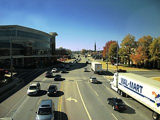
Governors Drive is a major east–west thoroughfare in Huntsville, Alabama. It follows U.S. Route 431 (US-431) in east Huntsville and State Route 53 (SR-53) in west Huntsville. Governors Drive is one of the main entrance points to the city from the east, carrying on average approximately 48,000 vehicles a day across Monte Sano Mountain.

An extensive collection of parks and greenways exists in Huntsville, Alabama for the public's recreational use.

The Monte Sano Railroad Workers' House is a historic boarding house in Huntsville, Alabama, United States. Built in 1888, it is the only remaining building relating to the Monte Sano Hotel and Railroad. The North Alabama Improvement Company built the three-story, Queen Anne hotel on Monte Sano Mountain in 1887. The following year, construction began on a rail line connecting the hotel with the Memphis and Charleston Depot downtown. The house was constructed to house workers building and later operating the railroad.
Jones Valley is an urbanized valley and region of Huntsville, Alabama. The community is bordered by Monte Sano Mountain and Green Mountain to the east and Waltons Mountain to the west.
Monte Sano Nature Preserve is, at 1,107 acres (448 ha), one of the largest urban nature preserves in the US and is located on Monte Sano Mountain in Huntsville, Alabama. The Land Trust of North Alabama manages the nature preserve and Land Trust volunteers have created 23+ miles of public trails. Residents and visitors alike enjoy the multi-use trails for hiking, biking, running, bird watching, environmental education, and general recreation. The trail system was honored in 2011 by the Department of the Interior as National Recreation Trails making them the first NRT trails in Madison County.

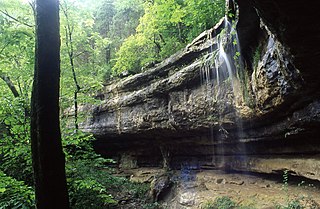
Blevins Gap Nature Preserve is a nature preserve in southern Huntsville, Alabama. It measures 994 acres (402 ha) in total and contains over 12 miles of trails within its borders. Cecil Ashburn Drive splits the preserve into two parts. The northern section measures 267 acres (108 ha) with 4.5 miles of trails, a rocky incline, and waterfalls. The southern portion measures the remaining 727 acres (294 ha) and contains 8 miles of woodland trails.
Rainbow Mountain is a mountain in Madison county, Alabama. The mountain's name is derived from the name of Elisha Rainboll, who settled on the mountain around the year 1810.


