
Essex County is a county located in the northeastern part of the U.S. state of Vermont. As of the 2020 census, the population was 5,920, making it the least-populous county in both Vermont and New England. Its shire town is the municipality of Guildhall. The county was created in 1792 and organized in 1800. Bordered by the Connecticut River next to New Hampshire, Essex County is south of the Canadian province of Quebec. It is the county with the lowest household-income in Vermont.

Whitewater Township is a civil township of Grand Traverse County in the U.S. state of Michigan. The population was 2,688 at the 2020 census, an increase from 2,597 at the 2010 census. Whitewater Township includes shores on Elk Lake and Lake Skegemog, two large lakes in the Chain of Lakes. A portion of the township is within the Grand Traverse Indian Reservation.

The Androscoggin River is a river in the U.S. states of Maine and New Hampshire, in northern New England. It is 178 miles (286 km) long and joins the Kennebec River at Merrymeeting Bay in Maine before its water empties into the Gulf of Maine on the Atlantic Ocean. Its drainage basin is 3,530 square miles (9,100 km2) in area. The name "Androscoggin" comes from the Eastern Abenaki term Ammoscocongon, which referred to the entire portion of the river north of the Great Falls in Lewiston, Maine. The Anglicization of the Abenaki term is likely an analogical contamination with the colonial governor Edmund Andros.

Deerfield River is a river that runs for 76 miles (122 km) from southern Vermont through northwestern Massachusetts to the Connecticut River. The Deerfield River was historically influential in the settlement of western Franklin County, Massachusetts, and its namesake town. It is the Connecticut River's second-longest tributary in Massachusetts, 2.1 miles (3.4 km) shorter than Metropolitan Springfield's Westfield River.
The Jail Branch River is a river in central Vermont. It is a tributary of the Stevens Branch of the Winooski River and part of the Lake Champlain watershed.

The Vermont House of Representatives is the lower house of the Vermont General Assembly, the state legislature of the U.S. state of Vermont. The House comprises 150 members, with each member representing around 4,100 citizens. Representatives are elected to a two-year term without term limits.

Lake Memphremagog is a fresh water glacial lake located between Newport, Vermont, United States and Magog, Quebec, Canada. The lake spans both Quebec and Vermont, but is mostly in Quebec. Most of the watershed that feeds the lake is located in Vermont, and is a source for accumulated phosphorus, sediments, and other pollutants. Cleanup efforts since the late 1980s have improved the water quality. The lake furnishes potable water for 200,000 people.

Black Moshannon Creek is a 22.9-mile-long (36.9 km) tributary of Moshannon Creek in Centre County, Pennsylvania in the United States.

The West River is a tributary of the Connecticut River, about 53.8 miles (86.6 km) long, in southern Vermont in the United States. According to the Geographic Names Information System, it has also been known historically as "Wantastiquet" and as "Waters of the Lonely Way". Its watershed covers 423 square miles (1,100 km2); land use is about 90% forested and 3% agricultural, and the upper river supports wild native brook and wild brown trout, while Atlantic salmon occur in most of the river.
The Rock River is a 12.9-mile-long (20.8 km) tributary of the West River in southern Vermont in the United States. Via the West River, it is part of the watershed of the Connecticut River.

The Waits River is a 24.5-mile-long (39.4 km) river in eastern Vermont in the United States. It is a tributary of the Connecticut River, which flows to Long Island Sound. According to the Geographic Names Information System, it has also been known historically as "Wait's River" and as "Ma-houn-quam-mas-see." The Waits River Formation is a rock unit named after the river since it underlies most of the river.
The Northern Forest Canoe Trail (NFCT) is a 740-mile (1,190 km) marked canoeing trail in the northeastern United States and Canada, extending from Old Forge in the Adirondacks of New York to Fort Kent, Maine. Along the way, the trail also passes through the states and provinces of Vermont, Quebec, and New Hampshire. The trail was opened on June 3, 2006.

The Black River is a 40.8-mile-long (65.7 km) river in the U.S. state of Vermont, and a tributary of the Connecticut River. The river's watershed consists of approximately 202 square miles (520 km2) in southeastern Vermont, almost all of which lies in Windsor County.

The Lamoille River is a river which runs through northern Vermont and drains into Lake Champlain. It is about 85 miles (137 km) in length, and has a drainage area of around 706 square miles (1,830 km2). The river generally flows southwest, and then northwest, from the water divide of the Green Mountains. It is the namesake of Lamoille County, Vermont, through which it flows. The river was the basis of the name of the now-defunct Lamoille Valley Railroad Company, successor to the St. Johnsbury and Lamoille County Railroad.
The Wells River is a tributary of the Connecticut River, approximately 15 miles (24 km) long, in the U.S. state of Vermont.

The Passumpsic River is a 22.7-mile-long (36.5 km) tributary of the Connecticut River, in Vermont. Though primarily a Caledonia County river, it is the only river to flow through all three counties of the Northeast Kingdom.

The Mad River is a tributary to the Winooski River in Vermont. It has its headwaters in Granville Gulf, then flows north through the towns of Warren, Waitsfield, and Moretown before entering the Winooski River just downstream from Middlesex. Other towns within the Mad River watershed are the entire Town of Fayston and a portion of the Town of Duxbury. Relative to other rivers in the state, the Mad River is fairly rocky and clear, making it a popular for swimming. In the summer of 2008, didymo, or Rock Snot, was found in the upper portions of the river.

The Browns River is an approximately 20-mile (32 km) waterway in northern Vermont. It is a tributary of the Lamoille River.
East Barre Dam is a dam in East Barre, Washington County, Vermont.
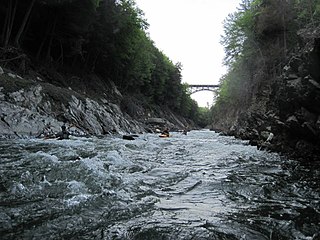
The Quechee Gorge is located in Quechee, Vermont along U.S. Route 4. The gorge is 165 feet deep and is the deepest gorge in Vermont. It serves as a popular tourist attraction in Quechee State Park and can be viewed from the U.S. Route 4 bridge and from trails on both sides of the gorge. Many people from around New England flock to the gorge for the views. The Ottauquechee River flows through the bottom of the gorge and is a popular whitewater kayak run.
