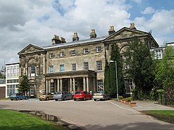
Great Barr Hall is an 18th-century mansion situated at Pheasey, Walsall, on the border with Great Barr, Birmingham, West Midlands, England. It has associations with the Lunar Society and is a Grade II listed building. It is, however, in a very poor state of repair and is on the Buildings at Risk Register.
Bournville is a model village on the southwest side of Birmingham, England, founded by the Quaker Cadbury family for employees at its Cadbury's factory, and designed to be a "garden" village where the sale of alcohol was forbidden. Cadbury's is well known for chocolate products – including a dark chocolate bar branded Bournville. Historically in northern Worcestershire, it is also a ward within the council constituency of Selly Oak and home to the Bournville Centre for Visual Arts. Bournville is known as one of the most desirable areas to live in the UK; research by the Joseph Rowntree Foundation in 2003 found that it was "one of the nicest places to live in Britain".

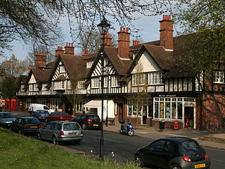
Acocks Green is an area and ward of southeast Birmingham, England. It is named after the Acock family, who built a large house there in 1370. Acocks Green is one of four wards making up Yardley formal district. It is occasionally spelled "Acock's Green". It has frequently been noted on lists of unusual place names.

Cookridge is a suburb of north-west Leeds, West Yorkshire, England, north of the Leeds Outer Ring Road. In 1715 Ralph Thoresby described it as a village four miles from Leeds and three from Otley, dating from 1540.

Although Birmingham in England has existed as a settlement for over a thousand years, today's city is overwhelmingly a product of the 18th, 19th, and 20th centuries, with little surviving from its early history. As it has expanded, it has acquired a variety of architectural styles. Buildings of most modern architectural styles in the United Kingdom are located in Birmingham. In recent years, Birmingham was one of the first cities to exhibit the blobitecture style with the construction of the Selfridges store at the Bullring Shopping Centre.

William Alexander Harvey was an English architect. He is most notable for his design of Bournville, the model 'garden suburb' built by Cadburys to house their chocolate-making workforce to the south of Birmingham.

Longford Hall is a large country house in Longford, a village in Shropshire, England near the town of Newport.

City Hospital is a major hospital located in Birmingham, England, operated by the Sandwell and West Birmingham Hospitals NHS Trust. It provides an extensive range of general and specialist hospital services. It is located in the Winson Green area of the west of the city.

The Public Library and Baths on Moseley Road, Balsall Heath, form one of many pairings of baths and libraries in Birmingham, England.

Yarlington is a village and civil parish, near the source of the River Cam, in the English county of Somerset.

Sparkford is a village and civil parish in the South Somerset district of Somerset, England. The parish includes the village of Weston Bampfylde.
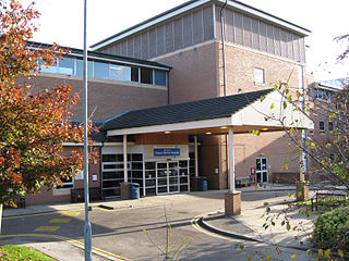
Chapel Allerton Hospital is located in the area of Chapel Allerton, Leeds, West Yorkshire, England and is operated by the Leeds Teaching Hospitals NHS Trust. The main entrance is on Chapeltown Road, with vehicle exits onto Harehills Lane and Newton Road.

Roughley is an electoral ward within the Royal Town of Sutton Coldfield, and is the most northerly part of the administrative area covered by the Royal Sutton Coldfield Town Council and the City of Birmingham. Over half of Roughley Ward is attractive Green Belt countryside, including arable and dairy farms, historic field boundaries survive with mature hedgerows and woodlands. Several public footpaths provide access to the countryside and the one linking Hillwood Road and Dale Farm provides distant views of Lichfield Cathedral and on a clear day the Pennine Hills.

The Royal Lancaster Infirmary (RLI) is a hospital in the city of Lancaster, England. It lies to the south of the city centre, between the A6 road and the Lancaster Canal. It is managed by the University Hospitals of Morecambe Bay NHS Foundation Trust.

Northfield Manor House is a Manor House, on Bristol Road South, Northfield, Birmingham, England. It was formerly known as Manor Farm, and under that name was home to George and Elizabeth Cadbury.
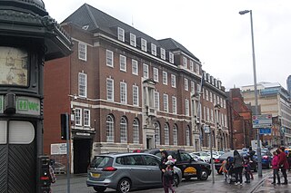
Steelhouse Lane police station is a former police station in central Birmingham, England. It was built for the Birmingham City Police and opened in 1933 as their Central Police Station, replacing a Victorian station on the same site. It was used by their successor, the West Midlands Police, until 2017 where they transferred to Lloyd House, also the force's HQ. The carvings over the entrances, including the coat of arms of Birmingham, are by the local sculptor William Bloye.

The Friends Institute Buildings are a former Religious Society of Friends (Quaker) meeting house, community facilities, and associated structures, at 220, Moseley Road, Balsall Heath, Birmingham, England. The various parts are now used as an Art therapy centre, and the Moseley Road Community Centre. In September 2014, the buildings were granted Grade II* designation.

Moseley Park and Pool is an 11-acre (4.5 ha) private park in Moseley, Birmingham, maintained by the Moseley Park and Pool Trust. It is located to the west of the district centre and the A435 Alcester Road; it sits in the Birmingham City Council electoral ward of Moseley and is situated very close to the border with Balsall Heath West.