
According to The World Factbook, the main natural phenomena posing a threat in Italy at a regional level are landslides, mudflows, avalanches, earthquakes, volcanic eruptions, floods and, in Venice, subsidence. [1]
According to The World Factbook, the main natural phenomena posing a threat in Italy at a regional level are landslides, mudflows, avalanches, earthquakes, volcanic eruptions, floods and, in Venice, subsidence. [1]
As released by the Italian Institute for Environmental Protection and Research (ISPRA), 2.2% of Italian population lives in areas at high or very high risk from landslides, and 3.8% of buildings and 5.8% of cultural heritage sites are located in those places. [2] In the period between 1970 and 2019, landslides caused 1085 deaths, 10 missing people, and 1454 non-fatal injuries. The regions with the highest mortality rate in that period were Aosta Valley and Trentino-Alto Adige/Südtirol. [3]

Being placed in the convergence between the Eurasian Plate and the African Plate, Italy (with the relative exception of Sardinia) suffers from seismicity, which is particularly high along the Apennine range, in Calabria, in Sicily and in some places of Northern Italy, such as Friuli, part of Veneto, and western Liguria. According to the Italian Civil Protection, the Italian seismic hazard is medium-high, while the vulnerability is very high also due to the fragility of the Italian building stock and the exposition is extremely high, as a consequence of the population density and the cultural heritage. [4]
As released by the Italian Institute of Environmental Protection and Research (IIEPR), 10.4% of Italian population lives in areas at high or very high risk from floods, and 9.3% of buildings and 15.3% of cultural heritage sites are located in those places. [2] In the period between 1970 and 2019, floods caused 585 deaths, 50 missing people, and 481 non-fatal injuries. The regions with the highest mortality rate in that period were Aosta Valley and Liguria. [3]
The Italian authorities have classified the Italian volcanoes on the basis of the time of the last eruption; besides submarine volcanoes and those considered extinct, in Italy there are dormant (Alban Hills, Phlegraean Fields, Ischia, Vesuvius, Lipari, Vulcano, Panarea, Pantelleria) and active volcanoes (Mount Etna and Stromboli) [5]

A natural disaster is the highly harmful impact on a society or community following a natural hazard event. Some examples of natural hazard events include: flooding, drought, earthquake, tropical cyclone, lightning, tsunami, volcanic activity, wildfire. A natural disaster can cause loss of life or damage property, and typically leaves economic damage in its wake. The severity of the damage depends on the affected population's resilience and on the infrastructure available. Scholars have been saying that the term natural disaster is unsuitable and should be abandoned. Instead, the simpler term disaster could be used, while also specifying the category of hazard. A disaster is a result of a natural or human-made hazard impacting a vulnerable community. It is the combination of the hazard along with exposure of a vulnerable society that results in a disaster.

A stratovolcano, also known as a composite volcano, is a conical volcano built up by many layers (strata) of hardened lava and tephra. Unlike shield volcanoes, stratovolcanoes are characterized by a steep profile with a summit crater and periodic intervals of explosive eruptions and effusive eruptions, although some have collapsed summit craters called calderas. The lava flowing from stratovolcanoes typically cools and hardens before spreading far, due to high viscosity. The magma forming this lava is often felsic, having high to intermediate levels of silica, with lesser amounts of less viscous mafic magma. Extensive felsic lava flows are uncommon, but have travelled as far as 15 km (9 mi).

Nevado del Ruiz, also known as La Mesa de Herveo is a volcano on the border of the departments of Caldas and Tolima in Colombia, about 129 km (80 mi) west of the capital city Bogotá. It is a stratovolcano composed of many layers of lava alternating with hardened volcanic ash and other pyroclastic rocks. Volcanic activity at Nevado del Ruiz began about two million years ago, since the Early Pleistocene or Late Pliocene, with three major eruptive periods. The current volcanic cone formed during the present eruptive period, which began 150,000 years ago.
A volcano observatory is an institution that conducts research and monitoring of a volcano.

The volcanism of Italy is due chiefly to the presence, a short distance to the south, of the boundary between the Eurasian Plate and the African Plate. Italy is a volcanically active country, containing the only active volcanoes in mainland Europe. The lava erupted by Italy's volcanoes is thought to result from the subduction and melting of one plate below another.

The Garibaldi Volcanic Belt is a northwest–southeast trending volcanic chain in the Pacific Ranges of the Coast Mountains that extends from Watts Point in the south to the Ha-Iltzuk Icefield in the north. This chain of volcanoes is located in southwestern British Columbia, Canada. It forms the northernmost segment of the Cascade Volcanic Arc, which includes Mount St. Helens and Mount Baker. Most volcanoes of the Garibaldi chain are dormant stratovolcanoes and subglacial volcanoes that have been eroded by glacial ice. Less common volcanic landforms include cinder cones, volcanic plugs, lava domes and calderas. These diverse formations were created by different styles of volcanic activity, including Peléan and Plinian eruptions.

Augustine Volcano is a stratovolcano in Alaska consisting of a central complex of summit lava domes and flows surrounded by an apron of pyroclastic, lahar, avalanche, and ash deposits. The volcano is frequently active, with major eruptions recorded in 1883, 1935, 1963–64, 1976, 1986, and 2006. Minor eruptive events were reported in 1812, 1885, 1908, 1944, and 1971. The large eruptions are characterized by an explosive onset followed by the quieter effusion of lava. It forms Augustine Island in southwestern Cook Inlet in the Kenai Peninsula Borough of southcentral coastal Alaska, 174 miles (280 km) southwest of Anchorage. Augustine Island has a land area of 32.4 square miles (83.9 km2), while West Island, just off Augustine's western shores, has 2 sq mi (5.2 km2). The irregular coastline of Augustine Island is due to the repeated catastrophic collapse of the summit dome, forming debris avalanches down the flanks and into Cook Inlet.

Prediction of volcanic activity, or volcanic eruption forecasting, is an interdisciplinary monitoring and research effort to predict the time and severity of a volcano's eruption. Of particular importance is the prediction of hazardous eruptions that could lead to catastrophic loss of life, property, and disruption of human activities.

The Mount Meager massif is a group of volcanic peaks in the Pacific Ranges of the Coast Mountains in southwestern British Columbia, Canada. Part of the Cascade Volcanic Arc of western North America, it is located 150 km (93 mi) north of Vancouver at the northern end of the Pemberton Valley and reaches a maximum elevation of 2,680 m (8,790 ft). The massif is capped by several eroded volcanic edifices, including lava domes, volcanic plugs and overlapping piles of lava flows; these form at least six major summits including Mount Meager which is the second highest of the massif.

The Cascade Volcanoes are a number of volcanoes in a volcanic arc in western North America, extending from southwestern British Columbia through Washington and Oregon to Northern California, a distance of well over 700 miles (1,100 km). The arc formed due to subduction along the Cascadia subduction zone. Although taking its name from the Cascade Range, this term is a geologic grouping rather than a geographic one, and the Cascade Volcanoes extend north into the Coast Mountains, past the Fraser River which is the northward limit of the Cascade Range proper.

Natural disasters in Colombia are the result of several different natural hazards that affect the country according to its particular geographic and geologic features. Human vulnerability, exacerbated by the lack of planning or lack of appropriate emergency management, and the fragility of the economy and infrastructure contribute to a high rate of financial, structural, and human losses.

The Silverthrone Caldera is a potentially active caldera complex in southwestern British Columbia, Canada, located over 350 kilometres (220 mi) northwest of the city of Vancouver and about 50 kilometres (31 mi) west of Mount Waddington in the Pacific Ranges of the Coast Mountains. The caldera is one of the largest of the few calderas in western Canada, measuring about 30 kilometres (19 mi) long (north-south) and 20 kilometres (12 mi) wide (east-west). Mount Silverthrone, an eroded lava dome on the caldera's northern flank that is 2,864 metres (9,396 ft) high, may be the highest volcano in Canada.

The 1991 eruption of Mount Pinatubo in the Philippines' Luzon Volcanic Arc was the second-largest volcanic eruption of the 20th century, behind only the 1912 eruption of Novarupta in Alaska. Eruptive activity began on April 2 as a series of phreatic explosions from a fissure that opened on the north side of Mount Pinatubo. Seismographs were set up and began monitoring the volcano for earthquakes. In late May, the number of seismic events under the volcano fluctuated from day-to-day. Beginning June 6, a swarm of progressively shallower earthquakes accompanied by inflationary tilt on the upper east flank of the mountain, culminated in the extrusion of a small lava dome.
The Protezione Civile, officially Dipartimento della Protezione Civile, is the national body in Italy that deals with the prediction, prevention and management of emergency events. It was established in 1992 by legge 24 febbraio 1992, n. 225, which was updated in 2012, and it is supervised by the office of the Prime Minister. The duties of the Protezione Civile are to predict, prevent and manage at national level disasters and catastrophes, both natural and human-made. The main goal is to protect the sake of life, the properties, the settlements and the environment from damage and dangers.

Between March and June 2010 a series of volcanic events at Eyjafjallajökull in Iceland caused enormous disruption to air travel across Western Europe.

The Mount Cayley volcanic field (MCVF) is a remote volcanic zone on the South Coast of British Columbia, Canada, stretching 31 km (19 mi) from the Pemberton Icefield to the Squamish River. It forms a segment of the Garibaldi Volcanic Belt, the Canadian portion of the Cascade Volcanic Arc, which extends from Northern California to southwestern British Columbia. Most of the MCVF volcanoes were formed during periods of volcanism under sheets of glacial ice throughout the last glacial period. These subglacial eruptions formed steep, flat-topped volcanoes and subglacial lava domes, most of which have been entirely exposed by deglaciation. However, at least two volcanoes predate the last glacial period and both are highly eroded. The field gets its name from Mount Cayley, a volcanic peak located at the southern end of the Powder Mountain Icefield. This icefield covers much of the central portion of the volcanic field and is one of the several glacial fields in the Pacific Ranges of the Coast Mountains.

A hazard map is a map that highlights areas that are affected by or are vulnerable to a particular hazard. They are typically created for natural hazards, such as earthquakes, volcanoes, landslides, flooding and tsunamis. Hazard maps help prevent serious damage and deaths.

The Vesuvius red zone is the area designated to be quickly evacuated within a few days in the case of an eruption of Mount Vesuvius. The authorities believe that they will have two weeks' warning of an imminent eruption; the questions that arise are whether the population can be evacuated in time, despite a reluctance to leave their homes; and if there be as much as two weeks' warning in reality.
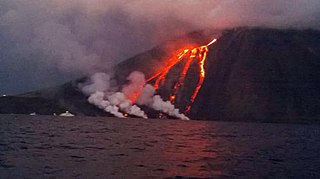
The 2002 Stromboli tsunami was a tsunami caused by a volcanic eruption on the island of Stromboli, in the Aeolian Islands of Sicily, located on the Tyrrhenian Sea. In May 2002, one of the island's two active volcanoes, called Stromboli, entered a new phase of explosive activity that was initially characterized by gas and ash emission from the summit craters. On December 30, 2002, the seismic network recorded two large collapses of a huge portion of the Sciara del Fuoco, which resulted in the tsunamis. The first landslide was around 13:15 and the second one around 13:23 which lasted for 5–7 minutes. The event caused damages on the eastern coast side of Stromboli and Panarea. These tsunamis have been considered the most violent ones that have struck Stromboli in the past 100 years.

Fabrizio Curcio is an Italian government official, who served as Head of the Civil Protection from 3 April 2015 to 8 August 2017 and again since 26 February 2021.